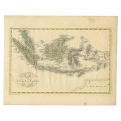
Items Similar to Antique Colourful Map of the Dutch East Indies 'Indonesia', ca.1806


Want more images or videos?
Request additional images or videos from the seller
1 of 5
Antique Colourful Map of the Dutch East Indies 'Indonesia', ca.1806
$671.54
£499.56
€560
CA$919.57
A$1,022.43
CHF 533.86
MX$12,445.52
NOK 6,811.81
SEK 6,382.34
DKK 4,262.97
Shipping
Retrieving quote...The 1stDibs Promise:
Authenticity Guarantee,
Money-Back Guarantee,
24-Hour Cancellation
About the Item
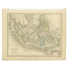
Antique map titled 'Les Isles de la Sonde Moluques Philippines, Carolines et Marianes'. Old map of the East Indies, also showing a part of Australia.
Artists and Engravers: Published by C.F. Delamarche.
Condition: Very good, please study image carefully.
Date: c.1806
Overall size: 47 x 33.5 cm.
Image size: 26 x 24 cm.
We sell original antique maps to collectors, historians, educators and interior decorators all over the world. Our collection includes a wide range of authentic antique maps from the 16th to the 20th centuries. Buying and collecting antique maps is a tradition that goes back hundreds of years. Antique maps have proved a richly rewarding investment over the past decade, thanks to a growing appreciation of their unique historical appeal. Today the decorative qualities of antique maps are widely recognized by interior designers who appreciate their beauty and design flexibility. Depending on the individual map, presentation, and context, a rare or antique map can be modern, traditional, abstract, figurative, serious or whimsical. We offer a wide range of authentic antique maps for any budget.
- Dimensions:Height: 17.33 in (44 cm)Width: 22.45 in (57 cm)Depth: 0 in (0.01 mm)
- Materials and Techniques:
- Period:
- Date of Manufacture:circa 1806
- Condition:Condition: Very good, please study image carefully.
- Seller Location:Langweer, NL
- Reference Number:Seller: BG-117511stDibs: LU3054327793092
About the Seller
5.0
Recognized Seller
These prestigious sellers are industry leaders and represent the highest echelon for item quality and design.
Platinum Seller
Premium sellers with a 4.7+ rating and 24-hour response times
Established in 2009
1stDibs seller since 2017
2,510 sales on 1stDibs
Typical response time: <1 hour
- ShippingRetrieving quote...Shipping from: Langweer, Netherlands
- Return Policy
Authenticity Guarantee
In the unlikely event there’s an issue with an item’s authenticity, contact us within 1 year for a full refund. DetailsMoney-Back Guarantee
If your item is not as described, is damaged in transit, or does not arrive, contact us within 7 days for a full refund. Details24-Hour Cancellation
You have a 24-hour grace period in which to reconsider your purchase, with no questions asked.Vetted Professional Sellers
Our world-class sellers must adhere to strict standards for service and quality, maintaining the integrity of our listings.Price-Match Guarantee
If you find that a seller listed the same item for a lower price elsewhere, we’ll match it.Trusted Global Delivery
Our best-in-class carrier network provides specialized shipping options worldwide, including custom delivery.More From This Seller
View AllAntique Map of the East Indies by Van der Aa '1849'
Located in Langweer, NL
Antique map titled 'Kaart van Nederlands OostIndie door A.J. van der Aa'. Old map of the Dutch East Indies. This map originates from 'Nederlands Oost-Indië, of beschrijving der Neder...
Category
Antique Mid-19th Century Maps
Materials
Paper

$383 Sale Price
20% Off
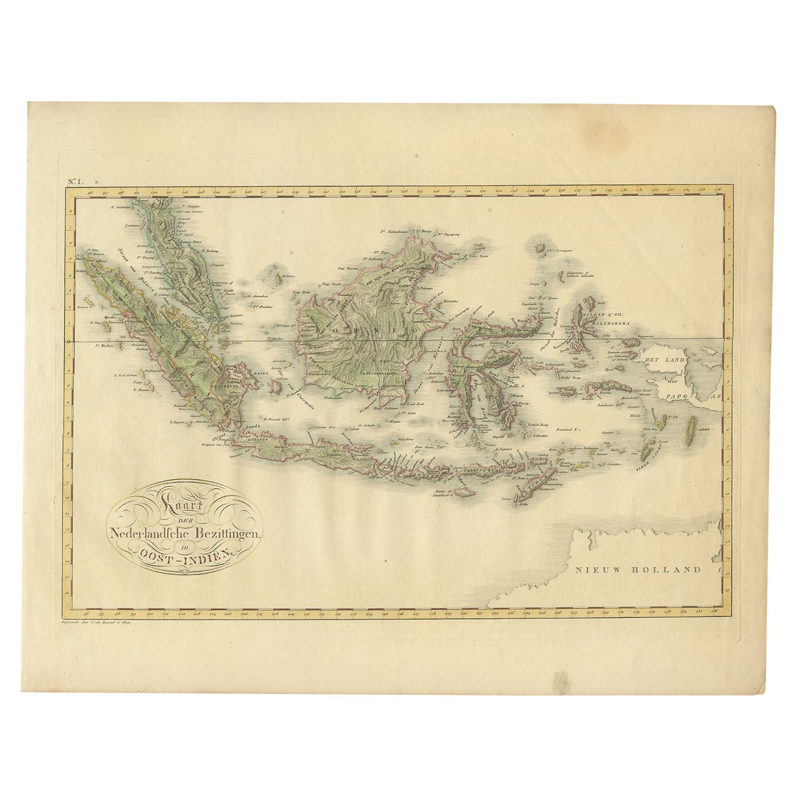
Antique Map of the Dutch East Indies by Van den Bosch '1818'
Located in Langweer, NL
Antique map titled 'Kaart der Nederlandsche Bezittingen in Oost-Indiën'.
Rare and attractive map of the Dutch East Indies, it shows the Dutch possessions in the 19th century. This ...
Category
Antique Early 19th Century Maps
Materials
Paper
$1,343 Sale Price
20% Off
Antique Map of the East Indies by Bonne '1776'
Located in Langweer, NL
Antique map titled 'Indes IVe Feuille'. Very decorative original antique map of the East Indies. Covbers from the Gulf of Siam (Gulf of Thailand) and Malacca (Malaysia) eastward to i...
Category
Antique Late 18th Century Maps
Materials
Paper

$527 Sale Price
20% Off
Antique Map of the East Indies by Wyld '1845'
Located in Langweer, NL
Antique map titled 'Archipelago of the Indian Ocean'. Original antique map of the East Indies. This map originates from 'An Atlas of the World, Comprehending Separate Maps of its Var...
Category
Antique Mid-19th Century Maps
Materials
Paper

$335 Sale Price
20% Off
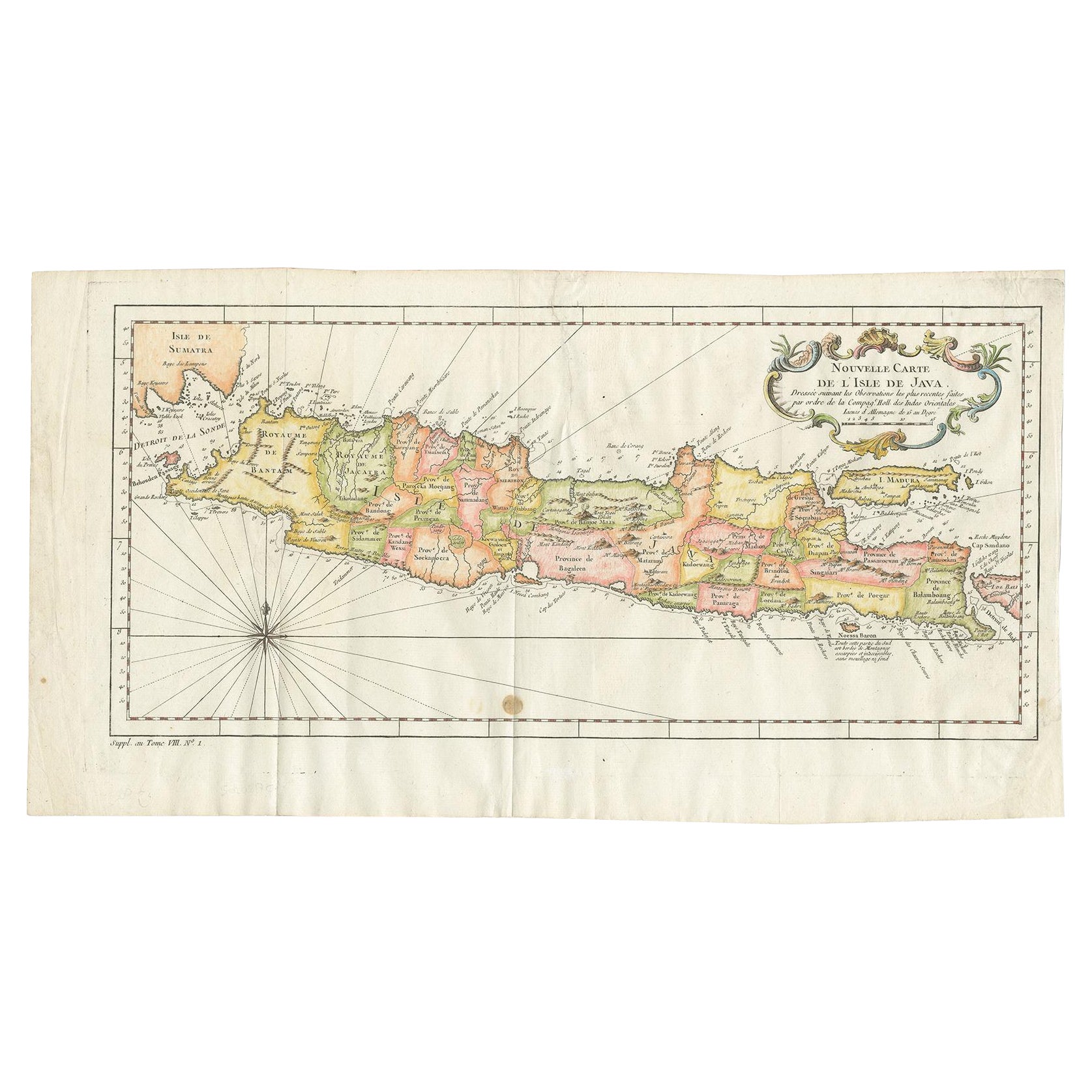
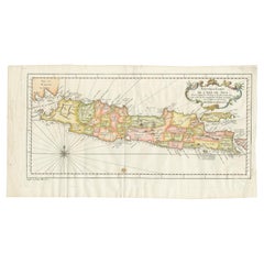
Antique Colourful Map of the Island of Java and Madura, Indonesia, C.1760
Located in Langweer, NL
Antique map titled 'Nouvelle Carte de l'Isle de Java'.
Chart of the island of Java, depicting soundings around the coast, all principal harbors, rivers and elevations, bays and p...
Category
Antique 18th Century Maps
Materials
Paper
$431 Sale Price
20% Off
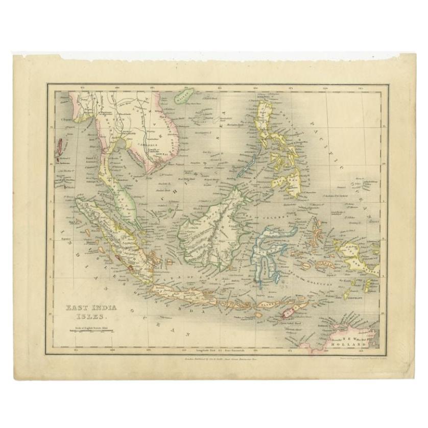
Antique Map of the East Indies by Dower, 1832
Located in Langweer, NL
Antique map titled 'East India Isles'. Old map of the East Indies. This map originates from 'A General Descriptive Atlas Of The Earth (..)' by J. Dower.
Artists and Engravers: Dr...
Category
Antique 19th Century Maps
Materials
Paper
$158 Sale Price
20% Off
You May Also Like
Antique 1803 Italian Map of Asia Including China Indoneseia India
Located in Amsterdam, Noord Holland
Antique 1803 Italian Map of Asia Including China Indoneseia India
Very nice map of Asia. 1803.
Additional information:
Type: Map
Country of Manufacturing: Europe
Period: 19th centu...
Category
Antique 19th Century European Maps
Materials
Paper

$584 Sale Price
20% Off
Map of the East Indies: An Original 18th Century Hand-colored Map by E. Bowen
Located in Alamo, CA
This is an original 18th century hand-colored map entitled "An Accurate Map of the East Indies Exhibiting the Course of the European Trade both on the Continent and Islands" by Emanu...
Category
Mid-18th Century Old Masters Landscape Prints
Materials
Engraving

Antique French Map of Asia Including China Indoneseia India, 1783
Located in Amsterdam, Noord Holland
Very nice map of Asia. 1783 Dedie au Roy.
Additional information:
Country of Manufacturing: Europe
Period: 18th century Qing (1661 - 1912)
Condition: Overall Condition B (Good Used)...
Category
Antique 18th Century European Maps
Materials
Paper

$648 Sale Price
20% Off
Original Antique Map of South East Asia by Thomas Clerk, 1817
Located in St Annes, Lancashire
Great map of South East Asia
Copper-plate engraving
Drawn and engraved by Thomas Clerk, Edinburgh.
Published by Mackenzie And Dent, 1817
Unframed.
Category
Antique 1810s English Maps
Materials
Paper

California, Alaska and Mexico: 18th Century Hand-Colored Map by de Vaugondy
By Didier Robert de Vaugondy
Located in Alamo, CA
This is an 18th century hand-colored map of the western portions of North America entitled "Carte de la Californie et des Pays Nord-Ouest separés de l'Asie par le détroit d'Anian, ex...
Category
Antique 1770s French Maps
Materials
Paper

Hand-Colored 18th Century Homann Map of Denmark and Islands in the Baltic Sea
By Johann Baptist Homann
Located in Alamo, CA
An 18th century copper plate hand-colored map entitled "Insulae Danicae in Mari Balthico Sitae utpote Zeelandia, Fionia, Langelandia, Lalandia, Falstria, Fembria Mona" created by Joh...
Category
Antique Early 18th Century German Maps
Materials
Paper

More Ways To Browse
Dutch East Indies
French School Map
Nova Scotia Antique Furniture
Richard Wentworth
Antique Mace
Map Of Madagascar
Map Of Normandy
Bali Map
Croatia Map
Gibraltar Antique Map
Albania Antique Map
Antique Furniture Kingston
Antique Louisiana Map
Armenia Map
L Tardieu
Chinese Wall Pocket
18th Century Nautical Engraving
Antique Map Burgundy