Items Similar to Antique Decorative Coloured Map Egypt, Nubia, Abyssinia and more, 1882


Want more images or videos?
Request additional images or videos from the seller
1 of 7
Antique Decorative Coloured Map Egypt, Nubia, Abyssinia and more, 1882
$299.54
£222.94
€250
CA$410.29
A$456.33
CHF 238.28
MX$5,553.07
NOK 3,043.22
SEK 2,854.01
DKK 1,903.16
Shipping
Retrieving quote...The 1stDibs Promise:
Authenticity Guarantee,
Money-Back Guarantee,
24-Hour Cancellation
About the Item
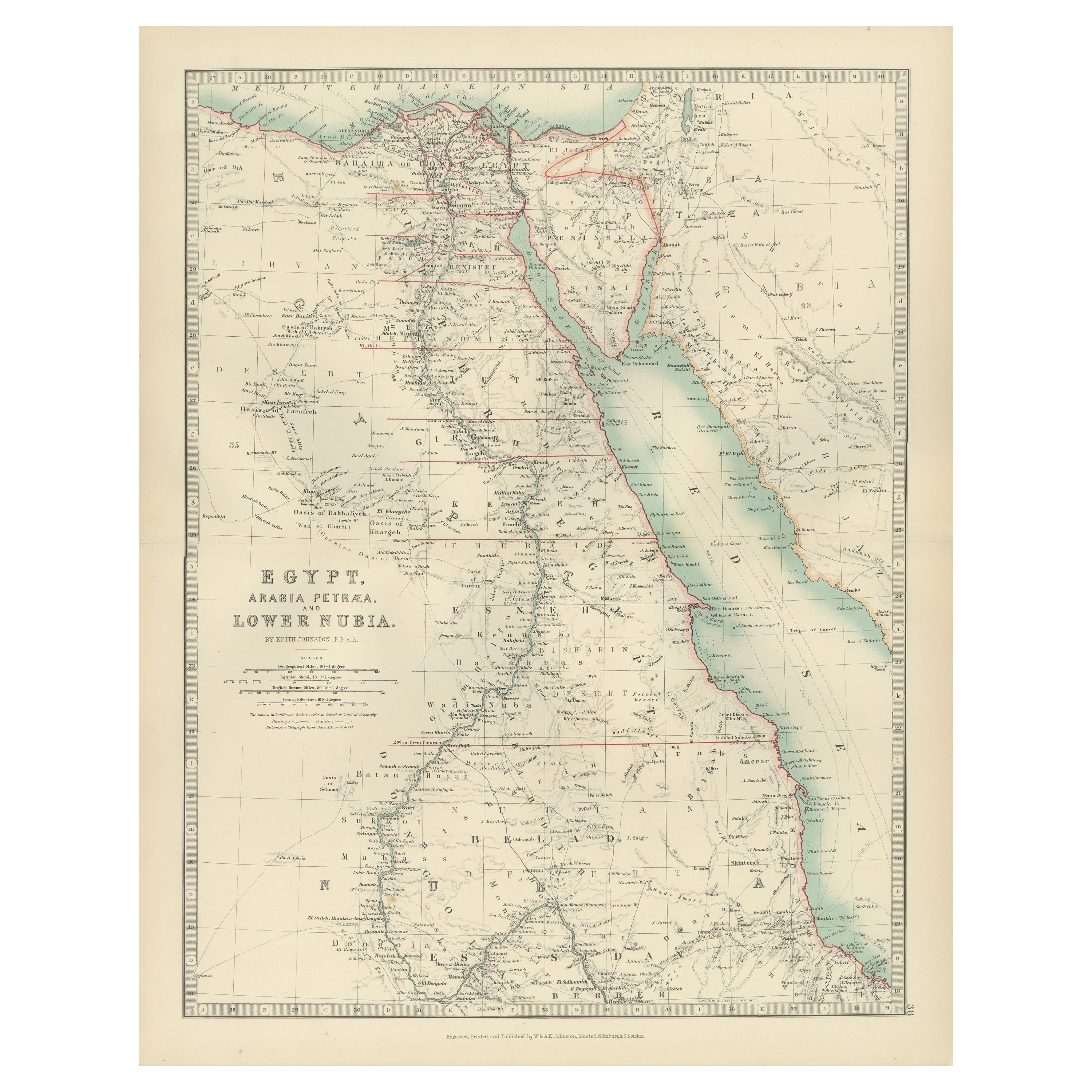
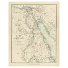
This image contains two maps, with the left one being labeled "Egypt" and the right one "Nubia, Abyssinia and the Adjacent Lands." These maps highlight the Nile Valley and surrounding regions.
The maps from the Blackie & Son atlas published in 1882 are interesting for several reasons:
1. **Historical Context**: The year 1882 is significant because it falls within the period of European imperial expansion in Africa. It was also just before the British occupation of Egypt, which began that year. Therefore, the maps serve as historical documents showing the geopolitical state of the region just before a major shift in its colonial status.
2. **Cartographic Style**: The maps reflect the cartographic style of the late 19th century, which often featured detailed engravings and fine detail. They provide a snapshot of the cartographic knowledge and aesthetic of the time.
3. **Geographical Knowledge**: These maps were created during a time when much of Africa's interior was still being explored by Europeans. The representation of features like rivers, mountains, and settlements can tell us about the extent of geographical knowledge at the time.
4. **Cultural Representation**: The way the map represents different regions, peoples, and geographical features can give insights into the cultural and political views of the era. It may reflect the European understanding and biases towards these regions.
5. **Educational Purpose**: Blackie & Son were known for their educational materials. This atlas was likely used in schools and libraries, making it an instrument of learning for many individuals. How the atlas was intended to educate its British audience about the world beyond their borders is of historical interest.
6. **Colonial Borders**: The atlas predates the 1884 Berlin Conference where European powers divided Africa into spheres of influence, leading to the drawing of new borders. This map may not show those later colonial borders, offering insight into pre-colonial boundaries.
7. **Technical Skill**: The precision and artistry involved in creating such detailed maps without the aid of modern technology is a testament to the skill of the cartographers of the time.
8. **Condition and Preservation**: Considering the map's age, its condition can also be a point of interest. How well it has been preserved can tell us about the quality of the materials used and the care taken to maintain it over the years.
Examining the map might reveal other unique or historically significant features, such as trade routes, historical notes, or even indications of the prevailing theories about the source of the Nile, which was a major geographical mystery at the time.
- Dimensions:Height: 14.97 in (38 cm)Width: 22.45 in (57 cm)Depth: 0 in (0.02 mm)
- Materials and Techniques:
- Period:
- Date of Manufacture:1882
- Condition:Good condition, folding line in the middle. The outer borders are slightly discolored due to age, but not the image. This map is ideal for framing. Study the image carefully.
- Seller Location:Langweer, NL
- Reference Number:Seller: BG-13601-2-541stDibs: LU3054338775652
About the Seller
5.0
Recognized Seller
These prestigious sellers are industry leaders and represent the highest echelon for item quality and design.
Platinum Seller
Premium sellers with a 4.7+ rating and 24-hour response times
Established in 2009
1stDibs seller since 2017
2,508 sales on 1stDibs
Typical response time: <1 hour
- ShippingRetrieving quote...Shipping from: Langweer, Netherlands
- Return Policy
Authenticity Guarantee
In the unlikely event there’s an issue with an item’s authenticity, contact us within 1 year for a full refund. DetailsMoney-Back Guarantee
If your item is not as described, is damaged in transit, or does not arrive, contact us within 7 days for a full refund. Details24-Hour Cancellation
You have a 24-hour grace period in which to reconsider your purchase, with no questions asked.Vetted Professional Sellers
Our world-class sellers must adhere to strict standards for service and quality, maintaining the integrity of our listings.Price-Match Guarantee
If you find that a seller listed the same item for a lower price elsewhere, we’ll match it.Trusted Global Delivery
Our best-in-class carrier network provides specialized shipping options worldwide, including custom delivery.More From This Seller
View AllAntique Map of Egypt and Arabia Petraea by A & C. Black, 1870
Located in Langweer, NL
Antique map titled 'Egypt and Arabia Petraea'. Original antique map of Egypt and Arabia Petraea. This map originates from ‘Black's General Atlas of The World’. Published by A & C. Bl...
Category
Antique Late 19th Century Maps
Materials
Paper

$146 Sale Price
30% Off
Antique Map of Egypt, Arabia Petraea and Lower Nubia by Johnston '1909'
Located in Langweer, NL
Antique map titled 'Egypt, Arabia Petraea and Lower Nubia'. Original antique map of Egypt, Arabia Petraea and Lower Nubia. With inset maps of Alexandriam Cairo and the Suez Canal...
Category
Early 20th Century Maps
Materials
Paper

$225 Sale Price
24% Off
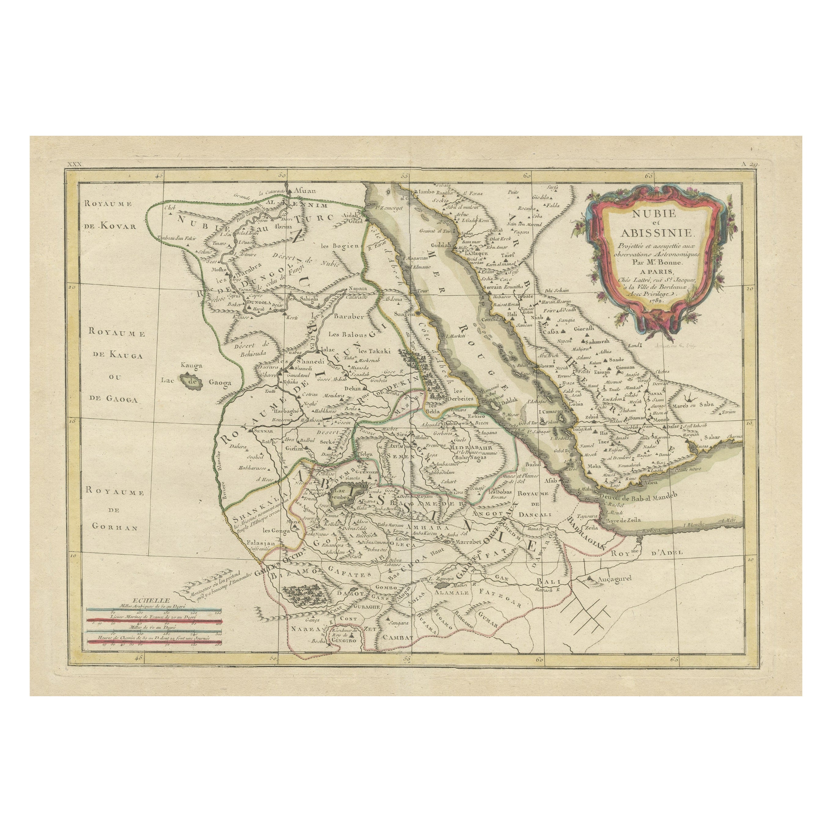
Antique Map of Arabia including Nubia and Abyssinia, also shows the Red Sea
Located in Langweer, NL
Antique map titled 'Nubie et Abissinie'. Original antique map of Nubia, a region along the Nile river, and Abyssinia or the Ethiopian Empire. This map o...
Category
Antique Late 18th Century Maps
Materials
Paper

$824 Sale Price
20% Off
Antique Map of Egypt, '1875'
Located in Langweer, NL
Antique map titled 'Carte des l'Égypte'. Large map of Egypt. This map originates from 'Atlas de Géographie Moderne Physique et Politique' by A. Levasseur....
Category
Antique Late 19th Century Maps
Materials
Paper

$335 Sale Price
30% Off
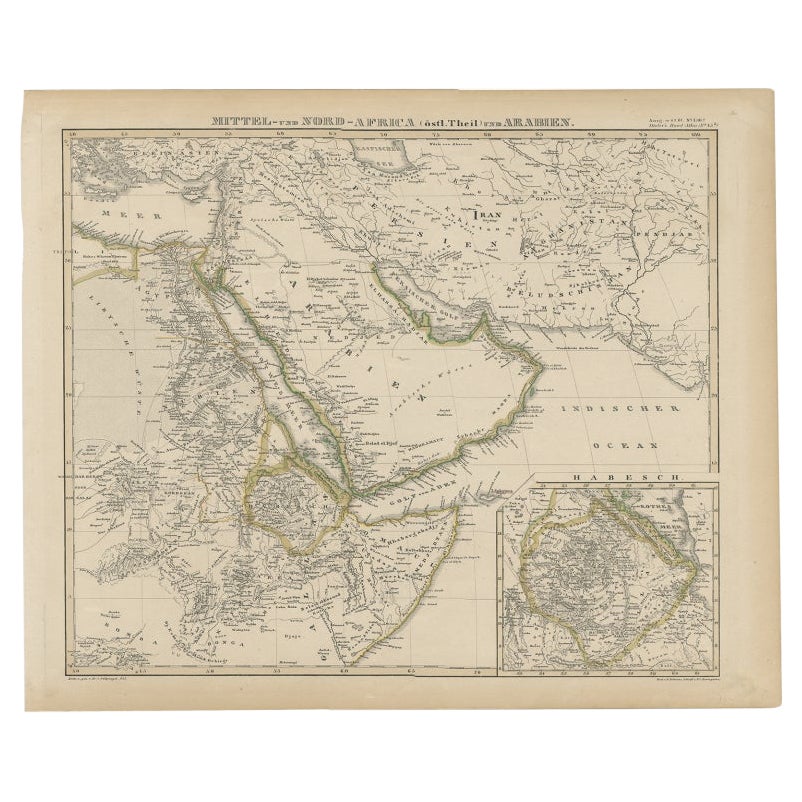
Antique Map of Africa and Arabia with Inset Map of Ethiopia and Eritrea, 1845
Located in Langweer, NL
Antique map titled 'Mittel- und Nord-Africa (östl. Theil) und Arabien'. This map depicts North and Central Africa and Arabia with an inset map of Habesch (Ethiopia and Eritrea).
Ar...
Category
Antique 19th Century Maps
Materials
Paper
$210 Sale Price
20% Off
Egypt and Lower Nubia, 1903 - Historical Map Highlighting Nile and Red Sea
Located in Langweer, NL
Egypt and Lower Nubia, 1903 - Historical Map Highlighting Nile and Red Sea
This beautifully detailed map titled "Egypt, Arabia Petraea, and Lower Nubia" was engraved, printed, and p...
Category
Early 20th Century Maps
Materials
Paper
You May Also Like
Large Original Vintage Map of Egypt, circa 1920
Located in St Annes, Lancashire
Great map of Egypt
Unframed
Original color
By John Bartholomew and Co. Edinburgh Geographical Institute
Published, circa 1920
Free shipping.
Category
Vintage 1920s British Maps
Materials
Paper

Africa. North-East Part. Century Atlas antique vintage map
Located in Melbourne, Victoria
'The Century Atlas. Africa. North-East Part'
Original antique map, 1903.
Inset map of 'Nile Delta and Suez Canal'.
Central fold as issued. Map name and nu...
Category
Early 20th Century Victorian More Prints
Materials
Lithograph

Map of the Holy Land "Carte de la Syrie et de l'Egypte" by Pierre M. Lapie
By Pierre M. Lapie
Located in Alamo, CA
An early 19th century map of ancient Syria and Egypt entitled "Carte de la Syrie et de l'Egypte anciennes/dressée par M. Lapie, Colonel d'Etat Major, et...
Category
Antique Early 19th Century French Maps
Materials
Paper

Large Original Antique Map of Morocco. Edward Weller, 1861
Located in St Annes, Lancashire
Great map of Morocco
Lithograph engraving by Edward Weller
Original colour
Published, 1861
Unframed
Good condition.
Category
Antique 1860s English Victorian Maps
Materials
Paper

Africa. North-West Part. Century Atlas antique vintage map
Located in Melbourne, Victoria
'The Century Atlas. Africa. Southern Part'
Original antique map, 1903.
Central fold as issued. Map name and number printed on the reverse corners.
Sheet 40cm by 29.5cm.
Category
Early 20th Century Victorian More Prints
Materials
Lithograph

Large Original Antique Map of Afghanistan. Edward Weller, 1861
Located in St Annes, Lancashire
Great map of Afghanistan
Lithograph engraving by Edward Weller
Original colour
Published, 1861
Unframed
Good condition
Category
Antique 1860s English Victorian Maps
Materials
Paper

More Ways To Browse
Antique Drawing Instruments
20th Century Spanish Table
Antonio Bellini
Antique Oushak Carpets
Blue Coffee Tables
German Bauhaus Posters
1945 Chair Juhl
Antique Three Leg Table
Folke Arstrom
Silver Over Copper
Vintage Barware Glasses
Antique Etched Glass
Antique French Shell
Coffee Table Black Italian Modern
Christofle America
Iranian Silk Rug Carpet
Poul Moller
Tables With Inlaid Wood