Items Similar to Antique Decorative Coloured Map Marocco, Algeria and Tunis, 1882


Want more images or videos?
Request additional images or videos from the seller
1 of 6
Antique Decorative Coloured Map Marocco, Algeria and Tunis, 1882
$239.84
$299.7920% Off
£178.41
£223.0220% Off
€200
€25020% Off
CA$328.42
CA$410.5220% Off
A$365.16
A$456.4420% Off
CHF 190.66
CHF 238.3320% Off
MX$4,444.83
MX$5,556.0420% Off
NOK 2,432.79
NOK 3,040.9920% Off
SEK 2,279.41
SEK 2,849.2620% Off
DKK 1,522.49
DKK 1,903.1120% Off
Shipping
Retrieving quote...The 1stDibs Promise:
Authenticity Guarantee,
Money-Back Guarantee,
24-Hour Cancellation
About the Item
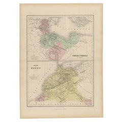
The maps is from the 1882 atlas by Blackie & Son and offers a detailed view of the North African regions as understood in the late 19th century.
**Map of Morocco, Algeria, and Tunis:**
This map details the North African coast from Morocco to Tunisia, showing major cities, towns, and geographical features such as the Sahara Desert, the Atlas Mountains, and the Mediterranean coast. The map is colored to distinguish between the three regions, which were of strategic interest to colonial powers.
The maps would have been used for educational purposes, as well as by explorers, merchants, and colonial administrators of the era. They reflect the Victorian era's cartographic capabilities, as well as the geopolitical interests of the time. The maps are a fascinating historical record, showing how these regions were perceived and understood by Western cartographers in the 19th century.
The map of Morocco, Algeria, and Tunis from the 1882 atlas by Blackie & Son is interesting for several reasons:
1. **Historical Context**: During the 1880s, European powers were heavily involved in the colonization of Africa. This map offers a snapshot of the geopolitical landscape of the time, just before the 'Scramble for Africa' intensified. The region it covers was of significant interest to colonial powers, particularly France, which had a strong presence in Algeria and would soon establish protectorates in Tunisia and Morocco.
2. **Cartographic Detail**: The map provides detailed geographic information of the region. It features the intricate details of the coastal lines, the rugged terrain of the Atlas Mountains, and the vast expanse of the Sahara Desert. Such detail would have been critical for navigation, trade, and military expeditions.
3. **Cultural Significance**: Maps like this one represent the knowledge and perspective of the European cartographers who created them. Place names are often anglicized or written in French, reflecting the influence of European languages and cultures in the region.
4. **Artistic Representation**: The use of color, shading, and detailed geographic representations are not just practical but also artistic. The aesthetic quality of such maps makes them valuable for historical and visual studies.
5. **Navigational Aid**: For ships navigating the Mediterranean Sea, the map would have been an essential tool. It shows important ports and cities along the coast, which would have been stops for trade and refueling.
6. **Comparative Analysis**: When viewed alongside modern maps, it allows us to see how borders, place names, and political realities have changed over time, providing a comparative historical perspective.
In summary, the map of Morocco, Algeria, and Tunis is a rich historical document, offering insights into the colonial mindset, the state of geographical knowledge at the time, and the natural and political landscape of North Africa as it stood in the late 19th century.
- Dimensions:Height: 14.97 in (38 cm)Width: 22.45 in (57 cm)Depth: 0 in (0.02 mm)
- Materials and Techniques:
- Period:
- Date of Manufacture:1882
- Condition:Good condition, folding line in the middle. The outer borders are slightly discolored due to age, but not the image. This map is ideal for framing. Study the image carefully.
- Seller Location:Langweer, NL
- Reference Number:Seller: BG-13601-2-531stDibs: LU3054338775622
About the Seller
5.0
Recognized Seller
These prestigious sellers are industry leaders and represent the highest echelon for item quality and design.
Platinum Seller
Premium sellers with a 4.7+ rating and 24-hour response times
Established in 2009
1stDibs seller since 2017
2,511 sales on 1stDibs
Typical response time: <1 hour
- ShippingRetrieving quote...Shipping from: Langweer, Netherlands
- Return Policy
Authenticity Guarantee
In the unlikely event there’s an issue with an item’s authenticity, contact us within 1 year for a full refund. DetailsMoney-Back Guarantee
If your item is not as described, is damaged in transit, or does not arrive, contact us within 7 days for a full refund. Details24-Hour Cancellation
You have a 24-hour grace period in which to reconsider your purchase, with no questions asked.Vetted Professional Sellers
Our world-class sellers must adhere to strict standards for service and quality, maintaining the integrity of our listings.Price-Match Guarantee
If you find that a seller listed the same item for a lower price elsewhere, we’ll match it.Trusted Global Delivery
Our best-in-class carrier network provides specialized shipping options worldwide, including custom delivery.More From This Seller
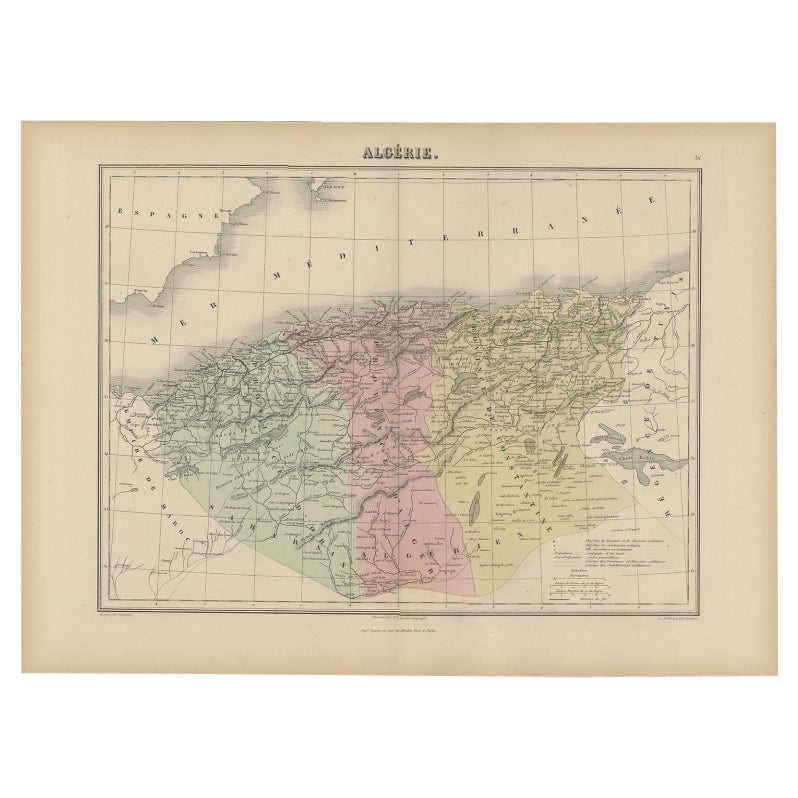
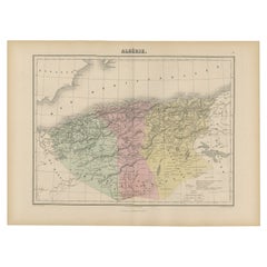
View AllAntique Map of Algeria, 1880
Located in Langweer, NL
Antique map titled 'Algérie. Old map of Algeria. This map originates from 'Géographie Universelle Atlas-Migeon' by J. Migeon.
Artists and Engravers: Published by J. Migeon. Review...
Category
Antique 19th Century Maps
Materials
Paper
$211 Sale Price
20% Off
Antique Map of Algeria and the French Colonies, 1875
Located in Langweer, NL
Antique map titled 'Algérie et Colonies Francaises'. Large map of Algeria and the French Colonies. This map originates from 'Atlas de Géographie Moderne Physique et Politique' by A. ...
Category
Antique Late 19th Century French Maps
Materials
Paper

$311 Sale Price
35% Off
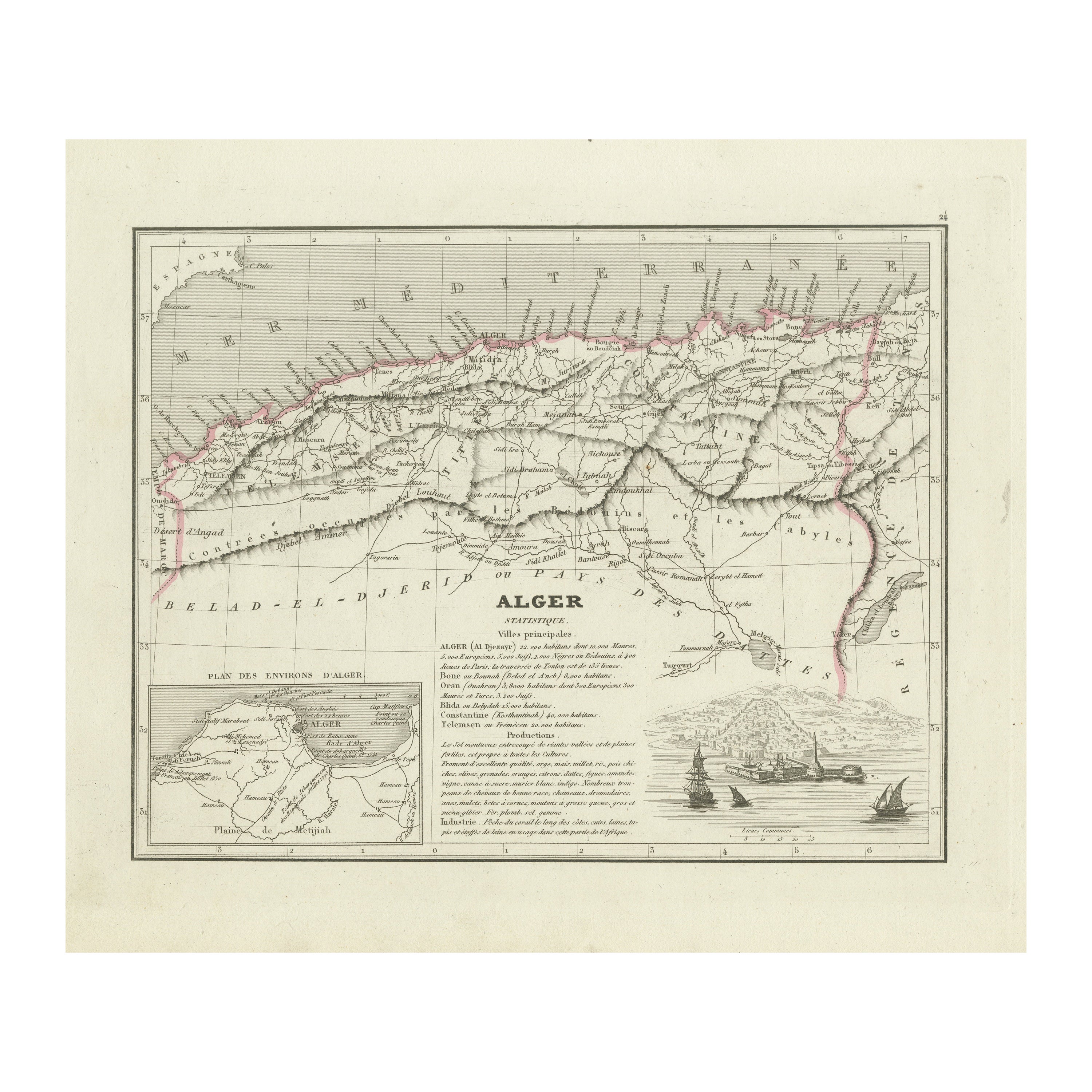
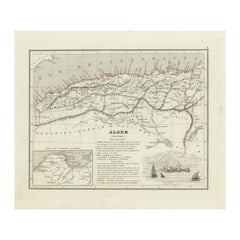
Antique Map of the Region of Algiers, Algeria
Located in Langweer, NL
Antique map titled 'Alger'. This map shows the region of Algiers, Algeria. With a small inset map of the region of Algiers and a decorative vignette with a harbor view. Originates fr...
Category
Antique Mid-19th Century Maps
Materials
Paper
$163 Sale Price
20% Off
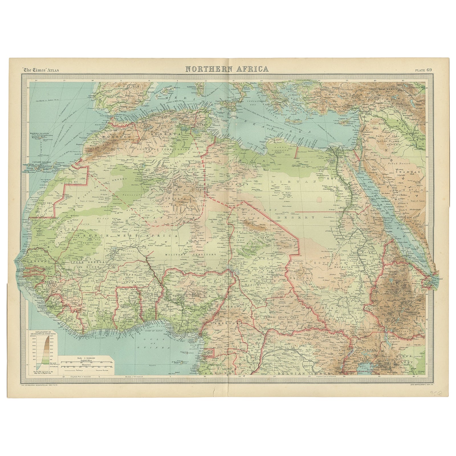
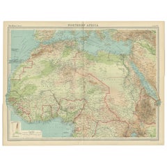
Old Map of North Africa Depicting Libya, Morocco, Algeria, Tunis Etc, 1922
Located in Langweer, NL
Antique map of Africa titled 'Northern Africa'.
Old map of North Africa depicting Libya, Morocco, Algeria, Tunis and surroundings. This map originates from 'The Times' atlas.
...
Category
Vintage 1920s Maps
Materials
Paper
$115 Sale Price
20% Off
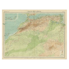
Antique Map of Northwest Africa by Bartholomew, 1922
Located in Langweer, NL
Antique map of Africa titled 'North-West Africa'. Old map of north-west Africa depicting Morocco, Algeria, Tunis and surroundings. This map originates from 'The Times' atlas. Artists...
Category
20th Century Maps
Materials
Paper
$91 Sale Price
20% Off
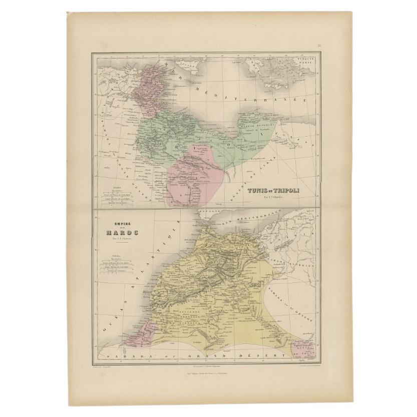
Antique Map of Tunis and Tripoli in Northern Africa, circa 1880
By J. Migeon
Located in Langweer, NL
Antique map titled 'Tunis et Tripoli & Empire de Maroc'. Old map of Tunis and Tripoli and the Empire of Morocco. This map originates from 'Géographie Universelle Atlas-Migeon' by J. ...
Category
Antique 19th Century Maps
Materials
Paper
$153 Sale Price
20% Off
You May Also Like
Large Original Antique Map of Morocco. Edward Weller, 1861
Located in St Annes, Lancashire
Great map of Morocco
Lithograph engraving by Edward Weller
Original colour
Published, 1861
Unframed
Good condition.
Category
Antique 1860s English Victorian Maps
Materials
Paper

Large Original Antique Map of Afghanistan. Edward Weller, 1861
Located in St Annes, Lancashire
Great map of Afghanistan
Lithograph engraving by Edward Weller
Original colour
Published, 1861
Unframed
Good condition
Category
Antique 1860s English Victorian Maps
Materials
Paper

Africa. North-West Part. Century Atlas antique vintage map
Located in Melbourne, Victoria
'The Century Atlas. Africa. Southern Part'
Original antique map, 1903.
Central fold as issued. Map name and number printed on the reverse corners.
Sheet 40cm by 29.5cm.
Category
Early 20th Century Victorian More Prints
Materials
Lithograph

Large Original Antique Map of Cyprus. 1894
Located in St Annes, Lancashire
Superb Antique map of Cyprus
Published Edward Stanford, Charing Cross, London 1894
Original colour
Good condition
Unframed.
Free shipping
Category
Antique 1890s English Maps
Materials
Paper

Map of the Holy Land "Carte de la Syrie et de l'Egypte" by Pierre M. Lapie
By Pierre M. Lapie
Located in Alamo, CA
An early 19th century map of ancient Syria and Egypt entitled "Carte de la Syrie et de l'Egypte anciennes/dressée par M. Lapie, Colonel d'Etat Major, et...
Category
Antique Early 19th Century French Maps
Materials
Paper

Ancient National Atlas of France with Marengo
Located in Alessandria, Piemonte
Ancient National Atlas of France with the department of Marengo: a rare French etching dated 1806.
ST/178.
Category
Antique Early 19th Century French Other Prints
Materials
Paper

More Ways To Browse
Sahara Desert
Antique African Tools
20th Century Spanish Table
Antonio Bellini
Antique Oushak Carpets
Blue Coffee Tables
German Bauhaus Posters
1945 Chair Juhl
Antique Three Leg Table
Folke Arstrom
Silver Over Copper
Vintage Barware Glasses
Antique Etched Glass
Antique French Shell
Coffee Table Black Italian Modern
Christofle America
Iranian Silk Rug Carpet
Poul Moller