Items Similar to Antique Decorative Coloured Map of South Africa and Madagascar, 1882


Want more images or videos?
Request additional images or videos from the seller
1 of 7
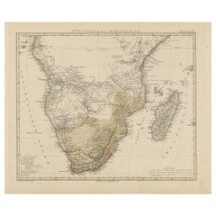
Antique Decorative Coloured Map of South Africa and Madagascar, 1882
$299.79
£223.02
€250
CA$410.52
A$456.44
CHF 238.33
MX$5,556.04
NOK 3,040.99
SEK 2,849.26
DKK 1,903.11
Shipping
Retrieving quote...The 1stDibs Promise:
Authenticity Guarantee,
Money-Back Guarantee,
24-Hour Cancellation
About the Item
The map of South Africa is from the Blackie & Son Atlas, published in 1882. This historical map is quite interesting for several reasons:
1. **Historical Period**: This map was created during a significant period in South African history, just before the discovery of gold and diamonds led to the rapid economic development of the region and, subsequently, to the conflicts of the Anglo-Boer Wars at the end of the 19th century.
2. **Geographical Detail**: It displays the topographical features of South Africa, including mountain ranges such as the Drakensberg, and major rivers. It would also possibly show the distribution of the colonial possessions and the independent African states at the time, like the Zulu Kingdom, which had significant historical implications.
3. **Colonial Impact**: The map reflects the territorial knowledge and the extent of colonial impact before the major changes that would come with the mineral revolution and the subsequent scramble for Africa.
4. **Portrayal of the Terrain**: South Africa’s diverse terrain, from the coastal regions to the interior highveld and the arid regions of the northwest, would be depicted, offering insight into the challenges of settlement and development in the region.
5. **Transportation**: Any rail lines, roads, ports, and other infrastructure depicted on the map would show the development of transportation networks critical for colonial expansion and exploitation of natural resources.
6. **Cultural and Political Boundaries**: The map may show the boundaries of different cultural and political entities as they were understood by Europeans at the time, which could differ significantly from today's boundaries.
7. **Cartographic Techniques**: The map showcases the cartographic techniques and styles of the era, including the use of color, shading, and symbols to represent geographical features and political boundaries.
8. **Maritime Details**: Given South Africa’s position on the trade route to Asia, maritime details such as currents and harbors along the coastline would be important for navigation and trade.
Maps from this era are valuable for the historical insights they provide and for understanding the world view and knowledge at the time of their creation.
- Dimensions:Height: 14.97 in (38 cm)Width: 22.45 in (57 cm)Depth: 0 in (0.02 mm)
- Materials and Techniques:
- Period:
- Date of Manufacture:1882
- Condition:Good condition, folding line in the middle. The outer borders are slightly discolored due to age, but not the image. One small tear in the lower margin, not affecting the image. Study the image carefully.
- Seller Location:Langweer, NL
- Reference Number:Seller: BG-13601-2-561stDibs: LU3054338775692
About the Seller
5.0
Recognized Seller
These prestigious sellers are industry leaders and represent the highest echelon for item quality and design.
Platinum Seller
Premium sellers with a 4.7+ rating and 24-hour response times
Established in 2009
1stDibs seller since 2017
2,511 sales on 1stDibs
Typical response time: <1 hour
- ShippingRetrieving quote...Shipping from: Langweer, Netherlands
- Return Policy
Authenticity Guarantee
In the unlikely event there’s an issue with an item’s authenticity, contact us within 1 year for a full refund. DetailsMoney-Back Guarantee
If your item is not as described, is damaged in transit, or does not arrive, contact us within 7 days for a full refund. Details24-Hour Cancellation
You have a 24-hour grace period in which to reconsider your purchase, with no questions asked.Vetted Professional Sellers
Our world-class sellers must adhere to strict standards for service and quality, maintaining the integrity of our listings.Price-Match Guarantee
If you find that a seller listed the same item for a lower price elsewhere, we’ll match it.Trusted Global Delivery
Our best-in-class carrier network provides specialized shipping options worldwide, including custom delivery.More From This Seller
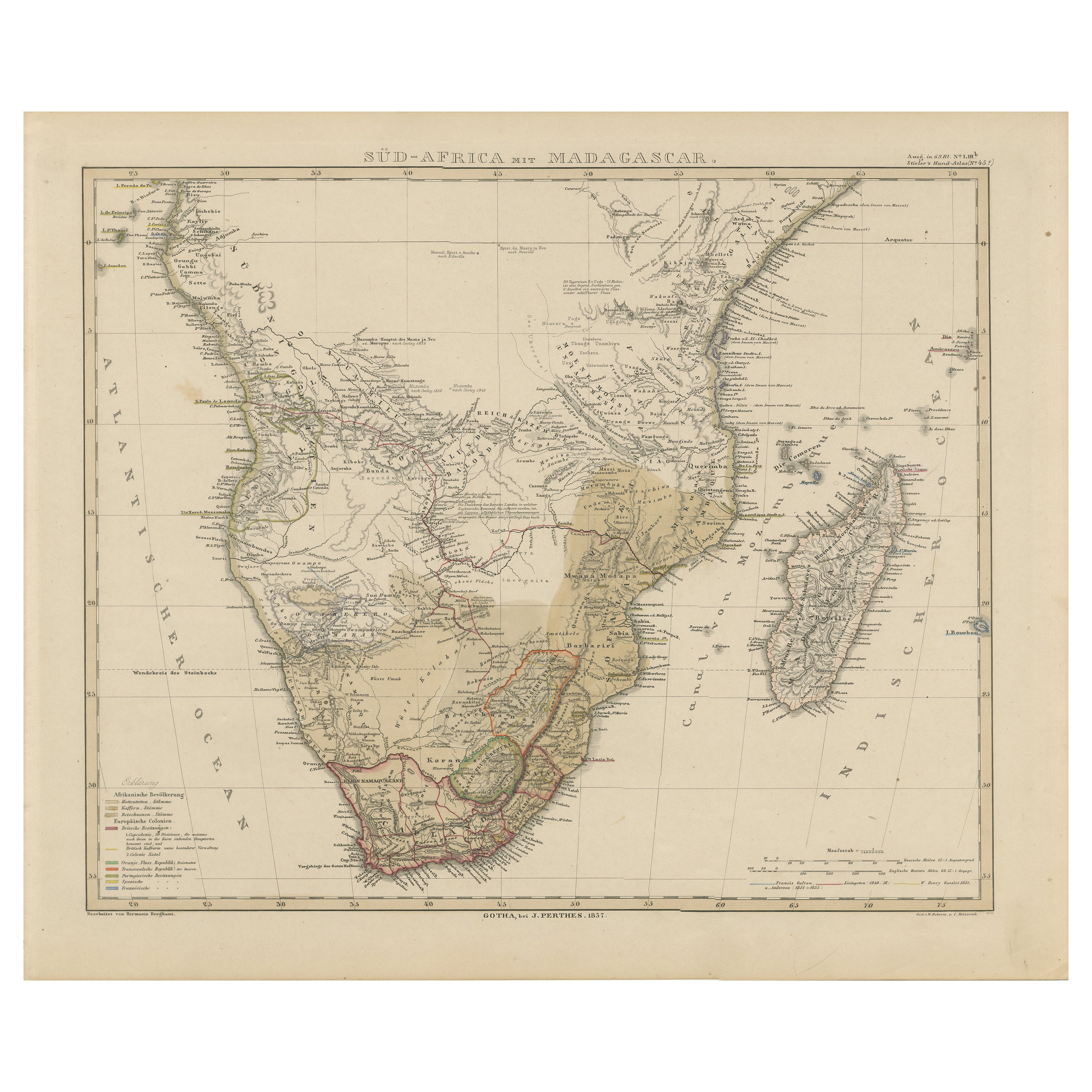
View AllSouthern Africa & Madagascar Antique Map – Beautiful 1857 Edition
Located in Langweer, NL
Southern Africa and Madagascar Map 1857
This detailed antique print shows “Süd-Africa mit Madagascar” meaning “Southern Africa with Madagascar,” published in 1857 by Justus Perthes ...
Category
Antique Mid-19th Century German Maps
Materials
Paper
Antique Map of Southern Africa by Levasseur, 1875
Located in Langweer, NL
Antique map titled 'Afrique Méridionale'. Large map of Southern Africa. This map originates from 'Atlas de Géographie Moderne Physique et Politique' b...
Category
Antique Late 19th Century Maps
Materials
Paper

$383 Sale Price
20% Off
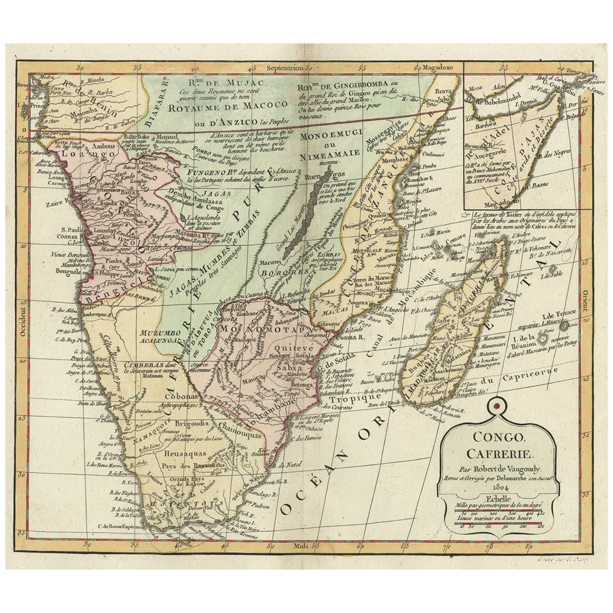
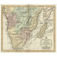
Decorative Antique Map of the Southern Part of Africa, 1806
Located in Langweer, NL
Antique map titled 'Congo, Cafrerie.'
Decorative map of the southern part of Africa by Robert de Vaugondy, revised and published by Delamarche. Source unknown, to be determined.
Artists and Engravers: Charles Francois Delamarche (1740-1817) founded the important and prolific Paris based Maison Delamarche map publishing firm in the late 18th century. A lawyer by trade Delamarche entered the map business with the acquisition from Jean-Baptiste Fortin of Robert de Vaugondy's map plates...
Category
Antique Early 1800s Maps
Materials
Paper
$537 Sale Price
20% Off
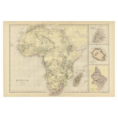
Antique Old Map of Africa with Insets of Mauritius, Reunion and Natal, 1882
Located in Langweer, NL
The uploaded image is a historical map of Africa from the 1882 atlas by Blackie & Son. The map includes the entire African continent, with various countries, regions, and topographic...
Category
Antique 1880s Maps
Materials
Paper
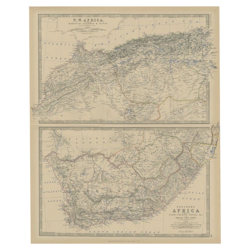
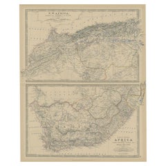
Antique Map of North and South Africa by Johnston, 1882
Located in Langweer, NL
Two antique maps on one sheet titled 'N.W. Africa, Marocco, Algeria & Tunis' and 'Southern Africa, comprising Cape Colony, Natal & c'.
This map originates from 'The Royal Atlas of ...
Category
Antique 19th Century Maps
Materials
Paper
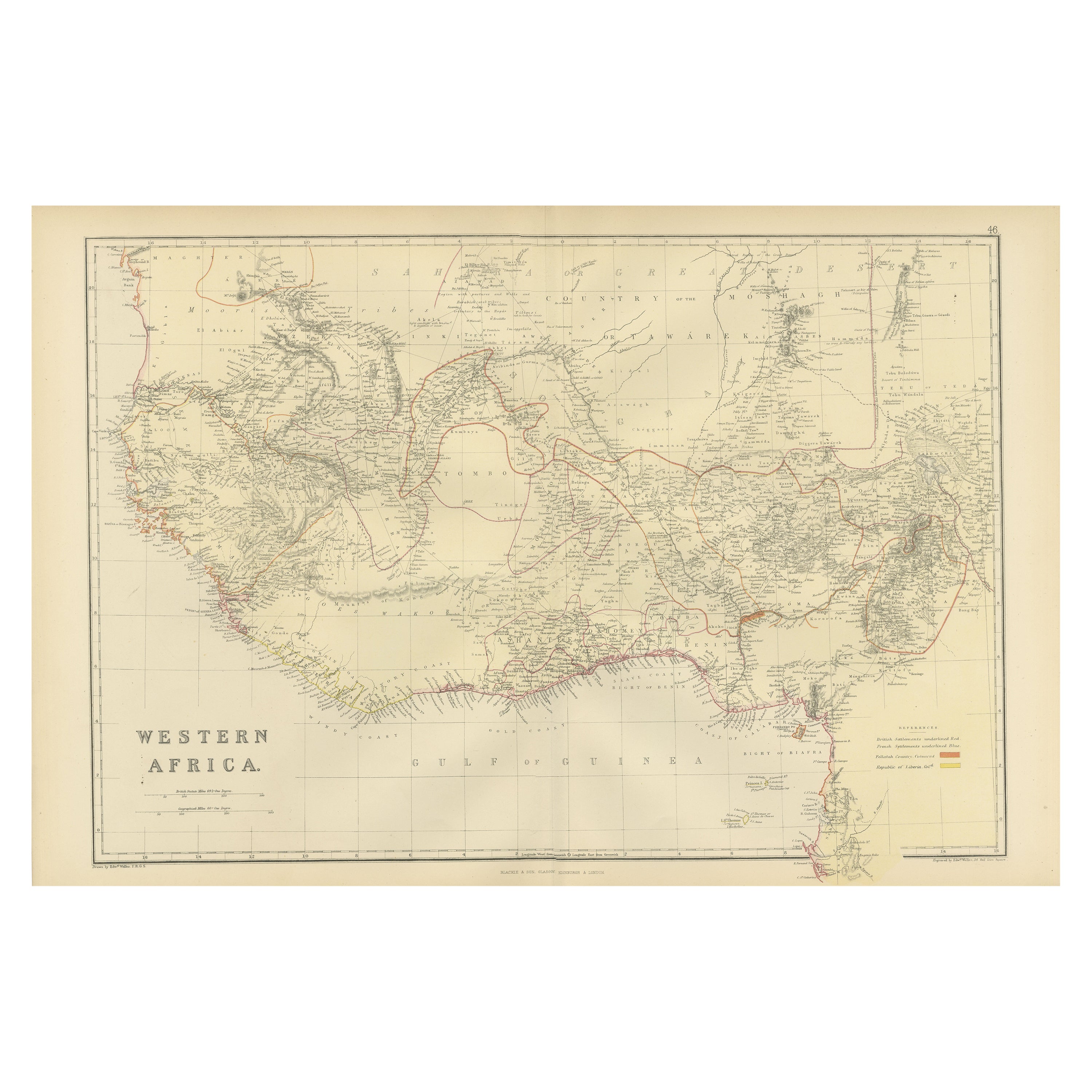
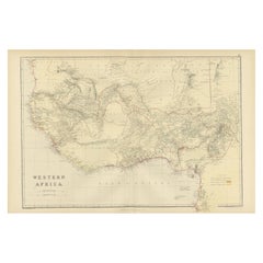
Original Antique Coloured Map of Western Africa, Published in 1882
Located in Langweer, NL
This is a map of Western Africa from the 1882 Blackie & Son atlas. The map details the West African coast from the Sahara Desert in the north down to the Gulf of Guinea, including a ...
Category
Antique 1880s Maps
Materials
Paper
$239 Sale Price
20% Off
Free Shipping
You May Also Like
Large Original Vintage Map of South Africa, circa 1920
Located in St Annes, Lancashire
Great map of South Africa
Original color.
Good condition / repair to a minor edge tear middle bottom
Published by Alexander Gross
Unframed.
...
Category
Vintage 1920s English Edwardian Maps
Materials
Paper

Africa. Southern Part. Century Atlas antique vintage map
Located in Melbourne, Victoria
'The Century Atlas. Africa. Southern Part'
Original antique map, 1903.
Inset maps of 'Cape Town', 'Johannesburg' and 'Ladysmith'.
Central fold as issued. Map name and number printe...
Category
Early 20th Century Victorian More Prints
Materials
Lithograph

Large Original Antique Map of Madagascar. 1894
Located in St Annes, Lancashire
Superb Antique map of Madagascar
Published Edward Stanford, Charing Cross, London 1894
Original colour
Good condition
Unframed.
Free shipping
Category
Antique 1890s English Maps
Materials
Paper

Large Original Antique Map of Africa. C.1900
Located in St Annes, Lancashire
Fabulous map of Africa
Original color.
Engraved and printed by the George F. Cram Company, Indianapolis.
Published, C.1900.
Unframed.
Free shipping.
Category
Antique 1890s American Maps
Materials
Paper

Original Antique Map of Africa by Dower, circa 1835
Located in St Annes, Lancashire
Nice map of Africa
Drawn and engraved by J.Dower
Published by Orr & Smith. C.1835
Unframed.
Free shipping
Category
Antique 1830s English Maps
Materials
Paper

"Africa Vetus": a 17th Century Hand-Colored Map by Sanson
By Nicolas Sanson
Located in Alamo, CA
This original hand-colored copperplate engraved map of Africa entitled "Africa Vetus, Nicolai Sanson Christianiss Galliar Regis Geographi" was originally created by Nicholas Sanson d...
Category
Antique Late 17th Century French Maps
Materials
Paper

More Ways To Browse
South African Gold
Antique South Africa
South African Antique
Antique Furniture South Africa
Africa Colonial
South African Diamonds
Zulu War
20th Century Spanish Table
Antonio Bellini
Antique Oushak Carpets
Blue Coffee Tables
German Bauhaus Posters
1945 Chair Juhl
Antique Three Leg Table
Folke Arstrom
Silver Over Copper
Vintage Barware Glasses
Antique Etched Glass