Items Similar to Original Antique Coloured Map of Western Africa, Published in 1882


Want more images or videos?
Request additional images or videos from the seller
1 of 6
Original Antique Coloured Map of Western Africa, Published in 1882
About the Item
This is a map of Western Africa from the 1882 Blackie & Son atlas. The map details the West African coast from the Sahara Desert in the north down to the Gulf of Guinea, including a large section of inland territory.
What makes this map particularly interesting are several aspects:
1. **Pre-colonial Detail**: The map shows the region just before the "Scramble for Africa" where European countries partitioned the continent amongst themselves. It would thus feature political entities that no longer exist, as well as borders that would have been redrawn after the Berlin Conference of 1884-85.
2. **Color Coding**: There appears to be color coding, likely indicating different territories, spheres of influence, or colonial possessions. These colors can tell us about the extent of colonial control and influence at the time.
3. **Topographical Features**: The map includes detailed topographical information, such as mountain ranges, rivers, and the outlines of the coastal areas, which were crucial for navigation and exploration.
4. **Trade and Exploration**: The map might indicate key ports, trade routes, and areas of economic interest at the time. The names of certain regions and landmarks could also reflect European explorers' routes and discoveries.
5. **Cultural and Historical Information**: Place names on the map would have been given by the local inhabitants or by European explorers. This map could therefore serve as a record of the cultural interactions between Africa and Europe at the time.
6. **Transportation Networks**: Any depicted railroads or caravan routes would show the infrastructure in place at the time for the movement of goods and people.
7. **Navigation and Longitude**: The presence of lines of longitude and latitude reflects the navigational and surveying techniques of the time and shows the importance of maritime travel to the European powers.
8. **Annotations**: If there are notes or annotations, these can provide context about the political situation, notes about the exploration, or details about the indigenous peoples of the region.
Maps such as this one from the Blackie & Son atlas are invaluable for understanding the historical geography of regions and can be a rich resource for historians and enthusiasts alike.
- Dimensions:Height: 14.97 in (38 cm)Width: 22.45 in (57 cm)Depth: 0 in (0.02 mm)
- Materials and Techniques:
- Period:
- Date of Manufacture:1882
- Condition:Good condition, folding line in the middle. The outer borders are slightly discolored due to age, but not the image. This map is ideal for framing. Study the image carefully.
- Seller Location:Langweer, NL
- Reference Number:Seller: BG-13601-2-551stDibs: LU3054338775662
About the Seller
5.0
Platinum Seller
These expertly vetted sellers are 1stDibs' most experienced sellers and are rated highest by our customers.
Established in 2009
1stDibs seller since 2017
1,922 sales on 1stDibs
Typical response time: <1 hour
- ShippingRetrieving quote...Ships From: Langweer, Netherlands
- Return PolicyA return for this item may be initiated within 14 days of delivery.
Auctions on 1stDibs
Our timed auctions are an opportunity to bid on extraordinary design. We do not charge a Buyer's Premium and shipping is facilitated by 1stDibs and/or the seller. Plus, all auction purchases are covered by our comprehensive Buyer Protection. Learn More
More From This SellerView All
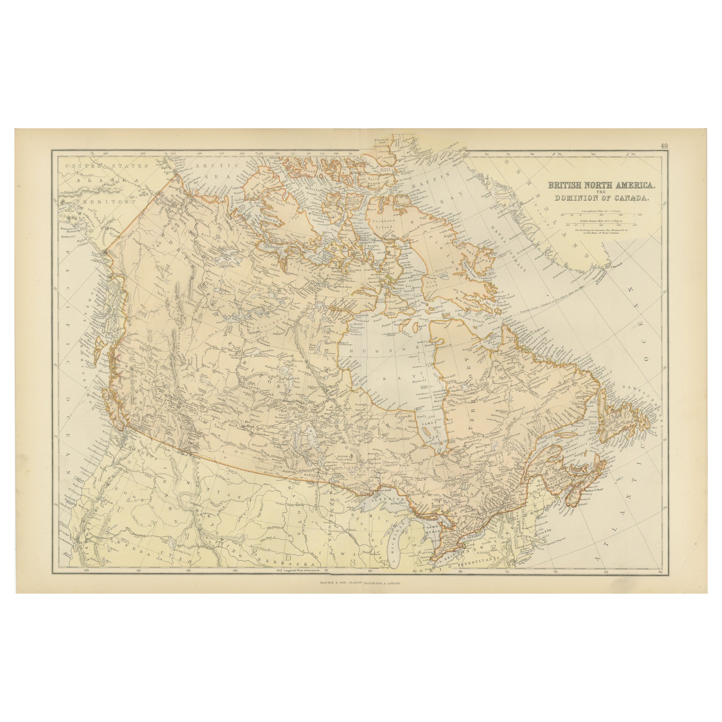
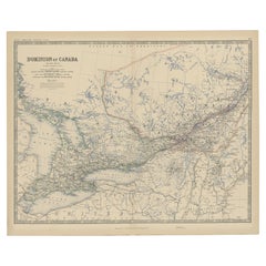
- Old Original Antique Map of Western Canada, 1882Located in Langweer, NLAntique map titled 'Dominion of Canada'. Old map of Western Canada. This map originates from 'The Royal Atlas of Modern Geography, Exhibiting, in a ...Category
Antique 1880s Maps
MaterialsPaper
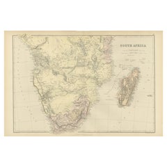
- Antique Decorative Coloured Map of South Africa and Madagascar, 1882Located in Langweer, NLThe map of South Africa is from the Blackie & Son Atlas, published in 1882. This historical map is quite interesting for several reasons: 1. **Historical Period**: This map was crea...Category
Antique 1880s Maps
MaterialsPaper
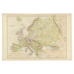
- Colorful Detailed Antique Map of Europe, Published in 1882Located in Langweer, NL"The Antique Map of Europe from 'The Comprehensive Atlas and Geography of the World,' published in 1882 by Blackie & Son, is a testament to meticulous cartography and scholarly preci...Category
Antique 1880s Maps
MaterialsPaper
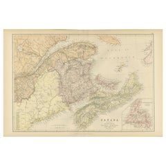
- Decorative Antique Map of Eastern Canada, Published in 1882Located in Langweer, NLThis is a historical map from the 1882 Blackie Atlas, focused on eastern Canada and the maritime provinces. The map is titled "Canada. No. 2. Provinces of Nova Scotia, New Brunswick,...Category
Antique 1880s Maps
MaterialsPaper
- Uncoulored Original Antique Map of Western Africa, 1749Located in Langweer, NLInteresting detailed German antique map titled 'Neue Vorstellung der Abendlaendischen Küsten von Africa (..)'. Original antique map of Western Africa. This map originates from 'Neue ...Category
Antique Mid-18th Century Maps
MaterialsPaper
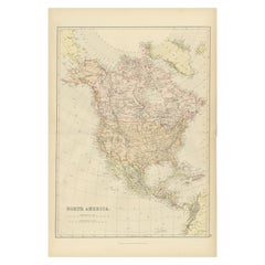
- Antique Decorative Coloured Map of North America, 1882Located in Langweer, NLThis original antique map of North America is from the Blackie & Son Atlas published in 1882. Here are several points of interest about this map: 1. **Political Borders**: The map l...Category
Antique 1880s Maps
MaterialsPaper

You May Also Like
- London 1744 Published Watercolour Antique Map of East Africa by Eman BowenLocated in GBWe are delighted to offer for sale this New and Accurate Map of Nubia & Abissinia, together with all the Kingdoms Tributary Thereto, and bordering upon them published in 1744 by Emanuel Bowen This is a decorative antique engraved map of East Africa...Category
Antique 1740s English George III Maps
MaterialsPaper
- Antique Oarsman's Map of the River Thames, English, Cartography, Published 1912Located in Hele, Devon, GBThis is an antique copy of The Oarsman's and Angler's Map of the River Thames - New Edition. An English, bound map book, published in English by Edward Stanford, London, this new edi...Category
Early 20th Century British Other Books
MaterialsPaper
- Antique Paterson's Guide to Britain, English, Maps, Georgian, Published 1811Located in Hele, Devon, GBThis is an antique copy of Paterson's New and Accurate guide to Direct & Principal Crossroads. An English, bound book of maps and descriptive tables, published in English by Longman,...Category
Antique Early 19th Century British Georgian Books
MaterialsPaper
- Antique Lithography Map, Western Russia, English, Framed, Cartography, VictorianLocated in Hele, Devon, GBThis is an antique lithography map of Western Russia. An English, framed atlas engraving of cartographic interest by John Rapkin, dating to the early Victorian period and later, circ...Category
Antique Mid-19th Century British Early Victorian Maps
MaterialsWood
- Vintage World Map Mirror Based on the Original by Johnson 1882 Military CampaignLocated in GBWe are delighted to offer for sale this lovely Antique style pictorial plan map of the globe based on the original by Johnson in 1882 This is a very interesting and decorative pie...Category
20th Century English Campaign Maps
MaterialsMirror
- 1840 Map of the City of Washington Published by William M. MorrisonLocated in Colorado Springs, COThis map, printed in 1840, is a detailed representation of Washington, D.C. in the mid-19th century. The map shows block numbers, wards, and government buildings as well as details o...Category
Antique 1840s American Federal Maps
MaterialsPaper