Items Similar to 1840 Map of the City of Washington Published by William M. Morrison


Want more images or videos?
Request additional images or videos from the seller
1 of 8
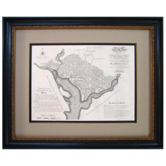
1840 Map of the City of Washington Published by William M. Morrison
About the Item
This map, printed in 1840, is a detailed representation of Washington, D.C. in the mid-19th century. The map shows block numbers, wards, and government buildings as well as details of the city that have since changed. The map was published by William M. Morrison, drawn by F. C. De Kraft, the City Surveyor, and engraved by "Mrs. W. L. Stone.”
With the Capitol Building at the center, this map closely resembles the 1792 Plan of D.C. by Ellicott. Different from later maps, this work does not include Georgetown or Georgetown College and refers to the Anacostia River only as the “Eastern Branch.” In the middle of a massive construction push, the area was rapidly changing as the young city attempted to not only establish capitol-worthy structures, but also reconstruct what the British had destroyed in the recent War of 1812. The southwest edge of the city looks very different from today. Most notably, this 1840 map was printed before the plans for the harbor improvement plans were made, leaving the Potomac River edge coming right up near the White House. Additionally, at the time of publishing, the canals running from the mall and flowing through the city to end at the Green Leaf Terminus or the Navy Yard Terminus were still functional. It wasn’t until the 1870s when the destruction of these canals began.
Based on the design by L’Enfant and Ellicott, the plan for the city of Washington was closely adhered to once their plan was put into place. This map shows the city as it was only 40 years after the presidents first began living in the city. With the broad avenues and large public squares, the grandiosity of the young country’s capital reflected its hopes for the future.
CONDITION:
The map is wrinkled and creased with small tears throughout from use. The top left corner of the map has a small loss, but no parts of the city are missing and the map has been backed with canvas. The 1840 map has a few stains from old age and has “Washington” written at the top in pencil from a previous owner.
"Map of the City of Washington" Published by William M. Morrison, 1840. Drawn by F. C. De Kraft, City Surveyer. Engraved by "Mrs. W. L. Stone.”
There are two chips in the frame, but the frame is archival quality and includes UV protective glass. Framed Dimensions: 24.75” H x 29.5” W x 1.5” D.
- Dimensions:Height: 24.75 in (62.87 cm)Width: 29.5 in (74.93 cm)Depth: 1.5 in (3.81 cm)
- Style:Federal (In the Style Of)
- Materials and Techniques:Paper,Engraved
- Place of Origin:
- Period:
- Date of Manufacture:1840
- Condition:Additions or alterations made to the original: Framed by Art Source International Framing in Boulder, Colorado in March of 2016. Wear consistent with age and use. Minor losses. Minor structural damages. Minor fading.
- Seller Location:Colorado Springs, CO
- Reference Number:
About the Seller
4.9
Platinum Seller
These expertly vetted sellers are 1stDibs' most experienced sellers and are rated highest by our customers.
Established in 2010
1stDibs seller since 2011
400 sales on 1stDibs
Typical response time: <1 hour
- ShippingRetrieving quote...Ships From: Colorado Springs, CO
- Return PolicyA return for this item may be initiated within 10 days of delivery.
More From This SellerView All
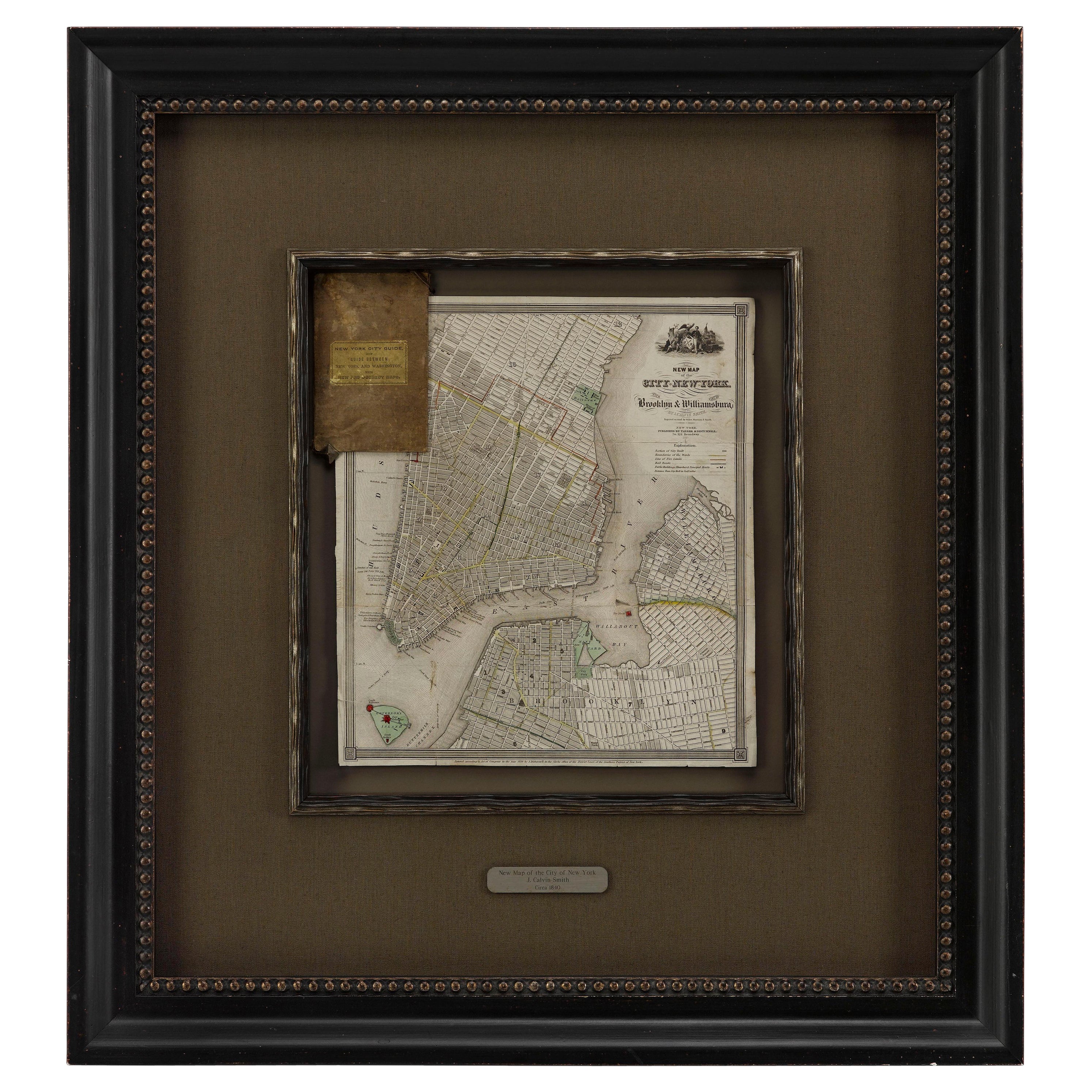
- 1840 "New Map of the City of New York With Part of Brooklyn & Williamsburg"Located in Colorado Springs, COPresented is a hand-colored, engraved folding map titled "New Map of the City of New York With Part of Brooklyn & Williamsburg" by J. Calvin Smith. The map was issued bound in the bo...Category
Antique 1840s American Maps
MaterialsPaper
- 1842 Wall Map of the United States by J. H. Young, Published by S. A. MitchellLocated in Colorado Springs, COPresented is an 1842 hanging “Map of the United States,” engraved by J. H. Young and published by Samuel Augustus Mitchell, Philadelphia. This is a beautiful example of the rare 1842...Category
Antique 1840s American Maps
MaterialsPaper
- Plan for the City of Washington by Andrew Ellicott, Antique Print, 19th CenturyLocated in Colorado Springs, COBy Andrew Ellicott (1754-1820) and Pierre Charles L'Enfant (1754-1825). Plan of the City of Washington. Published by Thackara & Vallance, Philadelphia, 1792. Later impression printed on 19th century wove paper. This is a fine 19th century printing of the "official" plan of Washington, D.C. First printed in 1792 by the original publishers, Thackara & Vallance in Philadelphia, this is a later 19th century printing of the fifth recorded engraving of the L’Enfant / Ellicott city plan. The first three issues of this city plan were in published in periodicals, making the fifth edition only the second separately-issued engraving of the plan. In full, the title reads, “Plan of the City of Washington in the Territory of Columbia, ceded by the States of Virginia and Maryland to the United States of America and by them established as the Seat of their Government after the year 1800.” The national capital city is laid out according to a plan originally proposed by Pierre Charles L'Enfant and modified by Andrew Ellicott. L'Enfant was born in Paris, where he trained to be an architect. He came to America in 1777, and served under George Washington as an engineer during the Revolutionary War. In 1791, Washington asked L'Enfant to design the new capital city in the District of Columbia. However, trouble arose between the city and L'Enfant. The City Commissioner needed a finished, printed copy of the plan in order to sell building lots but L'Enfant worked slowly and released only incomplete plans, and proved to be quite obstinate. On instruction from President Washington...Category
Antique Late 19th Century American Maps
MaterialsPaper
- 1861 Topographical Map of the District of Columbia, by Boschke, Antique MapLocated in Colorado Springs, COPresented is an original map of Albert Boschke's extremely sought-after "Topographical Map of the District of Columbia Surveyed in the Years 1856 ...Category
Antique 1860s American Historical Memorabilia
MaterialsPaper
- "Clason's Guide Map of Montana" by The Clason Map Company, Circa 1920sLocated in Colorado Springs, COPresented is “Clason's Guide Map of Montana,” published in the early 1920s by the Clason Map Company. Issued as a folding map, this map identifies county boundaries, county seats, Na...Category
Vintage 1920s American Art Deco Maps
MaterialsPaper
- 1908 "Map of Texas" by The Kenyon CompanyLocated in Colorado Springs, COPresented is an antique map of the state of Texas, printed as a pocket map in 1908 by The Kenyon Company. The state map is brightly colored by county, with principal cities and towns listed. The congressional districts are numbered and boldly outlined in red. Rivers, roads, and railroads all appear prominently on this fantastic map...Category
Antique Early 1900s American Maps
MaterialsPaper


You May Also Like
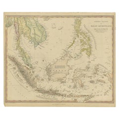
- Antique Map of the East Indies by Walker, c.1840Located in Langweer, NLOriginal antique map of the East Indies including Borneo, Celebes, Java, Sumatra and surrounding islands. Published circa 1840. Artists and Engravers: Engraved by J. & C. Walker ...Category
Antique 19th Century Maps
MaterialsPaper
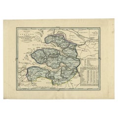
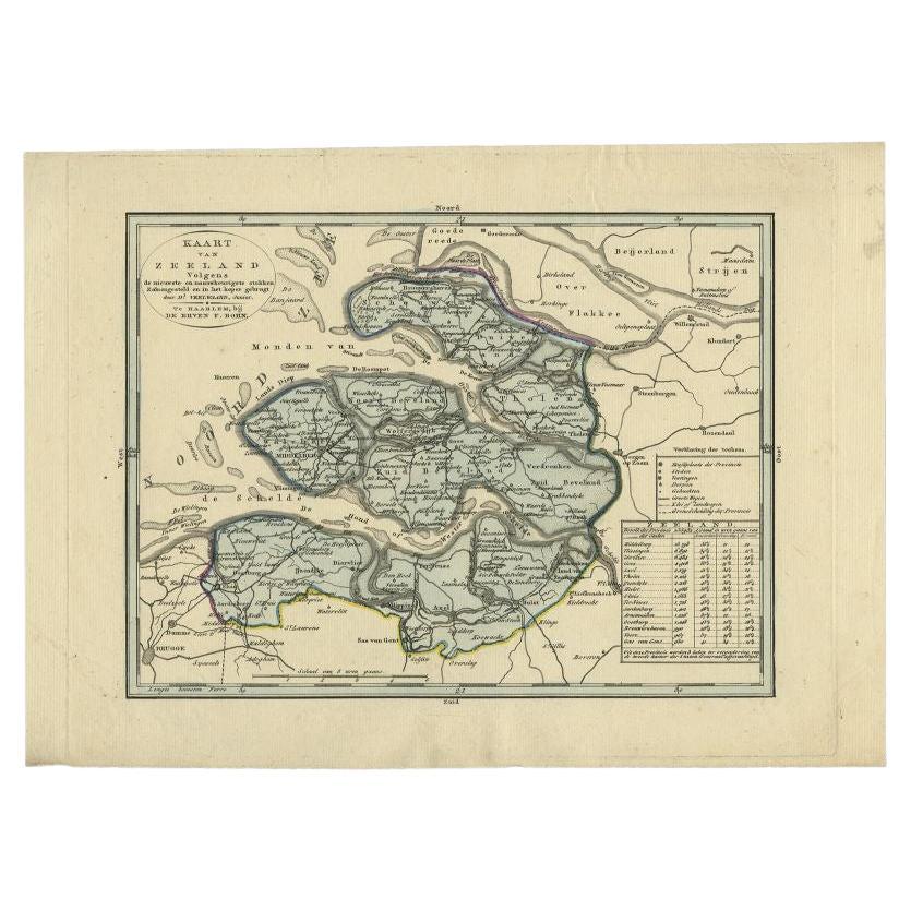
- Antique Map of the Province of Zeeland by Veelwaard, C.1840Located in Langweer, NLAntique map titled 'Kaart van Zeeland (..).' Uncommon map showing the province of Zeeland in the Netherlands. Source unkown, to be determined. Published circa 1840. Artists and E...Category
Antique 19th Century Maps
MaterialsPaper
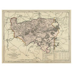
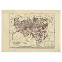
- Antique Map of the Region of Henegouwen by Veelwaard, C.1840Located in Langweer, NLAntique map titled 'Kaart van Henegouwen'. Original antique map of the region of Henegouwen (Hainaut), Belgium. Source unkown, to be determined. Published circa 1840. Artists and...Category
Antique 19th Century Maps
MaterialsPaper
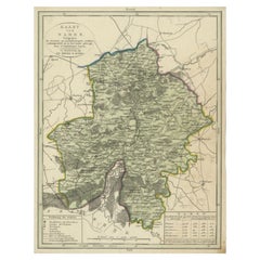
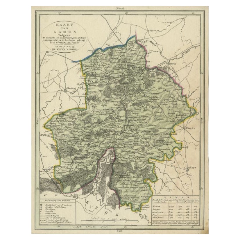
- Antique Map of the Region of Namen by Veelwaard, c.1840Located in Langweer, NLAntique map titled 'Kaart van Namen'. Original antique map of the region of Namen (Namur), Belgium. Source unkown, to be determined. Published circa 1840. Artists and Engravers:...Category
Antique 19th Century Maps
MaterialsPaper
- Antique Map of the Region of Luik by Veelwaard, C.1840Located in Langweer, NLAntique map titled 'Kaart van Luik'. Original antique map of the region of Luik (Liege), Belgium. Source unkown, to be determined. Published circa 1840. Artists and Engravers: E...Category
Antique 19th Century Maps
MaterialsPaper
- Antique Map of the Region of Luik by Veelwaard, c.1840Located in Langweer, NLAntique map titled 'Kaart van Luik'. Original antique map of the region of Luik (Liege), Belgium. Source unkown, to be determined. Published circa 1840. Artists and Engravers: E...Category
Antique 19th Century Maps
MaterialsPaper