Items Similar to Plan for the City of Washington by Andrew Ellicott, Antique Print, 19th Century

Want more images or videos?
Request additional images or videos from the seller
1 of 6
Plan for the City of Washington by Andrew Ellicott, Antique Print, 19th Century
About the Item
By Andrew Ellicott (1754-1820) and Pierre Charles L'Enfant (1754-1825). Plan of the City of Washington. Published by Thackara & Vallance, Philadelphia, 1792. Later impression printed on 19th century wove paper.
This is a fine 19th century printing of the "official" plan of Washington, D.C. First printed in 1792 by the original publishers, Thackara & Vallance in Philadelphia, this is a later 19th century printing of the fifth recorded engraving of the L’Enfant / Ellicott city plan. The first three issues of this city plan were in published in periodicals, making the fifth edition only the second separately-issued engraving of the plan. In full, the title reads, “Plan of the City of Washington in the Territory of Columbia, ceded by the States of Virginia and Maryland to the United States of America and by them established as the Seat of their Government after the year 1800.”
The national capital city is laid out according to a plan originally proposed by Pierre Charles L'Enfant and modified by Andrew Ellicott. L'Enfant was born in Paris, where he trained to be an architect. He came to America in 1777, and served under George Washington as an engineer during the Revolutionary War. In 1791, Washington asked L'Enfant to design the new capital city in the District of Columbia. However, trouble arose between the city and L'Enfant. The City Commissioner needed a finished, printed copy of the plan in order to sell building lots but L'Enfant worked slowly and released only incomplete plans, and proved to be quite obstinate. On instruction from President Washington, Thomas Jefferson on February 27, 1792 wrote a letter to L'Enfant dismissing him as city planner and assigned Andrew Ellicot the project. Trained as a mathematician and surveyor, Ellicott had previously conducted a full survey of the city in 1791, and was an obvious pick for L'Enfant's replacement. Ellicott made several changes to L'Enfant's original plan including the alignment of Massachusetts Avenue, reworked some short radial avenues, and named the streets. A few months later Ellicott, like L'Enfant, found himself at odds with the Commissioners and resigned from the project.
The authority to establish a federal capital was provided in Article One, Section 8, of the United States Constitution, which permits a "District (not exceeding ten miles square) as may, by cession of particular states, and the acceptance of Congress, become the seat of the government of the United States." James Madison explained the need for a federal district on January 23, 1788 in the Federalist No. 43, arguing that the national capital needed to be distinct from the states, in order to provide for its own maintenance and safety. The Constitution, however, does not specify a location for the new capital. In what later became known as the Compromise of 1790, Madison, Alexander Hamilton, and Thomas Jefferson came to an agreement that the federal government would assume war debt carried by the states, on the condition that the new national capital would be located in the South. On July 16, 1790, the Residence Act provided for a new permanent capital to be located on the Potomac River, the exact area to be selected by President Washington. Both Maryland and Virginia ceded portions of their territory to form the new capital, and a new 'federal city' was constructed on the north bank of the Potomac. On September 9, 1791, the federal city was named in honor of George Washington and the district was named the Territory of Columbia.
CONDITION:
Overall very good condition. This early 19th century print of the original plan of the city of Washington is printed on 19th century wove paper. The map has one faintly discolored area to the left of the “Breadth of Streets” description, however, it does not detract from the overall appearance. Otherwise, it exhibits no evidence of damage. The map has been beautifully framed according to archival standards with acid-free matting and UV protective glass.
- Dimensions:Height: 36 in (91.44 cm)Width: 43.75 in (111.13 cm)Depth: 3 in (7.62 cm)
- Materials and Techniques:
- Place of Origin:
- Period:
- Date of Manufacture:1850-1890
- Condition:Wear consistent with age and use.
- Seller Location:Colorado Springs, CO
- Reference Number:
About the Seller
4.9
Platinum Seller
These expertly vetted sellers are 1stDibs' most experienced sellers and are rated highest by our customers.
Established in 2010
1stDibs seller since 2011
400 sales on 1stDibs
Typical response time: <1 hour
- ShippingRetrieving quote...Ships From: Colorado Springs, CO
- Return PolicyA return for this item may be initiated within 10 days of delivery.
More From This SellerView All
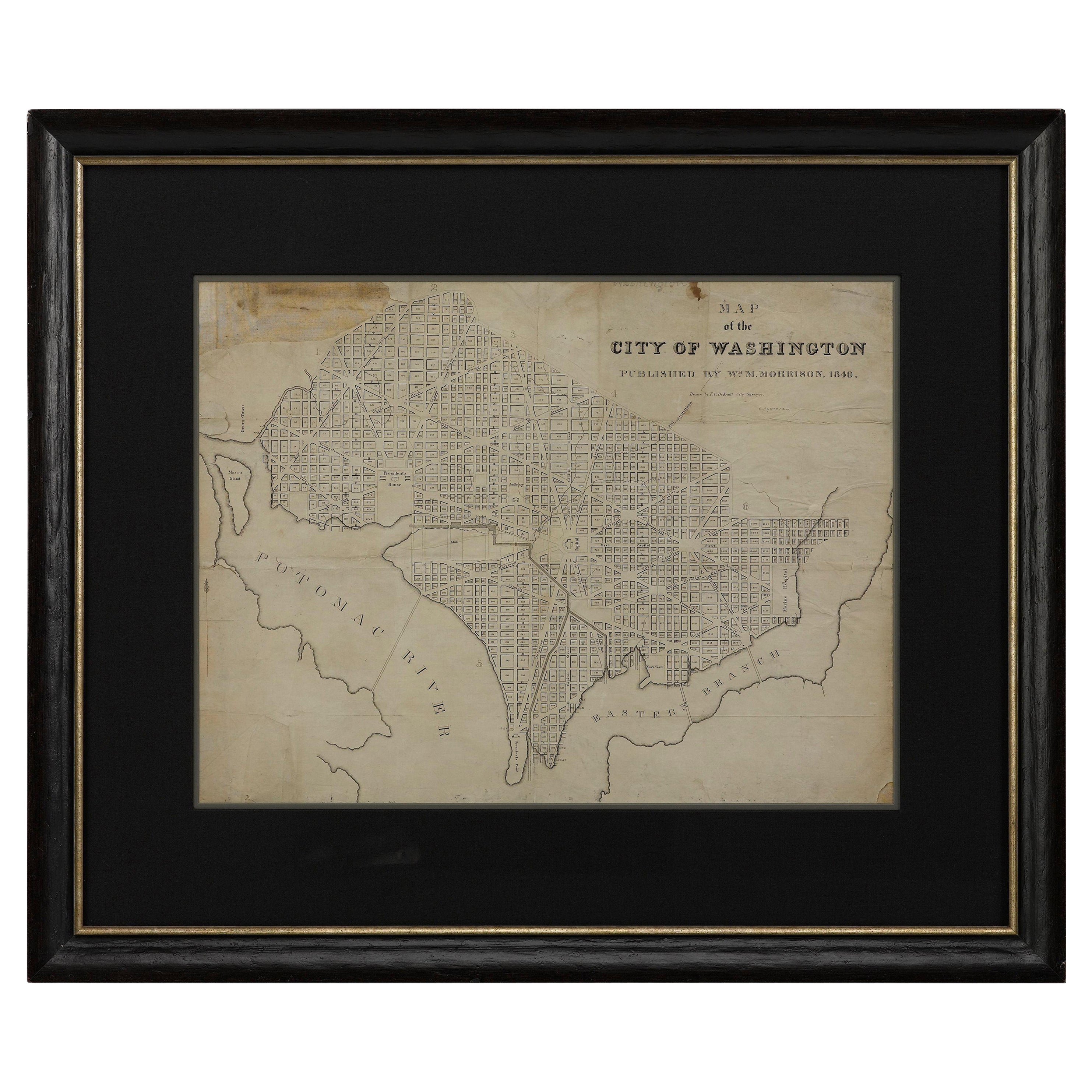
- 1840 Map of the City of Washington Published by William M. MorrisonLocated in Colorado Springs, COThis map, printed in 1840, is a detailed representation of Washington, D.C. in the mid-19th century. The map shows block numbers, wards, and government buildings as well as details o...Category
Antique 1840s American Federal Maps
MaterialsPaper
- "Lady Washington's Reception, " Engraved by A. H. Ritchie, Antique Print, 1865Located in Colorado Springs, COThis 1865, hand-colored engraving by A. H. Ritchie is entitled Lady Washington's Reception and is based on Daniel F. Huntington's original painting "Th...Category
Antique 1860s American Prints
MaterialsPaper
- N.E. View of the United States Capitol, Washington, DC Antique Proof Print 1858Located in Colorado Springs, COThis engraved print shows a view of the United States Capitol Building, in Washington, D.C. The print depicts the neoclassical building from the northeast orientation, with a bustling street scene in front. The steel engraving is a proof printing, drawn and engraved by Henry Sartain and published in 1858. Plans began in May 1854 to build a new cast-iron dome for the United States Capitol. The then-architect of the Capitol Thomas Walter and his team were sold on the aesthetics of a new dome, as well as the utility of a fire-proof one. A year later, on March 3, 1855, President Franklin Pierce...Category
Antique 1850s American Prints
MaterialsPaper
- Antique Brass Three-Draw Telescope, 19th CenturyLocated in Colorado Springs, COThis antique three-draw telescope dates to the 19th century. Solidly crafted with brass draws and a brass barrel wrapped in leather, this antique telescope is a beautiful example of ...Category
Antique 19th Century French Scientific Instruments
MaterialsBrass
- Plan of Paris, France, by A. Vuillemin, Antique Map, 1845Located in Colorado Springs, COThis large and detailed plan of Paris was published by Alexandre Vuillemin in 1845. The map conveys a wonderful amount of information and is decorated throughout with pictorial vigne...Category
Antique 1840s American Maps
MaterialsPaper
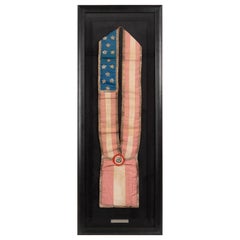
- Antique 13-Star Patriotic Sash by Louis E. Stilz & Bros., Late 19th CenturyLocated in Colorado Springs, COPresented is an original patriotic sash from the late 19th century, featuring 13 stars against a bright blue field. This sash features appliqued silver stars on a blue canton, red an...Category
Antique Late 19th Century American Historical Memorabilia
MaterialsCotton


You May Also Like
- Antique Plan of the City of Bayonne, FranceLocated in Langweer, NLAntique map titled 'Plan de Bayonne'. Original old plan of the city of Bayonne, France. This map originates from 'Le Petit Atlas Maritime (..)' by J.N. Bellin. Published 1764. Be...Category
Antique Mid-18th Century Maps
MaterialsPaper
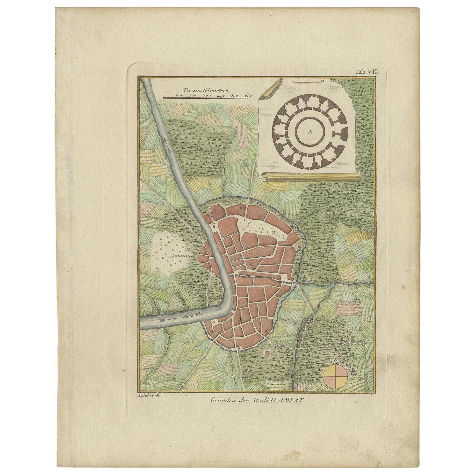
- Antique Plan of the City of Damietta Egypt by C. Niebuhr, 1774Located in Langweer, NLAntique print titled 'Grundris der Stadt Damiât'. This print originates from 'Reisebeschreibung nach Arabien und andern umliegenden Ländern' by C. Niebuhr, 1774.Category
Antique Late 18th Century Prints
MaterialsPaper
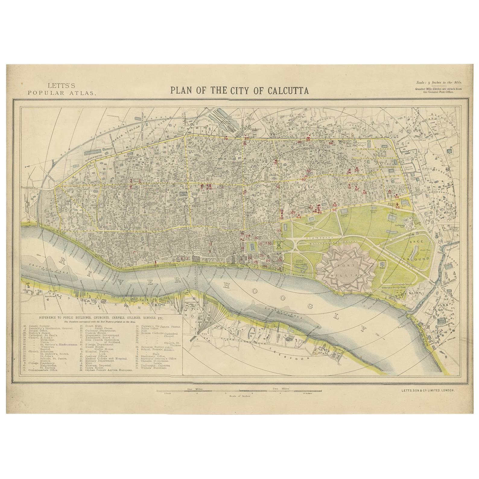
- Antique Plan of the City of Calcutta 'India' by Letts, 1883Located in Langweer, NLBeautiful colored plan showing buildings (with key), Fort William, race ground, canals, railroads, etc. This plan originates from Letts's Popular Atlas.Category
Antique Late 19th Century Maps
MaterialsPaper
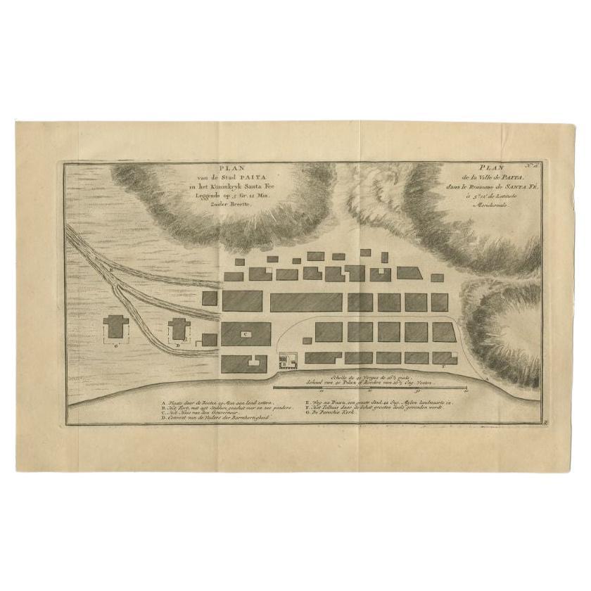
- Antique Plan of the City of Paita in Peru, by Anson, 1749Located in Langweer, NLAntique map titled 'Plan van de Stad Paita in het Koninkryk Santa Fee (..) - Plan de la Ville de Paita (..)'. Original antique plan of the city of Paita, Peru. This map originates fr...Category
Antique 18th Century Maps
MaterialsPaper
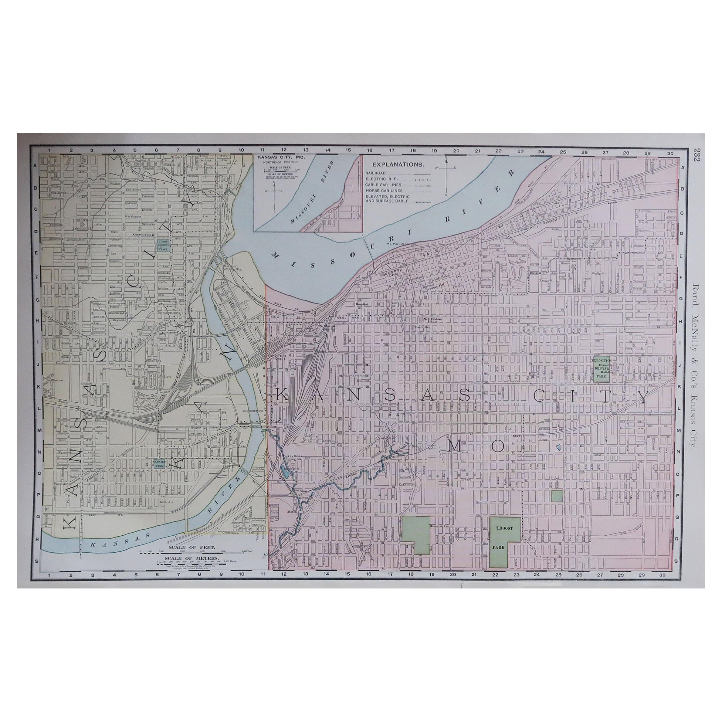
- Original Antique City Plan of Kansas City, USA. 1894By Rand McNally & Co.Located in St Annes, LancashireFabulous colorful map of Kansas City Original color By Rand, McNally & Co. Published, 1894 Unframed Slightly reduced bottom margin. Free shipping.Category
Antique 1890s American Maps
MaterialsPaper
- Original Antique City Plan of Milwaukee, USA, 1894By Rand McNally & Co.Located in St Annes, LancashireFabulous colorful map of Milwaukee Original color By Rand, McNally & Co. Published, 1894 Unframed Free shipping.Category
Antique 1890s American Maps
MaterialsPaper


Recently Viewed
View AllMore Ways To Browse
Used Furniture Washington
D Plan
South Street Antiques
Antique Furniture Washington
Architect Plan
Washington Glass
Washington Antiques
Late 19th C American Furniture
American Federal Antiques
American Antique Federal Furniture
Massachusetts Antiques
Virginia 19th Century
Antique Furniture In Virginia
1790 America
American Impression Furniture
1825 American
Antique Furniture Hamilton
Antique Furniture Hamilton Furniture