Items Similar to 1908 "Map of Texas" by The Kenyon Company


Video Loading
Want more images or videos?
Request additional images or videos from the seller
1 of 8
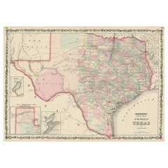
1908 "Map of Texas" by The Kenyon Company
About the Item
Presented is an antique map of the state of Texas, printed as a pocket map in 1908 by The Kenyon Company. The state map is brightly colored by county, with principal cities and towns listed. The congressional districts are numbered and boldly outlined in red. Rivers, roads, and railroads all appear prominently on this fantastic map. Although uncolored, the bordering states of New Mexico, Oklahoma, Arkansas, and Louisiana, as well as Mexico, are likewise marked with significant cities, towns, roads, and rivers. Incredibly informative, the reverse side of the map contains population statistics for all principal cities and towns shown on the map.
The map was issued as an advertisement for the Royal Land Company, Incorporated, to entice the purchase of land in Dalhart, Texas. To that end, a stylized pointing hand is overprinted in red ink at the top right of the map, encouraging viewers to “Get A Home In Texas.” The hand is pointing to a red circle over Dalhart, Texas, identifying the newly founded city on the map. At the bottom right, the map further invites viewers to: "Go with us to Dalhart, Texas. We run excursions on the First and Third Tuesday of each month. Inquire of your station agent at once for rates. Join our Train at Kansas City. FREE BERTHS."
The original settlement for Dalhart was platted in early 1901 by W. J. Blair and Charles W. Thornton where the Chicago, Rock Island and Pacific Railway crossed the Fort Worth and Denver City line. The site of the crossing was known for a time as Twist Junction. Later the settlement was named Denrock, a combination of the names of the two railroads. After objection from the postal service, the town adopted the name of Dalhart, a portmanteau of the two county names- Dallham and Hartley- it sat on the border of. On June 11, 1901, Ora D. Atkinson and other promoters incorporated the Dalhart Town Company, and the first sale of lots was held on July 20. Dalhart was incorporated as a town in May of 1902 and as a city in April of 1904.
Dalhart quickly grew as a shipping center for the famous XIT Ranch and other area ranches. The activities of prominent land companies, like Royal Land Company and the W. P. Soash Land Company, also contributed significantly to Dalhart's progress. In the early 20th century, these town promoters and land agents used railroad excursion trains to introduce potential settlers and farmers from the Midwest to available property in northwest Texas. They would advertise bi-weekly train excursions from popular train junctions in order to give potential buyers an opportunity and means to visit available land. They would sometimes offer reduced ticket fares or even free berths (as seen on this map) to further entice interested parties. The land companies would use printed posters, informational and salesy pamphlets, and colorful maps to promote their land sales.
CONDITION:
Very good condition. Printed colored map, on thin issued paper. Fold lines present, as expected. Paper is healthy, save very minor wrinkling along paper’s margins and light toning overall.
The map’s title is printed in black at bottom right: “MAP OF TEXAS, With Population and Location of Principal Towns and Cities according to latest reliable statistics/ The Red lines show Congressional Districts./ FOR STATISTICS SEE BACK OF MAP./ Copyrighted 1908. The Kenyon Company, Map Makers, Des Moines, Iowa.” The map is overprinted in red at top left: “Royal Land Company (Incorporated) 201-2-3-4 Commercial Bldg, Des Moines, Iowa.” At top right, "Get a Home in Texas,” is overprinted inside a red pointing hand. The city of Dalhart, Texas is encircled in red. Overprinted in red ink at bottom left: "Go with us to Dalhart, Texas, We run excursions on the First and Third Tuesday of each month. Inquire of your station agent at once for rates. Join our Train at Kansas City. FREE BERTHS."
The map is artfully framed to archival standards, with acid-free mats and backing, UV glass, and a custom-built black wooden frame.
Framed Dimensions: 24" H x 26" W x 1 1/8" D.
- Dimensions:Height: 24 in (60.96 cm)Width: 26 in (66.04 cm)Depth: 1.5 in (3.81 cm)
- Materials and Techniques:
- Place of Origin:
- Period:1900-1909
- Date of Manufacture:1908
- Condition:Additions or alterations made to the original: Archival framing by Rio Grande Custom Framing in Boulder, Colorado, in April of 2023. Wear consistent with age and use. Minor fading.
- Seller Location:Colorado Springs, CO
- Reference Number:
About the Seller
4.9
Platinum Seller
These expertly vetted sellers are 1stDibs' most experienced sellers and are rated highest by our customers.
Established in 2010
1stDibs seller since 2011
400 sales on 1stDibs
Typical response time: <1 hour
- ShippingRetrieving quote...Ships From: Colorado Springs, CO
- Return PolicyA return for this item may be initiated within 10 days of delivery.
More From This SellerView All
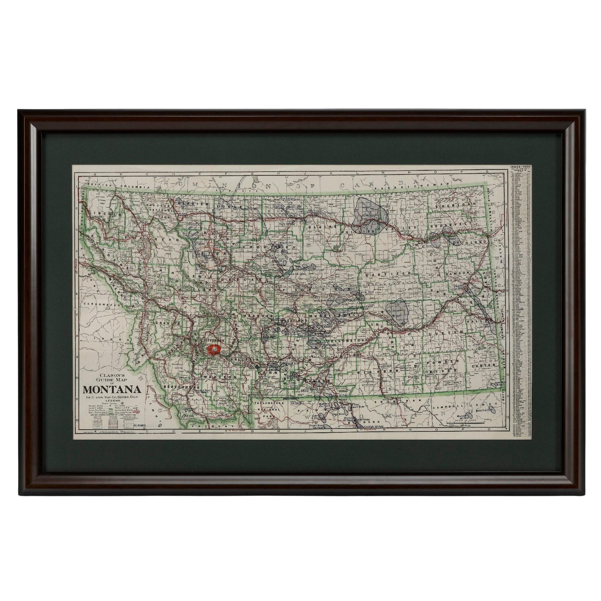
- "Clason's Guide Map of Montana" by The Clason Map Company, Circa 1920sLocated in Colorado Springs, COPresented is “Clason's Guide Map of Montana,” published in the early 1920s by the Clason Map Company. Issued as a folding map, this map identifies county boundaries, county seats, Na...Category
Vintage 1920s American Art Deco Maps
MaterialsPaper
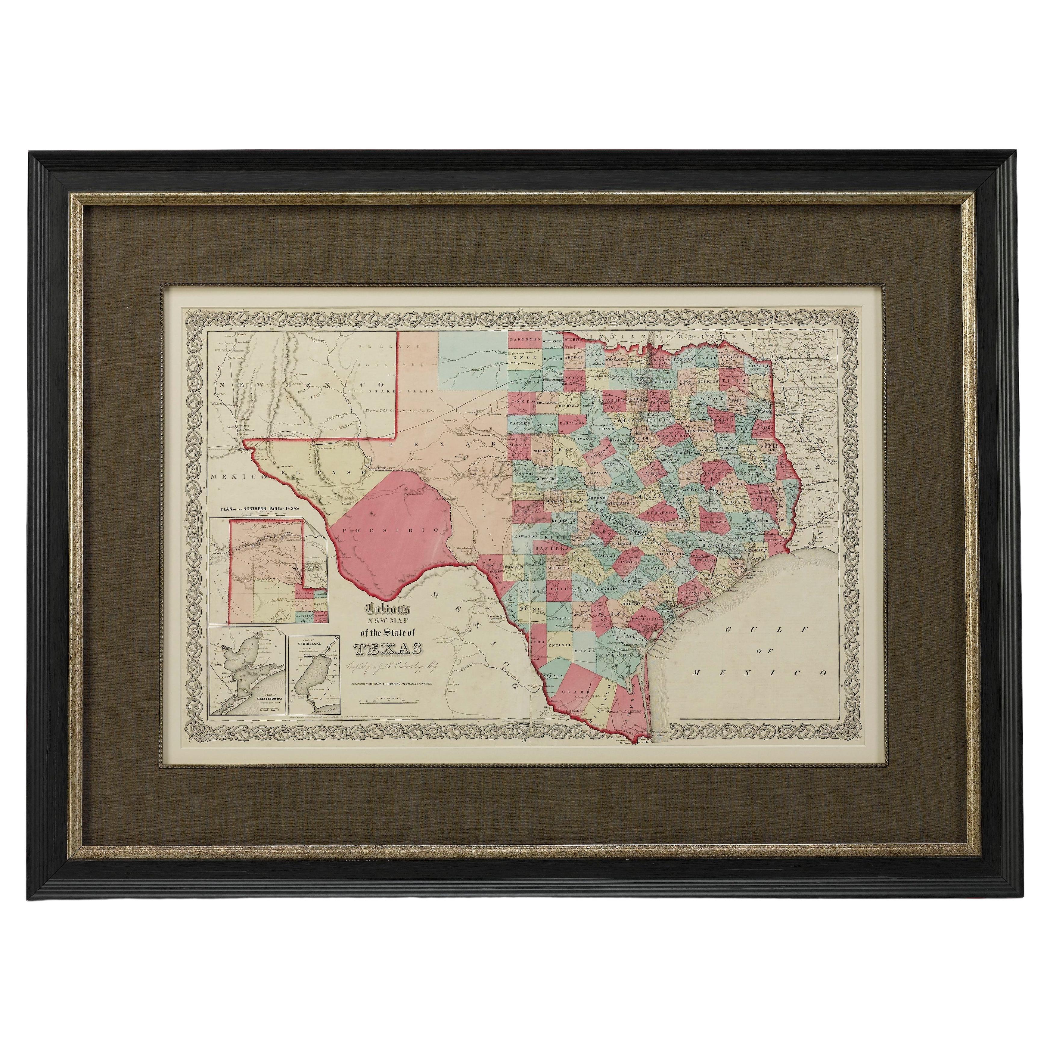
- 1859 "Colton's New Map of the State of Texas..." by Johnson & BrowningLocated in Colorado Springs, COPresented is "Colton's New Map of the State of Texas Compiled from De Cordova's Large Map", published in Alivin J. Johnson’s “New Illustrated Family Atlas.” The map was published in ...Category
Antique 1850s American Maps
MaterialsPaper
- 1847 Antique Map of Mexico, Texas and California by Samuel Augustus MitchellBy Samuel Augustus Mitchell 1Located in Colorado Springs, COPresented is the second edition of Samuel Augustus Mitchell's Map of Mexico, Including Yucatan & Upper California, an important map showing the progress of the Mexican-American War. ...Category
Antique 1840s American Maps
MaterialsPaper
- 1861 Topographical Map of the District of Columbia, by Boschke, Antique MapLocated in Colorado Springs, COPresented is an original map of Albert Boschke's extremely sought-after "Topographical Map of the District of Columbia Surveyed in the Years 1856 ...Category
Antique 1860s American Historical Memorabilia
MaterialsPaper
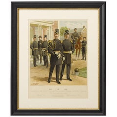
- Original "1902-1907 Officers of the Staff Corps" by C. Ogden, 1908Located in Colorado Springs, CO1908 "1902-1907 Officers of the Staff Corps & Departments, General Staff and Chaplain in Full Dress" Chromolithograph by C. Ogden This colorful lithograph by H. A. Ogden was publish...Category
Antique Early 1900s American Prints
MaterialsPaper
- 1859 "Map of the United States of America..." by J. H. ColtonBy J.H. ColtonLocated in Colorado Springs, COPresented is an 1859 “Map of the United States of America, the British Provinces, Mexico, the West Indies and Central America with Part of...Category
Antique 1850s American Maps
MaterialsPaper


You May Also Like
- Antique Map of the Eastern United States with Inset Map of TexasLocated in Langweer, NLAntique map titled 'Verein-Staaten von Nord-America mit Ausnahme Florida's und der Westlichen Territorien'. This map extends as far west as Louisiana and only includes the northern p...Category
Antique Mid-19th Century Maps
MaterialsPaper
- Large Antique Map of the State of Texas, 1861Located in Langweer, NLAntique map titled 'Johnson's New Map of the State of Texas' Large map of Texas, shows railroads, wagon roads, the U.S. Mail Route, rivers, ports, ...Category
Antique Mid-19th Century Maps
MaterialsPaper
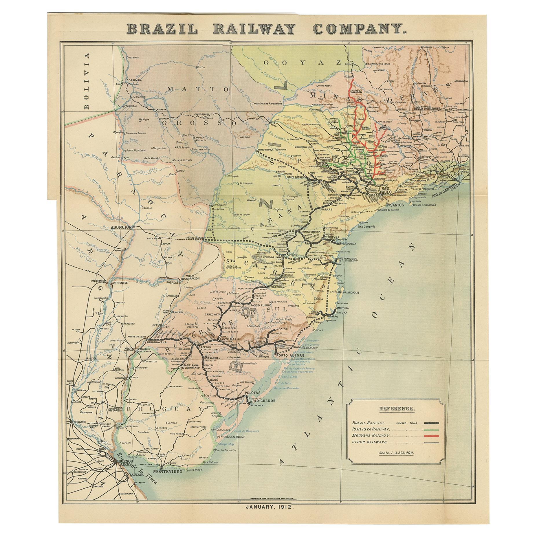
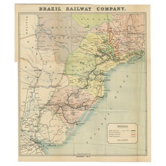
- Antique Map of the Brazil Railway Company, '1912'Located in Langweer, NLAntique map titled 'Brazil Railway Company'. This folding map is attached to the booklet titled 'The Brazil Railway Company'. It is a memorandum by A. H. A. Knox-Little, who was the ...Category
Early 20th Century Maps
MaterialsPaper
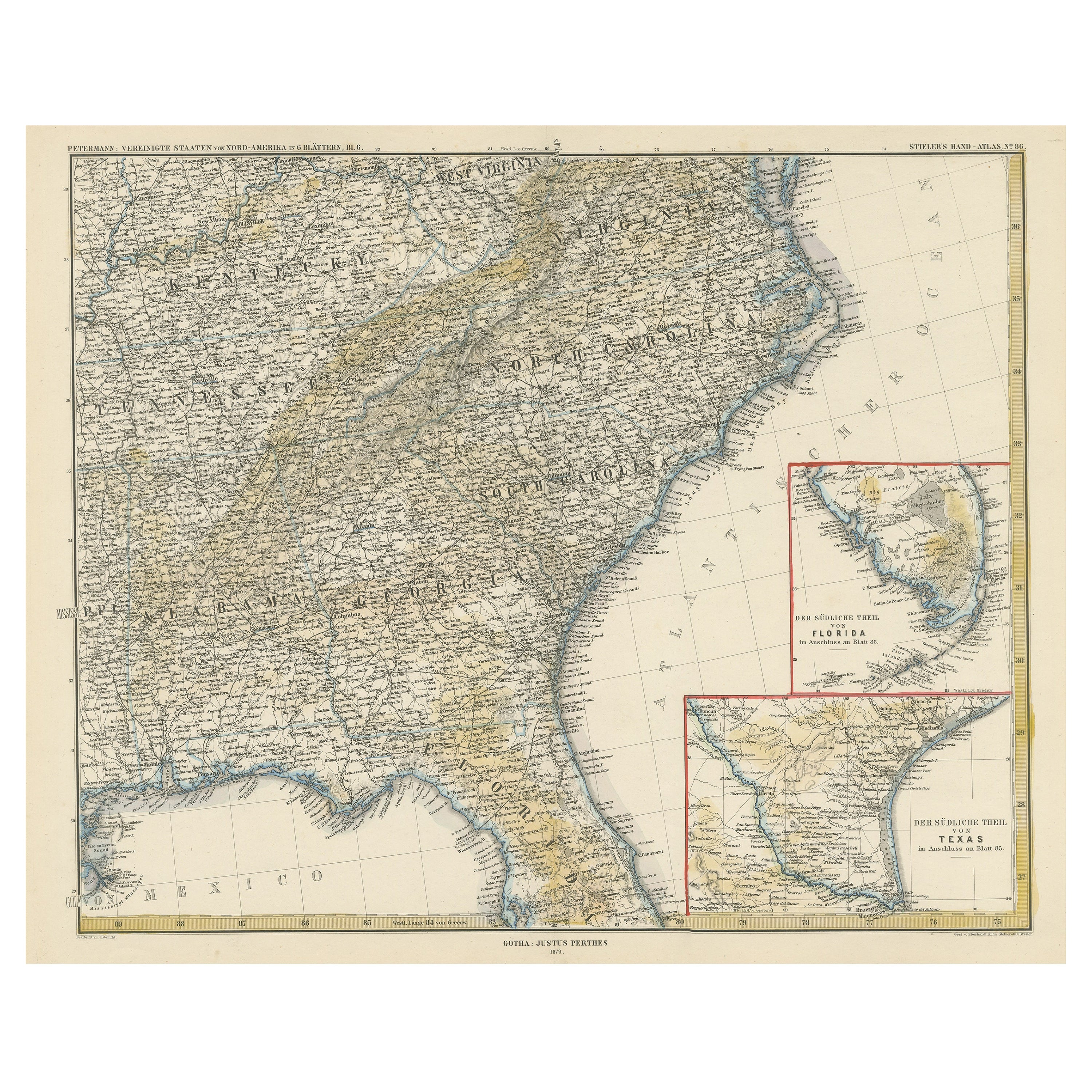
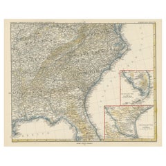
- Antique Map of the Region of Georgia with Inset Maps of Florida and TexasLocated in Langweer, NLAntique map of part of the United States showing Alabama, Georgia, North Carolina, South Carolina, Tennessee, Kentucky, Virginia and part of Florida. With inset maps of the southern ...Category
Antique Late 19th Century Maps
MaterialsPaper
- 1908 The Natural History of SelborneBy Gilbert WhiteLocated in Bath, GBA beautiful Riviere bound copy of this popular natural history work by ornithologist Gilbert White. An exceptionally bound work, with natural history motifs gilt tooled to the spine....Category
Antique Early 1900s British Books
MaterialsPaper
- Antique Map of the Islands of the Atlantic by J. TallisLocated in Langweer, NLA highly decorative and detailed mid-19th century map of the Islands of the Atlantic -- including the Azores, Madeira, Bermuda, the Canary Islands and the Cape Verde Islands -- which...Category
Antique Mid-19th Century Maps
MaterialsPaper


Recently Viewed
View AllMore Ways To Browse
Antique Companies
Antique Company
The Antique Company
Antique Furniture Company
Antique Furniture Companies
The Antique Furniture Company
Texan Furniture
Texas Furniture
Texas Used Furniture
Used Furniture In Texas
Antique Paper Company
Antique Furniture Sales
Wooden Train
Antique Agent
Antique Postal
Antique Postal Furniture
Antique Center Islands
Train Station Furniture