Items Similar to Colorful Detailed Antique Map of Europe, Published in 1882
Want more images or videos?
Request additional images or videos from the seller
1 of 6
Colorful Detailed Antique Map of Europe, Published in 1882
About the Item
"The Antique Map of Europe from 'The Comprehensive Atlas and Geography of the World,' published in 1882 by Blackie & Son, is a testament to meticulous cartography and scholarly precision. Crafted under the keen supervision of W.G. Blackie, Ph.D., and fellow of the Royal Geographical Society, this map stands as a relic of geographic mastery in the late 19th century.
With ornate borders and intricate detail, the map portrays Europe's political divisions and physical features, capturing the essence of a continent in transition. Each nation is colorfully demarcated, reflecting the sovereign boundaries of the time, while cities, rivers, and mountain ranges are intricately drawn, showcasing the terrain's diversity.
The craftsmanship evident in the engravings and the accuracy drawn from authentic sources echo the era's dedication to scholarly pursuits. This artifact not only serves as a geographical guide but also as a testament to the dedication of scholars and cartographers in their quest to illuminate the world for curious minds.
Preserved with care, this antique map serves as a captivating portal to an era of discovery, allowing contemporary enthusiasts a glimpse into the rich tapestry of European geography and history."
- Dimensions:Height: 14.97 in (38 cm)Width: 22.45 in (57 cm)Depth: 0 in (0.02 mm)
- Materials and Techniques:
- Period:
- Date of Manufacture:1882
- Condition:Good condition, folding line in the middle. The outer borders are slightly discolored due to age, but not the image. This map is ideal for framing.
- Seller Location:Langweer, NL
- Reference Number:
About the Seller
5.0
Platinum Seller
These expertly vetted sellers are 1stDibs' most experienced sellers and are rated highest by our customers.
Established in 2009
1stDibs seller since 2017
1,916 sales on 1stDibs
Typical response time: <1 hour
- ShippingRetrieving quote...Ships From: Langweer, Netherlands
- Return PolicyA return for this item may be initiated within 14 days of delivery.
More From This SellerView All
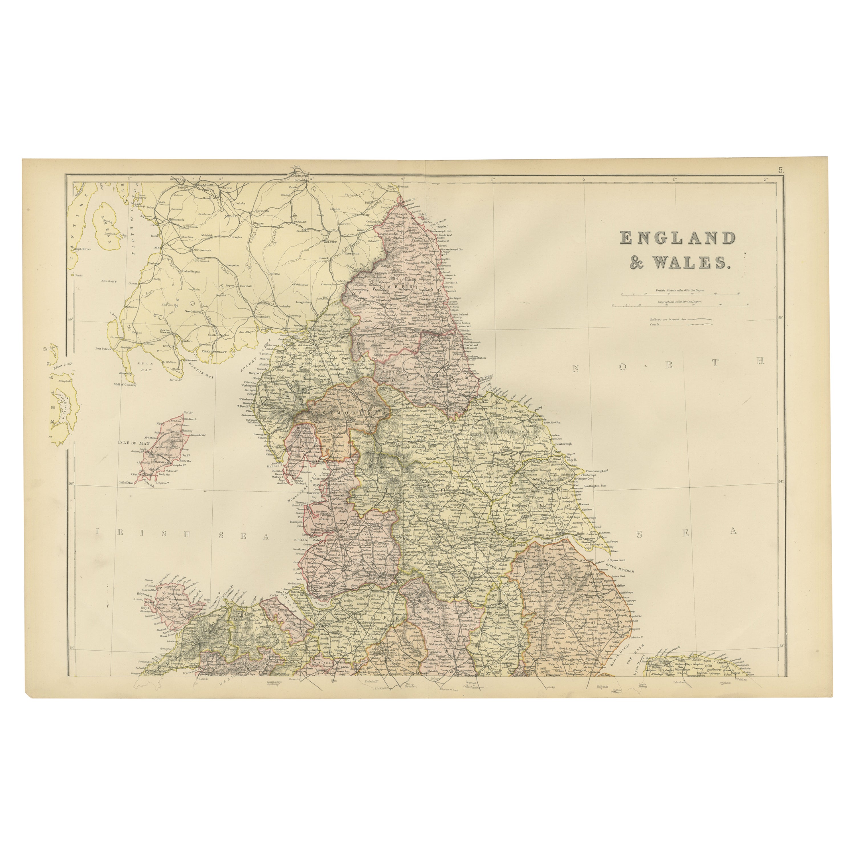
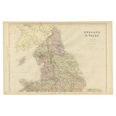
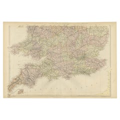
- Colorful Detailed Antique Map of England and Wales, 1882Located in Langweer, NLExplore the Historic Splendor of 'England and Wales' with this Antique Map! Part of a distinguished collection, this map presents a captivating view of the enchanting landscapes, cit...Category
Antique 1880s Maps
MaterialsPaper
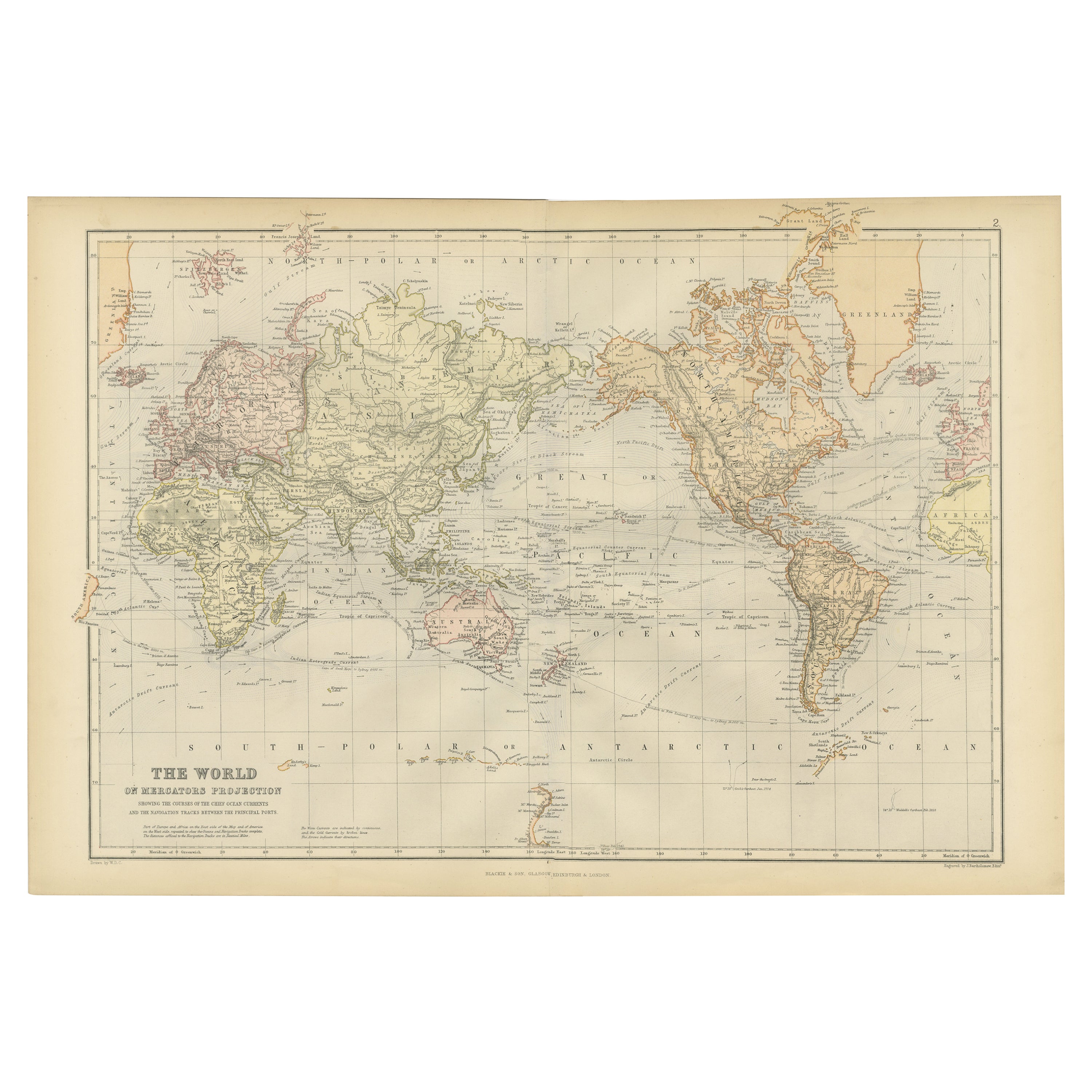
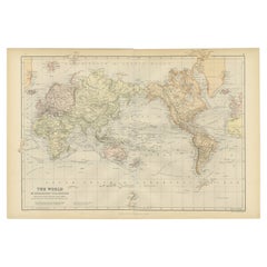
- Colorful Detailed Antique Map of The World on Mercators Projection, 1882Located in Langweer, NLThe 'World of Mercator's Projection' is a map with a stunning portrayal of global geography and maritime navigation from an era steeped in exploration and discovery. With meticulous detail and precision, this map showcases the world's continents on Mercator's famous projection, capturing the essence of a bygone era's cartographic expertise. Illustrating the courses of chief ocean currents and key navigation tracks between major ports, this map doesn't just depict landmasses but also reveals the vital maritime routes that shaped global trade and exploration. Each line and curve represents the pathways of ancient voyages and modern seafaring, connecting distant shores and continents. Crafted with the precision characteristic of Mercator's projection, this map offers a unique perspective on how sailors and explorers navigated the world's vast oceans. It stands as a testament to the artistry and scientific ingenuity of cartographers of that time, showcasing their commitment to accurate representation amid the challenges of mapping a spherical world on a flat surface. This map isn't just a historical document; it's a captivating piece of cartographic art...Category
Antique 1880s Maps
MaterialsPaper
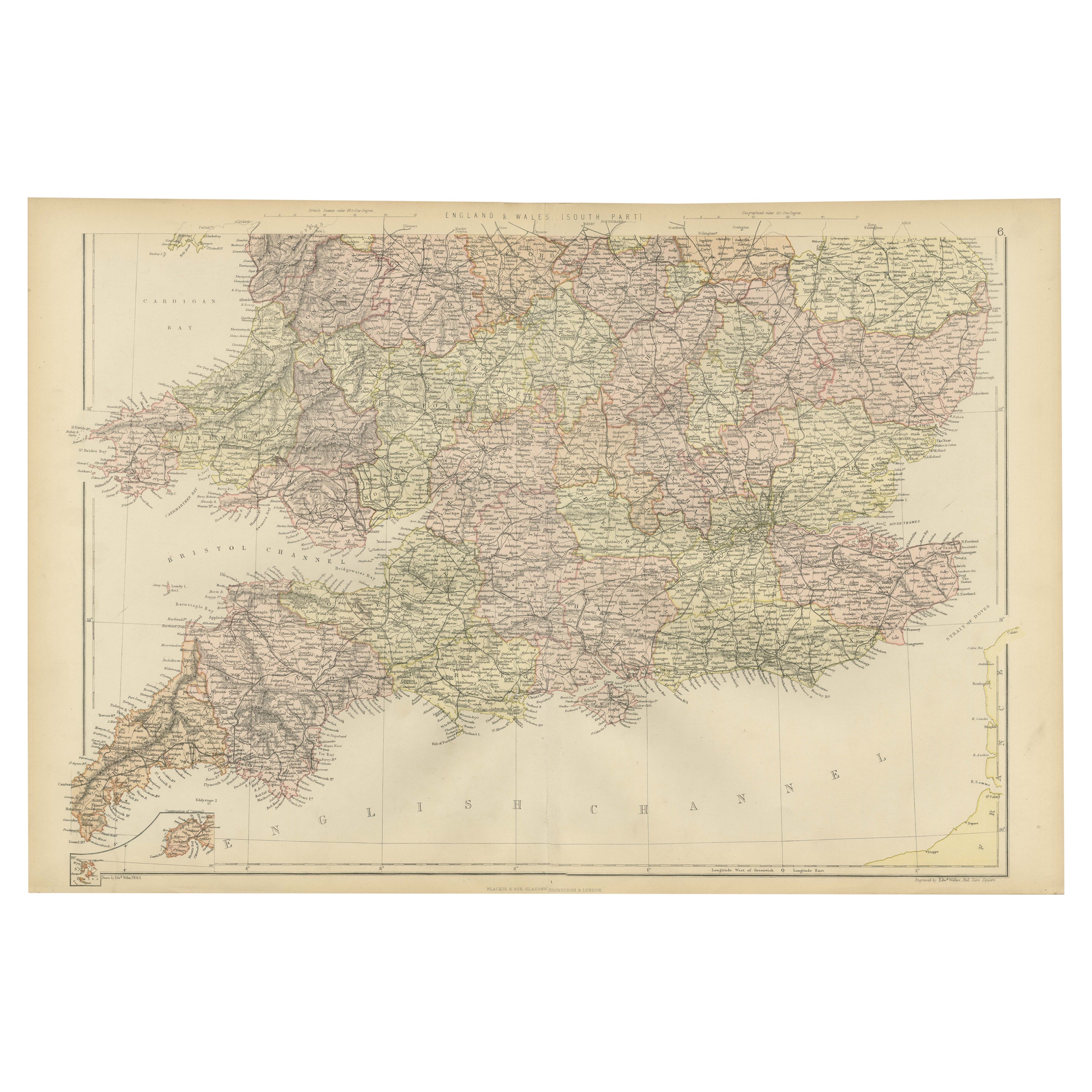
- Colorful Detailed Antique Map of England and Wales (South Part), 1882Located in Langweer, NLEmbark on a Journey Through the Southern Part of 'England and Wales' with this Exquisite Antique Map! This map provides a vivid portrayal of the captivating landscapes and cultural h...Category
Antique 1880s Maps
MaterialsPaper
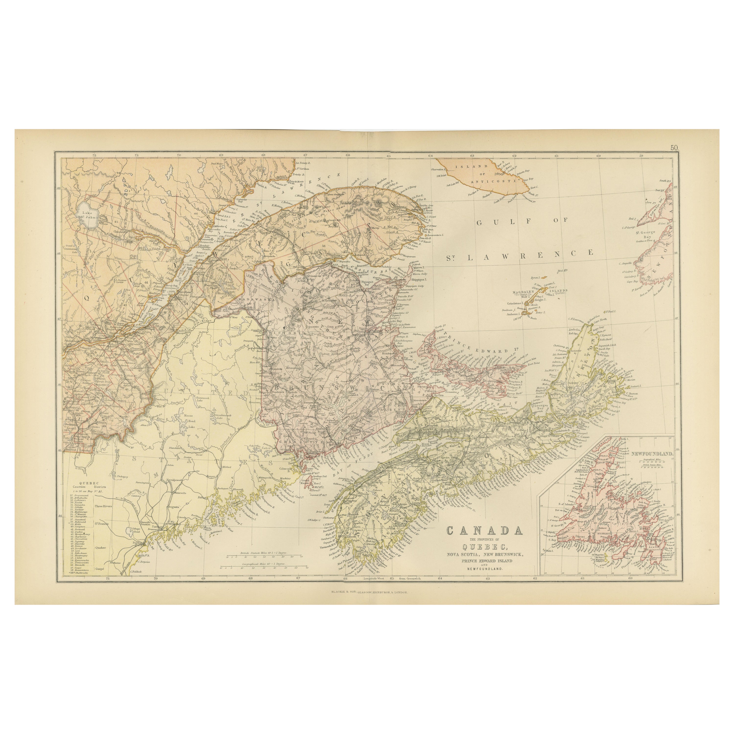
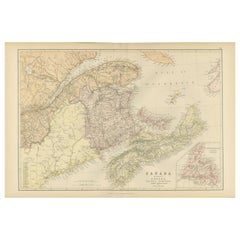
- Decorative Antique Map of Eastern Canada, Published in 1882Located in Langweer, NLThis is a historical map from the 1882 Blackie Atlas, focused on eastern Canada and the maritime provinces. The map is titled "Canada. No. 2. Provinces of Nova Scotia, New Brunswick,...Category
Antique 1880s Maps
MaterialsPaper
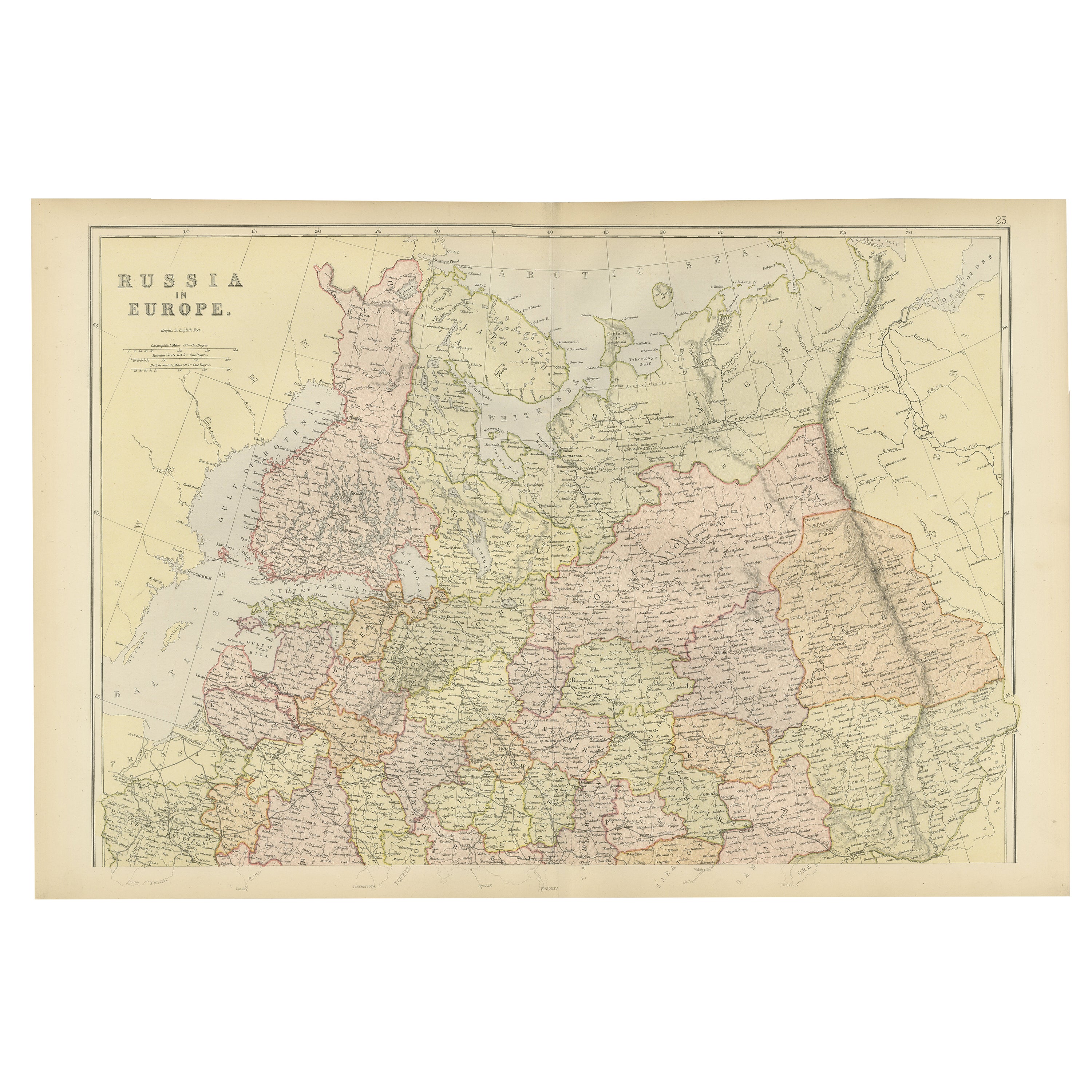
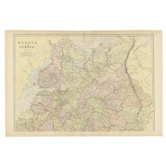
- Original Antique Map of Russia in Europe, 1882Located in Langweer, NLEmbark on an enthralling journey with an original Antique Map of European Russia from the esteemed 'Comprehensive Atlas and Geography of the World,' meticulously crafted in 1882. Thi...Category
Antique 1880s Maps
MaterialsPaper
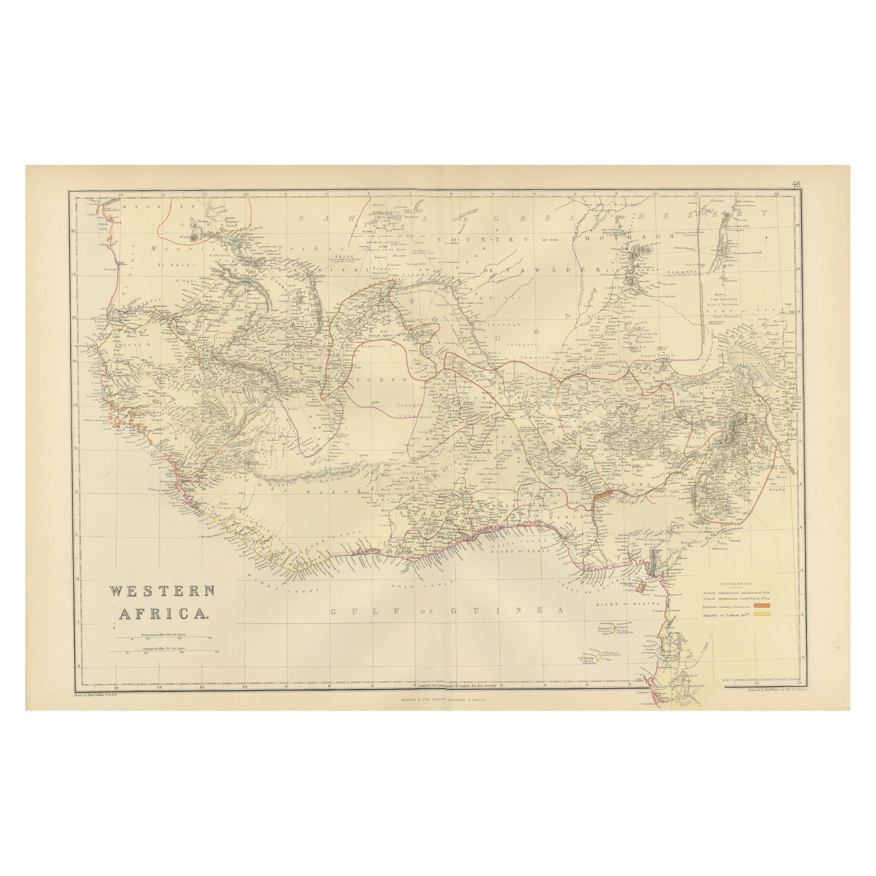
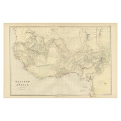
- Original Antique Coloured Map of Western Africa, Published in 1882Located in Langweer, NLThis is a map of Western Africa from the 1882 Blackie & Son atlas. The map details the West African coast from the Sahara Desert in the north down to the Gulf of Guinea, including a ...Category
Antique 1880s Maps
MaterialsPaper
You May Also Like
- Original Antique Map of Europe, Arrowsmith, 1820Located in St Annes, LancashireGreat map of Europe Drawn under the direction of Arrowsmith. Copper-plate engraving. Published by Longman, Hurst, Rees, Orme and Brown, 1820 ...Category
Antique 1820s English Maps
MaterialsPaper
- Antique Hand Colored Framed Map of EuropeLocated in West Palm Beach, FLAntique reproduction copied from an edition dated 1595 by Ortelius.Category
Antique Late 19th Century Maps
- Antique Oarsman's Map of the River Thames, English, Cartography, Published 1912Located in Hele, Devon, GBThis is an antique copy of The Oarsman's and Angler's Map of the River Thames - New Edition. An English, bound map book, published in English by Edward Stanford, London, this new edi...Category
Early 20th Century British Other Books
MaterialsPaper
- London 1744 Published Watercolour Antique Map of East Africa by Eman BowenLocated in GBWe are delighted to offer for sale this New and Accurate Map of Nubia & Abissinia, together with all the Kingdoms Tributary Thereto, and bordering upon them published in 1744 by Emanuel Bowen This is a decorative antique engraved map of East Africa...Category
Antique 1740s English George III Maps
MaterialsPaper
- Antique Paterson's Guide to Britain, English, Maps, Georgian, Published 1811Located in Hele, Devon, GBThis is an antique copy of Paterson's New and Accurate guide to Direct & Principal Crossroads. An English, bound book of maps and descriptive tables, published in English by Longman,...Category
Antique Early 19th Century British Georgian Books
MaterialsPaper
- Large Original Antique Map of Europe by Sidney Hall, 1847Located in St Annes, LancashireGreat map of Europe Drawn and engraved by Sidney Hall Steel engraving Original colour outline Published by A & C Black. 1847 Unframed Free shipping.Category
Antique 1840s Scottish Maps
MaterialsPaper


Recently Viewed
View AllMore Ways To Browse
Rare Map Of Ireland
Antique European Map Prints
Carl Probst
Mid Century Maps
Levasseur A
Important Map
Asian Bassett
Clivia Ducatus Et Ravestein Dominium
18th Century European Maps
Vintage Nantucket Map
Vintage Nantucket Maps
Rand Mcnally Map Of California
Uruguay Antique Map
Derbyshire Antique Map
Antique Furniture Perth Australia
Tanzania Antique Map
Aigue Marine
Cincinnati Map