Items Similar to Antique Engraving – Layout of the King of Persia’s Field Camp, 18th Century

Want more images or videos?
Request additional images or videos from the seller
1 of 10
Antique Engraving – Layout of the King of Persia’s Field Camp, 18th Century
$226.43
£167.69
€190
CA$311.96
A$346.84
CHF 182.63
MX$4,208.21
NOK 2,312.21
SEK 2,161.36
DKK 1,446.25
About the Item
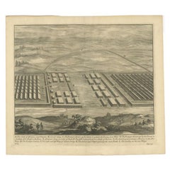
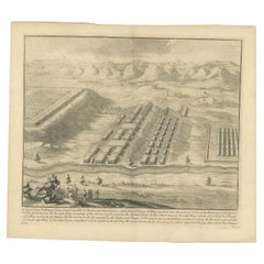
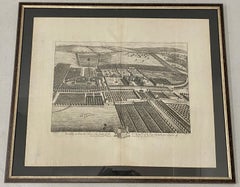
Antique Engraving – Layout of the King of Persia’s Field Camp, 18th Century
Fascinating 18th-century engraved plan depicting the arrangement of the royal encampment of the King of Persia. The detailed layout shows the precise placement of the king’s central pavilion, the tents of his guards, the princes’ quarters, the chancery, and other military and ceremonial structures. Surrounding the royal enclosure are orderly rows of tents for troops, officials, and service areas, with careful attention to scale and proportions. This image reflects the grandeur and organisation of a Persian royal field army, where the entire encampment could extend over four to five leagues, as noted in the French text. The engraving offers a unique combination of military precision and courtly splendour, making it both a historical document and a work of art. Produced during the Enlightenment era, it would have been intended for readers eager to learn about foreign customs, military science, and the magnificence of Eastern courts. This rare print is not only an invaluable resource for historians of Persian history and military architecture but also a striking decorative piece for collectors of antique prints.
Condition: Good impression with crisp lines and rich detail. Minor toning and light handling marks in the margins, consistent with age. Fold lines as issued. One tear repaired with archival tape on the reverse.
Framing tips: A simple black or dark mahogany frame with a cream or lightly toned archival mount will emphasise the engraving’s fine linework and period character, while allowing the detailed arrangements to be easily studied.
Technique: Engraving
Maker: Unidentified, France, 18th century
- Dimensions:Height: 13.98 in (35.5 cm)Width: 10.12 in (25.7 cm)Depth: 0.01 in (0.2 mm)
- Materials and Techniques:Paper,Engraved
- Place of Origin:
- Period:
- Date of Manufacture:circa 1760
- Condition:Repaired: One tear repaired with archival tape on the reverse. Condition: Good impression with crisp lines and rich detail. Minor toning and light handling marks in the margins, consistent with age. Fold lines as issued. One tear repaired with archival tape on the reverse.
- Seller Location:Langweer, NL
- Reference Number:Seller: BG-14078-381stDibs: LU3054346219572
About the Seller
5.0
Recognized Seller
These prestigious sellers are industry leaders and represent the highest echelon for item quality and design.
Platinum Seller
Premium sellers with a 4.7+ rating and 24-hour response times
Established in 2009
1stDibs seller since 2017
2,569 sales on 1stDibs
Typical response time: <1 hour
- ShippingRetrieving quote...Shipping from: Langweer, Netherlands
- Return Policy
Authenticity Guarantee
In the unlikely event there’s an issue with an item’s authenticity, contact us within 1 year for a full refund. DetailsMoney-Back Guarantee
If your item is not as described, is damaged in transit, or does not arrive, contact us within 7 days for a full refund. Details24-Hour Cancellation
You have a 24-hour grace period in which to reconsider your purchase, with no questions asked.Vetted Professional Sellers
Our world-class sellers must adhere to strict standards for service and quality, maintaining the integrity of our listings.Price-Match Guarantee
If you find that a seller listed the same item for a lower price elsewhere, we’ll match it.Trusted Global Delivery
Our best-in-class carrier network provides specialized shipping options worldwide, including custom delivery.More From This Seller
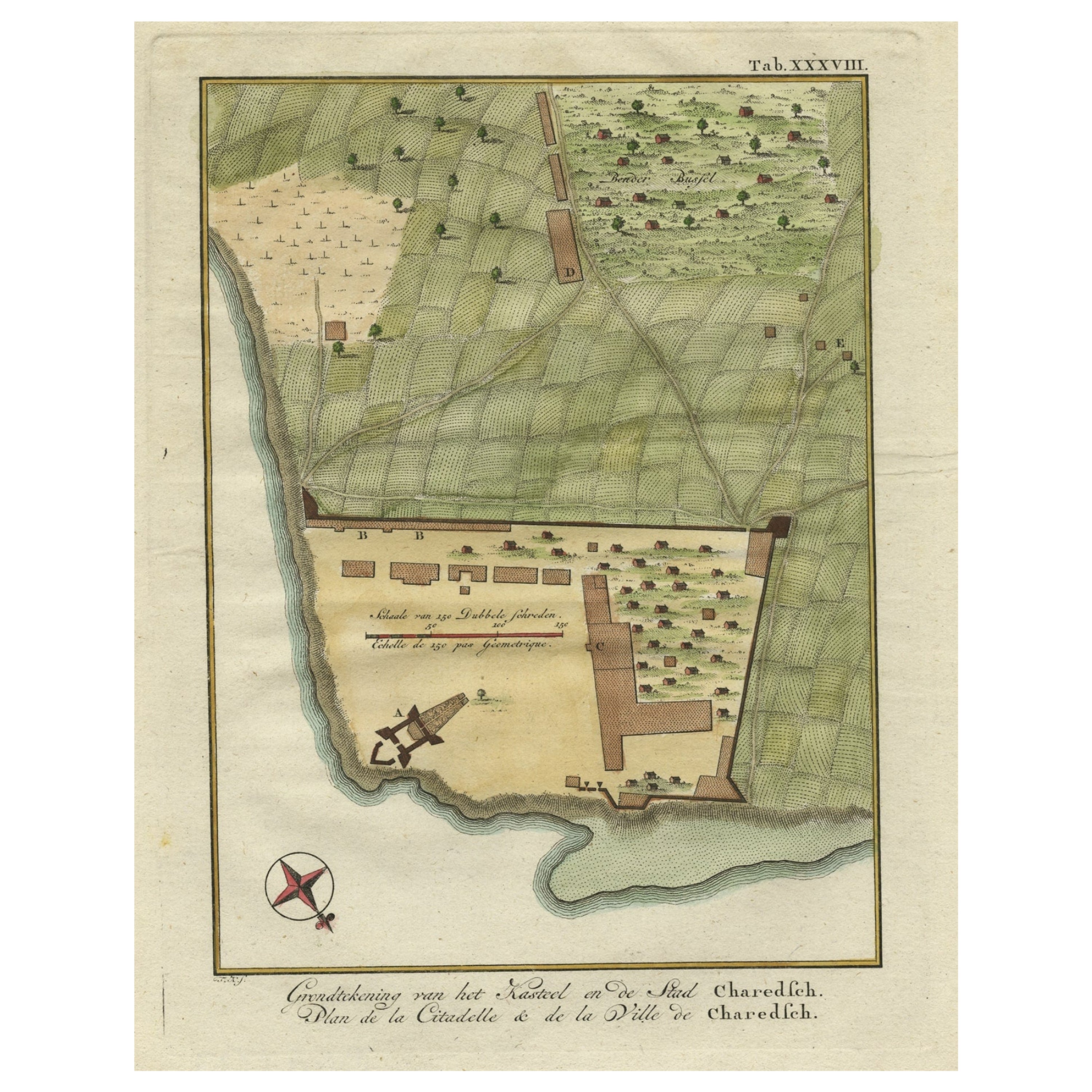
View AllOriginal Antique Plan of the Fortress of Charedsch in Persia or Iran, ca.1780
Located in Langweer, NL
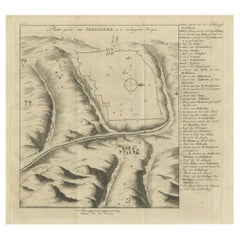
Antique map, titled: 'Plan de la Citadelle de la Ville de Charedsch.'
Plan of the fortress of Charedsch, Iran / Persia. This original antique print originates from 'Reize naar Ar...
Category
Antique 1780s Maps
Materials
Paper

$305 Sale Price
20% Off
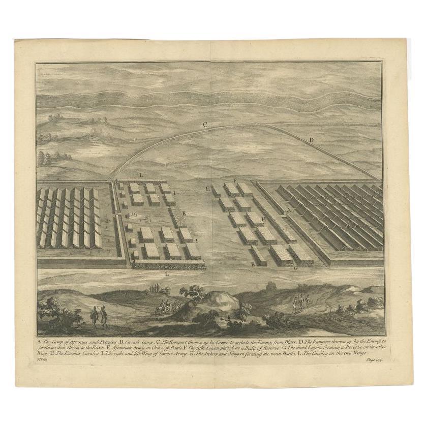
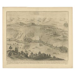
Antique Print of the Camp of Afranius and Petreius, C.1753
Located in Langweer, NL
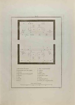
Antique battle map of the Camp of Afranius and Petreius. With detailed legend explaining the various elements of the print. This print most likely originates from an edition of 'The Commentaries of Caesar, Translated into English. To Which is Prefixed a Discourse Concerning The Roman Art of War...
Category
Antique 18th Century Prints
Materials
Paper
$276 Sale Price
20% Off
Antique Print of the Camp of Labienus and Camulogenus, C.1753
Located in Langweer, NL
Antique battle map showing the camp of Labienus and Camulogenus. With detailed legend explaining the various elements of the print. This print most likely originates from an edition ...
Category
Antique 18th Century Prints
Materials
Paper
$324 Sale Price
20% Off
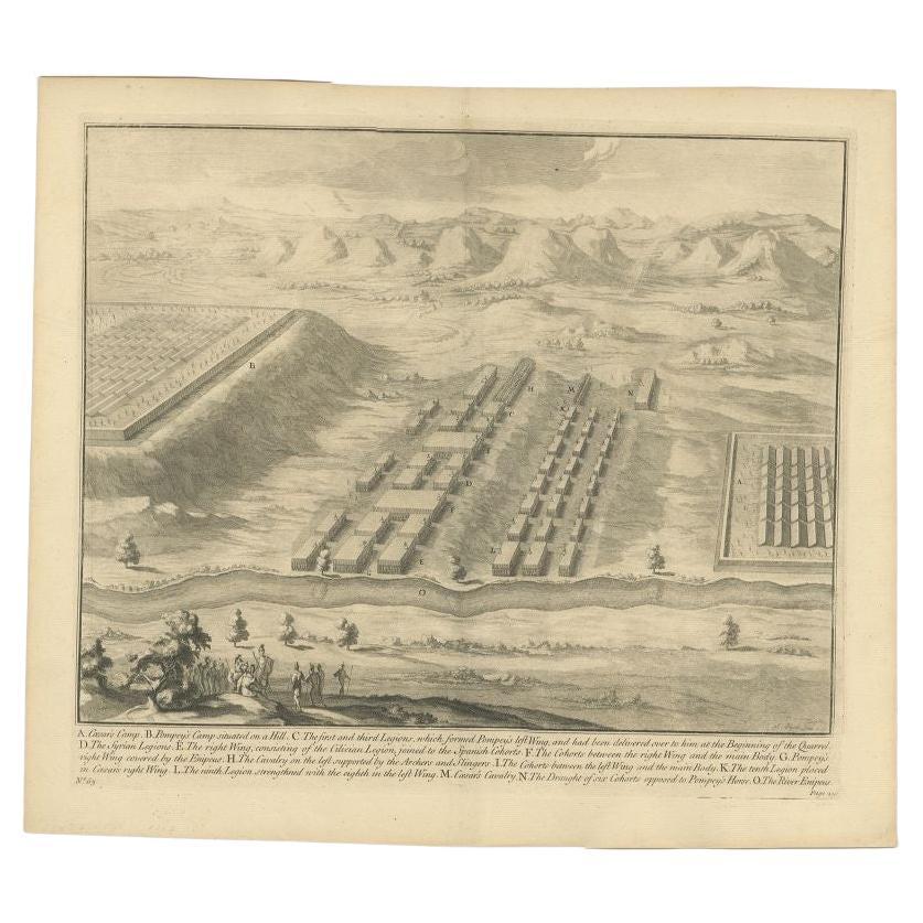
Antique Print of Caesar's Camp, C.1753
Located in Langweer, NL
Antique battle map of Caesar's Camp. With detailed legend explaining the various elements of the print. This print most likely originates from an e...
Category
Antique 18th Century Prints
Materials
Paper
$276 Sale Price
20% Off
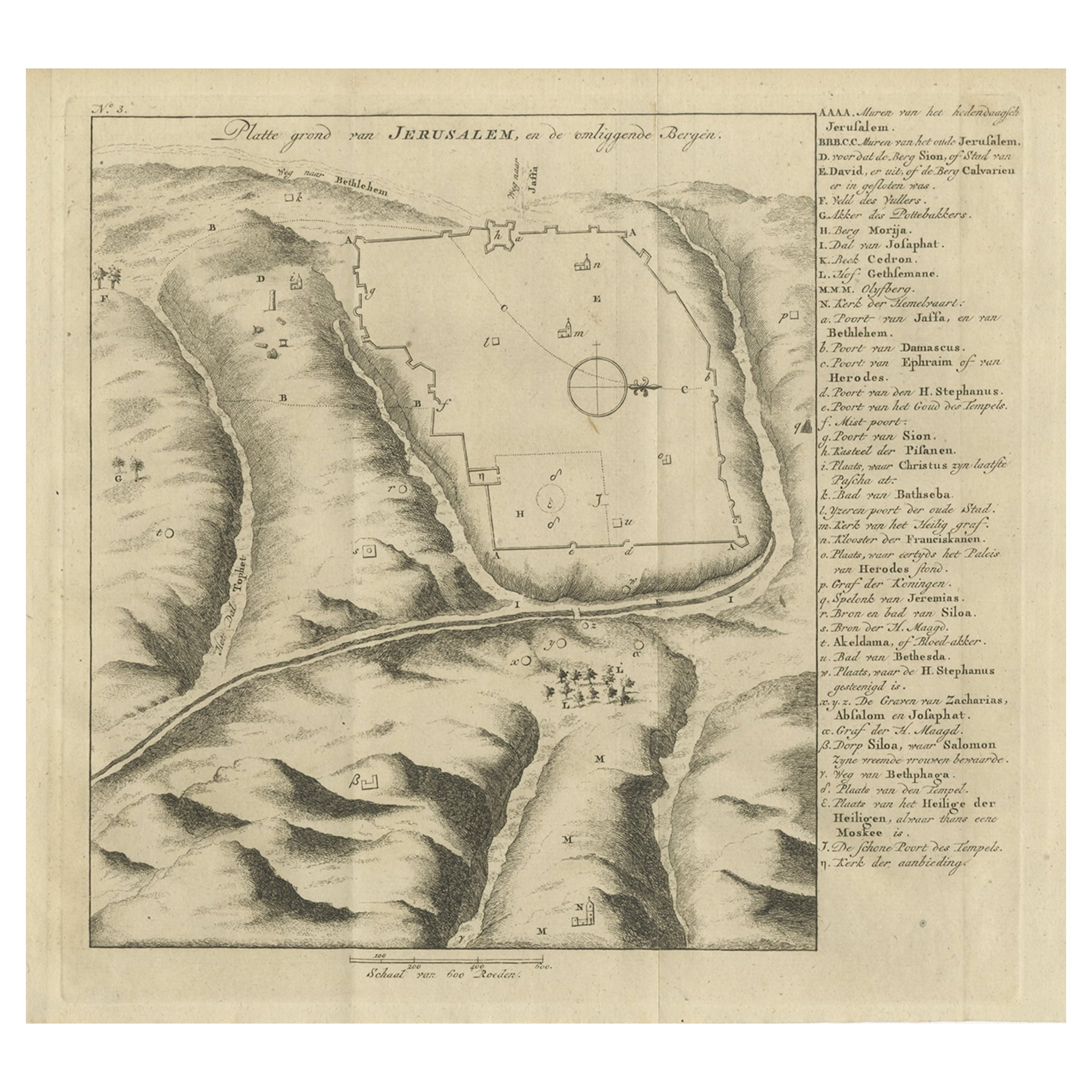
Antique Engraving of a Map or Plan of Jerusalem and Surrounding Mountains, 1773
Located in Langweer, NL
Antique map titled 'Platte grond van Jerusalem, en de omliggende Bergen'. Plan of the city of Jerusalem, with surrounding mountains. Originates from the first Dutch editon of an inte...
Category
Antique 18th Century Maps
Materials
Paper
$257 Sale Price
20% Off
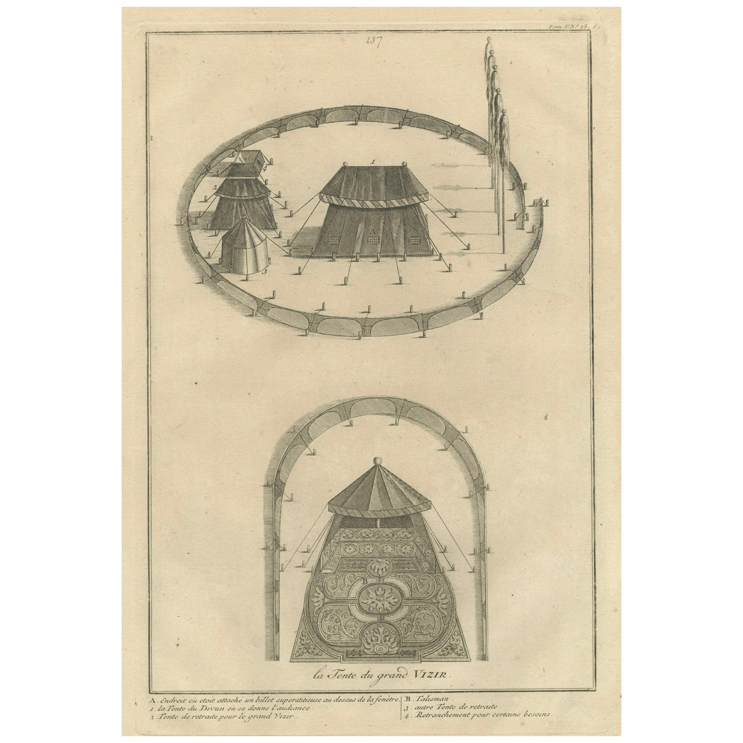
Ottoman Military Encampment – The Grand Vizier’s Tent, 1734 Engraving
Located in Langweer, NL
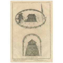
Title: Ottoman Military Encampment – The Grand Vizier’s Tent, 1734 Engraving
Description: This rare 1734 copperplate engraving presents a detailed architectural depiction of *La Ten...
Category
Antique 1730s Prints
Materials
Paper
You May Also Like
17th-18th Century Siege of Graves Mapping Engraving By Willian III
Located in Kingston, NY
RARE French 17th-18th Century Enhanced Siege of Graves Mapping Engraving BY William III, also widely known as William of Orange,
The Siege of Grave in Dutch Brabant started by Monsie...
Category
Antique 17th Century French Prints
Materials
Paper

Architectural Roman Map - Etching by Vincenzo Scarpati - 18th Century
Located in Roma, IT
Architectural Roman Map from "Antiquities of Herculaneum" is an etching on paper realized by Vincenzo Scarpati in the 18th Century.
Signed on the plate.
Go...
Category
18th Century Old Masters Figurative Prints
Materials
Etching

Map - Etching by Nicola Fiorillo - 18th Century
Located in Roma, IT
Map from "Antiquities of Herculaneum" is an etching on paper realized by Nicola Fiorillo in the 18th Century.
Signed on the plate.
Good conditions with some folding and foxing.
Th...
Category
18th Century Old Masters Figurative Prints
Materials
Etching
18th C. Engraving "Shire of the Seat of Phillip Stanhope, Earl of Chesterfield"
Located in San Francisco, CA
18th C. Engraving "Shire of the Seat of Phillip Stanhope, Earl of Chesterfield" C.1724
Bird's eye view of Bredby Hall, in Derbyshire; with formal gardens and landscaped grounds; fro...
Category
Early 18th Century Landscape Prints
Materials
Etching
Plan of the Park, Garden and Plantations of Goodwood, 18th century engraving
By Colen Campbell
Located in Melbourne, Victoria
Plan of the Park, Garden and Plantations of Goodwood in Sussex the Seat of his Grace the Duke of Richmond and Lenox &c
Copper-line engraving with later hand-colouring by Hendrik Hul...
Category
18th Century English School Landscape Prints
Materials
Engraving
The Encampment of Ibrahim Pasha - Original Lithograph Mid-19th Century
Located in Roma, IT
The Encampment of Ibrahim Pasha is an original modern artwork realized in the mid-19th Century.
Original B/W Lithograph on Ivory Paper.
Inscripted on the lower margin in Capital ...
Category
Mid-19th Century Figurative Prints
Materials
Paper, Lithograph