Items Similar to Antique Map of the Amazon River – Maragnon or River of the Amazons, c.1760


Want more images or videos?
Request additional images or videos from the seller
1 of 10
Antique Map of the Amazon River – Maragnon or River of the Amazons, c.1760
$549.13
£404.56
€460
CA$755.78
A$838.65
CHF 442.37
MX$10,238.17
NOK 5,596.84
SEK 5,241.89
DKK 3,501.55
About the Item
Map of the Amazon River – “Cours du Fleuve Maragnon autrement dit des Amazones”, c.1760
This 18th-century copperplate map, titled Cours du Fleuve Maragnon autrement dit des Amazones, depicts the course of the Amazon River from its sources in the Andes to its wide delta on the Atlantic coast. Based on the work of Father Samuel Fritz, a Jesuit missionary and cartographer who spent decades in the Amazon basin, the map provides a detailed representation of the river’s extensive tributary network and surrounding geography.
The map shows the river originating in the highlands near Quito and flowing eastward through dense rainforest before reaching the Atlantic Ocean near the Cap de Nord. Key tributaries, towns, and indigenous territories are marked along the route, with mountain ranges and other geographical features indicated pictorially. Settlements such as Quito, Lima, Truxillo, and Cuzco are labeled, reflecting the colonial centers of Spanish South America at the time.
A large compass rose decorates the lower left corner, and the Equator (*Ligne Équinoxiale*) is marked, emphasizing the river’s position in the tropics. The work’s cartographic precision reflects Fritz’s extensive travels and surveys, which corrected many earlier misconceptions about the river’s course and size.
Engraved by Porlier (Porlier Sculp.), the plate is marked “Tome 25, N° 22” in the upper corners, indicating its inclusion in a large multi-volume series documenting geography and exploration. The map is both a valuable historical document of Jesuit missionary cartography and an important visual record of the Amazon in the 18th century.
Condition: Very good for age, with folds as issued. Minor toning and faint spotting in margins. Strong plate impression with fine engraved detail.
Framing tips: A dark or walnut-stained frame with an ivory mount will complement the aged paper and precise linework. This map pairs well with other 18th-century South American or river charts for thematic display.
Technique: Copperplate engraving
Maker: Father Samuel Fritz (source), engraved by A. Porlier, French school, c.1760
- Dimensions:Height: 9.85 in (25 cm)Width: 15.56 in (39.5 cm)Depth: 0.01 in (0.2 mm)
- Materials and Techniques:Paper,Engraved
- Place of Origin:
- Period:
- Date of Manufacture:circa 1760
- Condition:Condition: Very good for age, with folds as issued. Minor toning and faint spotting in margins. Strong plate impression with fine engraved detail.
- Seller Location:Langweer, NL
- Reference Number:Seller: BG-14078-371stDibs: LU3054346219472
About the Seller
5.0
Recognized Seller
These prestigious sellers are industry leaders and represent the highest echelon for item quality and design.
Platinum Seller
Premium sellers with a 4.7+ rating and 24-hour response times
Established in 2009
1stDibs seller since 2017
2,569 sales on 1stDibs
Typical response time: <1 hour
- ShippingRetrieving quote...Shipping from: Langweer, Netherlands
- Return Policy
Authenticity Guarantee
In the unlikely event there’s an issue with an item’s authenticity, contact us within 1 year for a full refund. DetailsMoney-Back Guarantee
If your item is not as described, is damaged in transit, or does not arrive, contact us within 7 days for a full refund. Details24-Hour Cancellation
You have a 24-hour grace period in which to reconsider your purchase, with no questions asked.Vetted Professional Sellers
Our world-class sellers must adhere to strict standards for service and quality, maintaining the integrity of our listings.Price-Match Guarantee
If you find that a seller listed the same item for a lower price elsewhere, we’ll match it.Trusted Global Delivery
Our best-in-class carrier network provides specialized shipping options worldwide, including custom delivery.More From This Seller
View AllAntique Map of Northern Brazil by Bonne, c.1780
Located in Langweer, NL
Antique map titled 'Carte de la Partie Septentrionale du Bresil.' Detailed map of the northern portion of Brazil from Bahia to French Guiana, showing the eastern Amazon interior rivers, Mission Territories, Goyza and the coastal regions, including coastal currents. Source unknown, to be determined. Artists and Engravers: Rigobert Bonne (1727-1795 ) was one of the most important cartographers of the late 18th century. In 1773 he succeeded Jacques Bellin as Royal Cartographer to France in the office of the Hydrographer at the Depôt de la Marine. Working in his official capacity Bonne compiled some of the most detailed and accurate maps of the period. Bonne's work represents an important step in the evolution of the cartographic ideology away from the decorative work of the 17th and early 18th century towards a more detail oriented and practical aesthetic. With regard to the rendering of terrain Bonne maps...
Category
Antique 18th Century Maps
Materials
Paper

$119 Sale Price
20% Off
Antique Map of South America by G. Anson, 1749
Located in Langweer, NL
Antique map titled 'Kaart van het Zuidelykste Gedeelte van Zuider Amerika (..) - Carte de la Partie Meridionale de l'Amerique Meridionale (..)'. Detailed chart tracking the route of Capt. George Anson's ship The Centurion in 1745. The chart shows the tracks of Anson's ships around South America & Cape Horn to the Juan Fernandes Islands, with notes on currents and positions. This map originates from 'Reize rondsom de Werreld (..)' by George Anson, published 1749.
In 1740 Capt. George Anson (1697-1762) of the Royal Navy, was given command of a squadron of ships. As England was at war with France and Spain, Anson's task was to intercept and capture a Spanish treasure...
Category
Antique Mid-18th Century Dutch Maps
Materials
Paper

Antique Map of the Bahia Todos Santos 'Brazil' by Tirion, circa 1750
Located in Langweer, NL
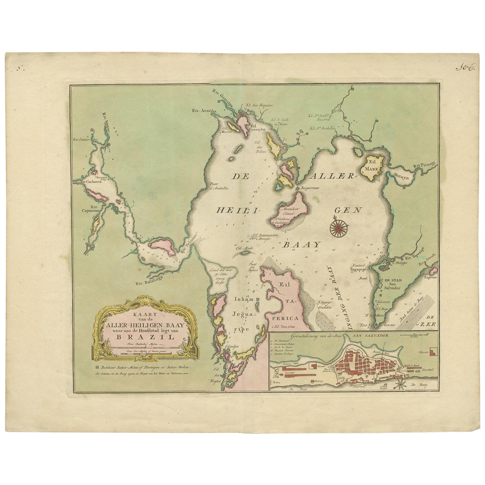
Antique map titled 'Kaart Van De Aller-Heiligen Baay Waar aan de Hoofdstad legt van Brazil.', Detailed map of the Bahia Todos Santos in Brazil, with a lar...
Category
Antique Mid-18th Century Maps
Materials
Paper

$429 Sale Price
20% Off
Antique Map of South America Depicting Guayana, c.1780
Located in Langweer, NL
Antique map titled 'La Guyane Francopise avec partie de la Guyane Hollandoise: suivant les Operations et les Cartes recentes des Ingenieurs-Geographes Francois'. Antique map of South...
Category
Antique 18th Century Maps
Materials
Paper

$334 Sale Price
20% Off
Antique Map of South America by J. Cook (1775)
Located in Langweer, NL
Antique map titled 'Kaart van het Zuidlyk Eind van Amerika'. Map of the sourthern part of South America, focusing on Cook's tracks around the Cape Horn and Tierra del Fuego in 1775. ...
Category
Antique Late 18th Century Maps
Materials
Paper

$563 Sale Price
20% Off
Antique Map of South America by J. Cook, 1775
Located in Langweer, NL
Antique map titled 'Kaart van het Zuidlyk Eind van Amerika'. Map of the sourthern part of South America, focusing on Cook's tracks around the Cape Horn and T...
Category
Antique Mid-18th Century Maps
Materials
Paper

$810 Sale Price
20% Off
You May Also Like
Original Antique Map of Central America / Florida, Arrowsmith, 1820
Located in St Annes, Lancashire
Great map of Central America.
Drawn under the direction of Arrowsmith.
Copper-plate engraving.
Published by Longman, Hurst, Rees, Orme and Brown, 1820
Unframed.
Category
Antique 1820s English Maps
Materials
Paper

Southerlandia Map - Etching by Johannes Janssonius - 1650
By Johannes Janssonius
Located in Roma, IT
Southerlandia Map is an ancient map realized in 1650 by Johannes Janssonius (1588-1664).
The Map is Hand-colored etching, with coeval watercoloring.
Good conditions.
From Atlantis...
Category
1650s Modern Figurative Prints
Materials
Etching

Map of South America - Original Etching - Late 19th Century
Located in Roma, IT
This Map of South America is an etching realized by an anonymous artist.
The state of preservation of the artwork is good with some small diffused stains.
Sheet dimension: 41.5 x 27
The artwork represents the map South America...
Category
Late 19th Century Modern Figurative Prints
Materials
Etching
Antique 1765 Wine Country Folding Map of France, Bordeau etc.
Located in Paonia, CO
Route du Carosse de Bordeaux, part de Paris tous les Mardis a 11 matin. a et pafse 1765 is a comprehensive map with two routes through the wine country of France starting in Paris going south...
Category
1760s Other Art Style Landscape Prints
Materials
Etching

Original Antique Map of South America. C.1780
Located in St Annes, Lancashire
Great map of South America
Copper-plate engraving
Published C.1780
Two small worm holes to left side of map
Unframed.
Category
Antique Early 1800s English Georgian Maps
Materials
Paper

Original Antique Map of Switzerland, Engraved By Barlow, Dated 1807
Located in St Annes, Lancashire
Great map of Switzerland
Copper-plate engraving by Barlow
Published by Brightly & Kinnersly, Bungay, Suffolk.
Dated 1807
Unframed.
Category
Antique Early 1800s English Maps
Materials
Paper
