Items Similar to Antique Map of the Bahia Todos Santos 'Brazil' by Tirion, circa 1750


Want more images or videos?
Request additional images or videos from the seller
1 of 5
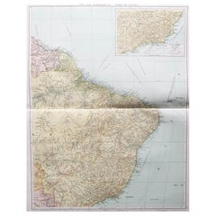
Antique Map of the Bahia Todos Santos 'Brazil' by Tirion, circa 1750
About the Item
Antique map titled 'Kaart Van De Aller-Heiligen Baay Waar aan de Hoofdstad legt van Brazil.', Detailed map of the Bahia Todos Santos in Brazil, with a large inset plan of San Salvador.
- Dimensions:Height: 16.54 in (42 cm)Width: 20.48 in (52 cm)Depth: 0.02 in (0.5 mm)
- Materials and Techniques:
- Period:
- Date of Manufacture:circa 1750
- Condition:Great original (contemporary) hand coloring, small tear on folding line. Please study image carefully.
- Seller Location:Langweer, NL
- Reference Number:
About the Seller
5.0
Platinum Seller
These expertly vetted sellers are 1stDibs' most experienced sellers and are rated highest by our customers.
Established in 2009
1stDibs seller since 2017
1,947 sales on 1stDibs
Typical response time: <1 hour
- ShippingRetrieving quote...Ships From: Langweer, Netherlands
- Return PolicyA return for this item may be initiated within 14 days of delivery.
More From This SellerView All
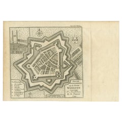
- Antique Map of the City of Woerden by Tirion, c.1750Located in Langweer, NLAntique map titled 'Nieuwe Grondtekening van de Stad Woerden'. Plan of the city of Woerden, the Netherlands. Published circa 1750. Artists and Engravers: Published by I. Tirion. ...Category
Antique 18th Century Maps
MaterialsPaper
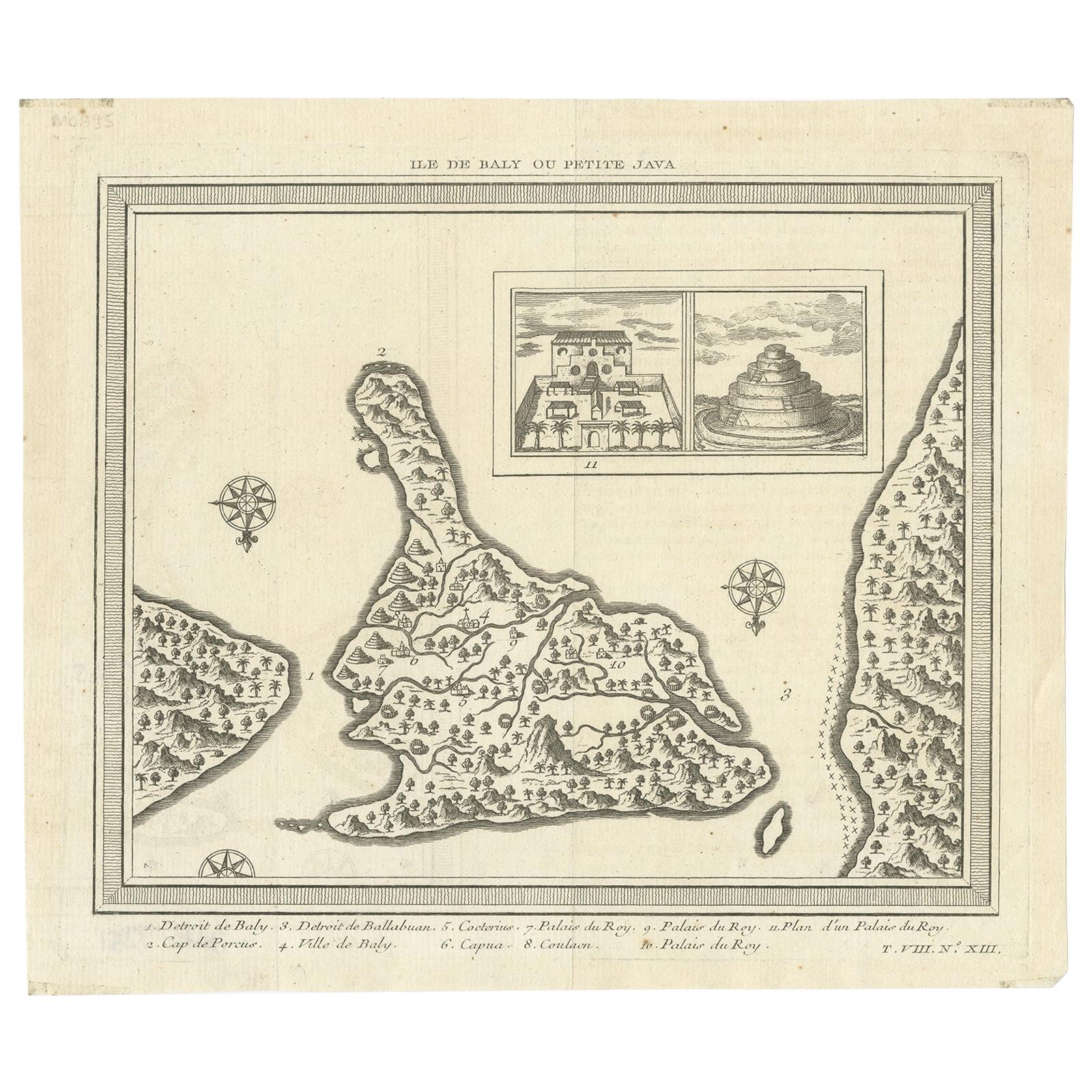
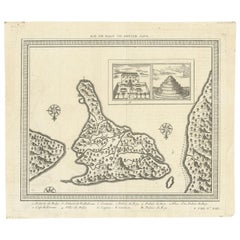
- Antique Map of Bali 'Indonesia' by Bellin, 'c.1750'Located in Langweer, NLAntique map titled 'Ile de Baly ou petite Java'. Map of Bali, Indonesia. The map depicts the island from the north with Java to the right and Lombok to the...Category
Antique Mid-18th Century Maps
MaterialsPaper
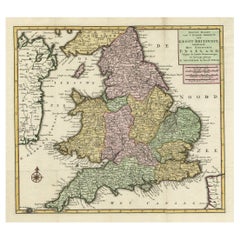
- Antique Map of the South Part of Great Britain by Tirion, c.1750By Isaak TirionLocated in Langweer, NLAntique map titled 'Nieuwe Kaart van 'T Zuider Gedeelte van Groot Britannie behelzende Het Koningryk Engeland (..).' Attractive map showing the south part of Great Britain; the K...Category
Antique 18th Century Maps
MaterialsPaper
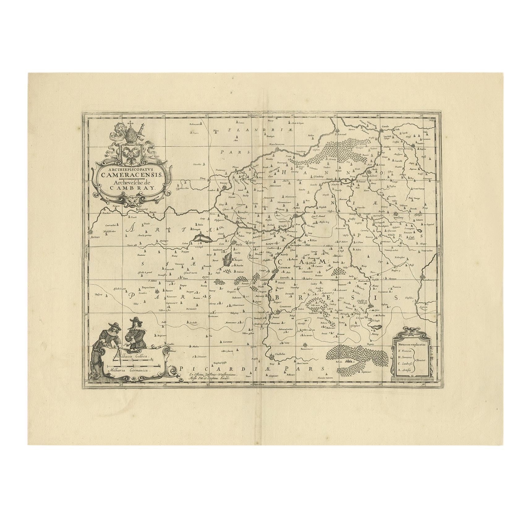
- Antique Map of the Cambrai Region by Pitt, circa 1680Located in Langweer, NLAntique map titled 'Archiepiscopatus Cameracensis - Archevesche de Cambray'. Decorative map of the Cambrai region of France. This map originates from 'The English Atlas' by Moses Pit...Category
Antique Late 17th Century Maps
MaterialsPaper
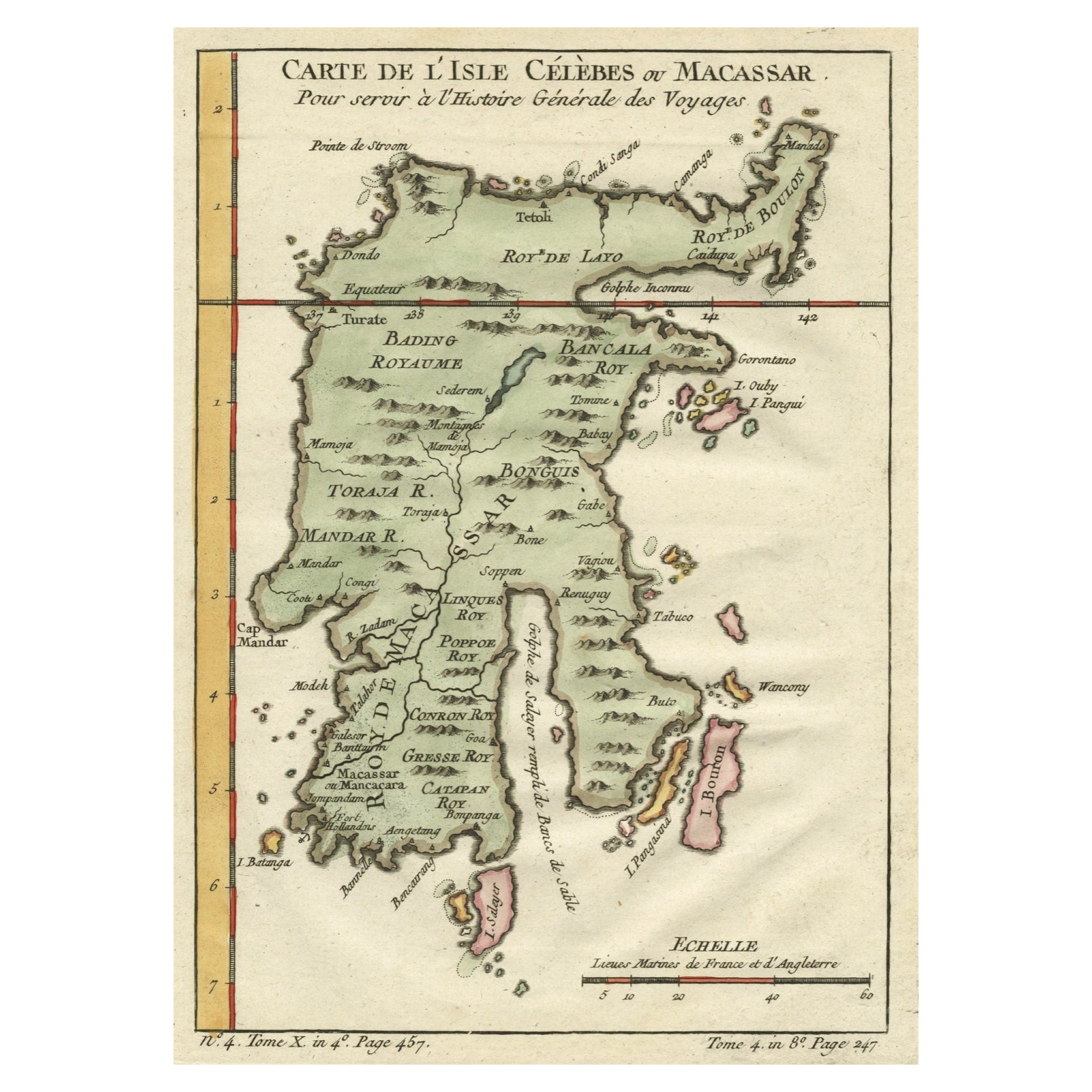
- Antique Map of Celebes 'Sulawesi', Island in Indonesia, c.1750By Jacques-Nicolas BellinLocated in Langweer, NLAntique map titled 'Carte De L'Isle Celebes ou Macassar'. Detailed copper engraved map of Celebes (Sulawesi, Indonesia), showing Makassar, which was the most important trading city o...Category
Antique 18th Century Maps
MaterialsPaper
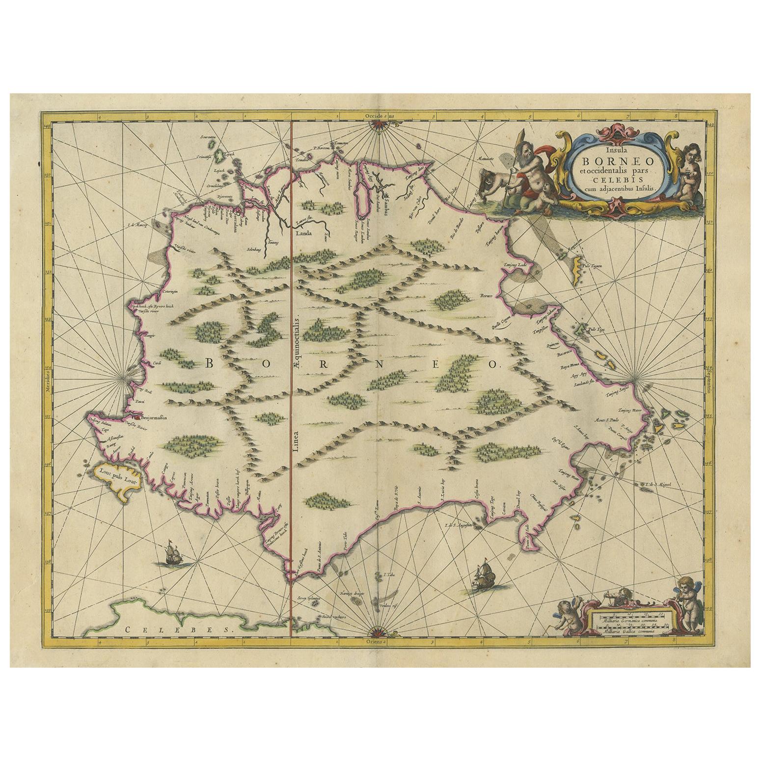
- Antique Map of the Island of Borneo by Janssonius, circa 1650Located in Langweer, NLAntique map titled 'Insula Borneo et Occidentalis pars Celebis cum adjacentibus Insulis'. Rare sea chart of the island of Borneo. Published by J. Janssonius, circa 1650.Category
Antique Mid-17th Century Maps
MaterialsPaper


You May Also Like
- Large Original Vintage Map of Brazil, circa 1920Located in St Annes, LancashireGreat map of Brazil Original color. Good condition Published by Alexander Gross Unframed.Category
Vintage 1920s English Edwardian Maps
MaterialsPaper
- Original Antique Map of The United States of America, circa 1890Located in St Annes, LancashireGreat map of the USA By The Stanford's Geographical Establishment Original colour Unframed.Category
Antique 1890s English Victorian Maps
MaterialsPaper
- Large Original Antique Map of the World, Fullarton, circa 1870Located in St Annes, LancashireGreat map of the World. From the celebrated Royal Illustrated Atlas Lithograph. Original color. Published by Fullarton, Edinburgh, circa 1870. Unframed.Category
Antique 1870s Scottish Maps
MaterialsPaper
- Large Original Antique Map of The Environs of Dublin, Ireland, circa 1880Located in St Annes, LancashireGreat map of The Environs of Dublin Published circa 1880 Unframed Free shipping.Category
Antique 1880s Scottish Maps
MaterialsPaper
- Large Original Antique Map of the Environs of Cork, Ireland, circa 1880Located in St Annes, LancashireGreat map of The Environs of Cork Published circa 1880 Unframed Free shipping.Category
Antique 1880s Scottish Maps
MaterialsPaper
- Original Antique Map of Cyprus. Circa 1880Located in St Annes, LancashireGreat map of Cyprus Drawn and Engraved by R.Walker Published W.Mackenzie, London Original colour Unframed.Category
Antique 1880s English Maps
MaterialsPaper