Items Similar to Antique Map of Asia Minor (Natolia) – Janssonius, circa 1650


Want more images or videos?
Request additional images or videos from the seller
1 of 10
Antique Map of Asia Minor (Natolia) – Janssonius, circa 1650
$704.35
$1,308.7646% Off
£527.21
£979.6146% Off
€592
€1,10046% Off
CA$967.45
CA$1,797.6246% Off
A$1,081.72
A$2,009.9646% Off
CHF 567.41
CHF 1,054.3146% Off
MX$13,102.26
MX$24,345.4246% Off
NOK 7,162.42
NOK 13,308.5546% Off
SEK 6,766.76
SEK 12,573.3646% Off
DKK 4,507.07
DKK 8,374.6246% Off
About the Item
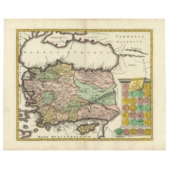
Natolia, quae olim Asia Minor – Antique Map of Anatolia by Janssonius, ca. 1650
This finely engraved 17th-century map titled “Natolia, quae olim Asia Minor” presents the region of Anatolia, now modern-day Turkey, as it was understood in antiquity. Produced by Johannes Janssonius around 1650, it is a quintessential example of Dutch Golden Age cartography, offering a detailed depiction of the ancient provinces of Asia Minor, a key region in both the classical and biblical worlds.
The map covers the area from the Aegean Sea in the west to the Euphrates River in the east, and from the Black Sea in the north to the island of Cyprus and the eastern Mediterranean. Ancient regions such as Lydia, Lycia, Pamphylia, Cilicia, Cappadocia, Phrygia, and Bithynia are all prominently labeled, and many classical cities are marked, including Ephesus, Tarsus, Antioch, and Iconium.
The decorative elements are typical of the period and include an ornate title cartouche in the upper center, with allegorical figures and putti, and a scale bar in the lower right corner. At the bottom left is a charming vignette of Mediterranean sailing vessels and sea monsters, adding visual appeal to the scholarly content.
Janssonius, a major Amsterdam-based map publisher and a contemporary of Blaeu, issued this map as part of his *Atlas Novus*. Maps from this series are known for their clarity, classical references, and balanced aesthetics, making them popular with collectors of antique maps, especially those focused on the classical world, biblical history, or Ottoman territories.
This is a superb collector’s piece for those interested in classical geography or early representations of the Ottoman Empire's western provinces. Its historical significance and decorative charm make it ideal for display.
Condition: Good impression with a strong plate mark. Centerfold as issued, light overall age toning, and minor wear to the edges. No tears or repairs. Clean and well-preserved for its age.
Framing tips: A dark walnut or aged gold frame with an ivory or parchment-colored mat enhances the classical appeal. Consider museum glass to protect the print and reduce glare.
Technique: Copper engraving
Maker: Johannes Janssonius, Amsterdam, circa 1650
- Dimensions:Height: 20.79 in (52.8 cm)Width: 25.28 in (64.2 cm)Depth: 0.02 in (0.5 mm)
- Materials and Techniques:Paper,Engraved
- Place of Origin:
- Period:Mid-17th Century
- Date of Manufacture:circa 1640
- Condition:Minor fading. Condition: Good impression with a strong plate mark. Centerfold as issued, light overall age toning, and minor wear to the edges. No tears or repairs. Clean and well-preserved for its age.
- Seller Location:Langweer, NL
- Reference Number:Seller: BG-091971stDibs: LU305439944661
About the Seller
5.0
Recognized Seller
These prestigious sellers are industry leaders and represent the highest echelon for item quality and design.
Platinum Seller
Premium sellers with a 4.7+ rating and 24-hour response times
Established in 2009
1stDibs seller since 2017
2,535 sales on 1stDibs
Typical response time: <1 hour
- ShippingRetrieving quote...Shipping from: Langweer, Netherlands
- Return Policy
Authenticity Guarantee
In the unlikely event there’s an issue with an item’s authenticity, contact us within 1 year for a full refund. DetailsMoney-Back Guarantee
If your item is not as described, is damaged in transit, or does not arrive, contact us within 7 days for a full refund. Details24-Hour Cancellation
You have a 24-hour grace period in which to reconsider your purchase, with no questions asked.Vetted Professional Sellers
Our world-class sellers must adhere to strict standards for service and quality, maintaining the integrity of our listings.Price-Match Guarantee
If you find that a seller listed the same item for a lower price elsewhere, we’ll match it.Trusted Global Delivery
Our best-in-class carrier network provides specialized shipping options worldwide, including custom delivery.More From This Seller
View AllAntique Map of Eastern Mediterranean and Asia Minor by a Benedictine, c.1725
Located in Langweer, NL
Antique map titled 'Byzondere Afbeelding der Landschappen, van de Apostelen bevaren en doorwandelt om het Evangelium J. C. te Prediken.' Map of the lands travelled by the Apostles to...
Category
Antique 18th Century Maps
Materials
Paper

$285 Sale Price
20% Off
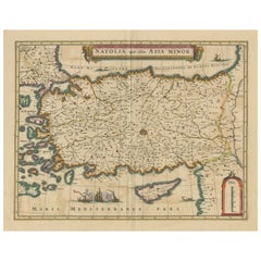
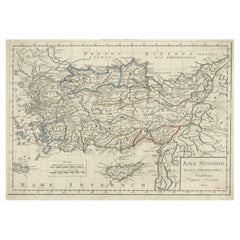
Antique Map of Asia Minor, showing Turkey, Cyprus and the Islands in the Aegean
Located in Langweer, NL
Antique map titled 'Natolia, quae olim Asia Minor'. Decorative map of Asia Minor, showing Turkey, Cyprus and the Islands in the Aegean. This attractive map shows all of Turkey, Cyprus and the Aegean Islands to a relatively high degree of accuracy. At the time the entire region was under the rule of the Ottoman Empire (Cyprus was conquered in 1571 from the Venetians). A maritime battle...
Category
Antique Mid-17th Century Maps
Materials
Paper
$628 Sale Price
20% Off
Antique Map of Asia Minor by J. Tallis, circa 1851
Located in Langweer, NL
A highly decorative mid-19th century map of 'Asia Minor' (modern day Turkey) which was drawn and engraved by J. Rapkin and published in John Tallis's Illust...
Category
Antique Mid-19th Century Maps
Materials
Paper

$259 Sale Price
20% Off
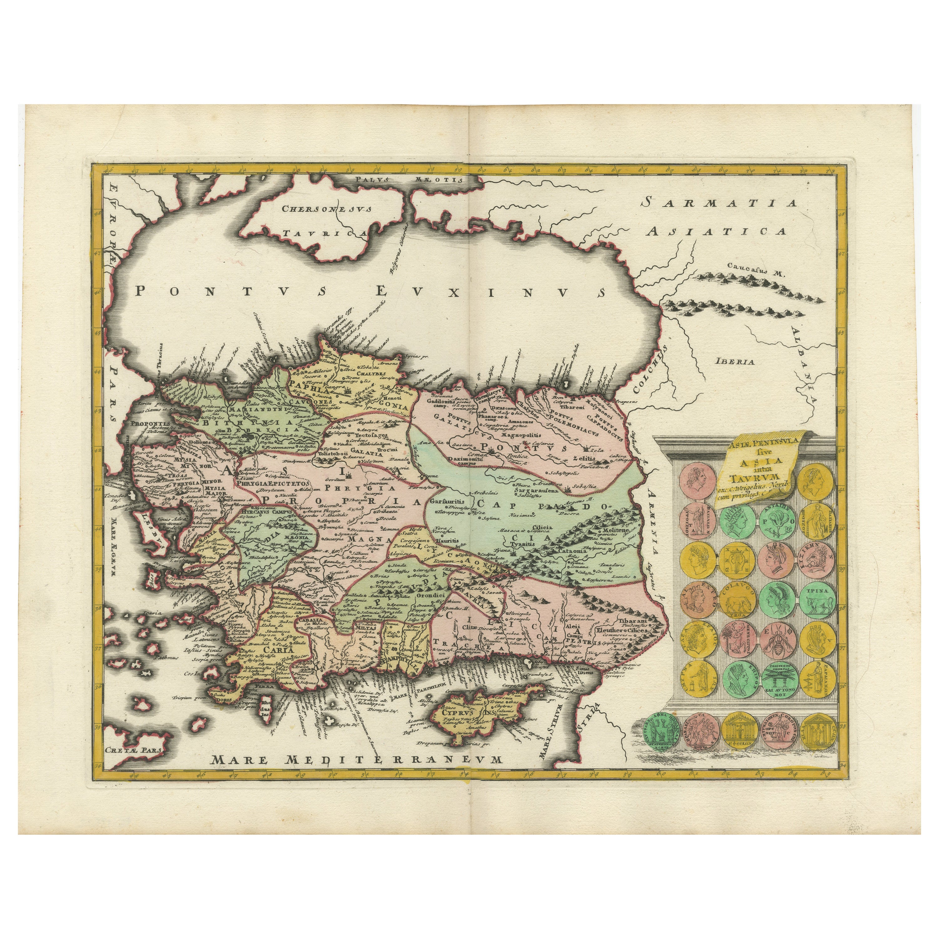
Decorative Antique Map of Cyprus and Asia Minor by Christoph Weigel, Circa 1720
Located in Langweer, NL
Title: Asiae Peninsula sive Asia Intra Taurum by Christoph Weigel, Circa 1720 – Decorative Antique Map of Cyprus and Asia Minor
Description: Thi...
Category
Antique 1720s Maps
Materials
Paper
$623 Sale Price
20% Off
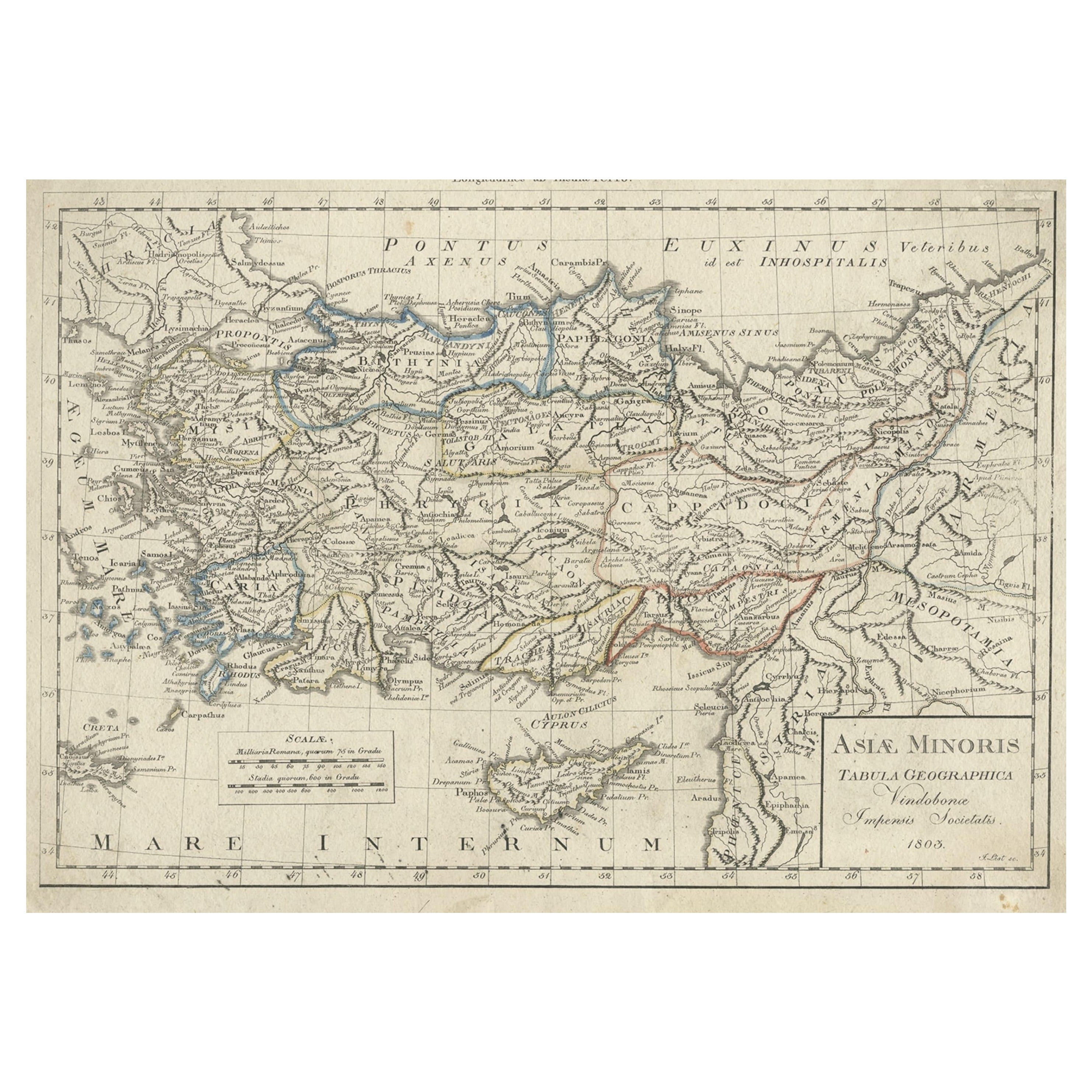
Antique Map of Asia Minor, Present-day Turkey and Cyprus, 1803
Located in Langweer, NL
Antique map titled 'Asiae Minoris Tabula Geographica'. Uncommon antique map of Asia minor, comprising most of what is present-day Turkey. Source unknown, to be determined.
Artists...
Category
Antique 19th Century Maps
Materials
Paper
$170 Sale Price
20% Off
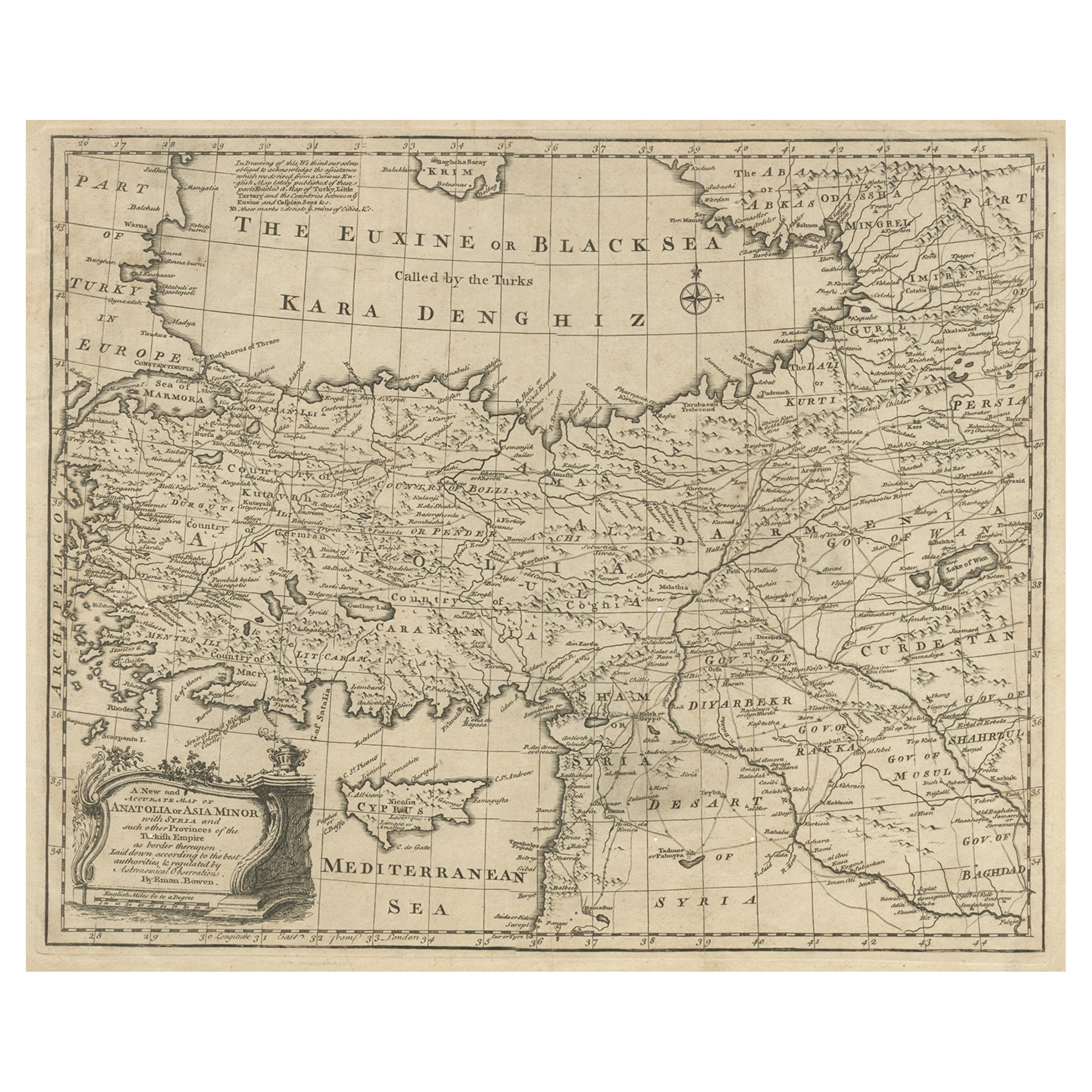
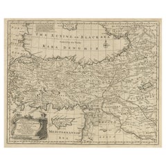
Antique Map of Asia Minor with Cyprus, Syria and Turkey and the Black Sea, 1747
Located in Langweer, NL
Antique map Middle East titled 'A New and accurate map of Anatolia or Asia Minor, with Syria and such other provinces of the Turkish Empire (.....
Category
Antique 18th Century Maps
Materials
Paper
$425 Sale Price
20% Off
You May Also Like
Original Antique Map of Ancient Greece, Achaia, Corinth, 1786
Located in St Annes, Lancashire
Great map of Ancient Greece. Showing the region of Thessaly, including Mount Olympus
Drawn by J.D. Barbie Du Bocage
Copper plate engraving by P.F Tardieu
Original hand color...
Category
Antique 1780s French Other Maps
Materials
Paper

Southern Greece: A Large 17th Century Hand-colored Map By Sanson and Jaillot
By Nicholas Sanson d'Abbeville
Located in Alamo, CA
This large original hand-colored copperplate engraved map of southern Greece and the Pelopponese Peninsula entitled "La Moree Et Les Isles De Zante, Cefalonie, Ste. Marie, Cerigo & C...
Category
1690s Landscape Prints
Materials
Engraving

18th Century Map of the Southern Balkans by Giovanni Maria Cassini
By Giovanni Maria Cassini
Located in Hamilton, Ontario
18th century map by Italian engraver Giovanni Maria Cassini (Italy 1745-1824).
Map of the Southern Balkans: Rome. Hand colored and copper engraved print done in the year 1788. It in...
Category
Antique 18th Century Italian Maps
Materials
Paper

$795 Sale Price
36% Off
Map of Greece - Original Etching by Antonio Zatta - 18th Century
Located in Roma, IT
This Map of Greece is an etching realized by Antonio Zatta, Cartographer, publisher and typographer.
The state of preservation of the artwork is good except for the worn paper and t...
Category
1780s Figurative Prints
Materials
Etching

Southern & Eastern Europe: A Large 17th C. Hand-colored Map by Sanson & Jaillot
By Nicholas Sanson d'Abbeville
Located in Alamo, CA
This large hand-colored map entitled "Estats de L'Empire des Turqs en Europe, ou sont les Beglerbeglicz our Gouvernements" was originally created by Nicholas Sanson d'Abbeville and this version was published by Hubert Jaillot in "Atlas Nouveau" in Paris in 1692. It depicts the territories of the Ottoman Empire in Europe, predominantly Eastern Europe. Highlights include, the Mediterranean Sea, the Adriatic Sea, the Black Sea, the Dalmation Coast including present day Croatia, Bosnia and Herzegovina, Montenegro, Serbia, Slovenia, Italy, Greece, North Macedonia, Turkey, Romania, Hungary, Albania, Kosovo, Bulgaria, Transylvania, Moldova and southern portions of France, Switzerland, Germany, and Poland..
The map consists of two sheets joined as one along a vertical joint. The map has original hand-coloring. It is printed on antique hand-made laid, chain-linked paper with wide margins. The sheet measures 24.88" high and 38" wide. There is a central vertical joint, as issued. The map is in very good condition.
Nicholas Sanson d'Abbeville (1600-1667) was one of the greatest French cartographather of French cartography. Sanson opened his first printing business in Paris in 1638. The king recognized his skill and knowledge and made him the official geographer to the court. He eventually served two kings in this capacity. Sanson was succeeded by his sons and son...
Category
1690s Landscape Prints
Materials
Engraving

17th Century Nicolas Visscher Map of Southeastern Europe
Located in Hamilton, Ontario
A beautiful, highly detailed map of southeastern Europe by Nicolas Visscher. Includes regions of Northern Italy (showing the cities Bologna, Padua, and Venice), Bohemia, Austria (sho...
Category
Antique 17th Century Dutch Maps
Materials
Paper

$1,350 Sale Price
38% Off
More Ways To Browse
17th Century Ottoman
Roman Tapestry
Sea Monster
Antique Tapestry Ottoman
Antique Crete
Antique German Tapestry
Tapestry With Cherubs
1960 Chair Wood Danish
Unusual Dining Table
Mdf Table
Showcase Coffee Table
Silver Ladle
Scalloped Table
Brazil Wood Chairs
Vintage Art Deco Side Tables
Window Display
1960s Cushion Chair
Green Brown Oriental Rug