Items Similar to Antique Map of Chinese and Independent Tartary, Korea and Japan, 1806


Want more images or videos?
Request additional images or videos from the seller
1 of 6
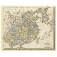
Antique Map of Chinese and Independent Tartary, Korea and Japan, 1806
$335.77
$419.7120% Off
£249.78
£312.2220% Off
€280
€35020% Off
CA$459.78
CA$574.7320% Off
A$511.22
A$639.0220% Off
CHF 266.93
CHF 333.6620% Off
MX$6,222.76
MX$7,778.4520% Off
NOK 3,405.90
NOK 4,257.3820% Off
SEK 3,191.17
SEK 3,988.9620% Off
DKK 2,131.49
DKK 2,664.3620% Off
Shipping
Retrieving quote...The 1stDibs Promise:
Authenticity Guarantee,
Money-Back Guarantee,
24-Hour Cancellation
About the Item
Antique map titled 'A New Map of Chinese & Independent Tartary'. Beautiful map of Chinese Tartary, Korea and Japan.
Artists and Engravers: John Cary (1755-1835) was a British cartographer and publisher best known for his clean engraving and distinct style which influenced the entire map industry.
Condition: Good, original/contemporary hand coloring. Minor defects from handling, please study image carefully.
Date: 1806
Overall size: 62 x 55.5 cm.
Image size: 50 x 46 cm.
We sell original antique maps to collectors, historians, educators and interior decorators all over the world. Our collection includes a wide range of authentic antique maps from the 16th to the 20th centuries. Buying and collecting antique maps is a tradition that goes back hundreds of years. Antique maps have proved a richly rewarding investment over the past decade, thanks to a growing appreciation of their unique historical appeal. Today the decorative qualities of antique maps are widely recognized by interior designers who appreciate their beauty and design flexibility. Depending on the individual map, presentation, and context, a rare or antique map can be modern, traditional, abstract, figurative, serious or whimsical. We offer a wide range of authentic antique maps for any budget.
- Dimensions:Height: 21.86 in (55.5 cm)Width: 24.41 in (62 cm)Depth: 0 in (0.01 mm)
- Materials and Techniques:
- Period:
- Date of Manufacture:1806
- Condition:
- Seller Location:Langweer, NL
- Reference Number:Seller: BGJC-1761stDibs: LU3054326145002
About the Seller
5.0
Recognized Seller
These prestigious sellers are industry leaders and represent the highest echelon for item quality and design.
Platinum Seller
Premium sellers with a 4.7+ rating and 24-hour response times
Established in 2009
1stDibs seller since 2017
2,511 sales on 1stDibs
Typical response time: <1 hour
- ShippingRetrieving quote...Shipping from: Langweer, Netherlands
- Return Policy
Authenticity Guarantee
In the unlikely event there’s an issue with an item’s authenticity, contact us within 1 year for a full refund. DetailsMoney-Back Guarantee
If your item is not as described, is damaged in transit, or does not arrive, contact us within 7 days for a full refund. Details24-Hour Cancellation
You have a 24-hour grace period in which to reconsider your purchase, with no questions asked.Vetted Professional Sellers
Our world-class sellers must adhere to strict standards for service and quality, maintaining the integrity of our listings.Price-Match Guarantee
If you find that a seller listed the same item for a lower price elsewhere, we’ll match it.Trusted Global Delivery
Our best-in-class carrier network provides specialized shipping options worldwide, including custom delivery.More From This Seller
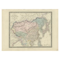
View AllAntique Map of China and Japan by Tardieu, 1821
Located in Langweer, NL
Antique map titled 'Carte de la Chine et du Japon'. Detailed map of China, showing Korea, Japan and Taiwan. This map originates from 'L'histoire général des voyages' by J.F. de la Harpe.
Category
Antique Early 19th Century Maps
Materials
Paper

$695 Sale Price
20% Off
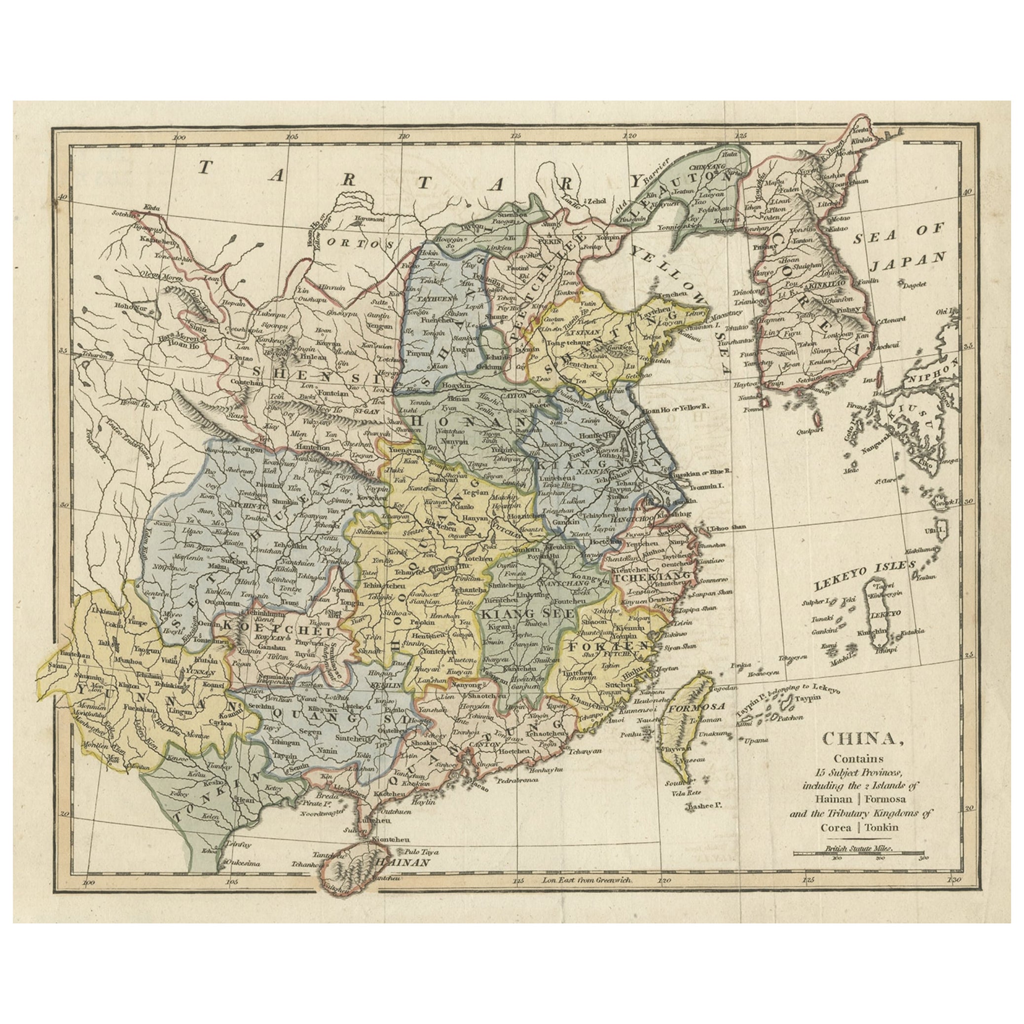
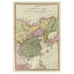
Original Old China Map, From Korea and the Sea of Japan to Teypin Island, 1803
Located in Langweer, NL
Antique map titled 'China, Contains 15 Subject Provinces Including the 2 Islands of Hainan, Formosa and the Tributary Kingdoms of Corea, Tonkin'.
Old map depicting China, extendi...
Category
Antique Early 1800s Maps
Materials
Paper
$527 Sale Price
20% Off
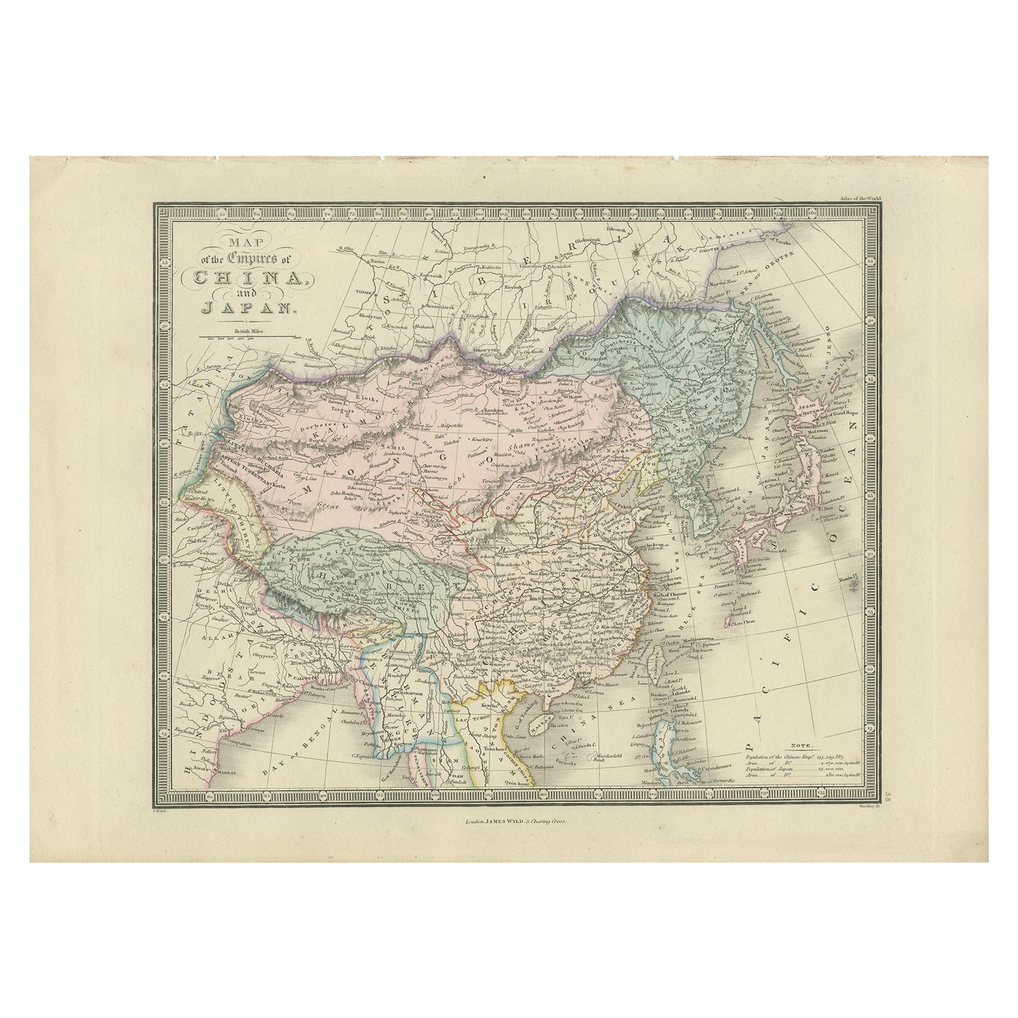
Antique Map of China and Japan by Wyld '1845'
Located in Langweer, NL
Antique map titled 'Map of the Empires of China and Japan'. Original antique map of China and Japan. This map originates from 'An Atlas of the World, Comprehending Separate Maps of i...
Category
Antique Mid-19th Century Maps
Materials
Paper
$215 Sale Price
40% Off
Decorative Map of the Empire of China, Korea, Japan, Taiwan, Lucon, Macau, 1780
Located in Langweer, NL
Antique map titled 'Carte de L'Empire de la Chine.'
Decorative map of the Empire of China, depicting China, Corea ( Korea ), Japan, Tonquin and the Philippine island Lucon. Source unknown, to be determined.
Artists and Engravers: Rigobert Bonne (1727-1795 ) was one of the most important cartographers of the late 18th century. In 1773 he succeeded Jacques Bellin as Royal Cartographer to France in the office of the Hydrographer at the Depôt de la Marine. Working in his official capacity Bonne compiled some of the most detailed and accurate maps of the period. Bonne's work represents an important step in the evolution of the cartographic ideology away from the decorative work of the 17th and early 18th century towards a more detail oriented and practical aesthetic. With regard to the rendering of terrain Bonne maps...
Category
Antique 1780s Maps
Materials
Paper
$623 Sale Price
20% Off
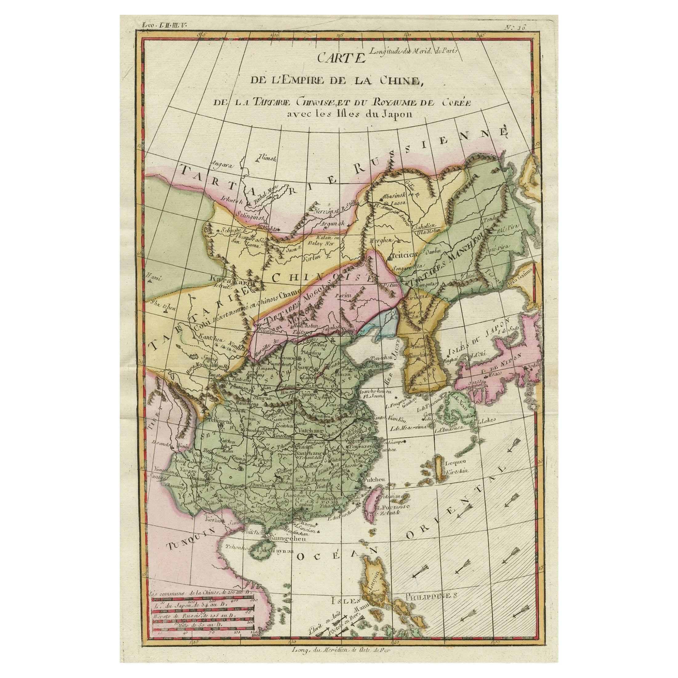
Antique Map of China, Korea, Japan and the Northern Philippines, circa 1780
Located in Langweer, NL
Antique map titled 'Carte de l'Empire de la Chine de la Tartarie Chinoise, et du Royaume de Corée'. Interesting and detailed map of China, Korea, Japan and the Northern Philippines. ...
Category
Antique Late 18th Century Maps
Materials
Paper

$287 Sale Price
20% Off
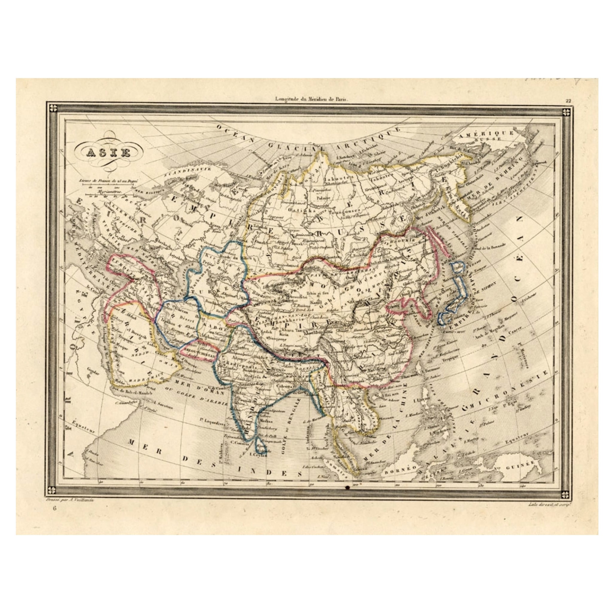
Antique Map of Asia, 1846
Located in Langweer, NL
Antique map titled 'Asie'. Original antique map of Asia. Source unknown, to be determined.
Artists and Engravers: Alexandre Vuillemin (1812-188...
Category
Antique 19th Century Maps
Materials
Paper
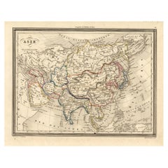
$74 Sale Price
20% Off
You May Also Like
Antique 1803 Italian Map of Asia Including China Indoneseia India
Located in Amsterdam, Noord Holland
Antique 1803 Italian Map of Asia Including China Indoneseia India
Very nice map of Asia. 1803.
Additional information:
Type: Map
Country of Manufacturing: Europe
Period: 19th centu...
Category
Antique 19th Century European Maps
Materials
Paper

$584 Sale Price
20% Off
Original Antique Map of China, Arrowsmith, 1820
Located in St Annes, Lancashire
Great map of China
Drawn under the direction of Arrowsmith
Copper-plate engraving
Published by Longman, Hurst, Rees, Orme and Brown, 1820
Unfr...
Category
Antique 1820s English Maps
Materials
Paper

Super Rare Antique French Map of Chine and the Chinese Empire, 1780
Located in Amsterdam, Noord Holland
Super Rare Antique French Map of Chine and the Chinese Empire, 1780
Very nice map of Asia. 1780 Made by Bonne.
Additional information:
Type: Map
...
Category
Antique 18th Century European Maps
Materials
Paper

$584 Sale Price
33% Off
Antique French Map of Asia Including China Indoneseia India, 1783
Located in Amsterdam, Noord Holland
Very nice map of Asia. 1783 Dedie au Roy.
Additional information:
Country of Manufacturing: Europe
Period: 18th century Qing (1661 - 1912)
Condition: Overall Condition B (Good Used)...
Category
Antique 18th Century European Maps
Materials
Paper

$648 Sale Price
20% Off
Large Original Vintage Map of China, circa 1920
Located in St Annes, Lancashire
Great map of China.
Original color. Good condition.
Published by Alexander Gross
Unframed.
Category
Vintage 1920s English Edwardian Maps
Materials
Paper

China: An Original 18th Century Hand-colored Map by E. Bowen
Located in Alamo, CA
This is an original 18th century hand-colored map entitled "A New & Accurate Map of China, Drawn from Surveys made by the Jesuit Missionaries, by order of the Emperor. The whole bein...
Category
Mid-18th Century Old Masters Landscape Prints
Materials
Engraving

More Ways To Browse
Japan Antiques Collectables
British Antique China
Korean Traditional Furniture
Antique Map Of Korea
Joan Blaeu
Antique Nautical Maps
Antique Portuguese Plates
New Zealand Map
Antique Railroad Collectibles
Blaeu World Map
Roman Empire Map
Antique Map Of Middle East
Caribbean Map
Antique Map Of Egypt
Antique Map Ortelius
Antique Farm Antiques Collectibles
Antique Galleon
Biblical Maps