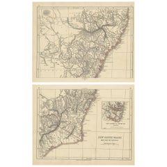
Items Similar to Antique Map Depicting Sydney and Surrounding Areas, Known as Port Jackson, c1889

Want more images or videos?
Request additional images or videos from the seller
1 of 9
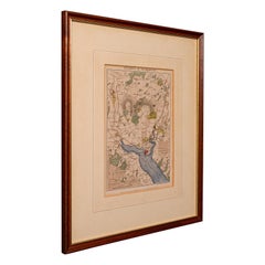
Antique Map Depicting Sydney and Surrounding Areas, Known as Port Jackson, c1889
$330.70
$413.3720% Off
£248.96
£311.2020% Off
€280
€35020% Off
CA$455.56
CA$569.4420% Off
A$510.19
A$637.7420% Off
CHF 266.21
CHF 332.7620% Off
MX$6,231.79
MX$7,789.7320% Off
NOK 3,386.97
NOK 4,233.7120% Off
SEK 3,192.63
SEK 3,990.7820% Off
DKK 2,131.40
DKK 2,664.2520% Off
About the Item
An antique map depicting Sydney and its surrounding areas, known as Port Jackson, dating from around 1889. It was produced by E. Reclus and is part of the "Nouvelle géographie universelle : la terre et les hommes," which translates to "New Universal Geography: The Earth and Its Inhabitants," published in Paris.
The map is a color-printed engraving, a common technique of the time, which allowed for both detailed cartographic information and attractive presentation. As noted, the map is in good condition with a center fold, which is typical for maps that were included in books or atlases.
The level of detail is significant, showing individual bays, points, and natural features, which suggests it was made for both navigational purposes and to provide a comprehensive overview of the Sydney region during the late 19th century. It extends from Manly in the north, Bondi in the south, and west to Ironstone Bay, which is not a commonly referenced area today and might be an historical name or a translation of a local name from that time.
The map is also an interesting artifact for those studying the historical geography of Sydney, as it shows the city before major 20th-century developments.
- Dimensions:Height: 10.16 in (25.8 cm)Width: 13.39 in (34 cm)Depth: 0 in (0.02 mm)
- Materials and Techniques:
- Period:
- Date of Manufacture:circa 1889
- Condition:In good condition, with centre fold as issued.
- Seller Location:Langweer, NL
- Reference Number:Seller: BG-13700-31stDibs: LU3054338389312
About the Seller
5.0
Recognized Seller
These prestigious sellers are industry leaders and represent the highest echelon for item quality and design.
Platinum Seller
Premium sellers with a 4.7+ rating and 24-hour response times
Established in 2009
1stDibs seller since 2017
2,533 sales on 1stDibs
Typical response time: <1 hour
- ShippingRetrieving quote...Shipping from: Langweer, Netherlands
- Return Policy
Authenticity Guarantee
In the unlikely event there’s an issue with an item’s authenticity, contact us within 1 year for a full refund. DetailsMoney-Back Guarantee
If your item is not as described, is damaged in transit, or does not arrive, contact us within 7 days for a full refund. Details24-Hour Cancellation
You have a 24-hour grace period in which to reconsider your purchase, with no questions asked.Vetted Professional Sellers
Our world-class sellers must adhere to strict standards for service and quality, maintaining the integrity of our listings.Price-Match Guarantee
If you find that a seller listed the same item for a lower price elsewhere, we’ll match it.Trusted Global Delivery
Our best-in-class carrier network provides specialized shipping options worldwide, including custom delivery.More From This Seller
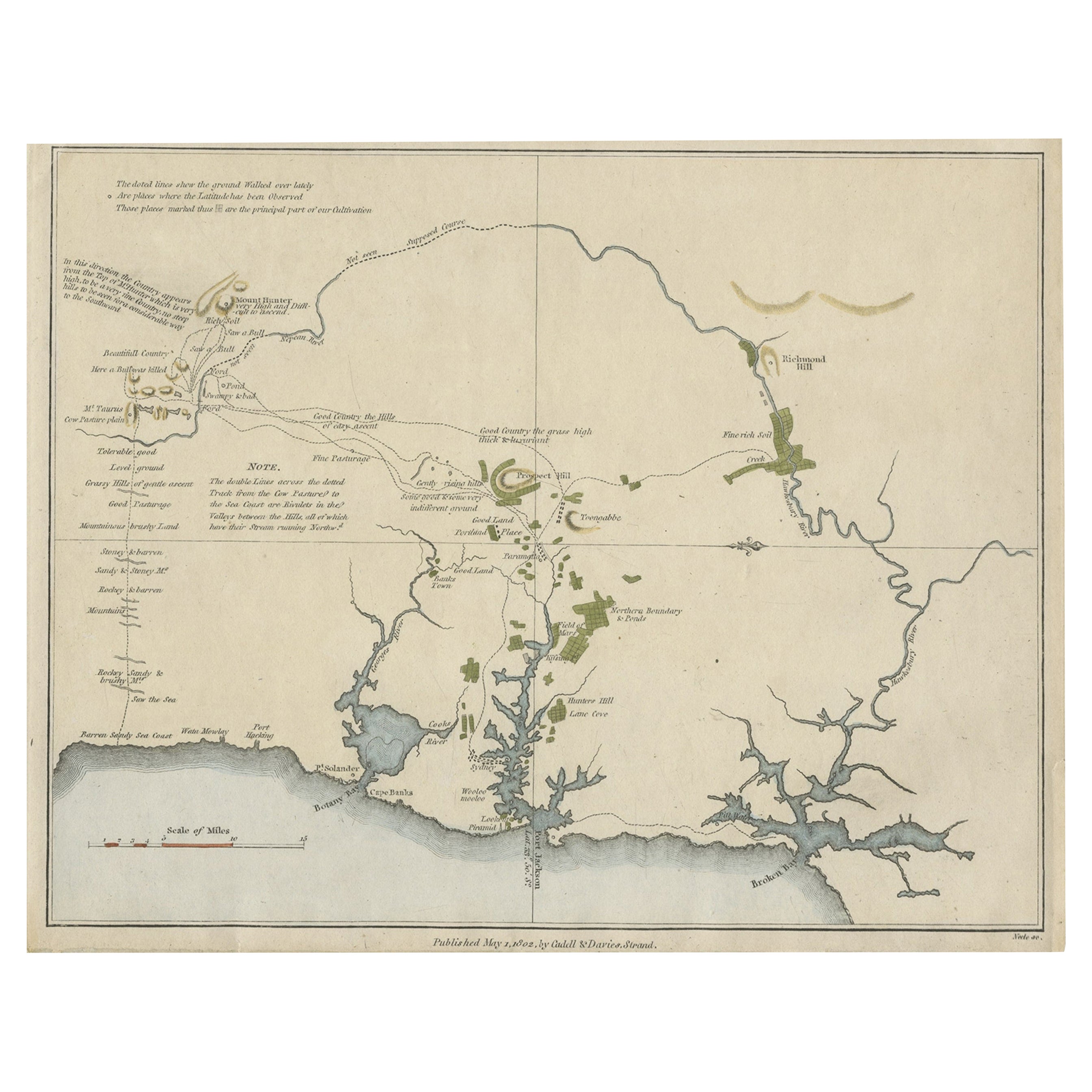
View AllEarly Map of Sydney with Botany Bay, Port Jackson & Broken Bay, Australia, 1802
Located in Langweer, NL
Interesting chart of the three harbours of Botany Bay, Port Jackson, and Broken Bay showing the ground cultivated by the colonists. In the early days of the settlement in Australia t...
Category
Antique Early 1800s Maps
Materials
Paper
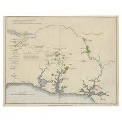
$1,067 Sale Price
20% Off
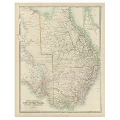
Antique Map of New South Wales 'Australia' by Wyld '1845'
Located in Langweer, NL
Antique map titled 'British Settlements in New South Wales'. Original antique map of New South Wales, Australia. This map originates from 'An Atlas of ...
Category
Antique Mid-19th Century Maps
Materials
Paper

$236 Sale Price
20% Off
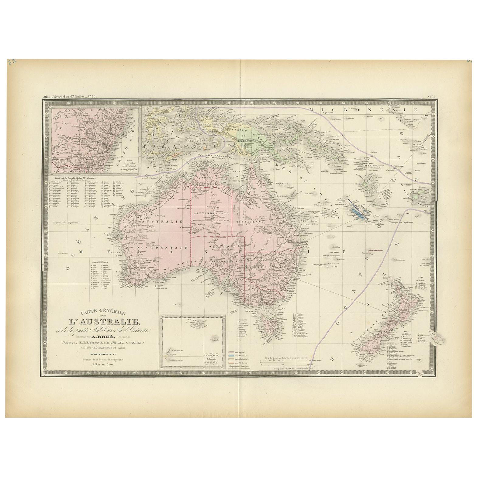
Antique Map of Australia by Levasseur, '1875'
Located in Langweer, NL
Antique map titled 'Carte générale de l'Australie'. Large map of Australia. This map originates from 'Atlas de Géographie Moderne Physique et Politiq...
Category
Antique Late 19th Century Maps
Materials
Paper

$413 Sale Price
30% Off
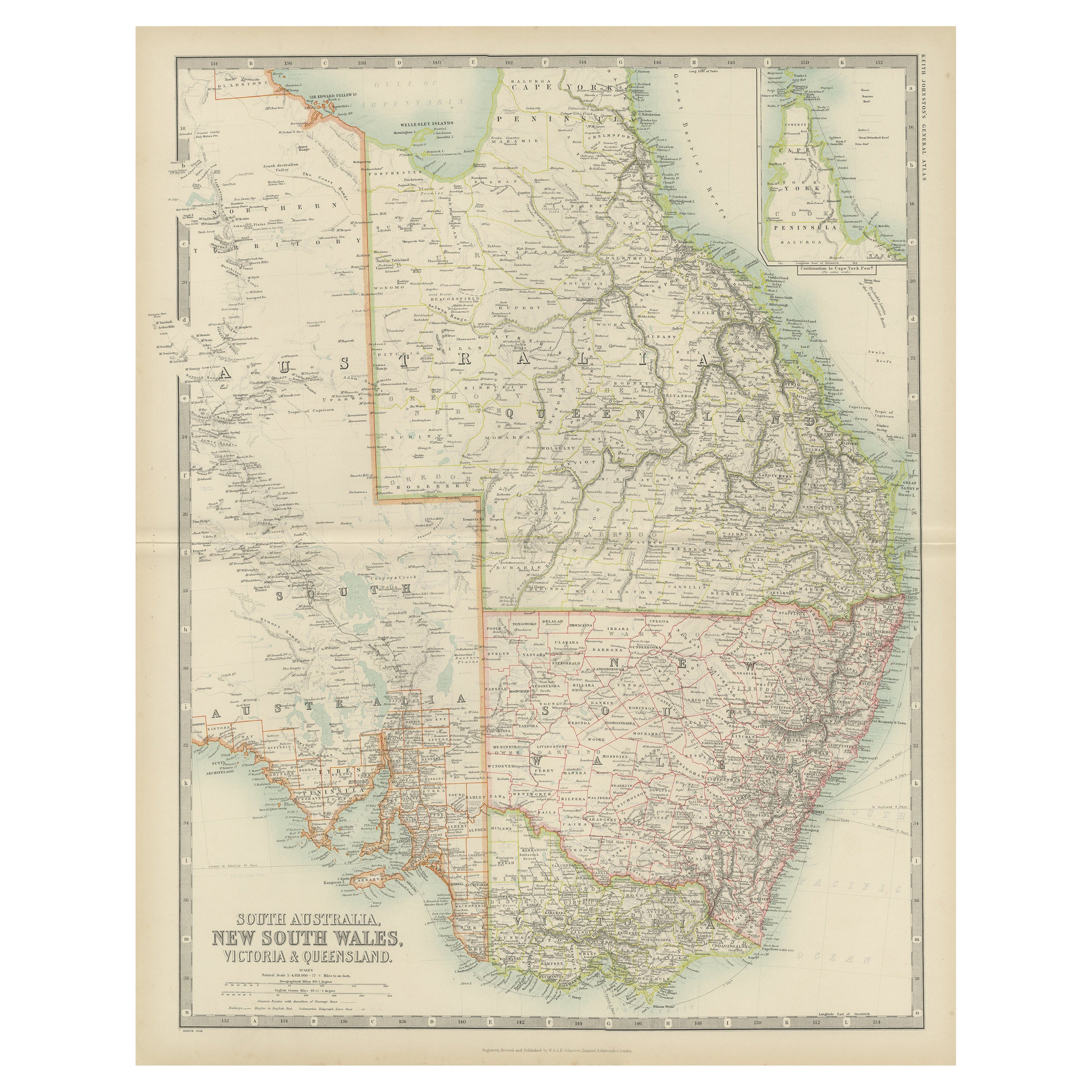
Antique Map of New South Wales by Johnston, '1909'
Located in Langweer, NL
Antique map titled 'South Australia, New South Wales, Victoria and Queensland'. Original antique map of New South Wales. With inset map of Cape York Pe...
Category
Early 20th Century Maps
Materials
Paper
$236 Sale Price
20% Off
Antique Map of New South Wales in Australia, ca. 1850
Located in Langweer, NL
Antique map of Victoria, or Port Phillip (12.7 x 10.0") in Australia. Superb map of Victoria roughly centered on Melbourne. Vignettes of Aborigines, a ...
Category
Antique Mid-19th Century European Maps
Materials
Paper

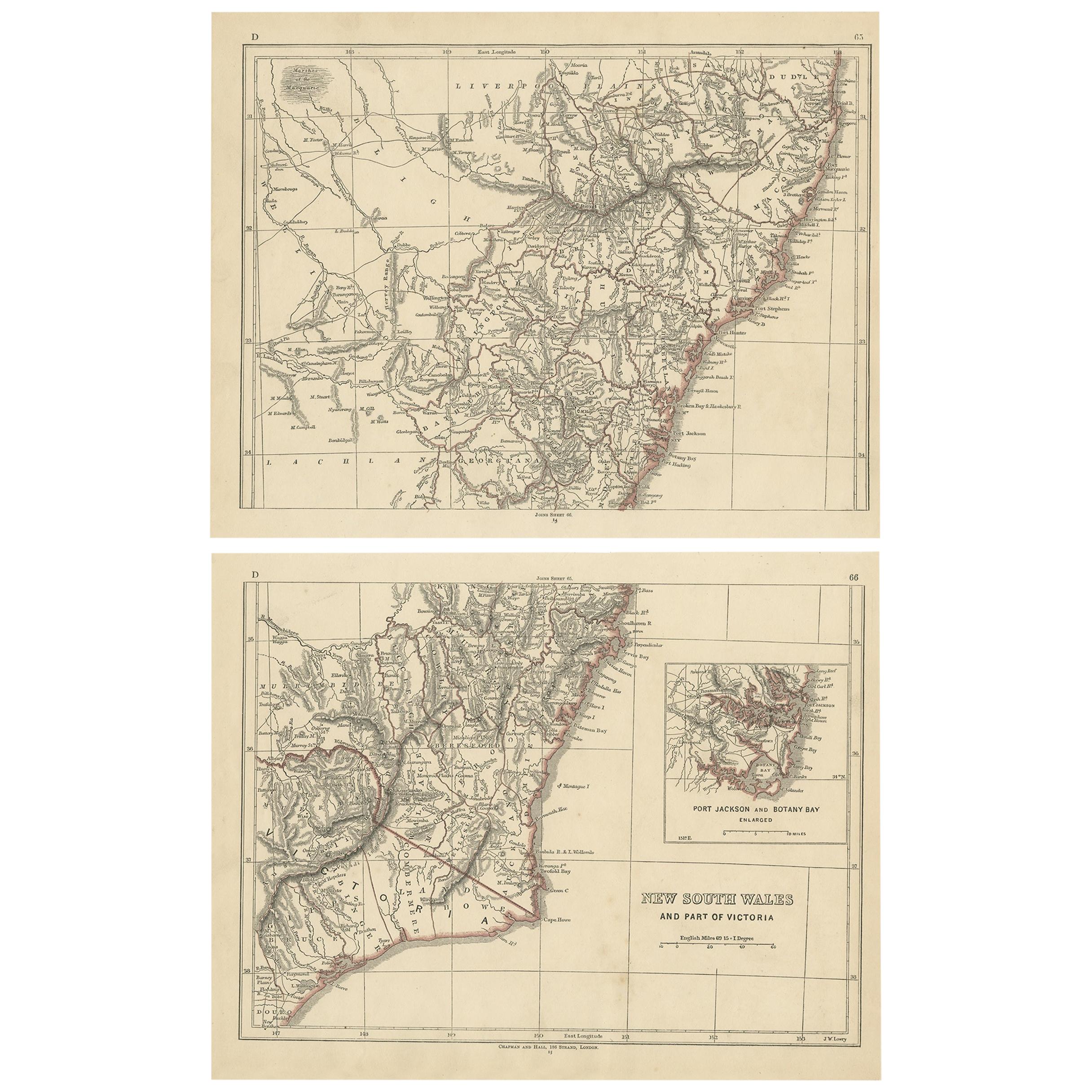
Antique Map of New South Wales by Lowry, 1852
Located in Langweer, NL
Antique map titled 'New South Wales and part of Victoria'. Two individual sheets of New South Wales and part of Victoria. This map originates from 'Low...
Category
Antique Mid-19th Century Maps
Materials
Paper
$141 Sale Price / set
20% Off
You May Also Like
Antique Map of American Cities, Vignette of New York City, circa 1920
Located in St Annes, Lancashire
Great maps of American Cities
Unframed
Original color
By John Bartholomew and Co. Edinburgh Geographical Institute
Published, circa 1920
Category
Vintage 1920s British Maps
Materials
Paper

Antique Lithography Map, Isle of Thanet, Kent, English, Cartography, Victorian
Located in Hele, Devon, GB
This is an antique lithography map of The Isle of Thanet in Kent. An English, framed atlas engraving of cartographic interest, dating to the mid 19th century and later.
Superb litho...
Category
Antique Mid-19th Century British Victorian Maps
Materials
Wood

Original Antique Map of New Brunswick and Nova Scotia, 1889
Located in St Annes, Lancashire
Great map of New Brunswick and Nova Scotia
Drawn and Engraved by W. & A.K. Johnston
Published By A & C Black, Edinburgh.
Original colour
Unfr...
Category
Antique 1880s Scottish Victorian Maps
Materials
Paper

Large Original Antique Map of The Falkland Islands. 1894
Located in St Annes, Lancashire
Superb Antique map of The Falkland Islands
Published Edward Stanford, Charing Cross, London 1894
Original colour
Good condition
Unframed.
Free shipping
Category
Antique 1890s English Maps
Materials
Paper

Antique Lithography Map, Environs of Southampton, English, Framed, Victorian
Located in Hele, Devon, GB
This is an antique lithography map 'The Environs of Southampton'. An English, framed town engraving of cartographic interest by John James Dower, dating to the Victorian period and ...
Category
Antique Late 19th Century British Victorian Maps
Materials
Wood
Large Original Antique Map of The Environs of Dublin, Ireland, circa 1880
Located in St Annes, Lancashire
Great map of The Environs of Dublin
Published circa 1880
Unframed
Free shipping.
Category
Antique 1880s Scottish Maps
Materials
Paper
More Ways To Browse
Antique Jackson
Used Furniture North Bay
Used Office Furniture Sydney
Early American Chairs
Hans Muller
Vintage Wood Table With Glass Top
19th Century Square Table
Antonio Bonet
Galle Chairs
Large Chinese Rug
1940s Vintage French Art Deco
20th Century Spanish Table
Antonio Bellini
Retro Fiberglass Furniture
Shipping Crate
Antique Oushak Carpets
Blue Coffee Tables
German Bauhaus Posters