Items Similar to Antique Map of the Distribution of Air and Rain by Reynolds, 1843


Want more images or videos?
Request additional images or videos from the seller
1 of 5
Antique Map of the Distribution of Air and Rain by Reynolds, 1843
$171.57
$214.4720% Off
£127.70
£159.6320% Off
€143.20
€17920% Off
CA$235.01
CA$293.7720% Off
A$261.39
A$326.7320% Off
CHF 136.49
CHF 170.6120% Off
MX$3,180.80
MX$3,97620% Off
NOK 1,743.16
NOK 2,178.9520% Off
SEK 1,634.78
SEK 2,043.4720% Off
DKK 1,090.13
DKK 1,362.6620% Off
Shipping
Retrieving quote...The 1stDibs Promise:
Authenticity Guarantee,
Money-Back Guarantee,
24-Hour Cancellation
About the Item
Two antique world maps on one sheet. The upper map shows the distribution of the currents of air and variable winds over the world. The lower meteorological map shows the distribution of the rain over the world. Originates from 'Geographical Diagrams '.
Artists and Engravers: Published by J. Reynolds, London.
Condition: Good, general age-related toning. Please study image carefully.
Date: 1843
Overall size: 22.7 x 28.5 cm.
Image size: 19.5 x 26.5 cm.
We sell original antique maps to collectors, historians, educators and interior decorators all over the world. Our collection includes a wide range of authentic antique maps from the 16th to the 20th centuries. Buying and collecting antique maps is a tradition that goes back hundreds of years. Antique maps have proved a richly rewarding investment over the past decade, thanks to a growing appreciation of their unique historical appeal. Today the decorative qualities of antique maps are widely recognized by interior designers who appreciate their beauty and design flexibility. Depending on the individual map, presentation, and context, a rare or antique map can be modern, traditional, abstract, figurative, serious or whimsical. We offer a wide range of authentic antique maps for any budget
- Dimensions:Height: 11.23 in (28.5 cm)Width: 8.94 in (22.7 cm)Depth: 0 in (0.01 mm)
- Materials and Techniques:
- Period:
- Date of Manufacture:1843
- Condition:
- Seller Location:Langweer, NL
- Reference Number:Seller: BG-08143-41stDibs: LU3054327796322
About the Seller
5.0
Recognized Seller
These prestigious sellers are industry leaders and represent the highest echelon for item quality and design.
Platinum Seller
Premium sellers with a 4.7+ rating and 24-hour response times
Established in 2009
1stDibs seller since 2017
2,502 sales on 1stDibs
Typical response time: <1 hour
- ShippingRetrieving quote...Shipping from: Langweer, Netherlands
- Return Policy
Authenticity Guarantee
In the unlikely event there’s an issue with an item’s authenticity, contact us within 1 year for a full refund. DetailsMoney-Back Guarantee
If your item is not as described, is damaged in transit, or does not arrive, contact us within 7 days for a full refund. Details24-Hour Cancellation
You have a 24-hour grace period in which to reconsider your purchase, with no questions asked.Vetted Professional Sellers
Our world-class sellers must adhere to strict standards for service and quality, maintaining the integrity of our listings.Price-Match Guarantee
If you find that a seller listed the same item for a lower price elsewhere, we’ll match it.Trusted Global Delivery
Our best-in-class carrier network provides specialized shipping options worldwide, including custom delivery.More From This Seller
View AllAntique Map Showing the Distribution of the Currents of Air by Johnston '1850'
Located in Langweer, NL
Antique map titled 'Geographical Distribution of the Currents of Air'. Original antique map showing the distribution of the currents of air. This map originates from 'The Physical At...
Category
Antique Mid-19th Century Maps
Materials
Paper

$191 Sale Price
20% Off
Antique Rain Map of the World by Johnston '1850'
Located in Langweer, NL
Antique map titled 'Hyetographic or Rain Map of the World'. Original antique rain map of the world. This map originates from 'The Physical Atlas of Natural Phenomena' by A.K. Johnsto...
Category
Antique Mid-19th Century Maps
Materials
Paper

$191 Sale Price
20% Off
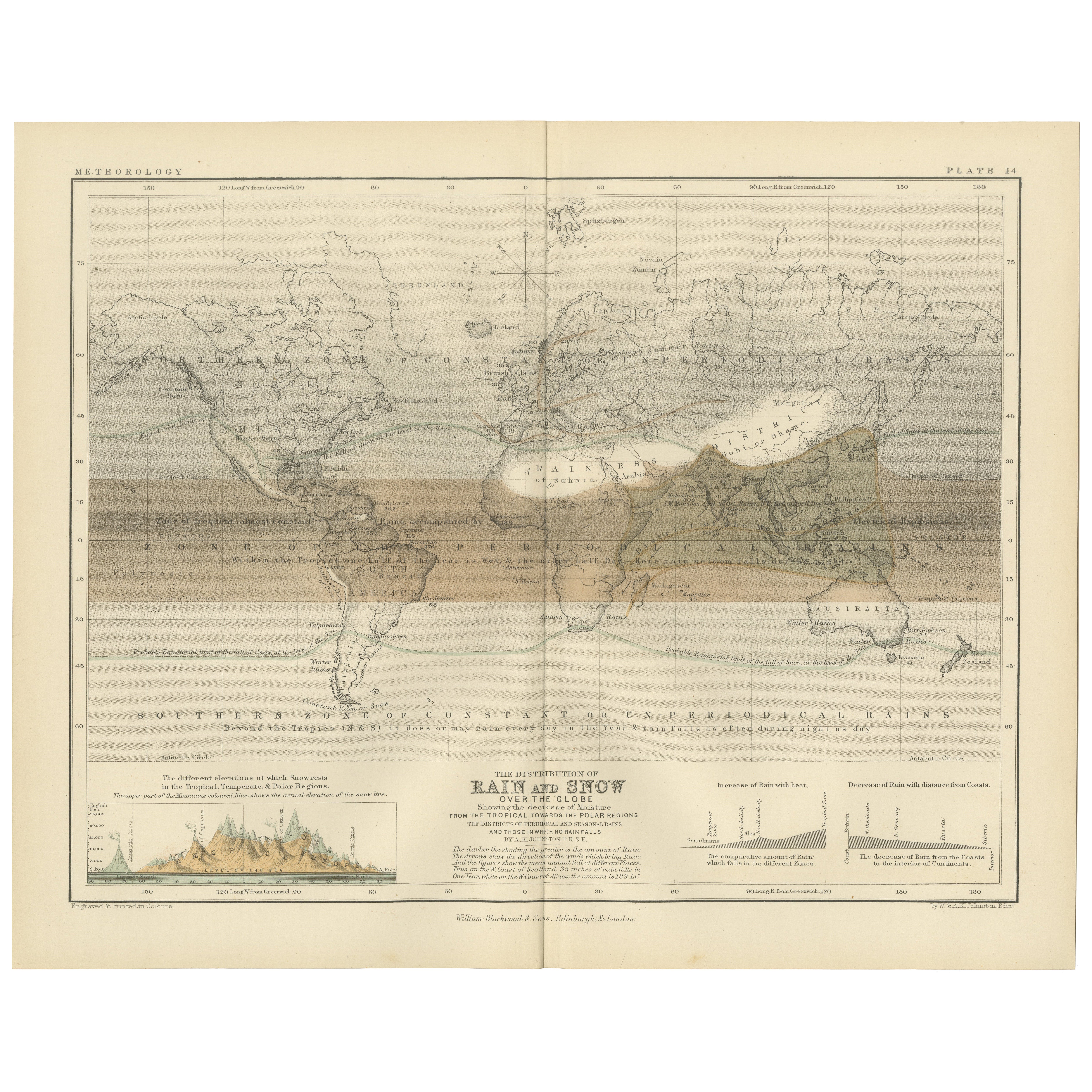
Rain and Snow Map by A.K. Johnston – Global Precipitation Chart 1852
Located in Langweer, NL
Rain and Snow Map by A.K. Johnston – Global Precipitation Chart 1852
This antique meteorological chart titled "The Distribution of Rain and Snow over the Globe" was created by Alexa...
Category
Antique Mid-19th Century Scottish Prints
Materials
Paper
Antique Map of the World Showing the Distribution of Plants and Minerals, 1872
Located in Langweer, NL
Antique map titled 'Johnson's World showing the distribution of the Characteristic Forest Trees (..)'. Original world map showing the distribution o...
Category
Antique Late 19th Century Maps
Materials
Paper

$191 Sale Price
20% Off
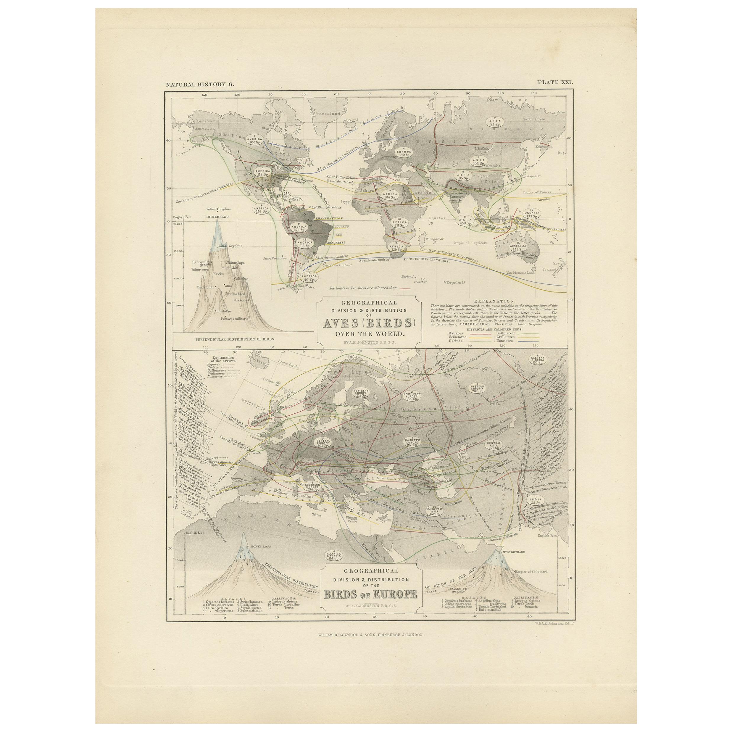
Antique Map Showing the Division and Distribution of Birds by Johnston '1850'
Located in Langweer, NL
Antique map titled 'Geographical division and distribution of birds over the world and birds of Europe'. Original antique map showing the geographical ...
Category
Antique Mid-19th Century Maps
Materials
Paper
$191 Sale Price
20% Off
Antique Map showing Isotherm Lines throughout the World by Johnston '1850'
Located in Langweer, NL
Antique map titled 'Humboldt's System of Isothermal Lines'. Original antique map showing isotherm lines throughout the world. This map originates from 'The Physical Atlas of Natural ...
Category
Antique Mid-19th Century Maps
Materials
Paper

$191 Sale Price
20% Off
You May Also Like
Original Antique Map of The World by Thomas Clerk, 1817
Located in St Annes, Lancashire
Great map of The Eastern and Western Hemispheres
On 2 sheets
Copper-plate engraving
Drawn and engraved by Thomas Clerk, Edinburgh.
Published by Mackenzie And Dent, 1817
...
Category
Antique 1810s English Maps
Materials
Paper

1864 Original illustrated planisphere - World Map - Geography
Located in PARIS, FR
Immerse yourself in the epic journey of the past with the Illustrated Historical Planisphere of 1864 by Charpentier! 🗺️ This cartographic treasure transports you through the intrica...
Category
1860s Prints and Multiples
Materials
Linen, Lithograph, Paper

Original Antique Map of The Western Hemisphere by Dower, circa 1835
Located in St Annes, Lancashire
Nice map of the Western Hemisphere
Drawn and engraved by J.Dower
Published by Orr & Smith. C.1835
Unframed.
Free shipping
Category
Antique 1830s English Maps
Materials
Paper

1864 Johnson's Map of the World on Mercator's Projection, Ric.B009
Located in Norton, MA
An 1864 Johnson's map of
the World on Mercator's Projection
Ric.b009
About this Item
"This antique map came from Johnson's New Illustrated (Steel Plate) Family Atlas, publ...
Category
Antique 19th Century Dutch Maps
Materials
Paper

Hemisphere Of The New Continent - Ancient Map by J.G. Heck - 1834.
By Johann Georg Heck
Located in Roma, IT
Hemisphere Of The New Continent is an artwork realized around 1760 by Johann Georg Heck
Original colored print.
Good conditions except for yellowing of paper and tears along the m...
Category
1830s Modern Figurative Prints
Materials
Etching

Large Original Antique Map of The World, Fullarton, C.1870
Located in St Annes, Lancashire
Great map of the World. Showing both hemispheres
From the celebrated Royal Illustrated Atlas
Lithograph. Original color.
Published by Fullarton, Edinburgh, C.1870
Unframed.
Rep...
Category
Antique 1870s Scottish Maps
Materials
Paper

More Ways To Browse
Map Of Normandy
Bali Map
Croatia Map
Gibraltar Antique Map
Albania Antique Map
Antique Furniture Kingston
Antique Louisiana Map
Armenia Map
L Tardieu
Chinese Wall Pocket
18th Century Nautical Engraving
Antique Map Burgundy
Antique Map By Coronelli
Antique Maps Singapore
Constantinople Map
Iraq Map
Mughal Map
Map Of Palestine