Items Similar to Antique Map of Europe in the 12th Century - Malte-Brun & Sarrazin, 1880


Want more images or videos?
Request additional images or videos from the seller
1 of 7
Antique Map of Europe in the 12th Century - Malte-Brun & Sarrazin, 1880
$119.81
£89.18
€100
CA$164.12
A$182.53
CHF 95.31
MX$2,221.23
NOK 1,217.29
SEK 1,141.60
DKK 761.27
Shipping
Retrieving quote...The 1stDibs Promise:
Authenticity Guarantee,
Money-Back Guarantee,
24-Hour Cancellation
About the Item
Title: Antique Map of Europe in the 12th Century - Malte-Brun & Sarrazin, 1880
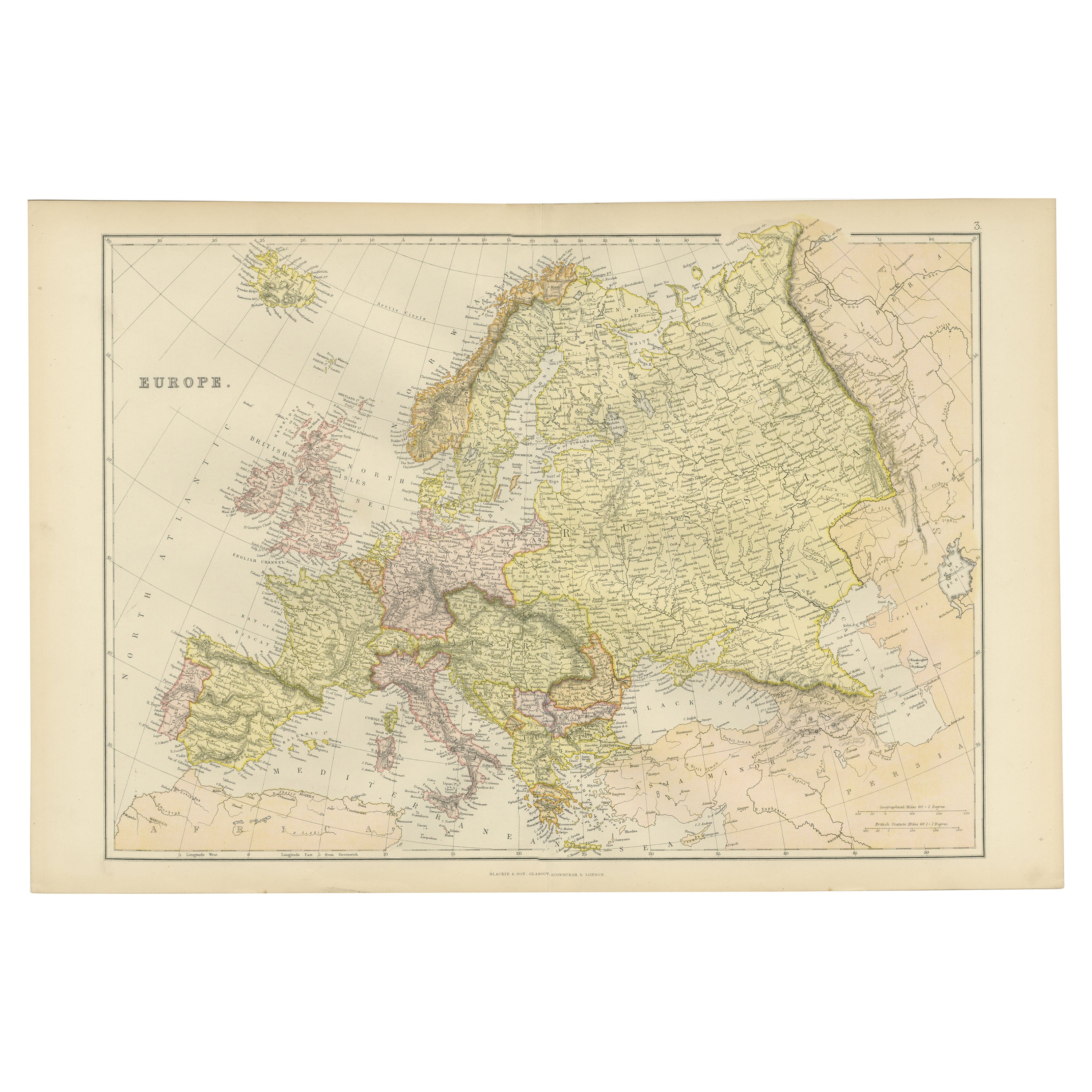
Description: This is an antique map titled "Europe en 1100," depicting Europe as it was around the 12th century. Published in 1880 by P. Garnier in France, the map was part of the work "Atlas de la Geographie Universelle ou Description de toutes les parties du monde" by Malte-Brun and Huot. The detailed lithographic work was done by Pierre Sarrazin, and it provides a fascinating visual history of medieval Europe, highlighting the political boundaries and the various states during this era.
Conrad Malte-Brun, originally from Denmark and later a notable figure in France, was a prominent geographer of his time, known for his comprehensive geographical works. His contributions to the field of cartography are continued by his son, Victor Adolphe Malte-Brun.
Condition:
Good. The map shows general age-related toning and light soiling, typical of antique paper from the late 19th century, but overall well-preserved for its age.
- Dimensions:Height: 11.03 in (28 cm)Width: 16.15 in (41 cm)Depth: 0.01 in (0.2 mm)
- Materials and Techniques:
- Period:
- Date of Manufacture:1880
- Condition:Good. The map shows general age-related toning and light soiling, typical of antique paper from the late 19th century, but overall well-preserved for its age.
- Seller Location:Langweer, NL
- Reference Number:Seller: BG-13840-41stDibs: LU3054342584082
About the Seller
5.0
Recognized Seller
These prestigious sellers are industry leaders and represent the highest echelon for item quality and design.
Platinum Seller
Premium sellers with a 4.7+ rating and 24-hour response times
Established in 2009
1stDibs seller since 2017
2,508 sales on 1stDibs
Typical response time: <1 hour
- ShippingRetrieving quote...Shipping from: Langweer, Netherlands
- Return Policy
Authenticity Guarantee
In the unlikely event there’s an issue with an item’s authenticity, contact us within 1 year for a full refund. DetailsMoney-Back Guarantee
If your item is not as described, is damaged in transit, or does not arrive, contact us within 7 days for a full refund. Details24-Hour Cancellation
You have a 24-hour grace period in which to reconsider your purchase, with no questions asked.Vetted Professional Sellers
Our world-class sellers must adhere to strict standards for service and quality, maintaining the integrity of our listings.Price-Match Guarantee
If you find that a seller listed the same item for a lower price elsewhere, we’ll match it.Trusted Global Delivery
Our best-in-class carrier network provides specialized shipping options worldwide, including custom delivery.More From This Seller
View AllAntique Map of the Europe Continent, 1880
Located in Langweer, NL
Antique map titled 'Europe'. Old map of the European continent. This map originates from 'Géographie Universelle Atlas-Migeon' by J. Migeon.
Artists an...
Category
Antique 19th Century Maps
Materials
Paper

$172 Sale Price
20% Off
Antique Map of Europe from an Old Dutch School-Atlas, 1852
Located in Langweer, NL
Antique map titled 'Europa'. Map of Europe. This map originates from 'School-Atlas van alle deelen der Aarde' by Otto Petri.
Artists and Engravers: Published by A. Baedeker (Otto...
Category
Antique 19th Century Maps
Materials
Paper

$134 Sale Price
20% Off
Antique Map of Europe by W. G. Blackie, 1859
Located in Langweer, NL
Antique map titled 'Europe'. Original antique map of Europe. This map originates from ‘The Imperial Atlas of Modern Geography’. Published by W. G. Blackie, 1859.
Category
Antique Mid-19th Century Maps
Materials
Paper

$239 Sale Price
20% Off
Antique Map of the European Continent, 1882
Located in Langweer, NL
Antique map titled 'Europe'. Old map of the European continent. This map originates from 'The Royal Atlas of Modern Geography, Exhibiting, in a Series of ...
Category
Antique 19th Century Maps
Materials
Paper

$129 Sale Price
20% Off
Colorful Detailed Antique Map of Europe, Published in 1882
Located in Langweer, NL
"The Antique Map of Europe from 'The Comprehensive Atlas and Geography of the World,' published in 1882 by Blackie & Son, is a testament to meticulous cartography and scholarly preci...
Category
Antique 1880s Maps
Materials
Paper
$182 Sale Price
20% Off
Antique Map of Europe by Johnson, '1872'
Located in Langweer, NL
Antique map titled 'Johnson's Europe'. Original map of Europe. This map originates from 'Johnson's New Illustrated Family Atlas of the World' by A.J. Johnson. Published 1872.
Category
Antique Late 19th Century Maps
Materials
Paper

$335 Sale Price
20% Off
You May Also Like
Large Original Antique Map of Europe by Sidney Hall, 1847
Located in St Annes, Lancashire
Great map of Europe
Drawn and engraved by Sidney Hall
Steel engraving
Original colour outline
Published by A & C Black. 1847
Unframed
Free shipping.
Category
Antique 1840s Scottish Maps
Materials
Paper

Original Antique Map of Europe, Arrowsmith, 1820
Located in St Annes, Lancashire
Great map of Europe
Drawn under the direction of Arrowsmith.
Copper-plate engraving.
Published by Longman, Hurst, Rees, Orme and Brown, 1820
...
Category
Antique 1820s English Maps
Materials
Paper

1790 Thomas Stackhouse Map, Entitled "Russia in Europe, " , Ric.a004
Located in Norton, MA
1790 Thomas Stackhouse map, entitled
"Russia in Europe"
Ric.a004
Stackhouse, Thomas
Russia in Europe [map]
London: T. Stackhouse, 1783. Map. Matted hand-colored copper engraving. Image size: 14.5 x 15.25 inches. Mat size: 22.75 x 23.75 inches. A beautiful example of this map of Eastern Europe...
Category
Antique 17th Century Unknown Maps
Materials
Paper

1849 Map of "Europaische Russland", 'Meyer Map of European Russia', Ric. R017
Located in Norton, MA
1849 Map of
"Europaische Russland"
( Meyer Map of European Russia)
Ric.r017
A lovely map of European Russia dating to 1849 by Joseph Meyer. It covers the European portions of...
Category
Antique 19th Century Unknown Maps
Materials
Paper

Large Original Antique Map of Poland by Sidney Hall, 1847
Located in St Annes, Lancashire
Great map of Poland
Drawn and engraved by Sidney Hall
Steel engraving
Original colour outline
Published by A & C Black. 1847
Unframed
...
Category
Antique 1840s Scottish Maps
Materials
Paper

1853 Map of "Russia in Europe Including Poland" Ric.r016
Located in Norton, MA
Description
Russia in Europe incl. Poland by J Wyld c.1853
Hand coloured steel engraving
Dimension: Paper: 25 cm W x 33 cm H ; Sight: 22 cm W x 28 cm H
Condition: Good ...
Category
Antique 19th Century Unknown Maps
Materials
Paper

More Ways To Browse
12th Century
12th Century Furniture
Le Brun
Pierre Garnier
Elios Chair
Plata Lappas
Red Retro Dining Set
Antique Bouquet
Antique Silver Glasses Case
Carlo Scarpa 1934 Chairs
Christofle Marly
1900 Antique Chairs
Glass Table Italian Round
Mid Century Colonial
Alvar Aalto Poster
Geometric Metal Table
Post Modern High Chairs
United Nations