Items Similar to Antique Map Featuring Turkey, Persia, India, Egypt & Arabia by James Wyld, 1839


Want more images or videos?
Request additional images or videos from the seller
1 of 6
Antique Map Featuring Turkey, Persia, India, Egypt & Arabia by James Wyld, 1839
$359.08
$448.8520% Off
£269.79
£337.2420% Off
€304
€38020% Off
CA$494.45
CA$618.0720% Off
A$553.38
A$691.7320% Off
CHF 289.68
CHF 362.1020% Off
MX$6,722.61
MX$8,403.2620% Off
NOK 3,678.16
NOK 4,597.6920% Off
SEK 3,470.97
SEK 4,338.7120% Off
DKK 2,313.74
DKK 2,892.1820% Off
About the Item
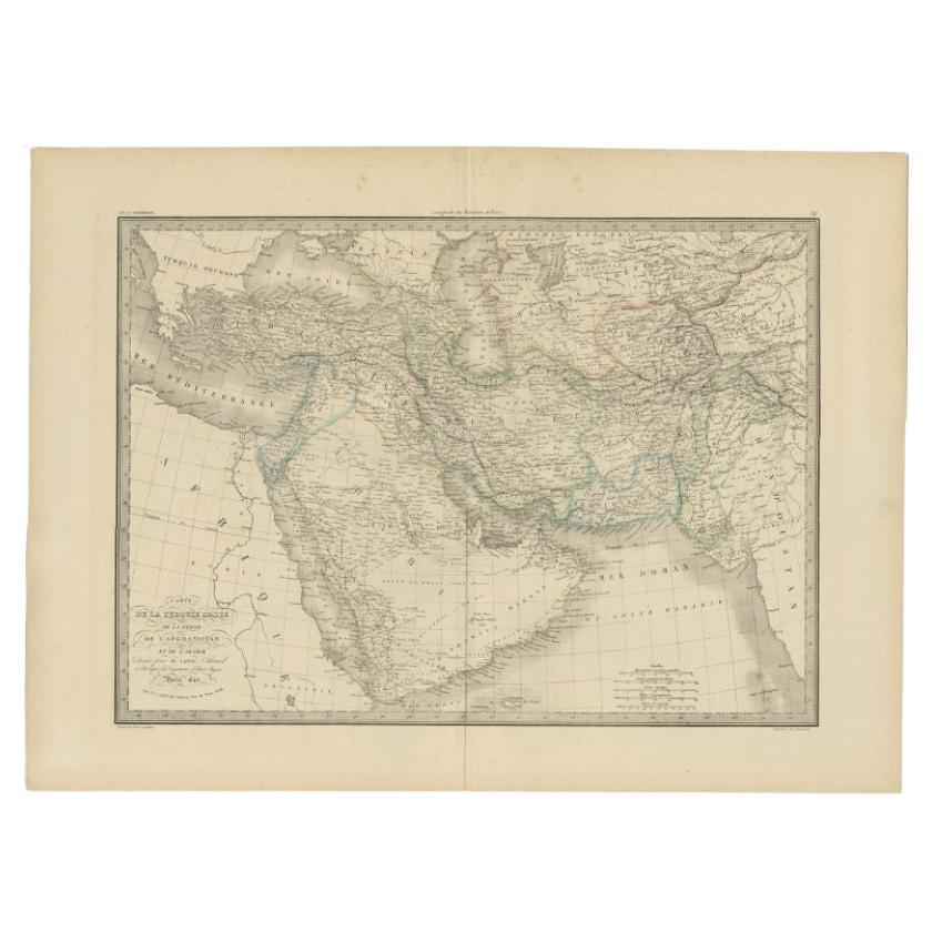
The map titled "Map of the countries lying between Turkey & Birmah, comprising Asia Minor, Persia, India, Egypt & Arabia and including the Black, Caspian & Red Seas" is an antique map created by James Wyld, Geographer to the Queen. Originally, this map was part of a four-sheet collection and provides a detailed geographical representation of a vast region stretching from Turkey to Burma (modern-day Myanmar).
Description:
- Title: Map of the countries lying between Turkey & Birmah, comprising Asia Minor, Persia, India, Egypt & Arabia and including the Black, Caspian & Red Seas.
- Creator: James Wyld, Geographer to the Queen.
- Features:
- **Geographical Coverage:** The map covers a large region including parts of modern-day Turkey, Iran (Persia), Iraq, Syria, Jordan, Israel, Saudi Arabia, Egypt, Pakistan, Afghanistan, India, and Myanmar.
- **Inclusions:** The map details significant water bodies such as the Black Sea, Caspian Sea, and Red Sea.
- **Insets:** The map includes two inset maps:
- **The Bosphorus:** Depicting the narrow, natural strait and internationally significant waterway located in northwestern Turkey, forming part of the boundary between Europe and Asia.
- **The Strait of the Dardanelles:** Showing the narrow strait in northwestern Turkey connecting the Aegean Sea to the Sea of Marmara.
Cartographic Elements:
- Borders: The map shows political boundaries, highlighted in various colors.
- Topography: Depicts physical features such as mountains, rivers, and lakes.
- Settlements: Cities and towns are marked, providing a view of human settlements within the region.
- Roads and Routes: Important travel routes and roads are indicated.
Historical Context:
This map, created by James Wyld, dates back to a period when cartographic efforts were crucial for navigation, trade, and geopolitical understanding. Wyld, known for his detailed and accurate maps, was a prominent figure in the field of geography and cartography in the 19th century.
Presentation:
- The map is finely detailed and engraved, reflecting the cartographic style and printing techniques of the 19th century.
- The original map was part of a larger set consisting of four sheets, but the provided image includes two parts of the complete map.
This map serves not only as a geographical tool but also as a historical artifact, offering insights into the geopolitical and cultural landscapes of the regions it covers during the time of its creation.
- Dimensions:Height: 16.74 in (42.5 cm)Width: 22.05 in (56 cm)Depth: 0 in (0.02 mm)
- Materials and Techniques:
- Period:
- Date of Manufacture:1839
- Condition:Good condition. A small tear touching the image on the middle left, hardly visible. General age-related toning and/or occasional minor defects from handling. Please study scan carefully.
- Seller Location:Langweer, NL
- Reference Number:Seller: BG-138011stDibs: LU3054340290102
About the Seller
5.0
Recognized Seller
These prestigious sellers are industry leaders and represent the highest echelon for item quality and design.
Platinum Seller
Premium sellers with a 4.7+ rating and 24-hour response times
Established in 2009
1stDibs seller since 2017
2,534 sales on 1stDibs
Typical response time: <1 hour
- ShippingRetrieving quote...Shipping from: Langweer, Netherlands
- Return Policy
Authenticity Guarantee
In the unlikely event there’s an issue with an item’s authenticity, contact us within 1 year for a full refund. DetailsMoney-Back Guarantee
If your item is not as described, is damaged in transit, or does not arrive, contact us within 7 days for a full refund. Details24-Hour Cancellation
You have a 24-hour grace period in which to reconsider your purchase, with no questions asked.Vetted Professional Sellers
Our world-class sellers must adhere to strict standards for service and quality, maintaining the integrity of our listings.Price-Match Guarantee
If you find that a seller listed the same item for a lower price elsewhere, we’ll match it.Trusted Global Delivery
Our best-in-class carrier network provides specialized shipping options worldwide, including custom delivery.More From This Seller
View AllAntique Map of Turkey in Asia by Wyld '1845'
Located in Langweer, NL
Antique map titled 'Map of Turkey in Asia'. Original antique map of Turkey in Asia. This map originates from 'An Atlas of the World, Comprehendin...
Category
Antique Mid-19th Century Maps
Materials
Paper

$188 Sale Price
20% Off
Turkey in Asia – Antique Ottoman Empire Map by John Tallis, ca. 1851
Located in Langweer, NL
Turkey in Asia – Antique Ottoman Empire Map by John Tallis, ca. 1851
This decorative 19th-century map titled "Turkey in Asia" was published by John Tallis & Company around 1851. Eng...
Category
Antique Mid-19th Century English Maps
Materials
Paper

Antique Map of Turkey, Persia and Afghanistan, 1842
By Pierre M. Lapie
Located in Langweer, NL
Antique map titled 'Carte de la Turquie d'Asia, de la Perse, de l'Afghanistan'. Map of Turkey, Persia and Afghanistan. This map originates from 'Atlas universel de géographie ancienn...
Category
Antique 19th Century Maps
Materials
Paper

$359 Sale Price
20% Off
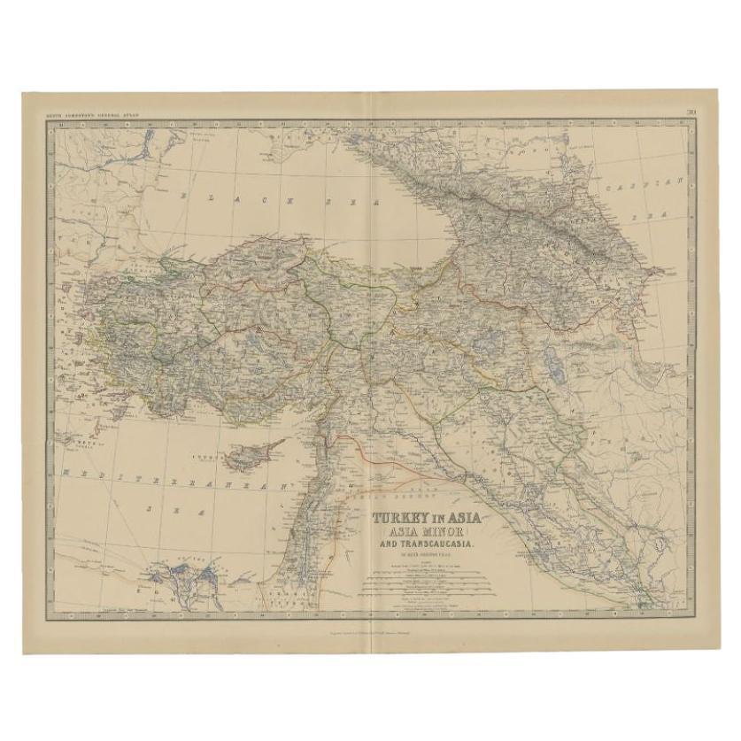
Antique Map of Turkey in Asia by A.K. Johnston, 1865
Located in Langweer, NL
Antique map titled 'Turkey in Asia (Asia Minor) and Transcaucasia'. This map originates from the ‘Royal Atlas of Modern Geography’ by Alexander Keith Johnston. Published by William B...
Category
Antique Mid-19th Century Maps
Materials
Paper
$259 Sale Price
20% Off
Antique Map of Turkey in Asia by A & C. Black, 1870
Located in Langweer, NL
Antique map titled 'Turkey in Asia'. Original antique map of Turkey in Asia with inset Ruins of Babylon. This map originates from ‘Black's General Atlas of The World’. Published by A...
Category
Antique Late 19th Century Maps
Materials
Paper

$165 Sale Price
20% Off
Antique Map of Turkey in Asia by Johnston, 1882
Located in Langweer, NL
Antique map titled 'Turkey in Asia (Asia Minor) and Transcaucasia'. Old map of Turkey in Asia (Asia Minor). This map originates from 'The Royal Atlas of Modern Geography, Exhibiting,...
Category
Antique 19th Century Maps
Materials
Paper
$368 Sale Price
20% Off
You May Also Like
Circa 1825 original engraving of the map of Syria by Giraldon Bovinet
Located in PARIS, FR
The circa 1825 original engraving of "Syrie" by Giraldon Bovinet, based on the work of L. Vivien, is a historically significant map that reflects early 19th-century cartographic tech...
Category
1820s Prints and Multiples
Materials
Engraving, Paper

1851 Map of "Independent Tartary", Ric. R018
Located in Norton, MA
1851 Map of
Independent Tartary
"Russia"
Ric.r018
A highly decorative 1851 map of Independent Tartary by John Tallis and John Rapkin. Covers the regions between the Caspian Sea and Lake Bakquash and between Russia and Afghanistan. These include the ancient Silk Route kingdoms of Khiva, Tartaria, Kokand, and Bokhara. Today this region roughly includes Kazakhstan, Uzbekistan, Turkmenistan, Kyrgyzstan, and Tajikistan. This wonderful map offers a wealth of detail for anyone with an interest in the Central Asian portion of the ancient Silk Road. Identifies various caravan routes, deserts, wells, and stopping points, including the cities of Bokhara and Samarkand. Three vignettes by W. Bragg decorate the map, these including an image of Tartars on a Journey, a horseback Bride Chase, and a tartar camp site. Surrounded by a vine motif border. Engraved by J. Rapkin for John Tallis's 1851 Illustrated Atlas .
Tartary Antique Map...
Category
Antique 19th Century Unknown Maps
Materials
Paper

Map Turkey in Europe & Hungary Thomas Kitchin, 1783
Located in BUNGAY, SUFFOLK
Thomas Kitchen (1718 - 1784) : Map of Turkey in Europe & Hungary 1783
Visible sheet within the cream mount 25.5cm., 10" height 20cm., 8"
In an ebonised frame length 33cm. 13", height 28cm., 11"
Kitchin, Thomas (1718 - 1784)
Thomas Kitchin (August 4, 1718 – June 23, 1784) was a London based engraver, cartographer, and publisher. He was born in London to a hat-dyer of the same name. At 14, Kitchin apprenticed under Emanuel Bowen, under whom he mastered the art of engraving. He married Bowen daughter, Sarah Bowen, and later inherited much of his preceptor's prosperous business. Their son, Thomas Bowen Kitchin, also an engraver joined the family business, which thereafter published in Thomas Kitchin and Son. From 1858 or so Kitchin was the engraver to the Duke of York, and from about 1773 acquired the title, 'Royal Hydrographer to King George III.' He is responsible for numerous maps published in the The Star, Gentleman's Magazine, and London Magazine, as well as partnering with, at various times, with Thomas Jefferys, Emmanuel Bowen, Thomas Hinton, Issac Tayor, Andrew Dury, John Rocque, Louis de la Rochette, and Alexander Hogg, among others. Kitchin passed his business on to his son, Thomas Bowen Kitchin, who continued to republish many of his maps well after his death. Kitchin's apprentices included George Rollos...
Category
Antique 18th Century English Georgian Maps
Materials
Paper

Large Original Antique Map of Afghanistan. Edward Weller, 1861
Located in St Annes, Lancashire
Great map of Afghanistan
Lithograph engraving by Edward Weller
Original colour
Published, 1861
Unframed
Good condition
Category
Antique 1860s English Victorian Maps
Materials
Paper

Original Antique Map of India by Dower, circa 1835
Located in St Annes, Lancashire
Nice map of India
Drawn and engraved by J.Dower
Published by Orr & Smith. C.1835
Unframed.
Free shipping
Category
Antique 1830s English Maps
Materials
Paper

1860 Large Map "Carte De La Siberie Russie D'asie, " Ric.R0001
Located in Norton, MA
Large 1860 map "Carte De La Siberie Russie D'Asie," R-0001
" Authentic" - 1860 map "Carte De La Siberie Russie D'Asie,"
Dimension: Paper: 68 cm W x 51 cm H ; Sight: 51cm W x 4...
Category
Antique 19th Century Unknown Maps
Materials
Paper

More Ways To Browse
Arabian Antique
Pakistan Antiques
Arabia Set
Iran Map
Burmese Offering
Arabian Syrian
Antique Oushak Carpets
Blue Coffee Tables
1945 Chair Juhl
Antique Three Leg Table
Folke Arstrom
Silver Over Copper
Vintage Barware Glasses
Antique Etched Glass
Antique French Shell
Coffee Table Black Italian Modern
Christofle America
Iranian Silk Rug Carpet