Items Similar to Antique Map of the Iberian Peninsula with two decorative Cartouches
Want more images or videos?
Request additional images or videos from the seller
1 of 6
Antique Map of the Iberian Peninsula with two decorative Cartouches
$1,427.71
$1,784.6320% Off
£1,058.01
£1,322.5120% Off
€1,192
€1,49020% Off
CA$1,949.09
CA$2,436.3620% Off
A$2,168.28
A$2,710.3520% Off
CHF 1,136.64
CHF 1,420.8020% Off
MX$26,495.88
MX$33,119.8520% Off
NOK 14,473.70
NOK 18,092.1320% Off
SEK 13,624.99
SEK 17,031.2420% Off
DKK 9,075.78
DKK 11,344.7320% Off
Shipping
Retrieving quote...The 1stDibs Promise:
Authenticity Guarantee,
Money-Back Guarantee,
24-Hour Cancellation
About the Item
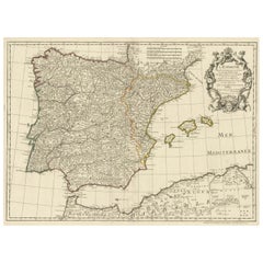
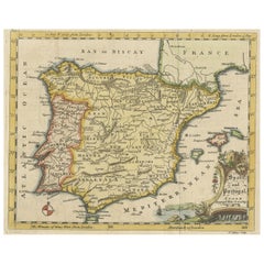
Antique map titled 'Hispaniae et Portugalliae Regna'. Original old map of the Iberian peninsula showing Spain, Portugal and the Balearic Islands. Two beautiful cartouches with several putti and coat of arms. Published by N. Visscher, circa 1680.
The Visscher family were art and map dealers in Amsterdam during the 17th century. Funded by C. J. Visscher (1587-1652), the business was continued by his son and grandson both named Nicolas. Nicolas Visscher I was born 1618 in Wenns, Austria. He died 1679 in Linz. After the death of Nicolas II, his widow passed the business to Pieter Schenk.
- Dimensions:Height: 20.36 in (51.7 cm)Width: 24.57 in (62.4 cm)Depth: 0.02 in (0.5 mm)
- Materials and Techniques:
- Period:Late 17th Century
- Date of Manufacture:c.1680
- Condition:Repaired: Original folding line, with existing splits and repairs. Age-related toning. Later hand coloring. Shows wear and creasing, also affecting image. Small tears in margins. Blank verso. Please study image carefully.
- Seller Location:Langweer, NL
- Reference Number:Seller: BG-13433-41stDibs: LU3054336227082
About the Seller
5.0
Recognized Seller
These prestigious sellers are industry leaders and represent the highest echelon for item quality and design.
Platinum Seller
Premium sellers with a 4.7+ rating and 24-hour response times
Established in 2009
1stDibs seller since 2017
2,502 sales on 1stDibs
Typical response time: <1 hour
- ShippingRetrieving quote...Shipping from: Langweer, Netherlands
- Return Policy
Authenticity Guarantee
In the unlikely event there’s an issue with an item’s authenticity, contact us within 1 year for a full refund. DetailsMoney-Back Guarantee
If your item is not as described, is damaged in transit, or does not arrive, contact us within 7 days for a full refund. Details24-Hour Cancellation
You have a 24-hour grace period in which to reconsider your purchase, with no questions asked.Vetted Professional Sellers
Our world-class sellers must adhere to strict standards for service and quality, maintaining the integrity of our listings.Price-Match Guarantee
If you find that a seller listed the same item for a lower price elsewhere, we’ll match it.Trusted Global Delivery
Our best-in-class carrier network provides specialized shipping options worldwide, including custom delivery.More From This Seller
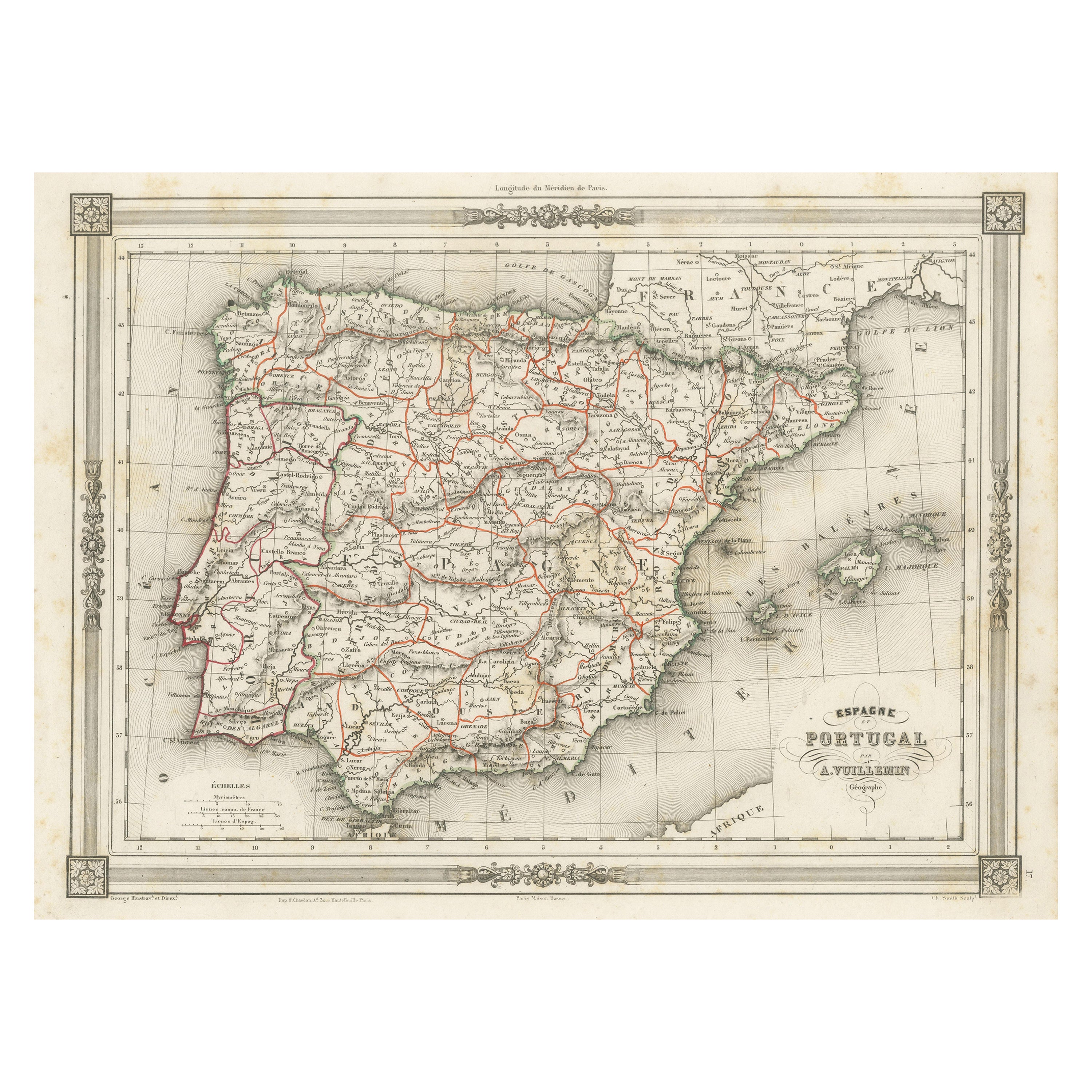
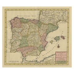
View AllAntique Map of Spain and Portugal, with Frame Style Border
Located in Langweer, NL
Antique map titled 'Espagne et Portugal'. Attractive map of Spain and Portugal. The map covers all of Spain and Portugal from France to the Mediterranean Sea and includes the Baleari...
Category
Antique Mid-19th Century Maps
Materials
Paper
$114 Sale Price
20% Off
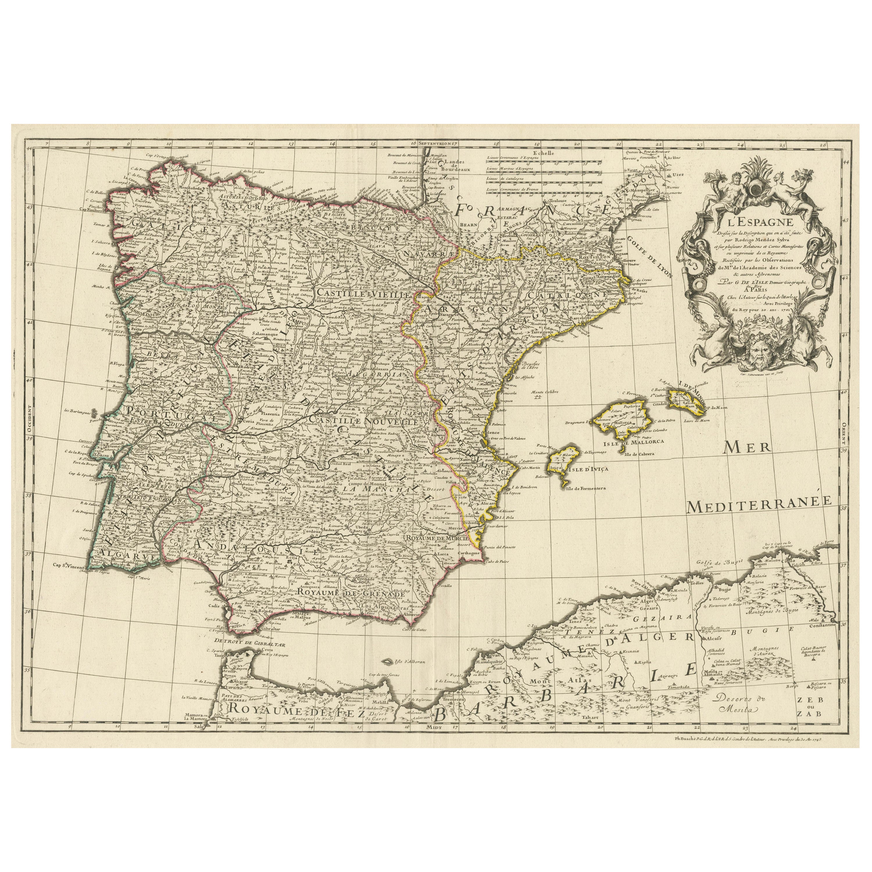
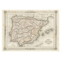
Large Decorative Map of the Iberian Peninsula
Located in Langweer, NL
Antique map titled 'L'Espagne (..)'. Large map of the Iberian Peninsula, including the Balearic Islands and part of the north coast of Africa. The map is based on the cartography of ...
Category
Antique Mid-18th Century Maps
Materials
Paper
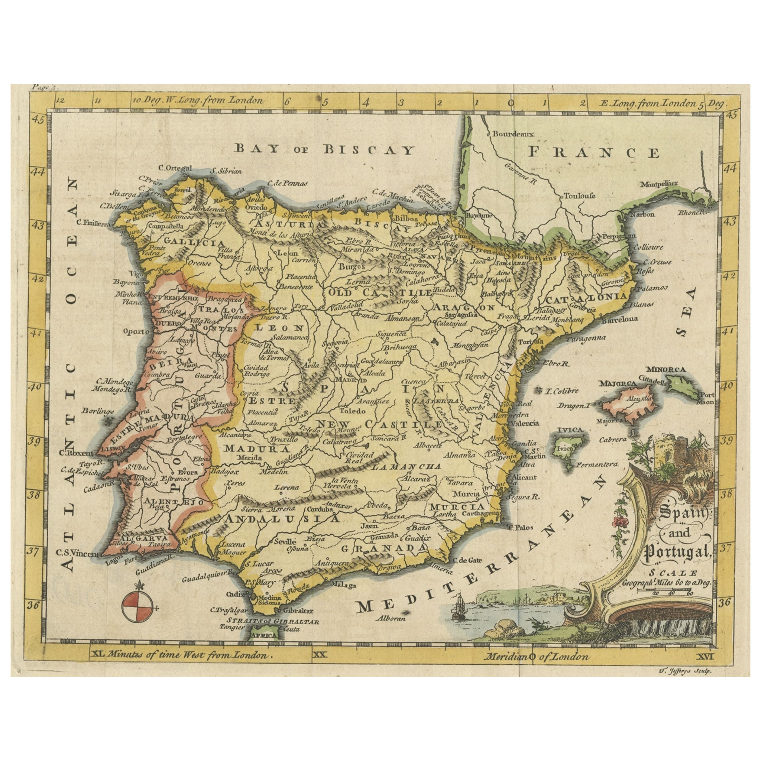
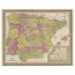
Antique Map of Spain & Portugal 'Iberian Peninsula', Decorative Cartouche, c1755
Located in Langweer, NL
Antique map titled 'Spain and Portugal'.
Small, detailed antique map of Spain and Portugal (Iberian Peninsula). Decorative title cartouche.
Artists and Engravers: Thomas Jeff...
Category
Antique 1750s Maps
Materials
Paper
$229 Sale Price
20% Off
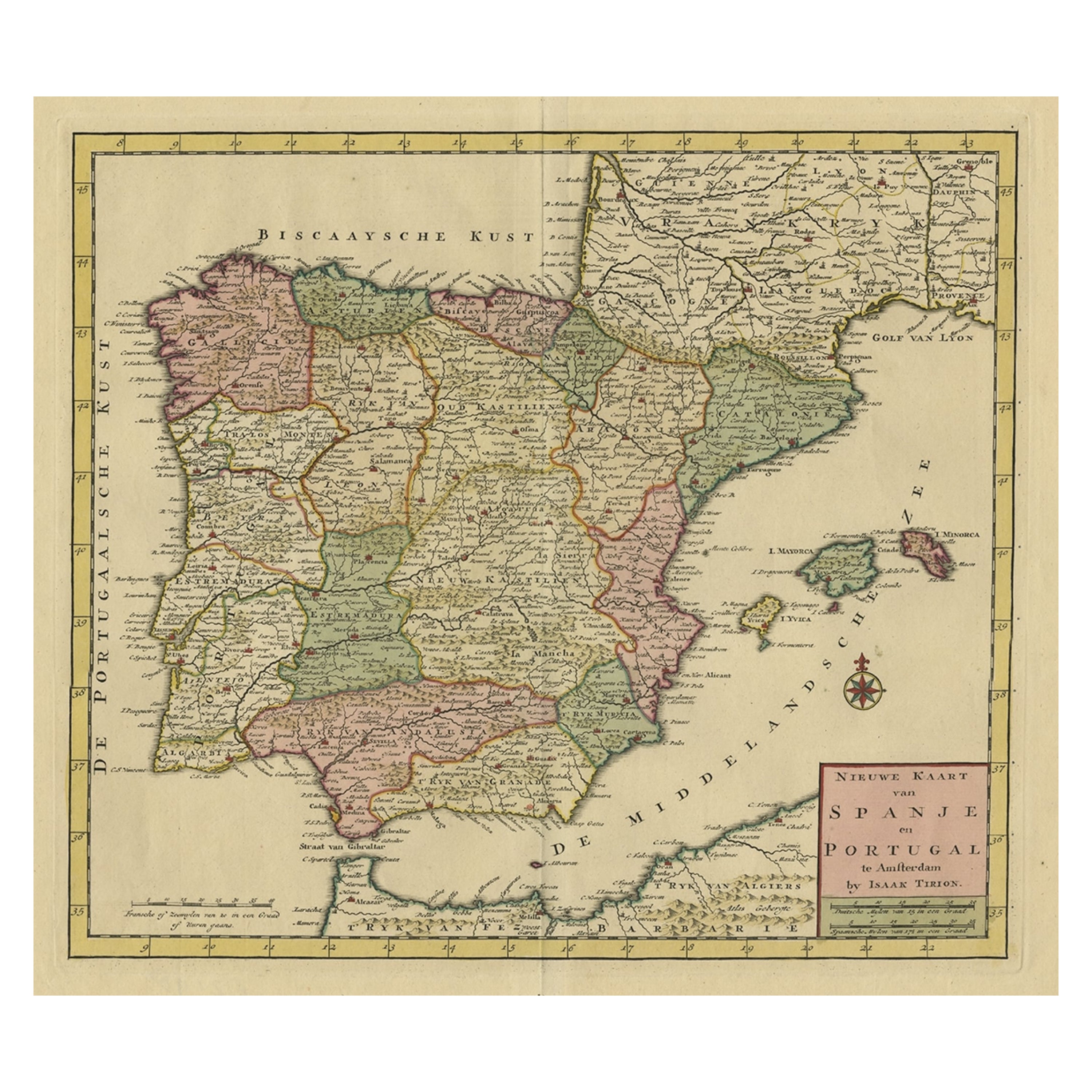
Detailed Old Map showing Spain and Portugal Incl. Majorca, Minorca & Ibiza, 1740
Located in Langweer, NL
Antique map titled 'Nieuwe Kaart van Spanje en Portugal.'
Attractive detailed map showing Spain and Portugal. Including Majorca, Minorca and Ibiza. Title in block-style cartouche...
Category
Antique 1740s Maps
Materials
Paper
$498 Sale Price
20% Off
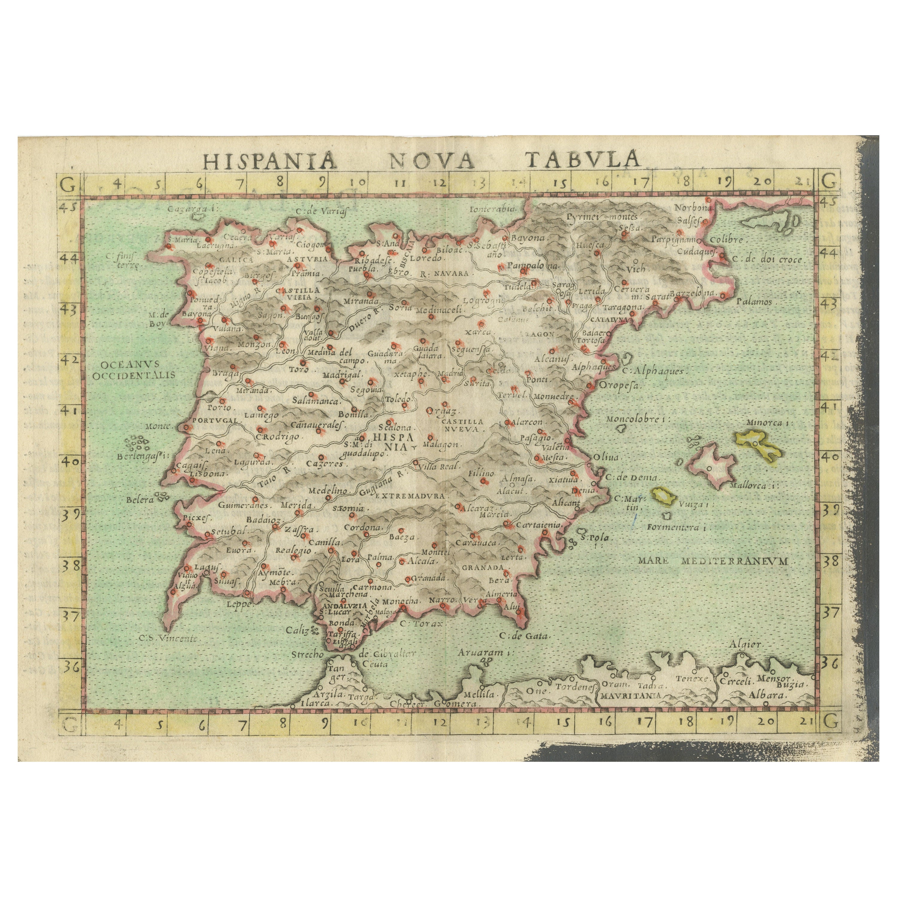
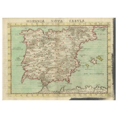
Antique Map of Spain including the Balearic Islands
Located in Langweer, NL
Antique map titled 'Hispania Nova Tabula'. Ruscelli's map of Spain, including the Balearic Islands. This map originates from 'Espositione & introduttioni universali di Gir. Ruscelli sopra tutta la Geografia di Tolomeo (..)' published by Girolamo Ruscelli, 1561.
Girolamo Ruscelli (1500-1566) was a cartographer, humanist, and scholar from Tuscany. Ruscelli was a prominent writer and editor in his time, writing about a wide variety of topics including the works of Giovanni Boccaccio and Francesco Petrarch, Italian language, Italian poetry, medicine, alchemy, and militia. One of his most notable works was a translation of Ptolemy’s Geographia...
Category
Antique 16th Century Maps
Materials
Paper
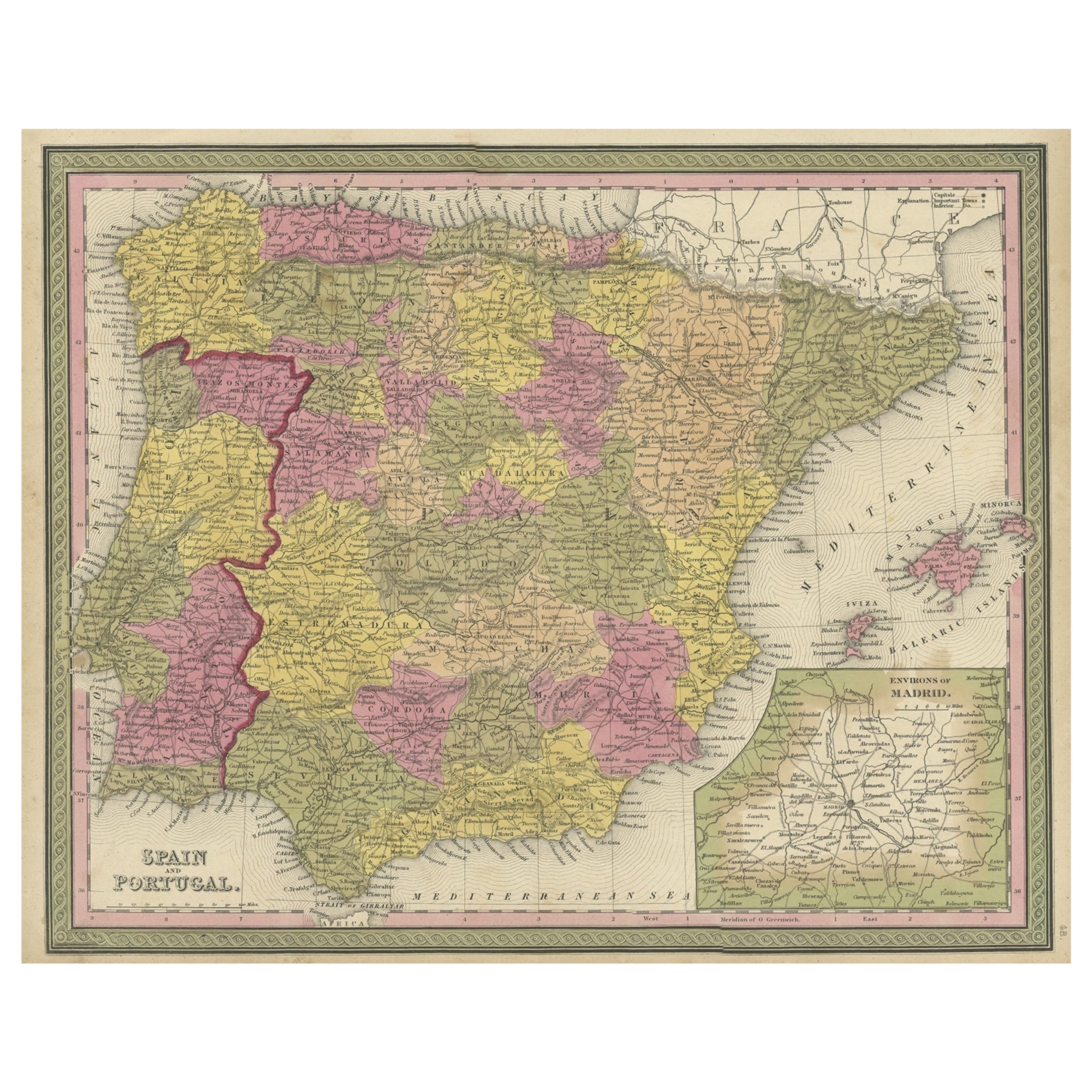
Old Map of Spain and Portugal, with an Inset Map of the Region of Madrid, 1846
Located in Langweer, NL
Antique map titled 'Kingdom of Spain and Portugal'.
Old map of Spain and Portugal, with an inset map of the region of Madrid. This map originates from 'A New Universal Atlas Cont...
Category
Antique 1840s Maps
Materials
Paper
$210 Sale Price
20% Off
You May Also Like
Original Antique Map of Spain and Portugal, circa 1790
Located in St Annes, Lancashire
Super map of Spain and Portugal
Copper plate engraving by A. Bell
Published, circa 1790.
Unframed.
Category
Antique 1790s English Other Maps
Materials
Paper

Large Original Vintage Map of Spain, circa 1920
Located in St Annes, Lancashire
Great map of Spain
Original color.
Good condition
Published by Alexander Gross
Unframed.
Category
Vintage 1920s English Maps
Materials
Paper

18th Century Hand Colored Map of Spain and Portugal by Visscher
By Nicolaes Visscher II
Located in Alamo, CA
This is an early 18th century map of Spain and Portugal, with attractive original hand-coloring, entitled "Hispaniae et Portugalliae Regna per Nicolaum Visscher cum Privilegio Ordinu...
Category
Antique Early 18th Century Dutch Maps
Materials
Paper

17th Century Lithograph Framed Map of Spain
Located in Atlanta, GA
In giltwood frame, dated 1652.
Category
Antique 18th Century and Earlier Spanish Baroque Prints
Materials
Ink, Paper

Spain and Portugal: A Hand-colored 17th/18th Century Map by Visscher
By Nicolaus Visscher
Located in Alamo, CA
This is an early 18th century map of Spain and Portugal, with attractive original hand-coloring, entitled "Hispaniae et Portugalliae Regna per Nicolaum Visscher cum Privilegio Ordinum Hollandiae et Westfrisiae" first published by Nicolaes Visscher II (1649-1702) in 1688, and later re-published from Visscher's original copper plate by Peter Schenk, Junior in Amsterdam in 1725. The cartouche in the right lower corner depicts a coat of arms representing one combined kingdom of Spain and Portugal before their break-up. Putti hold up the coat-of-arms of Phillip II on the right and a queen reaches for it on the left. There is a scale cartouche in the lower left corner surmounted by two putti and a wheel. This is an outstanding depiction of the Iberian peninsula, showing Spain and Portugal and Balearic Islands. The map includes portions of North Africa and the Strait of Gibralter.
This copperplate engraved map is presented in a cream-colored mat. It is printed on fine chain-linked, laid paper. The mat measures 26.5" high by 30" wide and the sheet measures 21.75" high by 26.375" wide. There is a central fold, as issued. The lower portion of the fold is reinforced on the verso. There is a small paper defect at the lower edge of the fold and another at the edge of the right corner, as well as a few small tears along the lower edge; none affecting the map and all covered by the mat. There are a few small faint spots in the upper margin and on the left. The map is otherwise in very good condition.
The Visscher family were one of the great art and cartographic printing families of the 17th century. Begun by Claes Jansz Visscher...
Category
Late 17th Century Other Art Style Landscape Prints
Materials
Engraving

Map of Spain and Portugal - Original Etching - Late 19th Century
Located in Roma, IT
This Map of Spain and Portugal is an etching realized by an anonymous artist.
The state of preservation of the artwork is good with some small diffused stains.
Sheet dimension: 28...
Category
Late 19th Century Modern Figurative Prints
Materials
Etching

More Ways To Browse
Antique Rug Wool Navy Blue Red
Antique Silver Platter
Boat Blueprint
Cream Plates
Vintage Art Deco Rugs
Vintage Serving Forks
Brewery Signs
Herati Rug
Gold Leaf Furniture Black
Italian Wood Console Tables
Maison Jansen Argentina
Antique Oushak
Mid Century Danish Directors Chairs
Moller 70
Wood Relief Art
Argentina Travel Poster
Century Furniture Faux Bamboo
Early American Chairs