Items Similar to Antique Map of the Islands of Schiatti and Scopoli, Greece, 1687


Want more images or videos?
Request additional images or videos from the seller
1 of 6
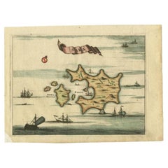
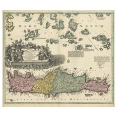
Antique Map of the Islands of Schiatti and Scopoli, Greece, 1687
$163.06
$203.8220% Off
£123.52
£154.4020% Off
€140
€17520% Off
CA$225.89
CA$282.3720% Off
A$253.35
A$316.6920% Off
CHF 132.68
CHF 165.8520% Off
MX$3,078.50
MX$3,848.1320% Off
NOK 1,684.79
NOK 2,105.9820% Off
SEK 1,597.30
SEK 1,996.6220% Off
DKK 1,065.93
DKK 1,332.4120% Off
About the Item
Antique map titled 'Schiatti - Scopoli.' This original antique map shows the islands Schiatti and Scopoli in Greece. Source unknown, to be determined.
Artists and Engravers: Made by 'Olfert Dapper' after an anonymous artist. Olfert Dapper (c. 1635 - 1689) was a Dutch physician and writer. He wrote books about history and geography, although he never travelled outside Holland. Until today, his book Description of Africa (1668) is a key text for Africanists.
Condition: Good, given age. Light vertical crease. General age-related toning and/or occasional minor defects from handling. Please study image carefully.
Date: 1687
Overall size: 20 x 15.5 cm.
Image size: 16.8 x 12.5 cm.
We sell original antique maps to collectors, historians, educators and interior decorators all over the world. Our collection includes a wide range of authentic antique maps from the 16th to the 20th centuries. Buying and collecting antique maps is a tradition that goes back hundreds of years. Antique maps have proved a richly rewarding investment over the past decade, thanks to a growing appreciation of their unique historical appeal. Today the decorative qualities of antique maps are widely recognized by interior designers who appreciate their beauty and design flexibility. Depending on the individual map, presentation, and context, a rare or antique map can be modern, traditional, abstract, figurative, serious or whimsical. We offer a wide range of authentic antique maps for any budget.
- Dimensions:Height: 6.11 in (15.5 cm)Width: 7.88 in (20 cm)Depth: 0 in (0.01 mm)
- Materials and Techniques:
- Period:
- Date of Manufacture:1687
- Condition:Condition: Good, given age. Light vertical crease. General age-related toning and/or occasional minor defects from handling. Please study image carefully.
- Seller Location:Langweer, NL
- Reference Number:Seller: PCT-616241stDibs: LU3054327826822
About the Seller
5.0
Recognized Seller
These prestigious sellers are industry leaders and represent the highest echelon for item quality and design.
Platinum Seller
Premium sellers with a 4.7+ rating and 24-hour response times
Established in 2009
1stDibs seller since 2017
2,517 sales on 1stDibs
Typical response time: <1 hour
- ShippingRetrieving quote...Shipping from: Langweer, Netherlands
- Return Policy
Authenticity Guarantee
In the unlikely event there’s an issue with an item’s authenticity, contact us within 1 year for a full refund. DetailsMoney-Back Guarantee
If your item is not as described, is damaged in transit, or does not arrive, contact us within 7 days for a full refund. Details24-Hour Cancellation
You have a 24-hour grace period in which to reconsider your purchase, with no questions asked.Vetted Professional Sellers
Our world-class sellers must adhere to strict standards for service and quality, maintaining the integrity of our listings.Price-Match Guarantee
If you find that a seller listed the same item for a lower price elsewhere, we’ll match it.Trusted Global Delivery
Our best-in-class carrier network provides specialized shipping options worldwide, including custom delivery.More From This Seller
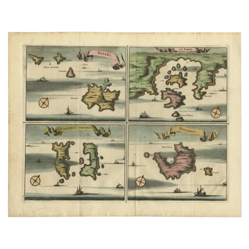
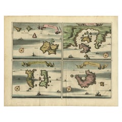
View AllAntique Map of Nisari, Le Simie, Carchi Elimoia and Piscopia, Greece, 1687
Located in Langweer, NL
Antique map titled 'Carchi Elimoia, Nisari, Le Simie, Piscopia.' Sheet with four maps on one page showing Nisyros, Simi and other islands, Greece. Source unknown, to be determined. A...
Category
Antique 17th Century Maps
Materials
Paper
$391 Sale Price
20% Off
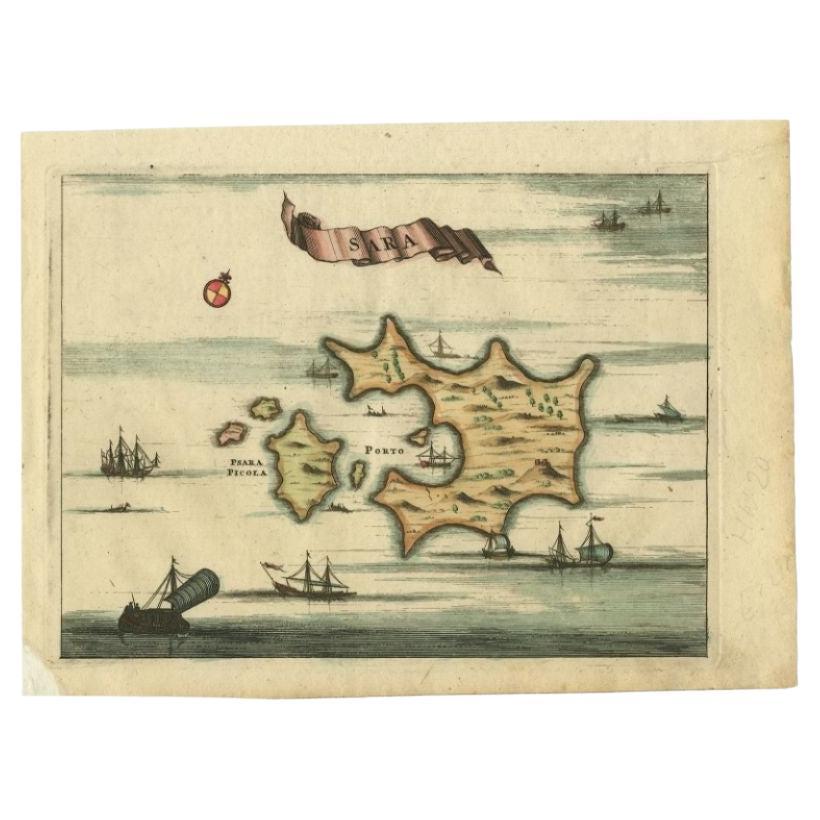
Antique Map of the Island of Psara by Dapper, 1688
Located in Langweer, NL
Antique map titled 'Sara.' Map of Psara ( Psyra or Ipsera) Island (North East Aegean Islands), Greece. This map originates from 'Nauwkeurige Beschrijving der eilanden in de Archipel ...
Category
Antique 17th Century Maps
Materials
Paper
$139 Sale Price
20% Off
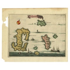
Antique Map of the Island of Kyra Panagia by Dapper, 1688
Located in Langweer, NL
Antique map titled 'Pelagnisi.' Map of the island of Kyra Panagia, Pelagnisi (Pelagos), Greece. This map originates from 'Nauwkeurige Beschrijving der eilanden in de Archipel der Mid...
Category
Antique 17th Century Maps
Materials
Paper
$139 Sale Price
20% Off
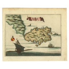
Antique Map of the Island of Tinos by Dapper, 1687
Located in Langweer, NL
Antique map titled 'Tino.' This original antique map shows the island of Tinos, Greece. Source unknown, to be determined.
Artists and Engravers: Made by 'Olfert Dapper' after an a...
Category
Antique 17th Century Maps
Materials
Paper
$163 Sale Price
20% Off
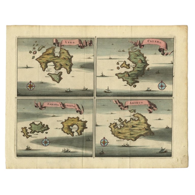
Original Antique Map of Leros and Kalimnos, and other islands, Greece, 1687
Located in Langweer, NL
Antique map titled 'Lero, Calamo, Zanara e Levita, Amorgo.'
heet with four maps on one page showing the islands Leros, Kalimnos, and other islands, Greece. Source unknown, to be de...
Category
Antique 17th Century Maps
Materials
Paper

$512 Sale Price
20% Off
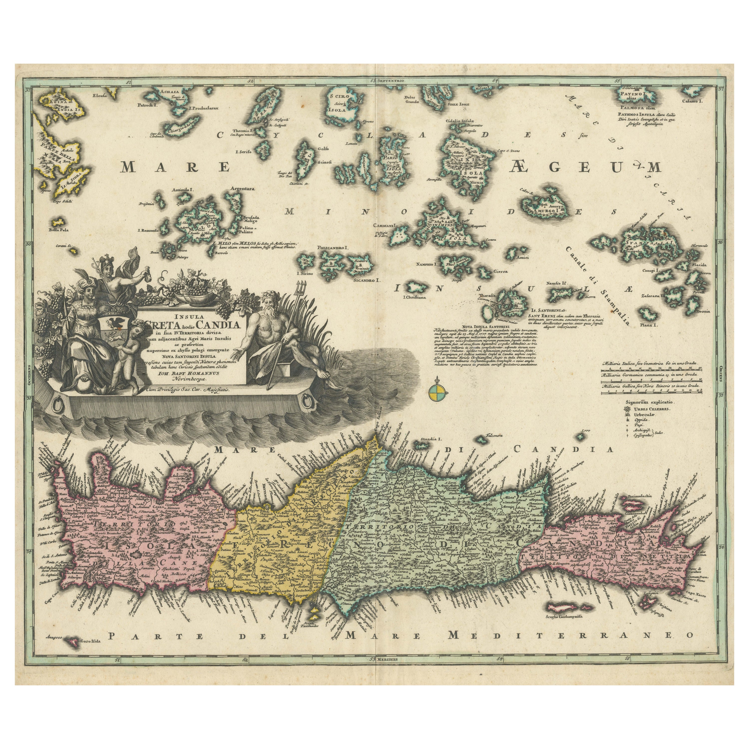
Crete Map 1749 – Homann Heirs Engraving of Candia with Aegean Islands
Located in Langweer, NL
Crete Map 1749 – Homann Heirs Engraving of Candia with Aegean Islands
This fine 1749 map titled 'Insula Creta hodie Candia' presents an 18th-century cartographic portrait of the isl...
Category
Antique 1740s German Maps
Materials
Paper
You May Also Like
Antique Map - Mar Di Athiopia - Etching by Johannes Janssonius - 1650s
By Johannes Janssonius
Located in Roma, IT
Antique Map - Mar Di Athiopia is an antique map realized in 1650 by Johannes Janssonius (1588-1664).
The Map is Hand-colored etching, with coeval watercolorang.
Good conditions wit...
Category
1650s Modern Figurative Prints
Materials
Etching

Ancient Map - Zeilan - Etching by Johannes Janssonius - 1650s
By Johannes Janssonius
Located in Roma, IT
Ancient Map - Zeilan is an ancient map realized in 1650 by Johannes Janssonius (1588-1664).
The Map is Hand-colored etching, with coeval watercoloring.
...
Category
1650s Modern Figurative Prints
Materials
Etching

Antique Map - Gallia - Etching by Johannes Janssonius - 1650s
By Johannes Janssonius
Located in Roma, IT
Antique Map - Gallia is an antique map realized in 1650 by Johannes Janssonius (1588-1664).
The Map is Hand-colored etching, with coeval watercoloring.
Good conditions with slight ...
Category
1650s Modern Figurative Prints
Materials
Etching

Antique Map - Mare Pacificum - Etching by Johannes Janssonius - 1650s
By Johannes Janssonius
Located in Roma, IT
Mare Pacificum is an antique map realized in 1650 by Johannes Janssonius (1588-1664).
The Map is Hand-colored etching, with coeval watercolorang.
Good conditions with slight foxing...
Category
1650s Modern Figurative Prints
Materials
Etching

Southern Greece: A Large 17th C. Hand-colored Map by Sanson and Jaillot
By Nicolas Sanson
Located in Alamo, CA
This large original hand-colored copperplate engraved map of southern Greece and the Pelopponese Peninsula entitled "La Moree Et Les Isles De Zante, Cefalonie, Ste. Marie, Cerigo & C...
Category
Antique 1690s French Maps
Materials
Paper

Map of Greece - Original Etching by Antonio Zatta - 18th Century
Located in Roma, IT
This Map of Greece is an etching realized by Antonio Zatta, Cartographer, publisher and typographer.
The state of preservation of the artwork is good except for the worn paper and t...
Category
1780s Figurative Prints
Materials
Etching

More Ways To Browse
Greek Key Handle
Antique Furniture Kingston
Antique Louisiana Map
Armenia Map
L Tardieu
Chinese Wall Pocket
18th Century Nautical Engraving
Antique Map Burgundy
Antique Map By Coronelli
Antique Maps Singapore
Constantinople Map
Iraq Map
Mughal Map
Map Of Palestine
Victorian Portico
Antique Furniture Dundee
Antique Map Iceland
Antique Maps Of Malta