Items Similar to Antique Map of the Kingdom of Hungary and Transylvania, circa 1780


Video Loading
Want more images or videos?
Request additional images or videos from the seller
1 of 11
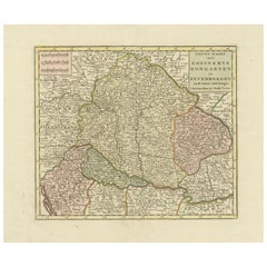
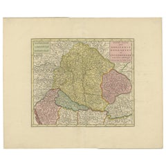
Antique Map of the Kingdom of Hungary and Transylvania, circa 1780
$545.21
£405.90
€460
CA$751.21
A$836.48
CHF 442.35
MX$10,179.41
NOK 5,575.90
SEK 5,253.32
DKK 3,501.76
About the Item
Antique Map of the Kingdom of Hungary and Surrounding Regions by S. Robert, circa 1780
This beautifully engraved map titled Royaume de Hongrie, Principauté de Transilvanie, Esclavonie, Croatie, et partie de la Principauté de Valaquie, de la Bosnie, de la Servie et de la Bulgarie was created by the French geographer S. Robert around 1780. The map offers a comprehensive view of the Kingdom of Hungary at a time when it was a crucial territory within the Habsburg Monarchy. It includes not only Hungary but also Transylvania, Slavonia, Croatia, and parts of modern-day Romania, Serbia, Bosnia, and Bulgaria.
The map’s elaborate title cartouche, found in the upper left corner, features classical motifs such as foliage, armor, and banners, emphasizing the political and military importance of the region. It is signed "Par le Sr. Robert, Géographe," clearly identifying the mapmaker. S. Robert was active in Paris in the latter part of the 18th century and is known for producing detailed regional maps during a time of significant geopolitical change in Europe.
The geography is rendered with fine detail, showing cities, towns, rivers, and mountain ranges, all engraved with precision. Political boundaries are hand-colored in yellow, green, and red to distinguish various regions and principalities. The Danube River, a defining feature of Central Europe, flows prominently through the center of the map. Important cities such as Buda, Pest, Pressburg (Bratislava), Temeswar, and Hermannstadt (Sibiu) are clearly marked, along with the major road networks and fortifications of the time.
This map offers valuable insight into the territorial complexity of southeastern Europe before the Napoleonic Wars and long before the unification of many of its modern nations. It would have served scholars, diplomats, and military strategists during an era of imperial expansion and frontier management.
Condition:
The map is in good condition for its age. Original fold lines as issued. The paper shows mild age toning, with a few minor creases and faint spots.. The engraved details remain sharp, and the hand-colored borders are still vibrant and clear. There is some minor edge wear, but nothing affecting the main printed area.
Framing suggestion:
This historic map would be beautifully complemented by a classic dark wood or mahogany frame, ideally with a soft ivory or light beige archival mat to highlight the intricate detail. UV-resistant glass is recommended to protect the print from fading over time. A vertical frame layout suits its format and makes it ideal for display in a study, hallway, or office.
- Dimensions:Height: 20.56 in (52.2 cm)Width: 25.6 in (65 cm)Depth: 0.01 in (0.2 mm)
- Materials and Techniques:Paper,Engraved
- Place of Origin:
- Period:
- Date of Manufacture:circa 1780
- Condition:The map is in good condition for its age. Original fold lines as issued. The paper shows mild age toning, with a few minor creases and faint spots.. The engraved details remain sharp, and the hand-colored borders are still vibrant and clear.
- Seller Location:Langweer, NL
- Reference Number:Seller: BG-13769-431stDibs: LU3054345616832
About the Seller
5.0
Recognized Seller
These prestigious sellers are industry leaders and represent the highest echelon for item quality and design.
Platinum Seller
Premium sellers with a 4.7+ rating and 24-hour response times
Established in 2009
1stDibs seller since 2017
2,567 sales on 1stDibs
Typical response time: <1 hour
- ShippingRetrieving quote...Shipping from: Langweer, Netherlands
- Return Policy
Authenticity Guarantee
In the unlikely event there’s an issue with an item’s authenticity, contact us within 1 year for a full refund. DetailsMoney-Back Guarantee
If your item is not as described, is damaged in transit, or does not arrive, contact us within 7 days for a full refund. Details24-Hour Cancellation
You have a 24-hour grace period in which to reconsider your purchase, with no questions asked.Vetted Professional Sellers
Our world-class sellers must adhere to strict standards for service and quality, maintaining the integrity of our listings.Price-Match Guarantee
If you find that a seller listed the same item for a lower price elsewhere, we’ll match it.Trusted Global Delivery
Our best-in-class carrier network provides specialized shipping options worldwide, including custom delivery.More From This Seller
View AllAntique Map of the Kingdom of Hungary by Keizer & de Lat, 1788
Located in Langweer, NL
Antique map titled 't Koninkryk Hongarien (..)'. Uncommon original antique map of the Kingdom of Hungary. This map originates from 'Nieuwe Natuur- Geschied- en Handelkundige Zak- en ...
Category
Antique Late 18th Century Maps
Materials
Paper

$331 Sale Price
20% Off
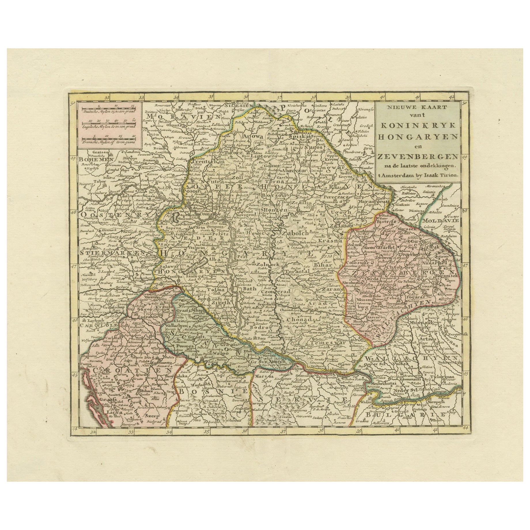
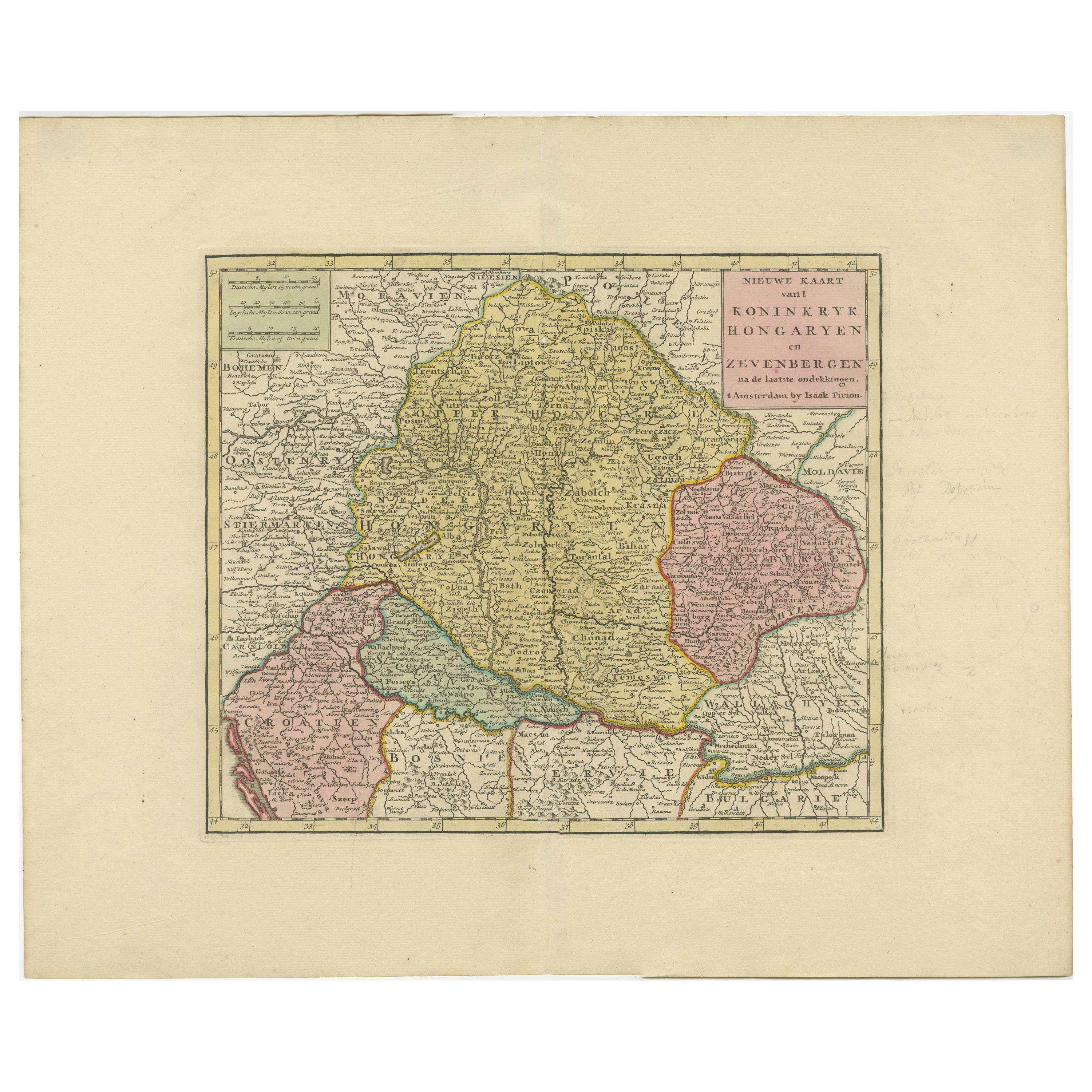
Detailed Antique Map of Hungary and Transylvania by Tirion, 1753
Located in Langweer, NL
Title: Nieuwe Kaart van’t Koninkryk Hongaryen en Zevenbergen by Isaak Tirion, 1753 – Antique Map of Hungary and Transylvania
Description: This is an antique 1753 map titled *Nieuwe Kaart van’t Koninkryk Hongaryen en Zevenbergen*, created by the notable Dutch cartographer and publisher Isaak Tirion. The map showcases the Kingdom of Hungary and the region of Transylvania (referred to as "Zevenbergen") as they appeared in the mid-18th century. Tirion’s maps are well-known for their clarity, precision, and attention to geographic detail, making them highly sought after by collectors of antique maps.
This map provides a detailed view of Hungary and Transylvania, including borders, towns, cities, rivers, and mountain ranges. It was created using the latest discoveries and updates of the time and reflects the political landscape of the region, which was part of the Habsburg Empire during a period of territorial changes and consolidations. The map’s borders are highlighted with color to distinguish different regions, and significant cities such as Buda, Pest, and Debrecen are clearly labeled.
Isaak Tirion was one of the most prominent Dutch publishers of the 18th century, particularly known for his *Nieuwe en Beknopte Hand-Atlas* (New and Concise Hand Atlas) series, which included a wide range of maps of Europe and beyond. His works were appreciated for their cartographic accuracy and artistic quality.
This map is a valuable piece for collectors interested in 18th-century European maps, particularly those that highlight Central Europe, Hungary, Transylvania, and the Habsburg Empire. It is a fine example of the craftsmanship of Isaak Tirion and offers insight into the historical geography of the region.
Condition: Excellent for its age, with finely preserved hand-coloring and wide margins. Slight edge wear typical of maps from this period.
Effective keywords that may help attract collectors or enthusiasts interested in historical maps of Hungary, Transylvania, and Central Europe:
- Antique map of Hungary
- Historical map of Transylvania
- 18th-century map of Central Europe
- Habsburg Empire map
- Isaak Tirion map
- Nieuwe Kaart van’t Koninkryk Hongaryen en Zevenbergen
- Kingdom of Hungary map...
Category
Antique 1750s Maps
Materials
Paper
$572 Sale Price
30% Off
Antique Map of Hungary and Transylvania by Isaak Tirion, Amsterdam c.1740
Located in Langweer, NL
Poland Map 1740s – Nieuwe Kaart van het Koninryk Poolen by Isaak Tirion
This finely engraved and attractively hand-colored map of the Kingdom of Poland was published by Isaak Tirion...
Category
Antique Mid-18th Century Dutch Maps
Materials
Paper
Antique Map of Hungary Incl Surroundings like Croatia, Bosnia, Servia, 1730
Located in Langweer, NL
Antique map titled 'Nieuwe Kaart van t Koninkryk Hongaryen en Zevenbergen na de laatste ontdekkingen'.
This map depicts Hungary including surroundings like Croatia, Bosnia, Servia,...
Category
Antique 18th Century Maps
Materials
Paper

$521 Sale Price
20% Off
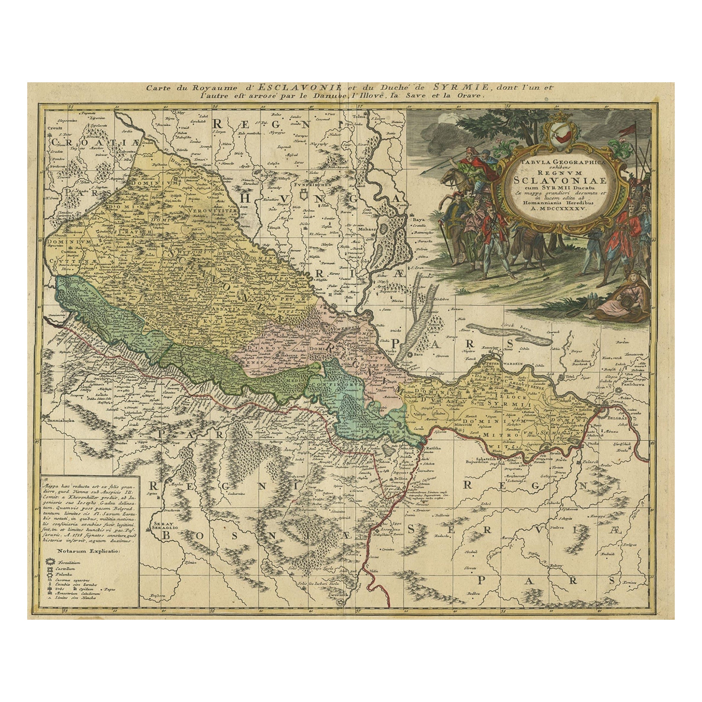
Detailed Antique Map of Slavonia, the Region in Eastern Croatia, ca.1745
Located in Langweer, NL
Antique map titled 'Tabula Geographica exhibens Regnum Sclavoniae.'
Detailed map of Slavonia, the region in eastern Croatia. Map is dated shortly after the Peace of Belgrade sign...
Category
Antique 1740s Maps
Materials
Paper
$616 Sale Price
20% Off
Decorative Original Antique Map of Southern Germany, c.1730
Located in Langweer, NL
"Antique map titled 'The South West Part of Germany. Containing ye Dominions of the Archbishops and Electors of Mentz Y Treves, and of ye Elec. Palatine of ye Rhine; with Franconia, ...
Category
Antique 18th Century Maps
Materials
Paper

You May Also Like
Original Antique Map of Hungary, Arrowsmith, 1820
Located in St Annes, Lancashire
Great map of Hungary
Drawn under the direction of Arrowsmith.
Copper-plate engraving.
Published by Longman, Hurst, Rees, Orme and Brown, 1820
Unframed.
Category
Antique 1820s English Maps
Materials
Paper

Austria-Hungary, Western Part. Century Atlas antique vintage map
Located in Melbourne, Victoria
'The Century Atlas. Austria-Hungary, Western Part'
Original antique map, 1903.
Central fold as issued. Map name and number printed on the reverse corners.
Sheet 40cm by 29.5cm.
Category
Early 20th Century Victorian More Prints
Materials
Lithograph

Map of the War between Hungary and Prussia - Etching - 19th Century
Located in Roma, IT
Map of the War between Hungary and Prussia is an etching realized during the 19th century.
Good condition.
Category
Early 19th Century Modern Figurative Prints
Materials
Etching
Map of the War between Hungary and Prussia - Etching - 19th Century
Located in Roma, IT
Map of the War between Hungary and Prussia is an etching realized during the 19th century.
Good condition.
Category
Early 19th Century Modern Figurative Prints
Materials
Etching

Map of the War -Vesfaglia and Lower Saxony - Etching - 19th Century
Located in Roma, IT
Map of the War -Vestaglia and Lower Saxony is an etching realized during the 19th century.
Good condition.
Category
Early 19th Century Modern Figurative Prints
Materials
Etching

17th Century Nicolas Visscher Map of Southeastern Europe
Located in Hamilton, Ontario
A beautiful, highly detailed map of southeastern Europe by Nicolas Visscher. Includes regions of Northern Italy (showing the cities Bologna, Padua, and Venice), Bohemia, Austria (sho...
Category
Antique 17th Century Dutch Maps
Materials
Paper

$1,350 Sale Price
38% Off
More Ways To Browse
Hungarian Wood Furniture
Antique Ivory Collectables
Antique Wood Hungarian
Used Road Signs
Foldable Military
Scholar Antiques
Romania Glass
Imperial Mahogany
Styles Of Antique Desks
Black And White Coffee Table
Curved Velvet Couch
Velvet Curved Sofa
Wood Round Coffee Tables
Antique Paper Flowers
Oak Brutalist
Used College Furniture
Wood Minimalist Chair
2002 Lamp