Items Similar to Antique Map of Mecklenburg-Vorpommern in Germany by J.B. Homann, c.1720


Want more images or videos?
Request additional images or videos from the seller
1 of 6
Antique Map of Mecklenburg-Vorpommern in Germany by J.B. Homann, c.1720
$514.83
$643.5420% Off
£381.27
£476.5920% Off
€432
€54020% Off
CA$709.29
CA$886.6120% Off
A$788.60
A$985.7620% Off
CHF 415.25
CHF 519.0620% Off
MX$9,568.15
MX$11,960.1820% Off
NOK 5,257.24
NOK 6,571.5620% Off
SEK 4,914.24
SEK 6,142.8020% Off
DKK 3,288.31
DKK 4,110.3920% Off
About the Item
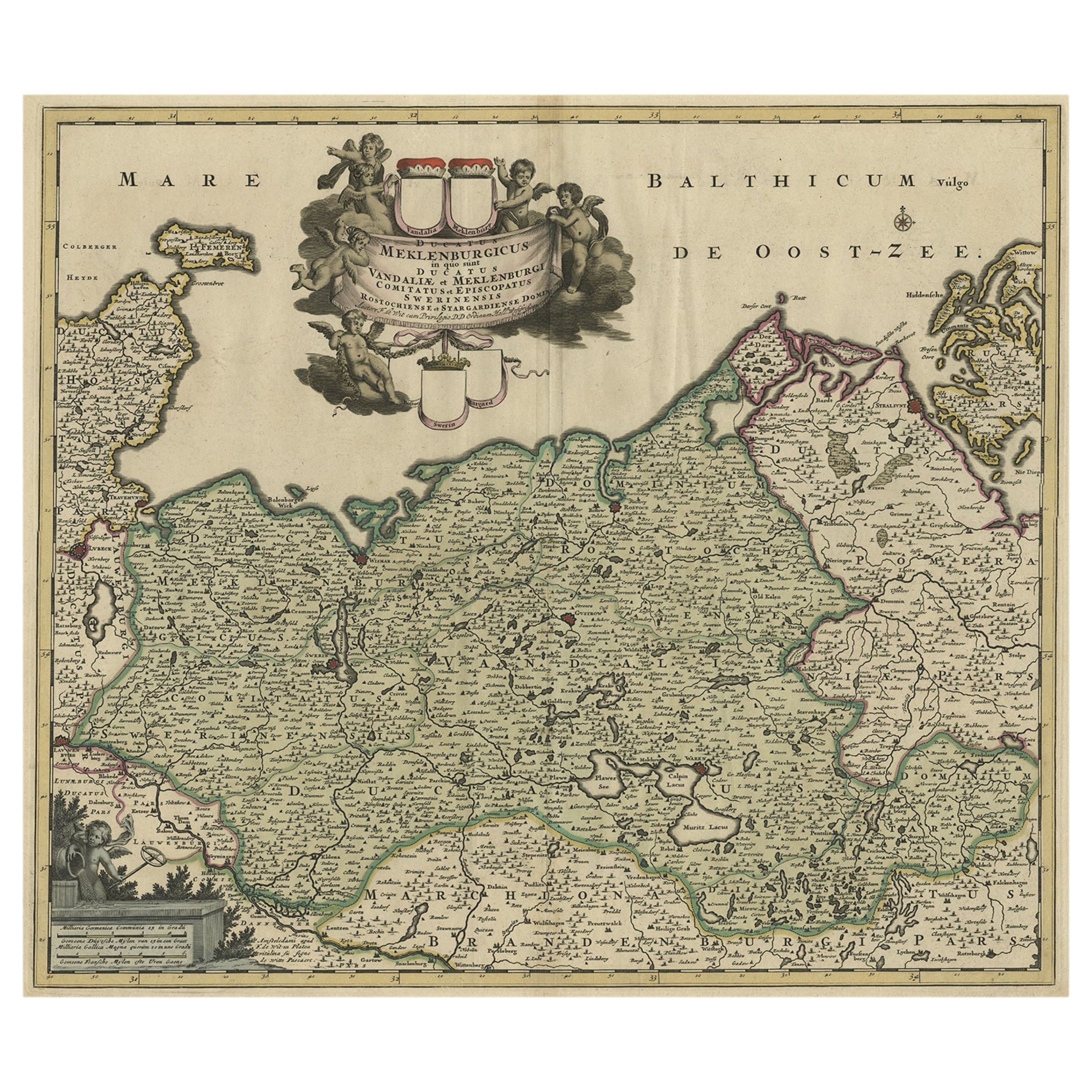
Antique Map of Mecklenburg-Vorpommern by J.B. Homann, c.1720
Old colored antique map of Mecklenburg-Vorpommern by Johann Baptist Homann. This stunning map, titled "Ducatus Meklenburgici Tabula Generalis Continens Duc. Vandaliae et Meklenburg Comitatum et Episcopatum Swerinensem Rostochiense et Stargardiense Dominium," was published in Nuremberg around 1720. It offers a detailed depiction of the Baltic Sea coastline, stretching from Holstein, including Fehmarn, Travemünde, and Lübeck, to Wismar, Rostock, and the island of Rügen. Further south, the map highlights the Mecklenburg Lake District, prominently featuring the Müritz.
What makes this map particularly fascinating is its meticulous detail combined with artistic embellishment, typical of Homann's work. The top features a decorative cartouche adorned with cherubs, coats of arms, and other allegorical elements, adding an artistic and historical charm.
Johann Baptist Homann (1664–1724), a renowned German cartographer, was famous for his detailed and aesthetically rich maps, often blending scientific accuracy with artistic beauty. As the founder of the Homann Heirs map publishing firm, his works were instrumental in advancing cartographic knowledge and became highly sought after during the 18th century. His maps are celebrated for their precision, colorization, and decorative appeal, securing his legacy as one of the most influential mapmakers of his time.
The Latin title "Ducatus Meklenburgici Tabula Generalis Continens Duc. Vandaliae et Meklenburg Comitatum et Episcopatum Swerinensem Rostochiense et Stargardiense Dominium" translates to:
"General Map of the Duchy of Mecklenburg, including the Duchy of Vandalia and Mecklenburg, the County and Bishoprics of Schwerin, Rostock, and the Dominion of Stargard."
Here is the breakdown of the translation:
- Ducatus Meklenburgici: Duchy of Mecklenburg
- Tabula Generalis: General Map
- Continens: Containing or Including
- Duc. Vandaliae et Meklenburg: Duchy of Vandalia and Mecklenburg (Vandalia refers to a historical designation linked to Slavic tribes in this area)
- Comitatum: County
- Episcopatum Swerinensem Rostochiense et Stargardiense Dominium: Bishoprics of Schwerin, Rostock, and the Dominion of Stargard
This phrasing captures the geographic and administrative significance of the areas depicted in the map. It is located in the northeastern part of Germany, along the Baltic Sea coast. The map also includes parts of nearby regions like Holstein, Lübeck, and Rügen, all of which are historically tied to Germany.
The ornate cartouche is surrounded by cherubs, symbolic elements, and heraldic motifs, which add to the map’s artistic and historical significance. Such decorative cartouches were a hallmark of Johann Baptist Homann’s maps, serving as both a functional and aesthetic feature.
- Dimensions:Height: 19.49 in (49.5 cm)Width: 23.04 in (58.5 cm)Depth: 0.01 in (0.2 mm)
- Materials and Techniques:Paper,Engraved
- Period:1720-1729
- Date of Manufacture:circa 1720
- Condition:Condition: good, given age. General age-related toning and/or occasional minor defects from handling. Short margins and vertical fold in middle as issued. On the reverse a few remains of tape. Please study scan carefully.
- Seller Location:Langweer, NL
- Reference Number:Seller: BG-13892-11stDibs: LU3054342438452
About the Seller
5.0
Recognized Seller
These prestigious sellers are industry leaders and represent the highest echelon for item quality and design.
Platinum Seller
Premium sellers with a 4.7+ rating and 24-hour response times
Established in 2009
1stDibs seller since 2017
2,569 sales on 1stDibs
Typical response time: <1 hour
- ShippingRetrieving quote...Shipping from: Langweer, Netherlands
- Return Policy
Authenticity Guarantee
In the unlikely event there’s an issue with an item’s authenticity, contact us within 1 year for a full refund. DetailsMoney-Back Guarantee
If your item is not as described, is damaged in transit, or does not arrive, contact us within 7 days for a full refund. Details24-Hour Cancellation
You have a 24-hour grace period in which to reconsider your purchase, with no questions asked.Vetted Professional Sellers
Our world-class sellers must adhere to strict standards for service and quality, maintaining the integrity of our listings.Price-Match Guarantee
If you find that a seller listed the same item for a lower price elsewhere, we’ll match it.Trusted Global Delivery
Our best-in-class carrier network provides specialized shipping options worldwide, including custom delivery.More From This Seller
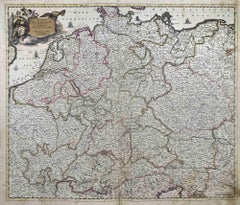
View AllA Handsome & Detailed Map of the Duchy of Mecklenburg & Pomerania, Germany, 1680
Located in Langweer, NL
Antique map titled 'Ducatus Meklenburgicus in quo sunt Ducatus Vandaliae et Meklenburgi Ducatus et Comitatus Swerinensis.'
A handsome and detailed map of the Duchy of Mecklenburg...
Category
Antique 1680s Maps
Materials
Paper
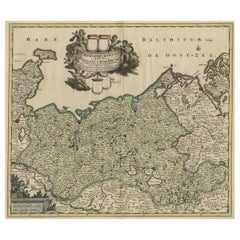
$705 Sale Price
20% Off
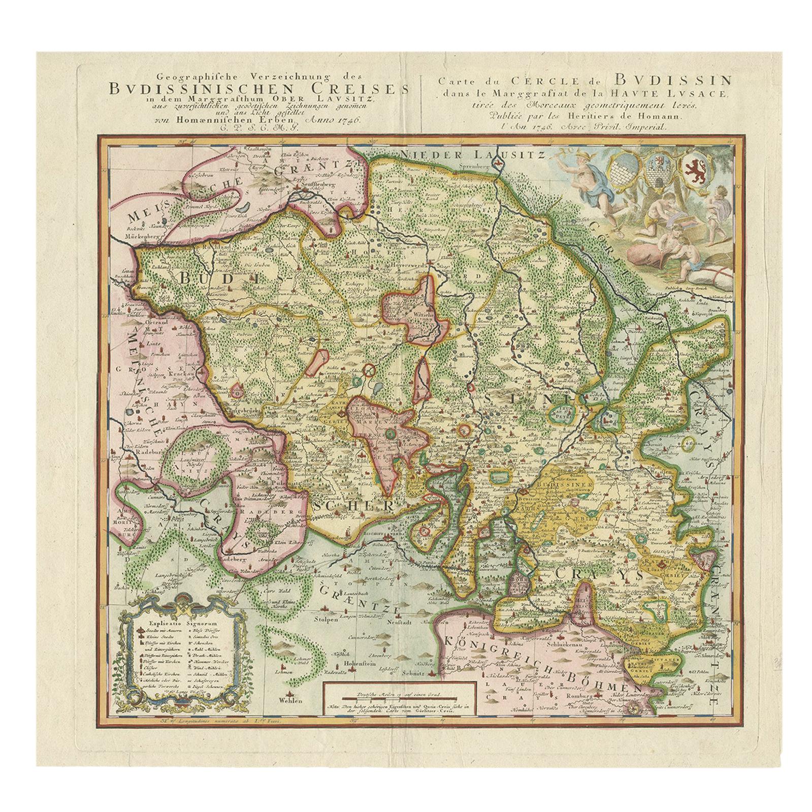
Antique Map of Oberlausitz by Homann Erben, '1746'
Located in Langweer, NL
Antique map titled 'Geographische Verzeichnung des Budissinischen Creises (..) - Carte du Cercle de Budissin (..)'. Copper engraved map of Oberlausitz, a historical region of Saxony ...
Category
Antique Mid-18th Century Maps
Materials
Paper
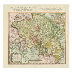
$429 Sale Price
20% Off
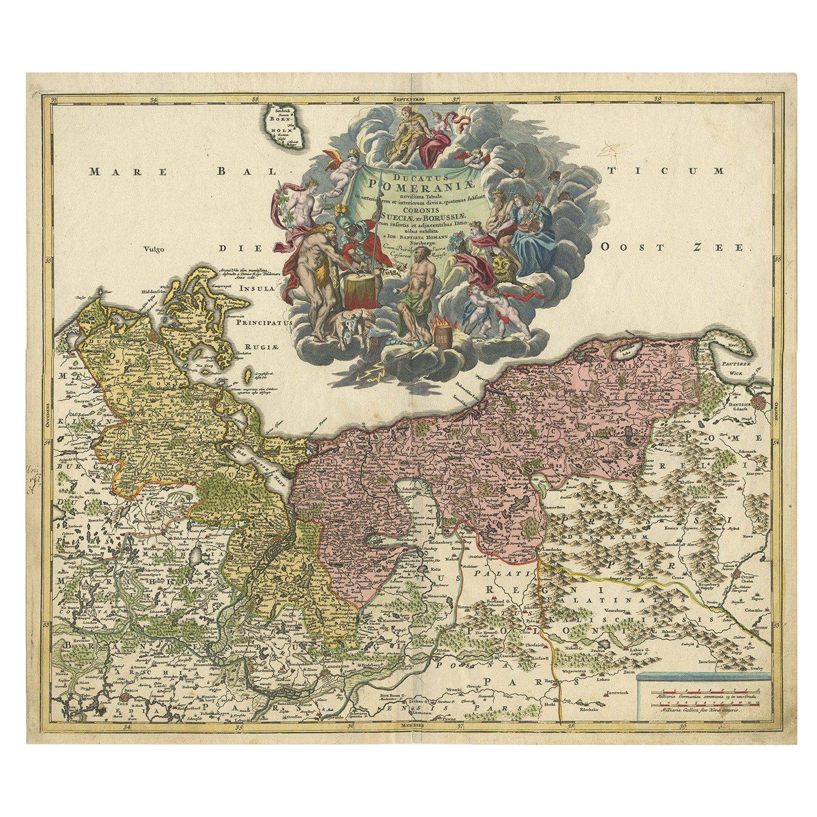
Regional Antique Map of the Baltic, Extending from Stralsund to Dantzig, ca.1720
Located in Langweer, NL
Antique map titled 'Ducatus Pomeraniae (..)'. Regional map of the Baltic, extending from Stralsund and Rugia in the west to Dantzig and Culman on the Vistula in the east. Large carto...
Category
Antique 1720s Maps
Materials
Paper
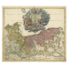
$848 Sale Price
20% Off
Antique Map of Southern Germany by F. de Wit, circa 1680
Located in Langweer, NL
This antique map depicts a portion of southern Germany that included the historic regions of Bavaria, the Palatinate, Prussia-Brandenburg, the Rhineland and Saxony. Regensberg, Freis...
Category
Antique Late 17th Century Maps
Materials
Paper

$662 Sale Price
20% Off
Antique Map of Germany by T. Kitchin, circa 1770
Located in Langweer, NL
Antique map titled 'An Accurate Map of Germany (..) '. Drawn from the best Authorities by T.Kitchin Geogr." Rare edition, drawn and etched by Thomas Kitchin, published, circa 1770.
Category
Antique Mid-18th Century Maps
Materials
Paper

$228 Sale Price
20% Off
Antique Map of Germany from a 17th Century Pocket Atlas, 1685
Located in Langweer, NL
Antique map titled 'Nova Totius Germaniae descriptio.' Miniature map of Germany, from the pocket atlas 'Introductionis in Universam Geographiam tam Veterem...
Category
Antique 17th Century Maps
Materials
Paper
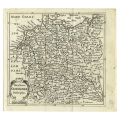
$119 Sale Price
20% Off
You May Also Like
A Hand Colored 17th Century Janssonius Map of Prussia: Poland, N. Germany, etc.
By Johannes Janssonius
Located in Alamo, CA
An attractive hand-colored copperplate engraved 17th century map of Prussia entitled "Prussia Accurate Descripta a Gasparo Henneberg Erlichensi", published in Amsterdam by Joannes Janssonius in 1664. This very detailed map from the golden age of Dutch cartography includes present-day Poland, Latvia, Lithuania, Estonia and portions of Germany. This highly detailed map is embellished by three ornate pink, red, mint green and gold...
Category
Mid-17th Century Old Masters Landscape Prints
Materials
Engraving

West Germany: Original Hand Colored 17th Century Map by Johannes Janssonius
By Johannes Janssonius
Located in Alamo, CA
An original hand colored copperplate engraved map entitled in Latin "Archiepiscopatus Maghdeburgensis et Anhaltinus Ducatus cum terris adjacentibus", published in Amsterdam in 1640 i...
Category
Mid-17th Century Old Masters More Prints
Materials
Engraving

Accuratissima Germaniae Tabula - Etching by Frederick de Wit - 1680ca
By Frederick de Wit
Located in Roma, IT
This double-page etching with contemporary coloring, entitled Accuratissima Germaniae Tabula [...], was realized by the cartographer Frederick de Wit for the famous Atlas published i...
Category
1680s Modern Figurative Prints
Materials
Etching
Map of the War -Vesfaglia and Lower Saxony - Etching - 19th Century
Located in Roma, IT
Map of the War -Vestaglia and Lower Saxony is an etching realized during the 19th century.
Good condition.
Category
Early 19th Century Modern Figurative Prints
Materials
Etching

German Empire, Northern Part. Century Atlas antique vintage map
Located in Melbourne, Victoria
'The Century Atlas. German Empire, Northern Part.'
Original antique map, 1903.
Central fold as issued. Map name and number printed on the reverse corne...
Category
Early 20th Century Victorian More Prints
Materials
Lithograph

Map of Denmark, 1724
Located in Houston, TX
Extraordinary copper engraved map of Denmark by cartographer Christoph Weigel from 1724. Shows counties, rivers and towns. Ornate title cartouche. Original hand-color. Over 250 years old.
Original antique map displayed...
Category
17th Century Other Art Style More Prints
Materials
Paper, Ink, Watercolor

More Ways To Browse
Elios Chair
Plata Lappas
Red Retro Dining Set
Antique Bouquet
Antique Silver Glasses Case
Carlo Scarpa 1934 Chairs
Christofle Marly
1900 Antique Chairs
Glass Table Italian Round
Mid Century Colonial
Alvar Aalto Poster
Geometric Metal Table
Post Modern High Chairs
United Nations
Vintage Vine Rug
Cancel An Order
Antique Framing Square
Silver Metal Chair