Items Similar to Antique Map of the Netherlands by N. Visscher, 1684

Want more images or videos?
Request additional images or videos from the seller
1 of 9
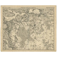
Antique Map of the Netherlands by N. Visscher, 1684
$1,053.71
$1,317.1420% Off
£778.92
£973.6520% Off
€880
€1,10020% Off
CA$1,433.12
CA$1,791.4020% Off
A$1,605.80
A$2,007.2520% Off
CHF 835.88
CHF 1,044.8520% Off
MX$19,644.49
MX$24,555.6220% Off
NOK 10,609.95
NOK 13,262.4420% Off
SEK 10,020.97
SEK 12,526.2120% Off
DKK 6,700.77
DKK 8,375.9620% Off
Shipping
Retrieving quote...The 1stDibs Promise:
Authenticity Guarantee,
Money-Back Guarantee,
24-Hour Cancellation
About the Item
Antique map titled 'Comitatus Hollandiae Tabula Pluribus Locis Recens Emendata a Nicolao I. Visschero'. West to the top. Lower left inset of the Wadden Islands, Texel, Vlieland, Terschelling and part of Ameland. This map originates from 'N. Visscheri Germania Inferior sive XVII Provincicarum Geographicae', Amsterdam 1684.
- Dimensions:Height: 20.75 in (52.7 cm)Width: 24.81 in (63 cm)Depth: 0.02 in (0.5 mm)
- Materials and Techniques:Paper,Engraved
- Period:Late 17th Century
- Date of Manufacture:1684
- Condition:Wear consistent with age and use. Minor fading. Please study image carefully.
- Seller Location:Langweer, NL
- Reference Number:Seller: BG-091491stDibs: LU305439930871
About the Seller
5.0
Recognized Seller
These prestigious sellers are industry leaders and represent the highest echelon for item quality and design.
Platinum Seller
Premium sellers with a 4.7+ rating and 24-hour response times
Established in 2009
1stDibs seller since 2017
2,493 sales on 1stDibs
Typical response time: <1 hour
- ShippingRetrieving quote...Shipping from: Langweer, Netherlands
- Return Policy
Authenticity Guarantee
In the unlikely event there’s an issue with an item’s authenticity, contact us within 1 year for a full refund. DetailsMoney-Back Guarantee
If your item is not as described, is damaged in transit, or does not arrive, contact us within 7 days for a full refund. Details24-Hour Cancellation
You have a 24-hour grace period in which to reconsider your purchase, with no questions asked.Vetted Professional Sellers
Our world-class sellers must adhere to strict standards for service and quality, maintaining the integrity of our listings.Price-Match Guarantee
If you find that a seller listed the same item for a lower price elsewhere, we’ll match it.Trusted Global Delivery
Our best-in-class carrier network provides specialized shipping options worldwide, including custom delivery.More From This Seller
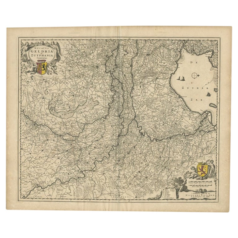
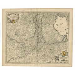
View AllAntique Map of the Dutch Province of Gelderland by Visscher, c.1670
Located in Langweer, NL
Antique map titled 'Ducatus Geldria et Zutphania Comitatus'. Map of the Duchy of Gelre (Gelderland) and the county of Zutphen, The Netherlands. Artists and Engravers: Made after the ...
Category
Antique 17th Century Maps
Materials
Paper
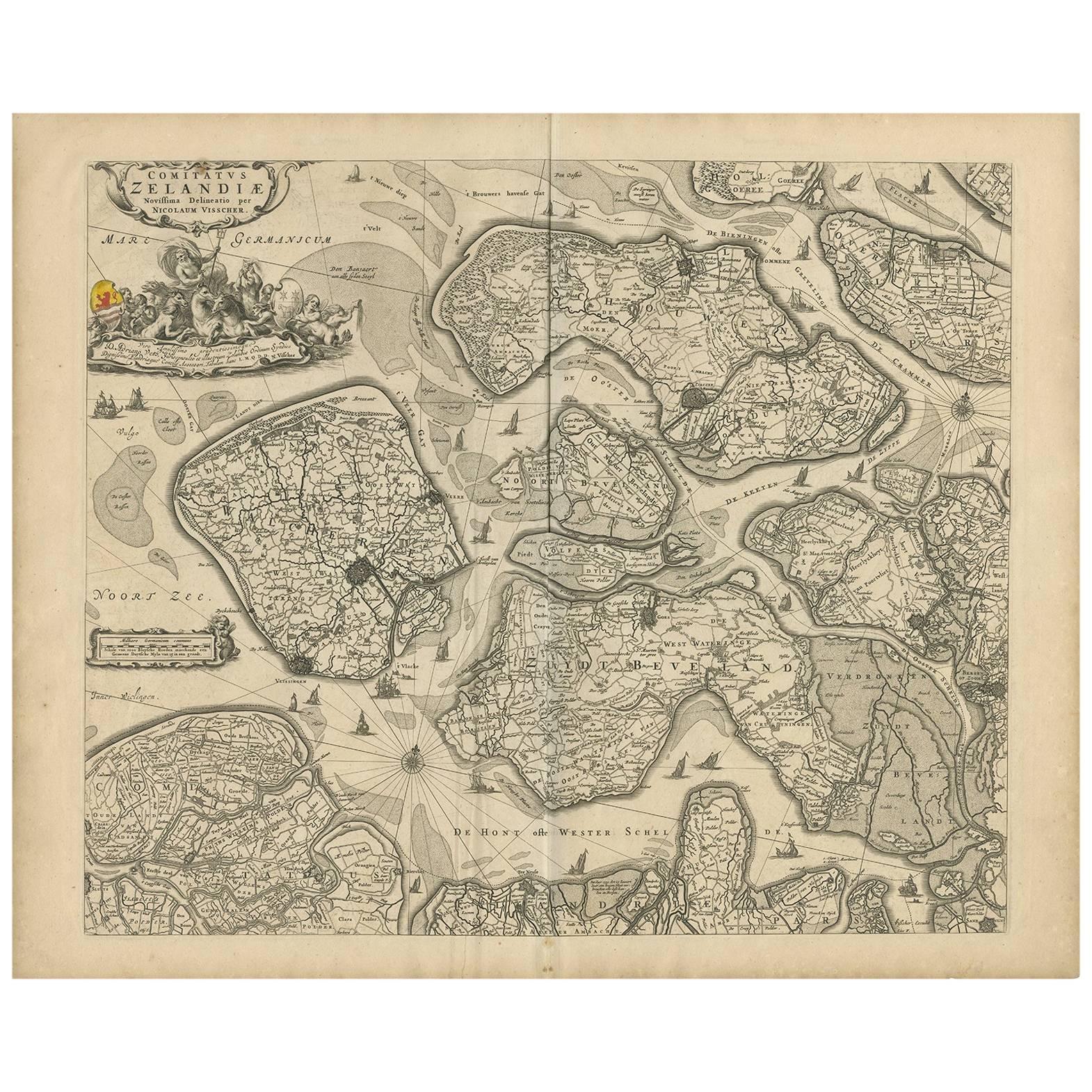
Antique Map of Zeeland 'The Netherlands' by N. Visscher, circa 1690
Located in Langweer, NL
Antique map titled 'Comitatus Zelandiae (..)'. Detailed chart of the province Zeeland, The Netherlands, with details shown pictorially. Published by N. Visscher.
Category
Antique Late 17th Century Maps
Materials
Paper
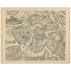
$632 Sale Price
20% Off
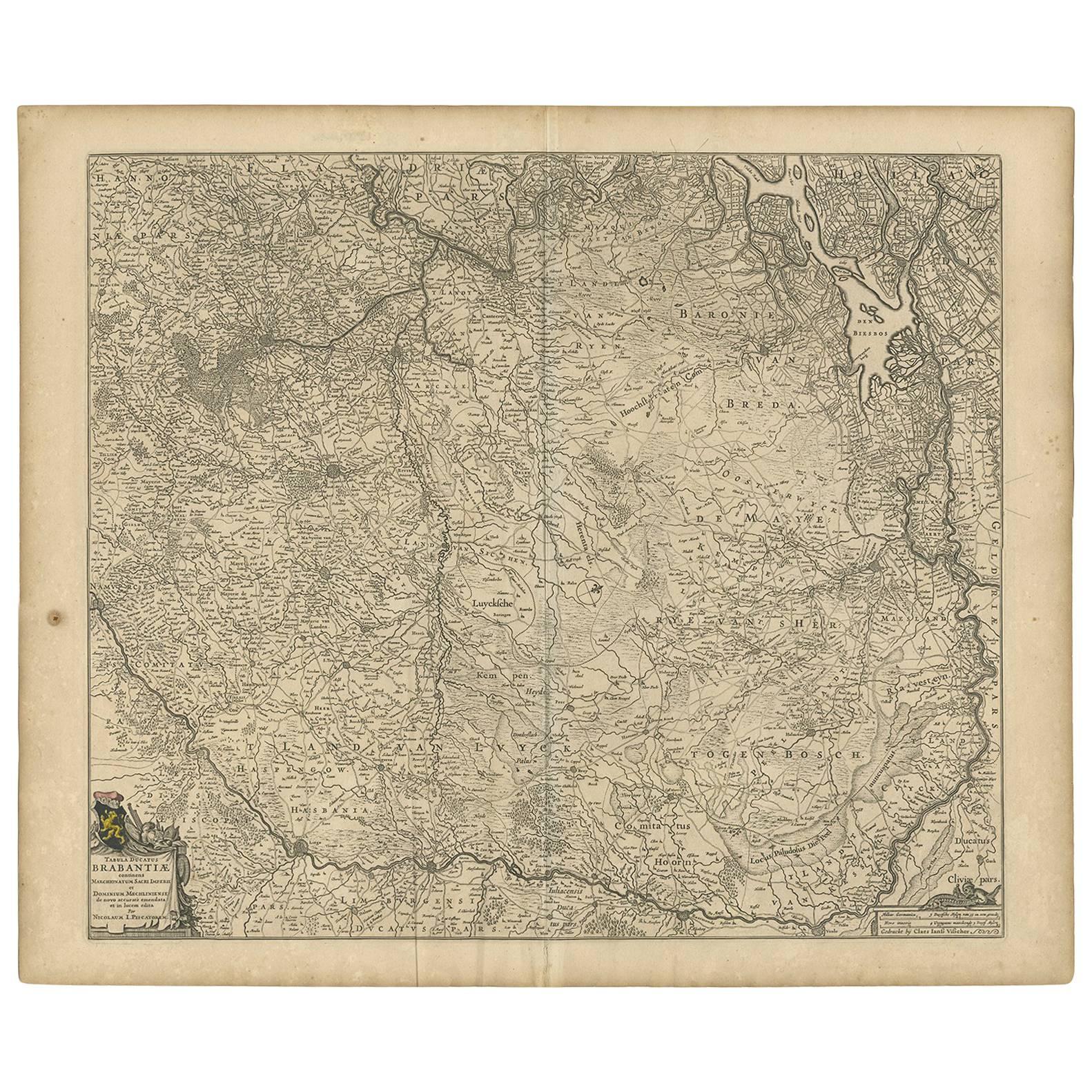
Antique Map of Brabant 'The Netherlands' by N. Visscher, circa 1670
Located in Langweer, NL
Detailed map of the southern part of The Netherlands and the northern part of Belgium with Antwerp and Brussels. In the corner top left in Holland with Rotterdam partly on the map. S...
Category
Antique Mid-17th Century Maps
Materials
Paper
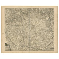
$593 Sale Price
20% Off
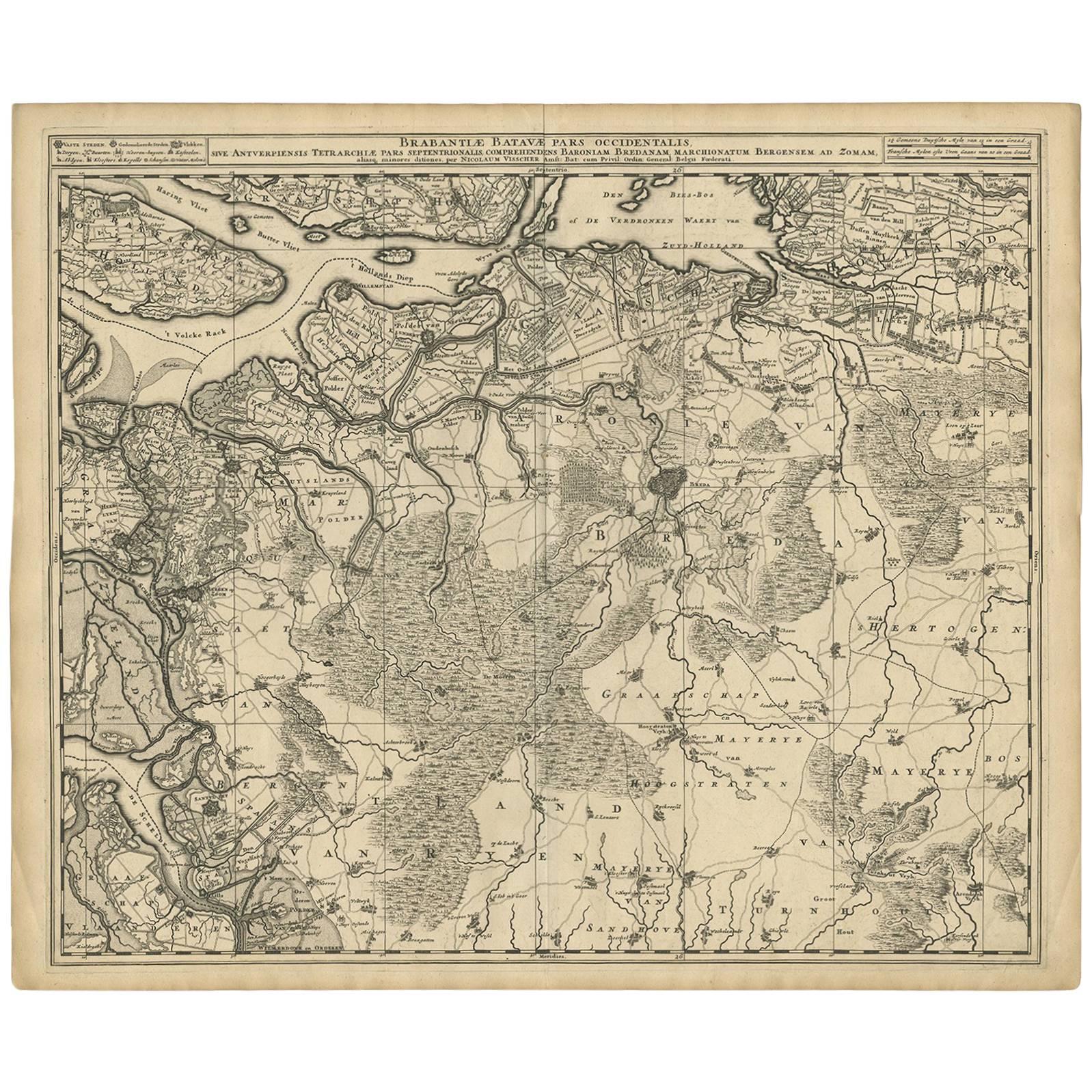
Antique Map of Brabant 'The Netherlands' by N. Visscher, circa 1690
Located in Langweer, NL
Antique map titled 'Brabantiae Batavae Pars Occidentalis (..)'. Highly detailed map of the region between Bergen Op Zoom, Breda, Hoogstraten and Sandvliet, The Netherlands. Published...
Category
Antique Late 17th Century Maps
Materials
Paper
$632 Sale Price
20% Off
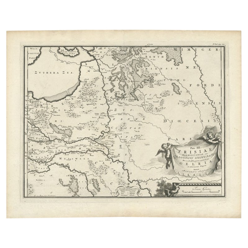
Antique Map of the Dutch Province of Gelderland, 1725
Located in Langweer, NL
Antique map titled 'Frisiae Haereditariae seu Trajectini Episcopatus Gelria?. Map of the province of Gelderland, the Netherlands. This map originates from 'Atlas Descriptio, secundum...
Category
Antique 18th Century Maps
Materials
Paper
$122 Sale Price
20% Off
Antique Map of The Dutch Province of Groningen by De Wit, c.1680
Located in Langweer, NL
Antique map titled 'Tabulae dominii Groeningae quae et complecitur maximam partem Drentiae Emendata'.
Old map of the province of Groningen, the Netherlands. With an inset map of th...
Category
Antique 17th Century Maps
Materials
Paper

$685 Sale Price
20% Off
You May Also Like
1643 Willem&Joan Blaeu Map NW Flanders "Flandriae Teutonicae Pars Prientalior
Located in Norton, MA
1643 Willem and Joan Blaeu map of northwest Flanders, entitled
"Flandriae Teutonicae Pars Prientalior,"
Ric0012
" Authentic" - Map of the northwest Fl...
Category
Antique 17th Century Dutch Maps
Materials
Paper

1646 Jansson Map Entitled "Procinvia Connactiae, " Ric.a006
Located in Norton, MA
1646 Jansson map entitled
"Procinvia connactiae,"
Ric.a006
Description: The PROVINCE of CONNAVGT 490 x 380From vol 4 of Jansson's Atlas Novus 1646, published in Amsterdam with...
Category
Antique 17th Century Unknown Maps
Materials
Paper

Rare Original Map of New Amsterdam (New York) – “Restitutio”, ca. 1674 –
Located in Dronten, NL
An exceptionally rare and original 17th-century engraving of New Amsterdam, now New York City, published by the renowned Amsterdam cartographer Carel (Carolus) Allard around 1674. Kn...
Category
Antique 17th Century Dutch Maps
Materials
Paper

17th Century Hand Colored Map of the Liege Region in Belgium by Visscher
By Nicolaes Visscher II
Located in Alamo, CA
An original 17th century map entitled "Leodiensis Episcopatus in omnes Subjacentes Provincias distincté divisusVisscher, Leodiensis Episcopatus" by Nicolaes Visscher II, published in Amsterdam in 1688. The map is centered on Liege, Belgium, includes the area between Antwerp, Turnhout, Roermond, Cologne, Trier and Dinant.
This attractive map is presented in a cream-colored mat measuring 30" wide x 27.5" high. There is a central fold, as issued. There is minimal spotting in the upper margin and a tiny spot in the right lower margin, which are under the mat. The map is otherwise in excellent condition.
The Visscher family were one of the great cartographic families of the 17th century. Begun by Claes Jansz Visscher...
Category
Antique Late 17th Century Dutch Maps
Materials
Paper

1752 Vaugoundy Map of Flanders : Belgium, France, and the Netherlands, Ric.a002
Located in Norton, MA
Large Vaugoundy Map of Flanders:
Belgium, France, and the Netherlands
Colored -1752
Ric.a002
Description: This is a 1752 Didier Robert de Vaugondy map of Flanders. The map de...
Category
Antique 17th Century Unknown Maps
Materials
Paper

1654 Joan Blaeu Map the Sutherland, Scotland, Entitled "Southerlandia, "Ric0007
Located in Norton, MA
1654 Joan Blaeu map of the
Sutherland, Scotland, entitled
"Southerlandia,"
Hand Colored
Ric0007
Description:
Lovely map centered on Sedan and D...
Category
Antique 17th Century Dutch Maps
Materials
Paper

More Ways To Browse
Carved Cabriole Table
Dark Antique Table
Antique Wall Table
1960 Chair Wood Danish
Unusual Dining Table
Antique Dutch Plates
Mdf Table
Showcase Coffee Table
Space Age Orange
Vallauris France
Silver Ladle
Scalloped Table
Brazil Wood Chairs
Vintage Art Deco Side Tables
Window Display
1960s Cushion Chair
Green Brown Oriental Rug
Authentic Models