Items Similar to Antique Map of North and South America by Pierre Antoine Tardieu (1784-1869)
Want more images or videos?
Request additional images or videos from the seller
1 of 9
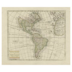
Antique Map of North and South America by Pierre Antoine Tardieu (1784-1869)
$491.48
$614.3620% Off
£368.40
£460.5020% Off
€416
€52020% Off
CA$675.22
CA$844.0220% Off
A$753.81
A$942.2720% Off
CHF 394.99
CHF 493.7320% Off
MX$9,227.44
MX$11,534.2920% Off
NOK 5,016.35
NOK 6,270.4420% Off
SEK 4,729.78
SEK 5,912.2220% Off
DKK 3,166.74
DKK 3,958.4320% Off
Shipping
Retrieving quote...The 1stDibs Promise:
Authenticity Guarantee,
Money-Back Guarantee,
24-Hour Cancellation
About the Item
This is an original antique map titled "Carte Générale et Politique de l'Amérique," depicting the political and geographical features of North and South America. This map, created by Pierre Antoine Tardieu, illustrates the continent's boundaries, major regions, and significant features as understood in the early 19th century.
Map Details:
- **Title**: Carte Générale et Politique de l'Amérique
- **Creator**: Pierre Antoine Tardieu (1784-1869)
- **Publication Date**: Early 19th century
- **Dimensions**: Approximately 34.5 x 43.5 cm (13.5 x 17.25 inches)
- **Features**: The map includes detailed representations of North and South America, highlighting political boundaries, major cities, rivers, and mountain ranges. The title cartouche is located in the lower right corner, and the outlines are hand-colored to distinguish different regions and countries.
Condition Overview:
1. Paper Quality: The paper shows typical signs of aging, such as slight yellowing, but remains in good condition without major tears or damage.
2. Edges and Corners: The edges are slightly worn, with minor fraying and small tears, particularly near the center fold. These imperfections do not significantly impact the overall readability or aesthetic value.
3. Center Fold: A center fold is present, which is common for maps of this period that were often folded for storage or publication. The fold appears intact without significant separation or damage, except for a small split at the lower end.
4. Color and Print Quality: The hand-colored outlines remain vibrant and clear, highlighting the borders of different regions. The print quality is excellent, with sharp, legible text and detailed illustrations.
5. Staining and Spots: There are a few spots and stains, particularly near the edges and along the fold. These do not obscure any critical details of the map.
Historical Context
Around the year 1800, the Americas were a region of significant political change and exploration. Here’s an overview of the region during that period:
Political Landscape
1. North America:
- United States: The United States was a young nation, having gained independence from Great Britain in 1776. The early 19th century was a period of westward expansion and the establishment of new states.
- Canada: Canada was divided into British colonies, including Upper Canada (Ontario) and Lower Canada (Quebec). The British maintained control over these territories following the American Revolution.
- Mexico: Mexico was part of the Spanish Empire, known as New Spain. It would gain independence from Spain in 1821.
2. Central and South America:
- Spanish Colonies: Much of Central and South America was under Spanish colonial rule. Significant regions included New Granada (Colombia), Peru, and the Viceroyalty of the Rio de la Plata (Argentina).
- Portuguese Brazil: Brazil was a Portuguese colony and the largest territory in South America. It would gain independence from Portugal in 1822.
- Independence Movements: The early 19th century was marked by independence movements across Latin America, led by figures such as Simón Bolívar and José de San Martín, which resulted in the creation of new nations.
3. Caribbean:
- The Caribbean islands were controlled by various European powers, including Spain, France, Great Britain, and the Netherlands. These islands were significant for their sugar plantations and as hubs of the Atlantic slave trade.
Socio-Economic Conditions
1. Trade and Commerce:
- The Americas were integral to global trade, exporting commodities such as sugar, tobacco, cotton, and coffee. The port cities of Havana, Veracruz, and Buenos Aires were crucial trade centers.
- The transatlantic slave trade was a tragic and significant part of the economy, particularly in the Caribbean and southern United States.
2. Agriculture and Resources:
- Agriculture was the dominant economic activity, with plantations in the south and central regions producing key exports.
- The early 19th century also saw the beginning of the Industrial Revolution's impact on the Americas, with increasing demand for raw materials.
Cultural and Social Aspects
1. Diverse Populations:
- The population of the Americas was diverse, including Indigenous peoples, European settlers, African slaves, and mixed-race communities.
- Cultural exchange and conflict were common as different groups interacted and contested control over territories.
2. Colonial Influence:
- European colonial powers influenced the cultural, religious, and social structures of the Americas. Spanish, Portuguese, French, and British customs and governance systems shaped the development of new societies.
Conflicts and Changes
1. Independence Wars:
- The early 19th century was a period of intense conflict as colonies sought independence from European powers. These wars reshaped the political landscape of the Americas.
- The Haitian Revolution (1791-1804) was a significant event, leading to the first successful slave rebellion and the establishment of Haiti as an independent nation.
2. Territorial Expansion:
- The United States pursued westward expansion, acquiring new territories through treaties, purchases, and conflicts, such as the Louisiana Purchase (1803) and the War of 1812.
Summary
The Americas around 1800 were a region of dynamic political change, economic activity, and cultural diversity. The map by Pierre Antoine Tardieu provides a detailed and historically valuable representation of this transformative period, reflecting the geographical and political complexities of North and South America.
- Dimensions:Height: 16.34 in (41.5 cm)Width: 22.25 in (56.5 cm)Depth: 0.01 in (0.2 mm)
- Materials and Techniques:Paper,Engraved
- Period:
- Date of Manufacture:1802
- Condition:Good condition with minor age-related wear. Hand-colored boundaries are well-preserved, enhancing the clarity of regions and features. Fold lines as issued with lower end a split. Edge wear due to handling and age visible. Study the images carefully.
- Seller Location:Langweer, NL
- Reference Number:Seller: BG-13769-331stDibs: LU3054340566092
About the Seller
5.0
Recognized Seller
These prestigious sellers are industry leaders and represent the highest echelon for item quality and design.
Platinum Seller
Premium sellers with a 4.7+ rating and 24-hour response times
Established in 2009
1stDibs seller since 2017
2,511 sales on 1stDibs
Typical response time: <1 hour
- ShippingRetrieving quote...Shipping from: Langweer, Netherlands
- Return Policy
Authenticity Guarantee
In the unlikely event there’s an issue with an item’s authenticity, contact us within 1 year for a full refund. DetailsMoney-Back Guarantee
If your item is not as described, is damaged in transit, or does not arrive, contact us within 7 days for a full refund. Details24-Hour Cancellation
You have a 24-hour grace period in which to reconsider your purchase, with no questions asked.Vetted Professional Sellers
Our world-class sellers must adhere to strict standards for service and quality, maintaining the integrity of our listings.Price-Match Guarantee
If you find that a seller listed the same item for a lower price elsewhere, we’ll match it.Trusted Global Delivery
Our best-in-class carrier network provides specialized shipping options worldwide, including custom delivery.More From This Seller
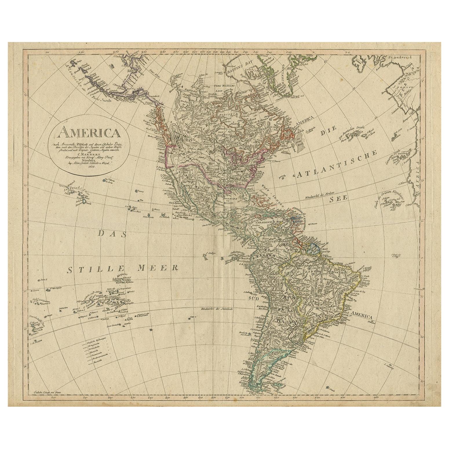
View AllAntique Map of North and South America by Schneider and Weigel, 1818
Located in Langweer, NL
Antique map titled 'America nach Arrowsmiths Weltcharte und dessen Globular Projection (..)'. Map of North and South America. Published by Schneider and Weigel, 1818.
Category
Antique Early 19th Century Maps
Materials
Paper

$1,240 Sale Price
30% Off
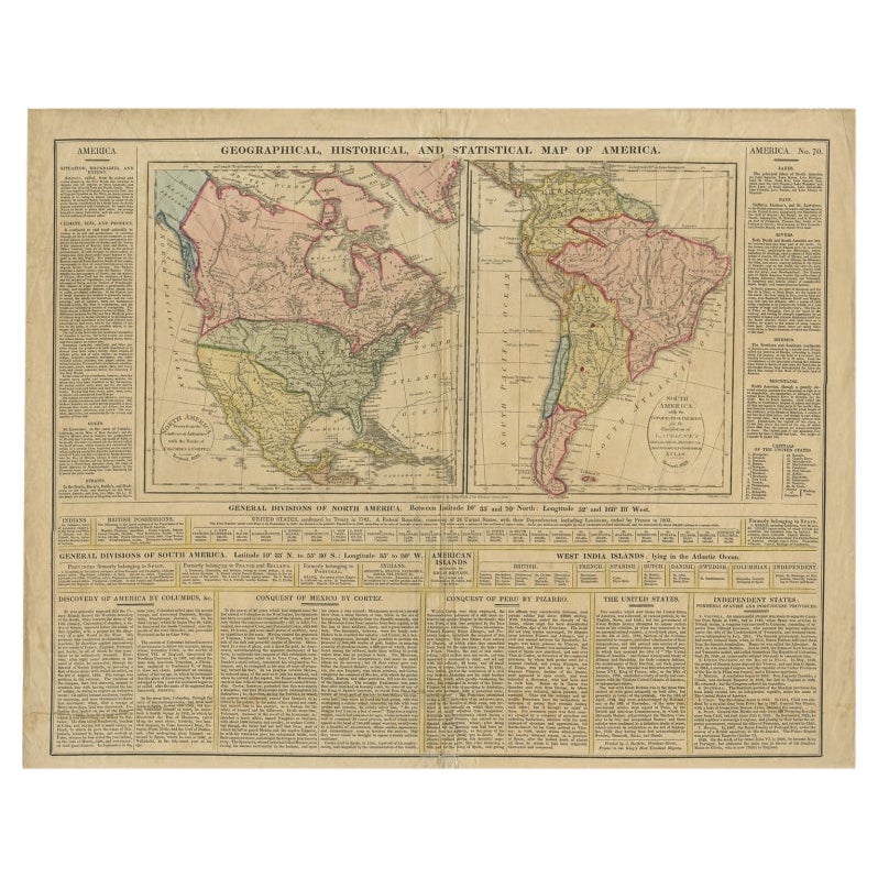
Antique Map of North and South America by Walker, 1828
Located in Langweer, NL
Antique map titled 'Geographical, Historical and Statistical Map of America'. Two maps on one sheet depicting North and South America. Text provides a lot of information about the Am...
Category
Antique 19th Century Maps
Materials
Paper

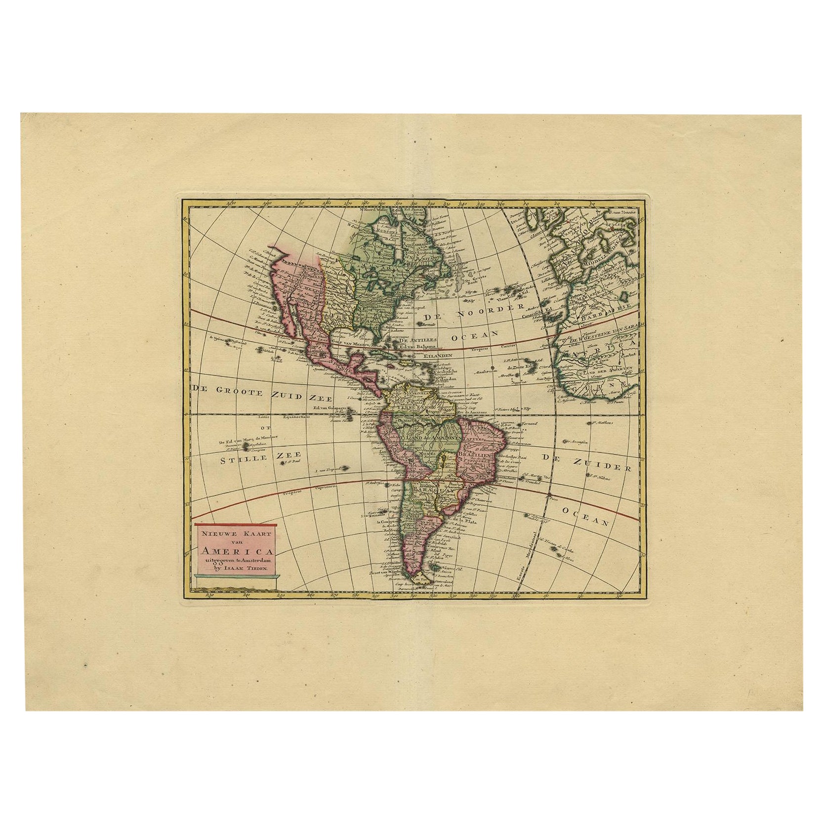
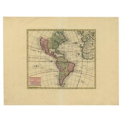
Very Attractive Map of North and South America and Western Part of Africa, 1744
Located in Langweer, NL
Antique map titled 'Nieuwe Kaart van America.' Very attractive map of North and South America, the western part of Africa and south west Europe. With full contemporary hand colouring...
Category
Antique 18th Century Maps
Materials
Paper
$897 Sale Price
20% Off
Decorative Dutch Antique Map of North and South America, 1841
Located in Langweer, NL
Description: Antique map titled 'Amerika'. Small map of North and South America.
This map originates from the Dutch publication 'De Aarde, beschouwd in haren Natuurlijken Toestan...
Category
Antique 1840s Maps
Materials
Paper
$330 Sale Price
20% Off
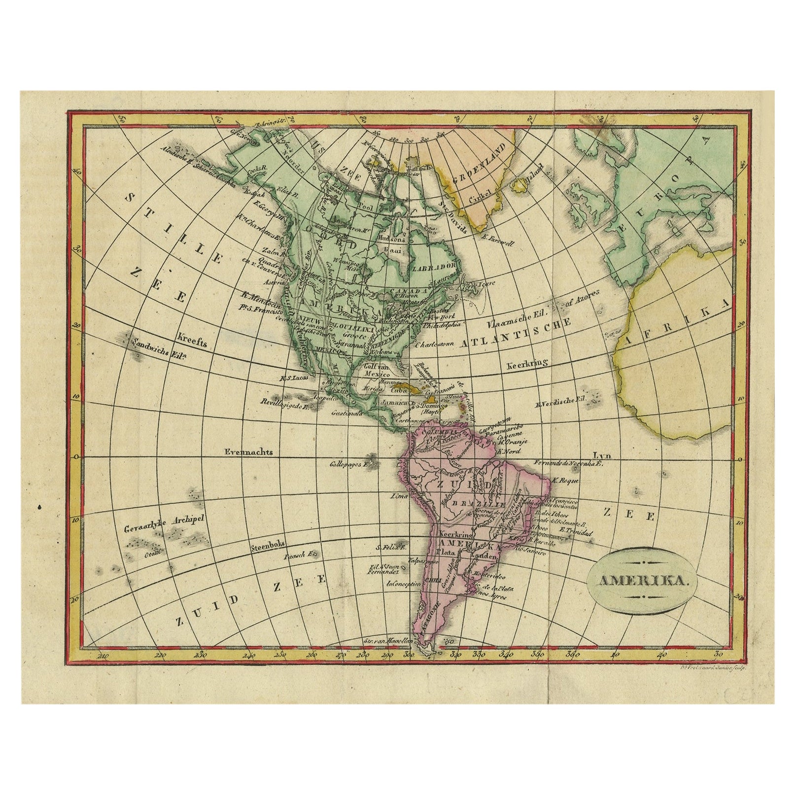
Original Antique Map of North and South America in Attractive Old Coloring
By Isaak Tirion
Located in Langweer, NL
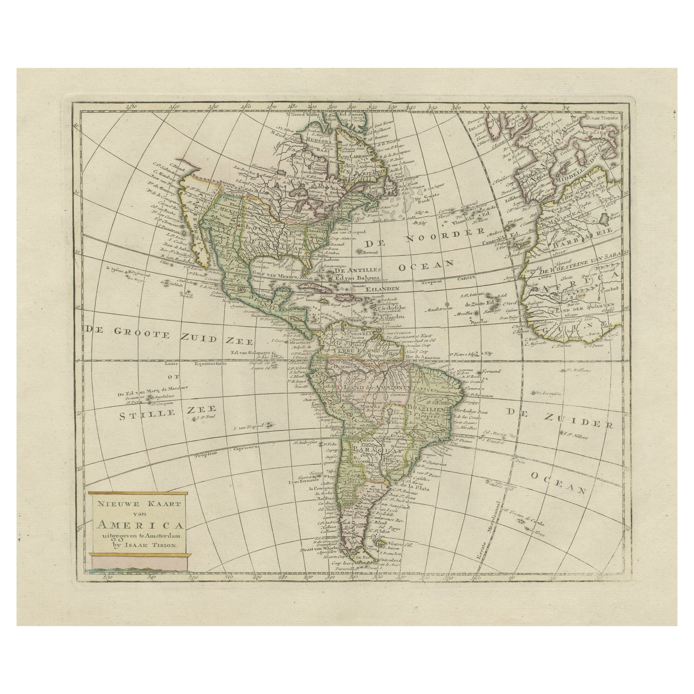
Antique map titled 'Nieuwe Kaart van America'. Beautiful map of America. The fabled Quivira is used to name a large mountain range placed just north of M...
Category
Antique Mid-18th Century Maps
Materials
Paper
$935 Sale Price
20% Off
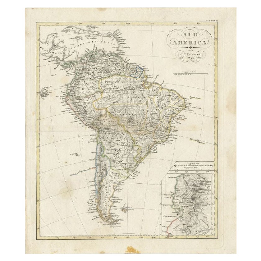
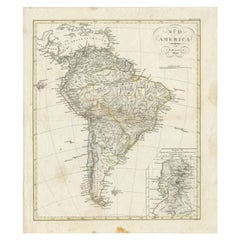
Antique Map of South America by Reichard, 1820
By Thomas Kitchin
Located in Langweer, NL
Antique map titled 'Süd America'. Decorative antique map of South America with an inset map of Ecuador. Artists and Engravers: Published b...
Category
Antique 19th Century Maps
Materials
Paper
$83 Sale Price
20% Off
You May Also Like
Original Antique Map of The Western Hemisphere by Dower, circa 1835
Located in St Annes, Lancashire
Nice map of the Western Hemisphere
Drawn and engraved by J.Dower
Published by Orr & Smith. C.1835
Unframed.
Free shipping
Category
Antique 1830s English Maps
Materials
Paper

North & South America: A 17th Century Hand-colored Map by Jansson & Goos
By Johannes Janssonius
Located in Alamo, CA
A 17th century hand-colored map of North & South America entitled "Americae Descriptio" by the cartographer Johannes Jansson, published in Jansson's Atlas Minor in Amsterdam in 1628....
Category
Antique 1620s Dutch Maps
Materials
Paper

Original Antique Map of South America. C.1780
Located in St Annes, Lancashire
Great map of South America
Copper-plate engraving
Published C.1780
Two small worm holes to left side of map
Unframed.
Category
Antique Early 1800s English Georgian Maps
Materials
Paper

Original Antique Map of The World by Thomas Clerk, 1817
Located in St Annes, Lancashire
Great map of The Eastern and Western Hemispheres
On 2 sheets
Copper-plate engraving
Drawn and engraved by Thomas Clerk, Edinburgh.
Published by Mackenzie And Dent, 1817
...
Category
Antique 1810s English Maps
Materials
Paper

North and South America: An 18th Century Hand-colored Map by Johann Homann
By Johann Baptist Homann
Located in Alamo, CA
This early 18th century hand-colored copperplate map of North and South America entitled "Totius Americae Septentrionalis Et Meridionalis Novissima Repraesentatio" was created by Johann Baptist Homann and published in Nuremberg, Germany, between 1710 and 1731. The map details cities, forts, mountains, forests and lakes, as well as districts. There is a decorative cartouche in the lower left which depicts a volcano, scenes representing the people in their native costumes, as well as animals and plants of the Americas. A village is seen in the background on the left. A second smaller decorative cartouche in the upper right includes text and a series of allegorical figures. A large portion if the north central and western portions of North America is left without detail, because the region was largely unexplored at the time this map was created. The map also shows "Terra Esonis Incognita", representing a mythical continuous land bridge from North America to Asia, a northwest passage. The map preceded the French and...
Category
Early 18th Century Old Masters Landscape Prints
Materials
Engraving

Charte von Sud-America (Map of South America) - Etching with Hand-Drawn Outlines
Located in Soquel, CA
Map of south America, engraved by Franz Pluth (Czech, 1800-1871), from the book "Neueste Länder - und Völkerkunde, ein geographisches Lesebuch für alle Stände" by Linder, F. L. (Prag...
Category
1820s Other Art Style More Prints
Materials
Paper, Printer's Ink, Etching

More Ways To Browse
Latin American Furniture
Southern Colonial
African American Antique
South African Antique
Antique Furniture South Africa
African American 19th Century
Latin America Antique
Map Storage
Peruvian Antiques
War Of 1812
Brazilian Colonial Furniture
Peruvian Colonial
Portuguese Colonial Furniture
Antique Plantation Furniture
Colonial Peru
Latin American Colonial Furniture
Antique Mexican Religious
Antique Map Storage