Items Similar to Antique Map of the Northeastern United States and Canada by Tardieu, 1802


Want more images or videos?
Request additional images or videos from the seller
1 of 9
Antique Map of the Northeastern United States and Canada by Tardieu, 1802
$537.23
$671.5420% Off
£399.65
£499.5620% Off
€448
€56020% Off
CA$735.65
CA$919.5720% Off
A$817.95
A$1,022.4320% Off
CHF 427.09
CHF 533.8620% Off
MX$9,956.42
MX$12,445.5220% Off
NOK 5,449.45
NOK 6,811.8120% Off
SEK 5,105.87
SEK 6,382.3420% Off
DKK 3,410.38
DKK 4,262.9720% Off
Shipping
Retrieving quote...The 1stDibs Promise:
Authenticity Guarantee,
Money-Back Guarantee,
24-Hour Cancellation
About the Item
This antique map titled "Carte de la Partie Septentrionale des Etats Unis," created by Pierre Antoine Tardieu, depicts the northeastern part of the United States and parts of Canada. It focuses on the New England region, New York, and the surrounding areas, providing a detailed view of the geographical and political landscape of the early 19th century.
Map Details:
- Title: Carte de la Partie Septentrionale des Etats Unis
- Creator: Pierre Antoine Tardieu (1784-1869)
- Publication Date: Early 19th century
- Dimensions: Approximately 34.5 x 43.5 cm (13.5 x 17.25 inches)
- Features: The map includes detailed representations of the northeastern United States and parts of Canada, highlighting political boundaries, major cities, rivers, and other geographical features. The title cartouche is located in the lower right corner, and the outlines are hand-colored to distinguish different regions and states.
States and Provinces Mentioned:
The map covers various states in the northeastern United States and parts of Canada, including:
1. New England States:
- **Maine** (part of Massachusetts until 1820)
- **New Hampshire**
- **Vermont**
- **Massachusetts**
- **Rhode Island**
- **Connecticut**
2. Middle Atlantic States:
- **New York**
- **New Jersey** (partially depicted)
3. Canada:
- **Newfoundland** (now Newfoundland and Labrador)
- **Nova Scotia**
- **New Brunswick**
- **Quebec**
Condition Overview:
1. Paper Quality: The paper shows typical signs of aging, such as slight yellowing, but remains in good condition without major tears or damage.
2. Edges and Corners: The edges are slightly worn, with minor fraying and small tears, particularly near the center fold. These imperfections do not significantly impact the overall readability or aesthetic value.
3. Center Fold: A center fold is present, which is common for maps of this period that were often folded for storage or publication. The fold appears intact without significant separation or damage.
4. Color and Print Quality: The hand-colored outlines remain vibrant and clear, highlighting the borders of different regions. The print quality is excellent, with sharp, legible text and detailed illustrations.
5. Staining and Spots: There are a few spots and stains, particularly near the edges and along the fold. These do not obscure any critical details of the map.
Historical Context
Political Landscape
1. United States:
- The map depicts the northeastern United States during a period of significant growth and development following the American Revolution.
- Key cities like Boston, New York, and Philadelphia (though not fully visible) were major centers of commerce and political activity.
2. Canada:
- The Canadian regions, under British control, include Newfoundland, Nova Scotia, New Brunswick, and Quebec. These areas were important for their fisheries, trade routes, and as points of British military presence.
Socio-Economic Conditions
1. Agriculture and Industry:
- The economy in the northeastern United States was a mix of agriculture, trade, and emerging industries. The fertile lands of New England and New York supported farming communities.
- Shipbuilding, fishing, and early industrial activities were significant in coastal areas.
2. Trade and Commerce:
- Major port cities like Boston and New York were crucial hubs for trade with Europe, the Caribbean, and other parts of the Americas.
- Inland trade routes, including rivers and early roads, facilitated commerce within the region.
Cultural and Social Aspects
1. Population Growth:
- The population in the northeastern United States was growing rapidly due to high birth rates and immigration from Europe. This growth was driving westward expansion and the establishment of new settlements.
- The map reflects this expansion, showing the growing network of towns and cities.
2. Diverse Population:
- The region was home to a diverse population, including European settlers, Indigenous peoples, and African Americans.
- Cultural and social structures varied widely, from the Puritan communities of New England to the more diverse and cosmopolitan cities like New York.
Conflicts and Changes
1. Native American Relations:
- The westward expansion often led to conflicts with Indigenous peoples, resulting in displacement and treaties that were frequently broken by settlers.
- The map may depict some of these territories and regions under Native American control or influence.
2. Political Developments:
- The early 19th century was a period of political change, with the establishment of the federal government and the development of political parties.
- Key events such as the War of 1812 with Britain and the subsequent changes in policy are part of this era.
Summary
The northeastern United States and parts of Canada around 1800 were regions of dynamic political change, economic activity, and cultural diversity. The map by Pierre Antoine Tardieu provides a detailed and historically valuable representation of this transformative period, reflecting the geographical and political complexities of the region.
- Dimensions:Height: 16.34 in (41.5 cm)Width: 22.25 in (56.5 cm)Depth: 0.01 in (0.2 mm)
- Materials and Techniques:Paper,Engraved
- Period:
- Date of Manufacture:1802
- Condition:Good condition with minor age-related wear. Hand-colored boundaries are well-preserved, enhancing the clarity of regions and features. Fold lines as issued. Damp spot at bottom edge. Some wear due to handling and age. Study the images carefully.
- Seller Location:Langweer, NL
- Reference Number:Seller: BG-13769-351stDibs: LU3054340567272
About the Seller
5.0
Recognized Seller
These prestigious sellers are industry leaders and represent the highest echelon for item quality and design.
Platinum Seller
Premium sellers with a 4.7+ rating and 24-hour response times
Established in 2009
1stDibs seller since 2017
2,511 sales on 1stDibs
Typical response time: <1 hour
- ShippingRetrieving quote...Shipping from: Langweer, Netherlands
- Return Policy
Authenticity Guarantee
In the unlikely event there’s an issue with an item’s authenticity, contact us within 1 year for a full refund. DetailsMoney-Back Guarantee
If your item is not as described, is damaged in transit, or does not arrive, contact us within 7 days for a full refund. Details24-Hour Cancellation
You have a 24-hour grace period in which to reconsider your purchase, with no questions asked.Vetted Professional Sellers
Our world-class sellers must adhere to strict standards for service and quality, maintaining the integrity of our listings.Price-Match Guarantee
If you find that a seller listed the same item for a lower price elsewhere, we’ll match it.Trusted Global Delivery
Our best-in-class carrier network provides specialized shipping options worldwide, including custom delivery.More From This Seller
View AllAntique Map of New England and Part of Canada by Vaugondy 'circa 1755'
Located in Langweer, NL
Antique map titled 'Partie de l'Amérique septent qui comprend la nouvelle France ou le Canada'. Decorative and highly detailed map of New England an...
Category
Antique Mid-18th Century Maps
Materials
Paper

$1,574 Sale Price
24% Off
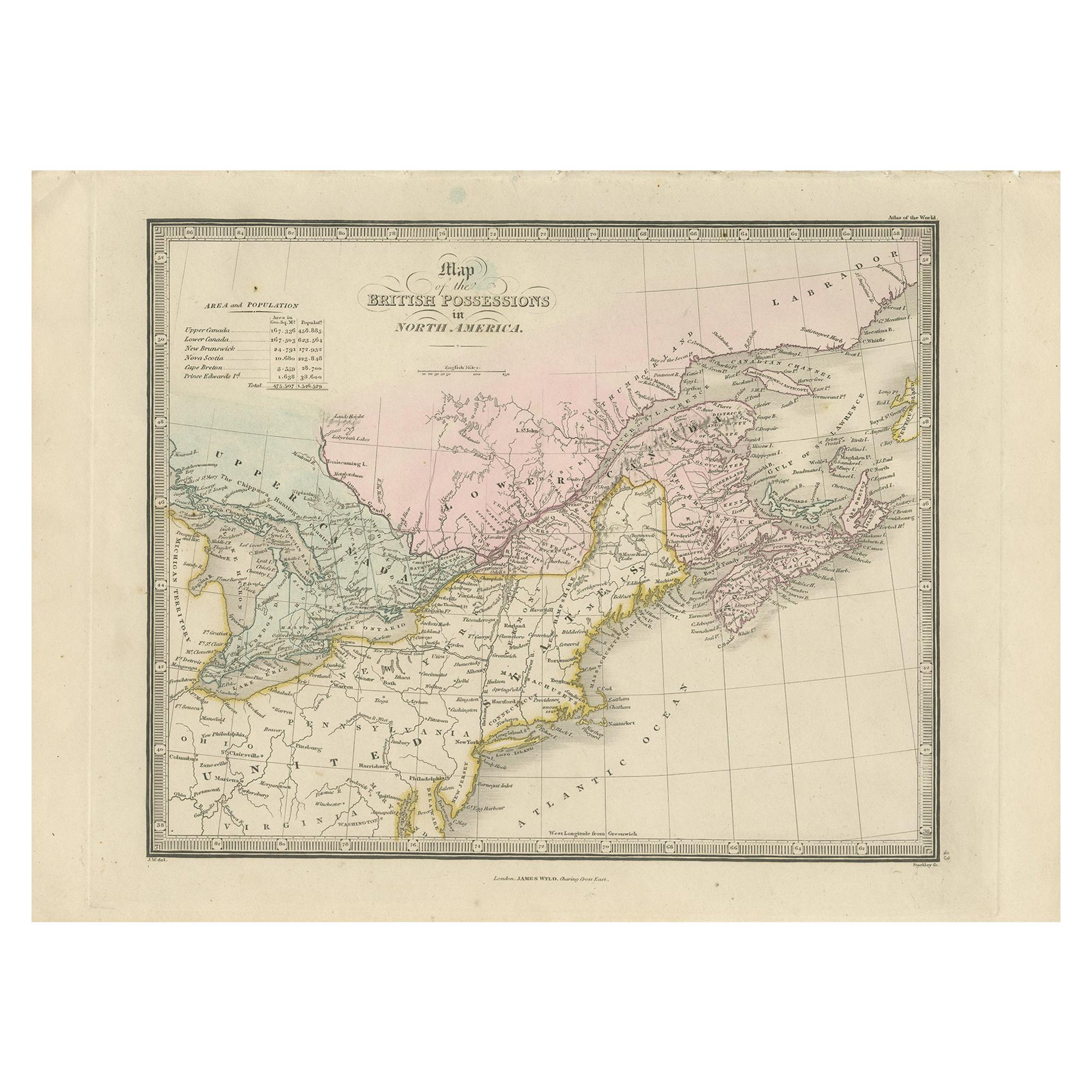
Antique Map of the British Possessions in North America by Wyld '1845'
Located in Langweer, NL
Antique map titled 'Map of The British Possessions in North America'. Original antique map of the British Possessions in North America. This map originates from 'An Atlas of the Worl...
Category
Antique Mid-19th Century Maps
Materials
Paper
$191 Sale Price
20% Off
Antique Map of New England and Eastern Canada by Homann Heirs, circa 1755
Located in Langweer, NL
Antique map titled 'Partie Orientale de la Nouvelle France ou du Canada (..)'. Original antique map of New England and Eastern Canada made a...
Category
Antique Mid-18th Century Maps
Materials
Paper
$1,798 Sale Price
25% Off
Antique Map Dedicated to British Merchants Trading to North America, ca.1746
Located in Langweer, NL
Description: Antique map titled 'A New Chart of the Coast of New England, Nova Scotia, New France or Canada, with the islands of Newfoundland, Capte Breton, St John's (..)'. Map stre...
Category
Antique 1740s Maps
Materials
Paper
$815 Sale Price
20% Off
Antique Map of New Brunswick, Nova Scotia and Surroundings by Johnson, 1872
Located in Langweer, NL
Antique map titled 'Johnson's Quebec, of the dominion of Canada (..)'. Original map of New Brunswick, Nova Scotia, Newfoundland and Prince Edward Island....
Category
Antique Late 19th Century Maps
Materials
Paper

$335 Sale Price
20% Off
Antique Map of North America, 1821
Located in Langweer, NL
Antique map of America titled 'Carte de l'Amerique septentrionale'. Scarce map of North America, shortly after the Louisiana Purchase and the first ...
Category
Antique 19th Century Maps
Materials
Paper

$623 Sale Price
20% Off
You May Also Like
English Engraved Hand Colored Map of the North Eastern United States, circa 1817
Located in Charleston, SC
English copper engraved hand colored map of the North Eastern United States matted under glass in a gilt frame, Early 19th Century. Drawn and Engraved for Thomson's New General Atlas...
Category
Antique 1810s English George III Maps
Materials
Glass, Giltwood, Paint, Paper

Original Antique Map of New Brunswick and Nova Scotia, 1889
Located in St Annes, Lancashire
Great map of New Brunswick and Nova Scotia
Drawn and Engraved by W. & A.K. Johnston
Published By A & C Black, Edinburgh.
Original colour
Unfr...
Category
Antique 1880s Scottish Victorian Maps
Materials
Paper

Original Antique Map of The United States of America by Dower, circa 1835
Located in St Annes, Lancashire
Nice map of the USA
Drawn and engraved by J.Dower
Published by Orr & Smith. C.1835
Unframed.
Free shipping
Category
Antique 1830s English Maps
Materials
Paper

Original Antique Map of United States, Grattan and Gilbert, 1843
Located in St Annes, Lancashire
Great map of United States
Drawn and engraved by Archer
Published by Grattan and Gilbert. 1843
Original colour
Unframed.
Category
Antique 1840s English Maps
Materials
Paper

Early 19th Century Hand Coloured Map of North America by Aaron Arrowsmith
By Aaron Arrowsmith
Located in Hamilton, Ontario
Hand coloured map in French by English cartographer Aaron Arrowsmith (1750–1823) titled "Amerique Septentionale" (North America).
Map size: 9.5" x 8"
Mat size: 20.5" x 14.25".
Category
Antique Early 19th Century English Maps
Materials
Paper

$795 Sale Price
36% Off
Original Antique Map of North America by Dower, circa 1835
Located in St Annes, Lancashire
Nice map of North America
Drawn and engraved by J.Dower
Published by Orr & Smith. C.1835
Unframed.
Free shipping
Category
Antique 1830s English Maps
Materials
Paper

More Ways To Browse
Canadian Antique Furniture
African American Antique
The Puritan
Used Office Furniture Rhode Island
Map Storage
Antique Fishing Collectables
War Of 1812
African Birthing
Antique Vermont
Antique Furniture Brunswick
Used Furniture Nova Scotia
Vermont Antique Furniture
Antique Furniture Newfoundland
Antique Map Storage
Antique Labrador
Huber Canada
Silver Over Copper
Vintage Barware Glasses