Items Similar to Antique Map of Peloponnesus, Greece by Pierre Antoine Tardieu, 1797


Want more images or videos?
Request additional images or videos from the seller
1 of 7
Antique Map of Peloponnesus, Greece by Pierre Antoine Tardieu, 1797
$325.90
$407.3720% Off
£242.61
£303.2620% Off
€272
€34020% Off
CA$446.39
CA$557.9920% Off
A$496.49
A$620.6120% Off
CHF 259.25
CHF 324.0620% Off
MX$6,041.74
MX$7,552.1720% Off
NOK 3,311.03
NOK 4,138.7920% Off
SEK 3,105.16
SEK 3,881.4520% Off
DKK 2,070.64
DKK 2,588.3020% Off
Shipping
Retrieving quote...The 1stDibs Promise:
Authenticity Guarantee,
Money-Back Guarantee,
24-Hour Cancellation
About the Item
This antique map, titled "Carte Ancienne d'Allemagne," represents ancient Germany and surrounding regions. It was published by the well-known Parisian mapmakers and publishers Jean-Baptiste-Louis Clouet and Alexandre Aimé Vuillemin in the late 18th century, specifically in 1787.
The map covers the extensive geographical area of ancient Germany, highlighting various tribes and regions known at the time. Key features include:
1. **Geographical Boundaries**: The map outlines the territorial extents of ancient Germany, bordered by Gallia (France) to the west, Sarmatia (parts of Eastern Europe) to the east, and the Italian regions to the south. The northern boundary reaches the Oceanus Germanicus (North Sea) and the Sarmatian Sea (Baltic Sea).
2. **Tribal Regions**: It details numerous ancient Germanic tribes and their respective regions, including the Franks, Saxons, Bavarians, Swabians, and others. These tribal boundaries are marked with distinct colors for easier differentiation.
3. **Topographical Details**: The map includes topographical features such as mountains, rivers, and forests. Notable mountain ranges and rivers, which played crucial roles in ancient Germanic history, are carefully illustrated.
4. **Cartouche and Inscriptions**: The title cartouche in the lower right corner of the map provides the map’s title, publication details, and the mapmakers’ names. The inscriptions on the map are in French, reflecting the linguistic and cultural context of the publishers.
5. **Scale and Coordinates**: The map features a scale bar and longitude and latitude lines for precise geographical referencing, demonstrating the scientific approach to cartography during the period.
This map is a valuable historical document, offering insights into the geographical and political landscape of ancient Germany as understood in the late 18th century. It not only serves as a tool for historical study but also stands as an artifact of cartographic art, reflecting the meticulous work of mapmakers like Clouet and Vuillemin.
Jean-Jacques Mentelle and Pierre-Gilles Chanlaire are mentioned on the map because they were influential geographers and cartographers in the late 18th century who contributed to its creation and publication.
1. **Jean-Jacques Mentelle (1730-1799)**: A renowned French geographer and historian, Mentelle was known for his contributions to geography and cartography during the Enlightenment period. His works often focused on providing detailed geographical knowledge and education. His involvement in the map indicates that it was produced with a high level of scholarly input, reflecting the latest geographical understanding of the time.
2. **Pierre-Gilles Chanlaire (1758-1817)**: A contemporary of Mentelle, Chanlaire was also a respected geographer and cartographer. He collaborated with Mentelle on various cartographic projects and was known for his detailed and accurate maps. His inclusion on the map signifies his role in its design, research, or publication process.
Their collaboration would have brought together significant expertise and resources, ensuring that the map was both accurate and informative. The mention of their names on the map serves to credit their contributions and to add authority and credibility to the map, which would have been important for its acceptance and use in academic and educational contexts.
- Dimensions:Height: 16.23 in (41.2 cm)Width: 21.26 in (54 cm)Depth: 0.01 in (0.2 mm)
- Materials and Techniques:Paper,Engraved
- Period:1790-1799
- Date of Manufacture:1797
- Condition:Good condition with minor age-related wear. Hand-colored boundaries are well-preserved, enhancing the clarity of regions and features. Fold lines and edge wear are visible. One small hole outside the plate-mark lower left. Study the images carefully.
- Seller Location:Langweer, NL
- Reference Number:Seller: BG-13769-271stDibs: LU3054340565232
About the Seller
5.0
Recognized Seller
These prestigious sellers are industry leaders and represent the highest echelon for item quality and design.
Platinum Seller
Premium sellers with a 4.7+ rating and 24-hour response times
Established in 2009
1stDibs seller since 2017
2,510 sales on 1stDibs
Typical response time: <1 hour
- ShippingRetrieving quote...Shipping from: Langweer, Netherlands
- Return Policy
Authenticity Guarantee
In the unlikely event there’s an issue with an item’s authenticity, contact us within 1 year for a full refund. DetailsMoney-Back Guarantee
If your item is not as described, is damaged in transit, or does not arrive, contact us within 7 days for a full refund. Details24-Hour Cancellation
You have a 24-hour grace period in which to reconsider your purchase, with no questions asked.Vetted Professional Sellers
Our world-class sellers must adhere to strict standards for service and quality, maintaining the integrity of our listings.Price-Match Guarantee
If you find that a seller listed the same item for a lower price elsewhere, we’ll match it.Trusted Global Delivery
Our best-in-class carrier network provides specialized shipping options worldwide, including custom delivery.More From This Seller
View AllAntique Map of Greece by Lapie, 1842
Located in Langweer, NL
Antique map titled 'Carte de la Grèce Ancienne'. Map of Greece. This map originates from 'Atlas universel de géographie ancienne et moderne (..)' by Pier...
Category
Antique Mid-19th Century Maps
Materials
Paper

$479 Sale Price
20% Off
Antique Map of Greece by Keizer & de Lat, 1788
Located in Langweer, NL
Antique map titled 't Zuider Deel van Turks Europe genaamt Griekenland (..)'. Uncommon original antique map of Greece. This map originates from 'Nieuwe Natuur- Geschied- en Handelkun...
Category
Antique Late 18th Century Maps
Materials
Paper

$335 Sale Price
20% Off
Historical Map of Greece and the Eastern Mediterranean by Delisle - 1780
Located in Langweer, NL
Historical Map of Greece and the Eastern Mediterranean by Guillaume Delisle - 1780 Reissue
This captivating map titled "Carte de la Grèce" was originally crafted by the eminent Fr...
Category
Antique 1780s Maps
Materials
Paper
$277 Sale Price
20% Off
Antique Map of Greece by Allard (c.1698)
Located in Langweer, NL
Antique map titled 'Hellas seu Graecia Universa' Detailed map of Greece, with Crete, the Aegean Islands, and part of Turkey. With two cartouches, compass rose and scale. Carolus Alla...
Category
Antique Late 17th Century Maps
Materials
Paper

$939 Sale Price
20% Off
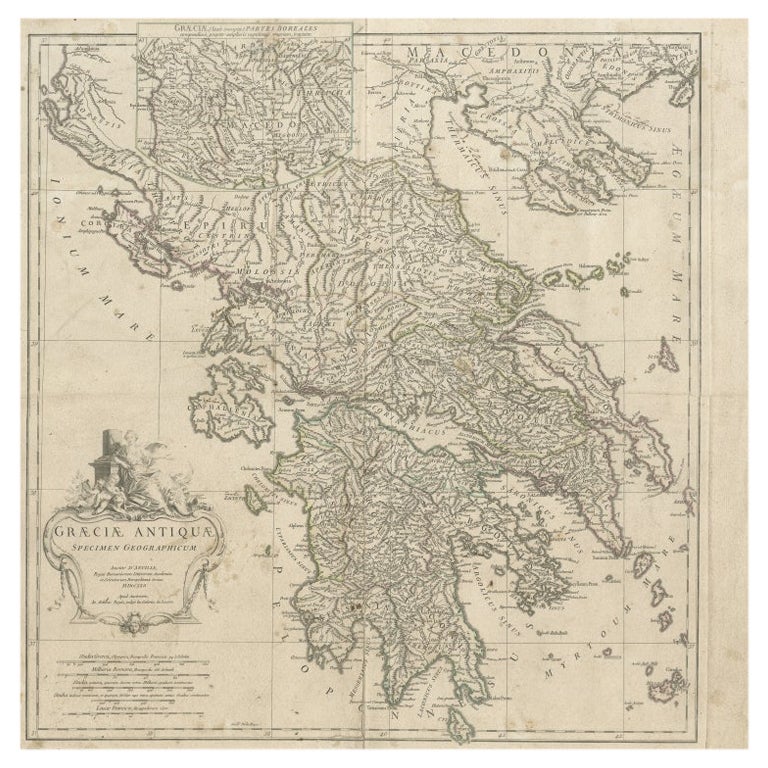
Large Scale Map of Greece with Inset Map of Macedonia, c.1786
Located in Langweer, NL
Antique map titled 'Graeciae Antiquae'. Large scale map of Greece, extends south to the island of Cythera. Inset map shows details of Macedonia. Publis...
Category
Antique 18th Century Maps
Materials
Paper
Antique Map of Greece, Albania, Macedonia and Parts of Turkey and Cyprus, c.1745
Located in Langweer, NL
Antique map titled 'Accurata Totius Archipelagi Et Graeciae Universae Tabula'.
Detailed map of Greece. Includes Albania, Macedonia and parts of Turkey and Cyprus. With compass rose...
Category
Antique 18th Century Maps
Materials
Paper

$814 Sale Price
20% Off
You May Also Like
Original Antique Map of Ancient Greece, Achaia, Corinth, 1786
Located in St Annes, Lancashire
Great map of Ancient Greece. Showing the region of Thessaly, including Mount Olympus
Drawn by J.D. Barbie Du Bocage
Copper plate engraving by P.F Tardieu
Original hand color...
Category
Antique 1780s French Other Maps
Materials
Paper

Map of Ancient Greece - Original Etching by Antonio Zatta - 1785
Located in Roma, IT
This Map of ancient Greek is an etching realized by Antonio Zatta in Venice in 1785.
The state of preservation of the artwork is good expect for the worn paper.
Mounted on a cardbo...
Category
1770s Landscape Prints
Materials
Etching

Map of Ancient Greece of Macedonia and... - Lithograph by Auguste Wahlen - 1844
Located in Roma, IT
Map of Ancient Greece of Macedonia and Thrace is a lithograph made by Auguste Wahlen in 1844.
Hand colored.
Good condition.
Bottom left is the original title "Carta della Grecia A...
Category
1840s Modern Figurative Prints
Materials
Lithograph

Greece, "Graeciae Antiquae"" A 17th Century Hand-colored Map by Sanson
By Nicolas Sanson
Located in Alamo, CA
This is an original 17th century hand colored copperplate engraved map of Greece entitled "Graeciae Antiquae Tabula Hanc Geographicam" by Nicolas d'Abbeville Sanson, engraved and pub...
Category
Antique Mid-17th Century French Maps
Materials
Paper

Map of Greece - Original Etching by Antonio Zatta - 18th Century
Located in Roma, IT
This Map of Greece is an etching realized by Antonio Zatta, Cartographer, publisher and typographer.
The state of preservation of the artwork is good except for the worn paper and t...
Category
1780s Figurative Prints
Materials
Etching

Original Antique Map of Ancient Greece- Boeotia, Thebes, 1787
Located in St Annes, Lancashire
Great map of Ancient Greece. Showing the region of Boeotia, including Thebes
Drawn by J.D. Barbie Du Bocage
Copper plate engraving by P.F T...
Category
Antique 1780s French Other Maps
Materials
Paper

More Ways To Browse
Greek Key Bar
Bavarian Antique
Antique Level Tool
Antique Gallia
Silver Over Copper
Vintage Barware Glasses
Coffee Table Black Italian Modern
Christofle America
Iranian Silk Rug Carpet
Poul Moller
Tables With Inlaid Wood
World War Table
Antonio Jacobsen
Ariston Chairs
Coffee Tables Europe
Marble Top Dining Tables
Nordiska Argentina
Pink And Black Rug