Items Similar to Antique Map of the Red Sea & Basse Thebaide with Monastery Plans, Egypt, 1777


Want more images or videos?
Request additional images or videos from the seller
1 of 10
Antique Map of the Red Sea & Basse Thebaide with Monastery Plans, Egypt, 1777
$584.94
£430.95
€490
CA$805.07
A$893.35
CHF 471.22
MX$10,905.88
NOK 5,961.85
SEK 5,583.75
DKK 3,729.91
About the Item
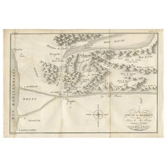
Antique Map of the Red Sea & Basse Thebaide with Monastery Plans, Egypt, 1777
This finely detailed 18th-century engraving depicts the coastal and inland geography of the Red Sea region of Egypt, with a particular focus on the Basse Thebaide area and its monastic settlements. The map’s main panel shows the Red Sea flanked by mountainous terrain, with numerous place names, natural features, and routes carefully engraved. The western shore includes parts of the Nile Valley, with towns, monasteries, and plains labelled, such as the Plaine de Bayoura and the Monastere de S. Antoine. The eastern shore features coastal landmarks and rugged highlands.
Two inset plans occupy the right side of the print. The first, Plan du Monastère de St. Antoine, shows the layout of this historic monastery in precise detail, complete with its church, gardens, wells, and surrounding defensive walls, as described by Coptic monks. The second inset, Plan du Monastère de St. Paul l’Hermite, offers a similar schematic of this equally significant religious site. Between the two plans is a small vignette of a local figure in traditional dress, labelled as a "Religieux copte de la Basse Thebaïde." The inclusion of these monastery plans alongside the regional map offers a valuable record of religious and cultural life in Egypt during the late 18th century.
Engraved in 1777, this map is a product of the Enlightenment’s fascination with geography, religion, and exploration. The precise line work and careful labelling reflect the cartographic standards of the period, and the combination of topographical mapping with architectural plans makes this a rare and compelling piece for collectors interested in both sacred architecture and Middle Eastern history.
Condition: Good for age. Minor toning, faint foxing and a waterstain along the margins. Vertical and horizontal folds as issued. Slight edge wear and minimal creasing, with strong, clean impressions and good paper strength.
Framing tips: This print would present beautifully in a dark wood or black frame to echo the engraved lines, paired with a cream or off-white mount to enhance the contrast and legibility of the fine details. A double mount with a thin black inner border would further highlight the intricate cartography and inset illustrations.
Technique: Engraving
Maker: Portier, France, 1777
- Dimensions:Height: 11.62 in (29.5 cm)Width: 16.93 in (43 cm)Depth: 0.01 in (0.2 mm)
- Materials and Techniques:Paper,Engraved
- Place of Origin:
- Period:
- Date of Manufacture:circa 1777
- Condition:Condition: Good for age. Minor toning, faint foxing and a waterstain along the margins. Vertical and horizontal folds as issued. Slight edge wear and minimal creasing, with strong, clean impressions and good paper strength.
- Seller Location:Langweer, NL
- Reference Number:Seller: BG-14078-411stDibs: LU3054346219862
About the Seller
5.0
Recognized Seller
These prestigious sellers are industry leaders and represent the highest echelon for item quality and design.
Platinum Seller
Premium sellers with a 4.7+ rating and 24-hour response times
Established in 2009
1stDibs seller since 2017
2,569 sales on 1stDibs
Typical response time: <1 hour
- ShippingRetrieving quote...Shipping from: Langweer, Netherlands
- Return Policy
Authenticity Guarantee
In the unlikely event there’s an issue with an item’s authenticity, contact us within 1 year for a full refund. DetailsMoney-Back Guarantee
If your item is not as described, is damaged in transit, or does not arrive, contact us within 7 days for a full refund. Details24-Hour Cancellation
You have a 24-hour grace period in which to reconsider your purchase, with no questions asked.Vetted Professional Sellers
Our world-class sellers must adhere to strict standards for service and quality, maintaining the integrity of our listings.Price-Match Guarantee
If you find that a seller listed the same item for a lower price elsewhere, we’ll match it.Trusted Global Delivery
Our best-in-class carrier network provides specialized shipping options worldwide, including custom delivery.More From This Seller
View AllAntique Map of the Route of the Hebrews – Egypt to the Red Sea, 1720
Located in Langweer, NL
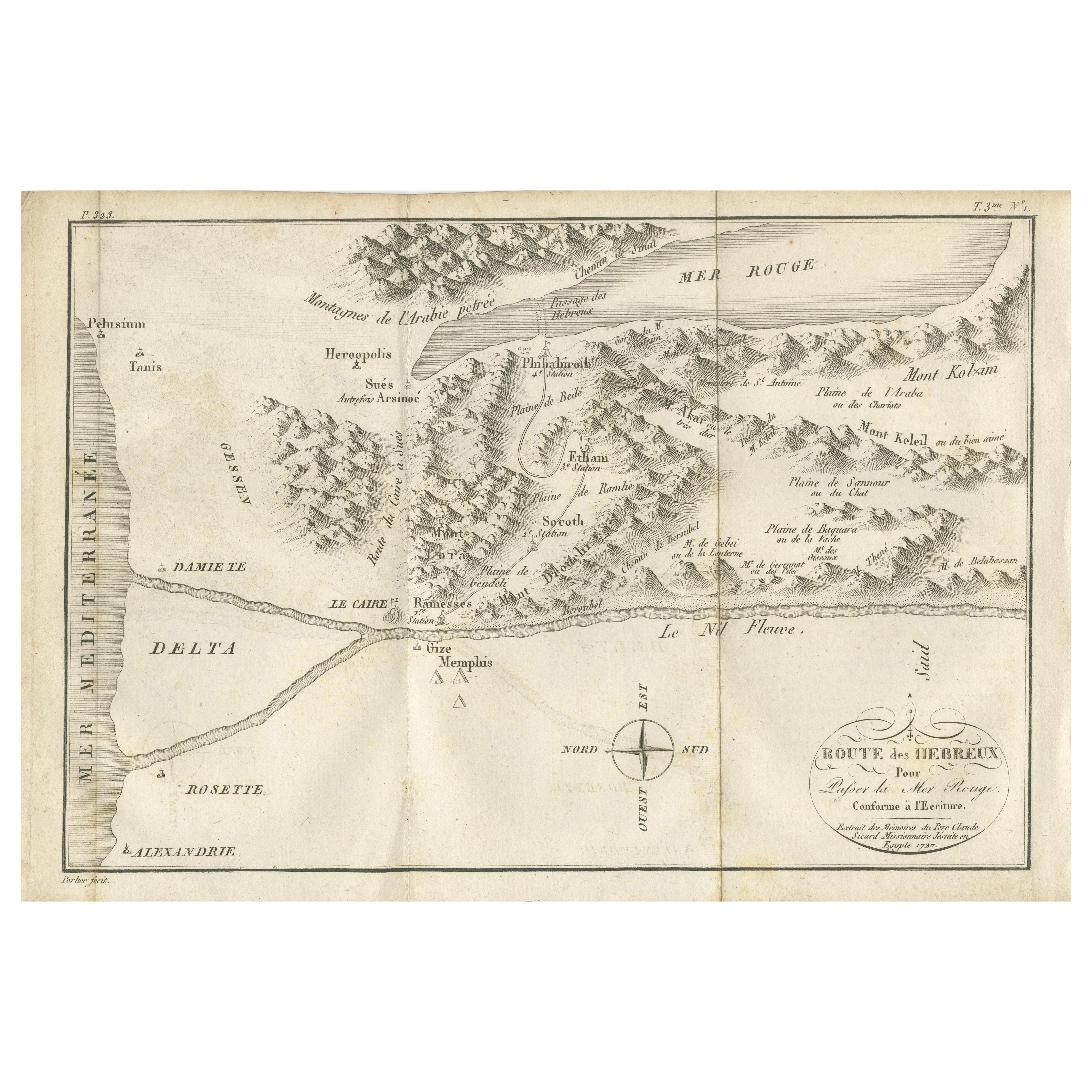
Map of the Route of the Hebrews – Egypt to the Red Sea, 1720
This finely engraved 18th-century map, titled Route des Hébreux pour passer la Mer Rouge, conforme à l’Écriture, traces ...
Category
Antique Early 18th Century French Maps
Materials
Paper
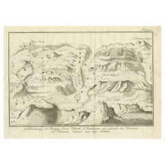
Mount Sinai & St. Catherine's – Antique Map of the Sinai Monasteries, 1776
Located in Langweer, NL
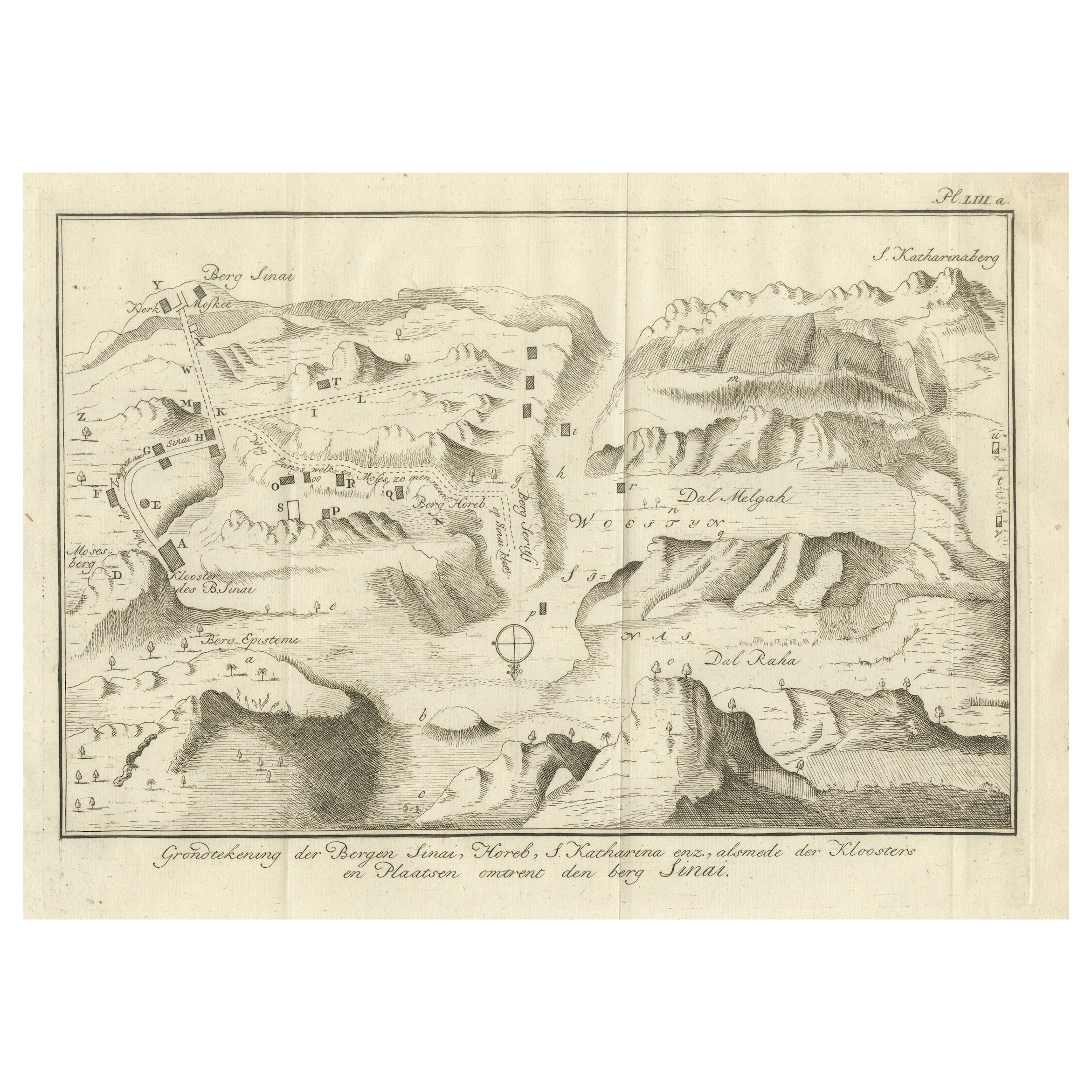
Mount Sinai & St. Catherine's – Antique Map of the Sinai Monasteries, 1776
Description:
This finely engraved antique map depicts the mountainous region of the Sinai Peninsula, focus...
Category
Antique Late 18th Century Dutch Maps
Materials
Paper
Antique Map of The Nile, Egypt and the Red Sea by Bachiene, 1765
Located in Langweer, NL
Antique map titled 'De XIde Landkaart verbeeldende Egypte en de Woestyne der Schelf-Zee (..).' Map of Biblical Egypt and the Red Sea. With title cartouche, compass rose and scale. Th...
Category
Antique 18th Century Maps
Materials
Paper

$167 Sale Price
20% Off
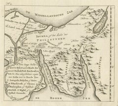
Antique Map of Edom, an Ancient Kingdom in Transjordan, 1773
Located in Langweer, NL
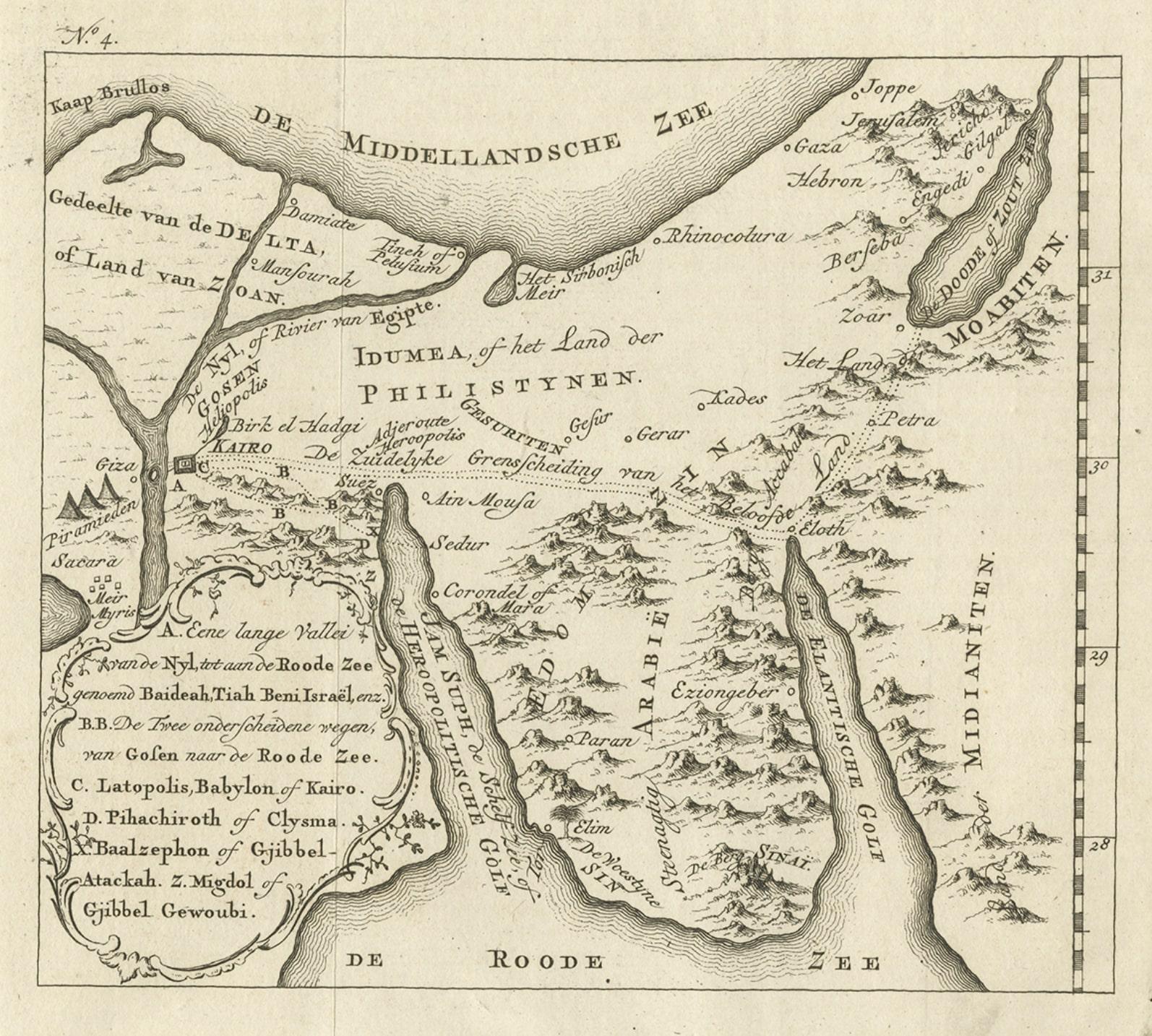
Antique print titled 'Idumea, of thet Land der Philistynen'. Old map of Edom, an ancient kingdom in Transjordan located between Moab to the northeast, the Arabah to the west and the ...
Category
Antique 18th Century Maps
Materials
Paper
$305 Sale Price
20% Off
Detailed Original Old Map of the Southern Region of the Kingdom of Algiers 1773
Located in Langweer, NL
Antique map titled 'Kaart van het Zuidelyk Gedeelte van het Ryk Algiers'.
Old map of the southern region of the Kingdom of Algiers, Algeria. Originates from the first Dutch edito...
Category
Antique 18th Century Maps
Materials
Paper

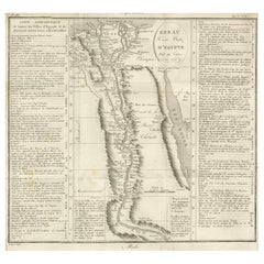
Antique Map of Egypt and the Nile Valley with City Index, 1715
Located in Langweer, NL
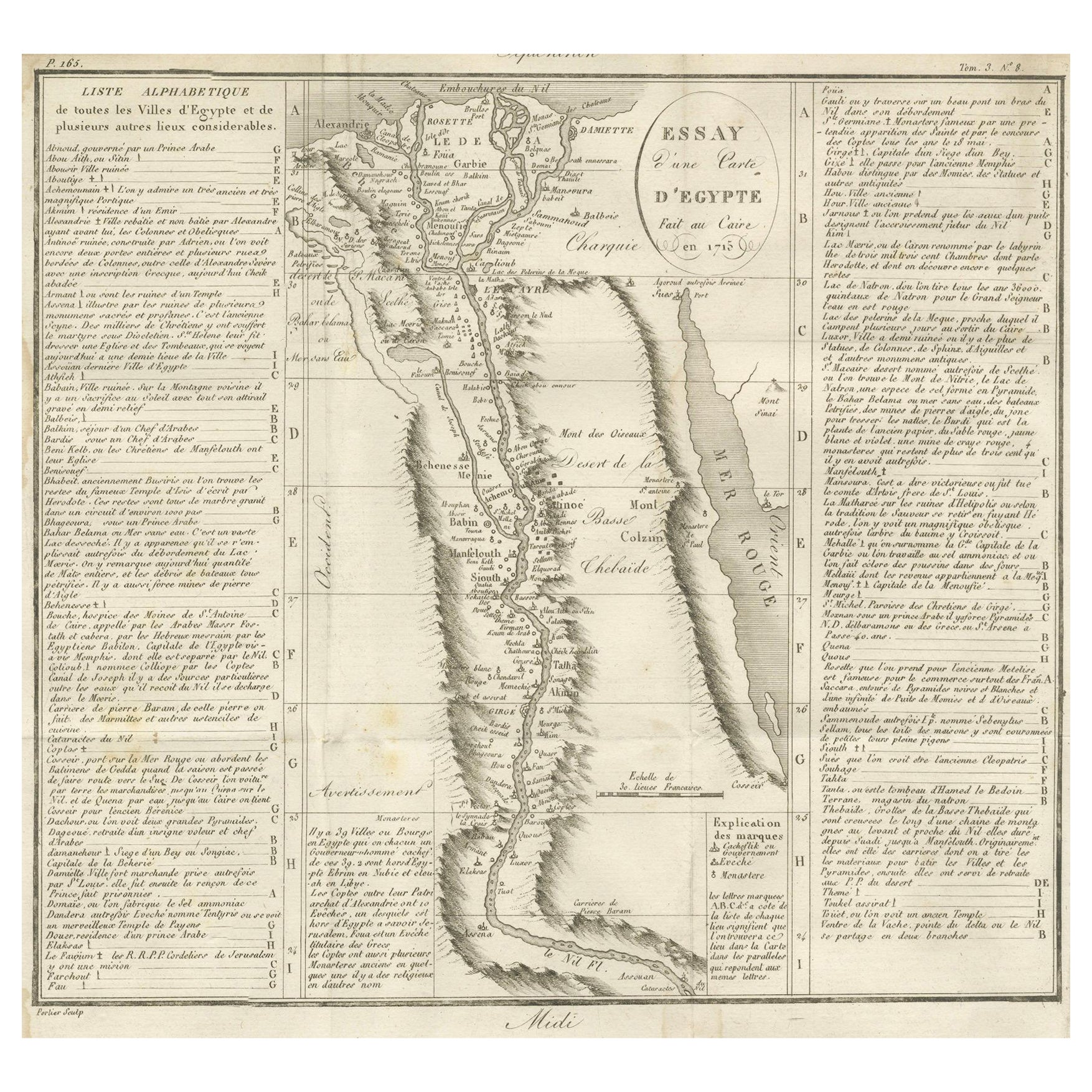
Antique map of Egypt, titled "Essay d'une Carte d'Égypte Fait au Caire en 1715".
This finely engraved map presents a detailed depiction of Egypt along the Nile River from the Medit...
Category
Antique Early 18th Century French Maps
Materials
Paper
You May Also Like
Map of Nubia and Abissinia - Original Etching by Antonio Zatta - 1784
Located in Roma, IT
This Map of Nubia and Abissinia is an etching realized by Antonio Zatta in Venice in 1784.
The state of preservation of the artwork is good expect for the worn paper with some littl...
Category
1770s Landscape Prints
Materials
Etching

Antique Map - Mar Di Athiopia - Etching by Johannes Janssonius - 1650s
By Johannes Janssonius
Located in Roma, IT
Antique Map - Mar Di Athiopia is an antique map realized in 1650 by Johannes Janssonius (1588-1664).
The Map is Hand-colored etching, with coeval watercolorang.
Good conditions wit...
Category
1650s Modern Figurative Prints
Materials
Etching

West Coast of Africa; Guinea & Sierra Leone: Bellin 18th Century Map
Located in Alamo, CA
This is a Jacques Bellin copper-plate map entitled "Partie de la Coste de Guinee Dupuis la Riviere de Sierra Leona Jusquau Cap das Palmas", depicting the coast of Guinea and Sierra L...
Category
1740s Old Masters Landscape Prints
Materials
Engraving

Antique French Map of Asia Including China Indoneseia India, 1783
Located in Amsterdam, Noord Holland
Very nice map of Asia. 1783 Dedie au Roy.
Additional information:
Country of Manufacturing: Europe
Period: 18th century Qing (1661 - 1912)
Condition: Overall Condition B (Good Used)...
Category
Antique 18th Century European Maps
Materials
Paper

$648 Sale Price
20% Off
Original Antique Map of Ancient Greece, Achaia, Corinth, 1786
Located in St Annes, Lancashire
Great map of Ancient Greece. Showing the region of Thessaly, including Mount Olympus
Drawn by J.D. Barbie Du Bocage
Copper plate engraving by P.F Tardieu
Original hand color...
Category
Antique 1780s French Other Maps
Materials
Paper

Mediterranean and Adriatic Seas: Original 18th Century Hand-colored Map by Bowen
Located in Alamo, CA
This is an original 18th century hand-colored map entitled "An Accurate Chart of The Mediterranean and Adriatic Sea's; with the Archipelago & Part of the Black Sea. Exhibiting all th...
Category
Mid-18th Century Old Masters Landscape Prints
Materials
Engraving
