Items Similar to Antique Map of the Route of the Hebrews – Egypt to the Red Sea, 1720


Want more images or videos?
Request additional images or videos from the seller
1 of 11
Antique Map of the Route of the Hebrews – Egypt to the Red Sea, 1720
$548.20
£405.98
€460
CA$755.26
A$839.72
CHF 442.16
MX$10,188.30
NOK 5,597.99
SEK 5,232.76
DKK 3,501.44
About the Item
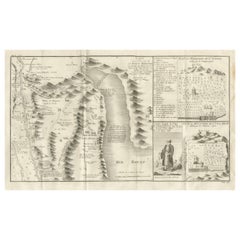
Map of the Route of the Hebrews – Egypt to the Red Sea, 1720
This finely engraved 18th-century map, titled Route des Hébreux pour passer la Mer Rouge, conforme à l’Écriture, traces the biblical journey of the Israelites from Egypt to the Red Sea, as recounted in the Book of Exodus. Drawn “Extrait des Mémoires du Père Claude Sicard, Missionnaire Apostolique en Égypte, 1720,” it reflects the research of Father Claude Sicard, a Jesuit missionary and one of the earliest modern scholars to explore and document biblical geography in Egypt.
The map extends from the Mediterranean coast (Alexandria, Rosetta, Damiette) to the Red Sea (Mer Rouge), with the Nile Delta prominently shown. Cities and ancient sites are labeled, including Memphis, Pelusium, Tanis, and Ramses, alongside biblical waypoints such as Succoth, Etham, and Pi-Hahiroth. Mountain ranges are depicted pictorially, with named peaks including Mont Kolzim, Mont Keleli, and Mont de Bekharsan. Plains, valleys, and routes are marked, such as the Plaine de Beid and Route de l’Arabie Pétrée.
The Passage des Hébreux is clearly indicated along the Red Sea’s western shore, aligning with contemporary 18th-century interpretations of the Exodus crossing site. The engraving also includes a decorative title cartouche in the lower right and a simple compass rose orienting the map north-south.
Marked “Tome 3, N° 4” and engraved by Porlier (Porlier Sculp.), this plate was part of a major Enlightenment-era historical and geographical series. It illustrates both the scholarly and religious interest in reconciling scripture with empirical observation, a hallmark of early modern biblical cartography.
Condition: Very good for age, with central folds as issued. Slight toning and minor foxing, mostly in margins. Strong plate impression with excellent preservation of engraved detail.
Framing tips: A dark wood or black frame with an off-white or cream mount will emphasize the antique character of the map. For thematic display, it pairs beautifully with other 18th-century biblical or Middle Eastern maps.
Technique: Copperplate engraving
Maker: Father Claude Sicard (source), engraved by A. Porlier, French school, c.1760
- Dimensions:Height: 7.88 in (20 cm)Width: 11.74 in (29.8 cm)Depth: 0.01 in (0.2 mm)
- Materials and Techniques:Paper,Engraved
- Place of Origin:
- Period:
- Date of Manufacture:circa 1720
- Condition:Condition: Very good for age, with central folds as issued. Slight toning and minor foxing, mostly in margins. Strong plate impression with excellent preservation of engraved detail.
- Seller Location:Langweer, NL
- Reference Number:Seller: BG-14078-291stDibs: LU3054346217952
About the Seller
5.0
Recognized Seller
These prestigious sellers are industry leaders and represent the highest echelon for item quality and design.
Platinum Seller
Premium sellers with a 4.7+ rating and 24-hour response times
Established in 2009
1stDibs seller since 2017
2,569 sales on 1stDibs
Typical response time: <1 hour
- ShippingRetrieving quote...Shipping from: Langweer, Netherlands
- Return Policy
Authenticity Guarantee
In the unlikely event there’s an issue with an item’s authenticity, contact us within 1 year for a full refund. DetailsMoney-Back Guarantee
If your item is not as described, is damaged in transit, or does not arrive, contact us within 7 days for a full refund. Details24-Hour Cancellation
You have a 24-hour grace period in which to reconsider your purchase, with no questions asked.Vetted Professional Sellers
Our world-class sellers must adhere to strict standards for service and quality, maintaining the integrity of our listings.Price-Match Guarantee
If you find that a seller listed the same item for a lower price elsewhere, we’ll match it.Trusted Global Delivery
Our best-in-class carrier network provides specialized shipping options worldwide, including custom delivery.More From This Seller
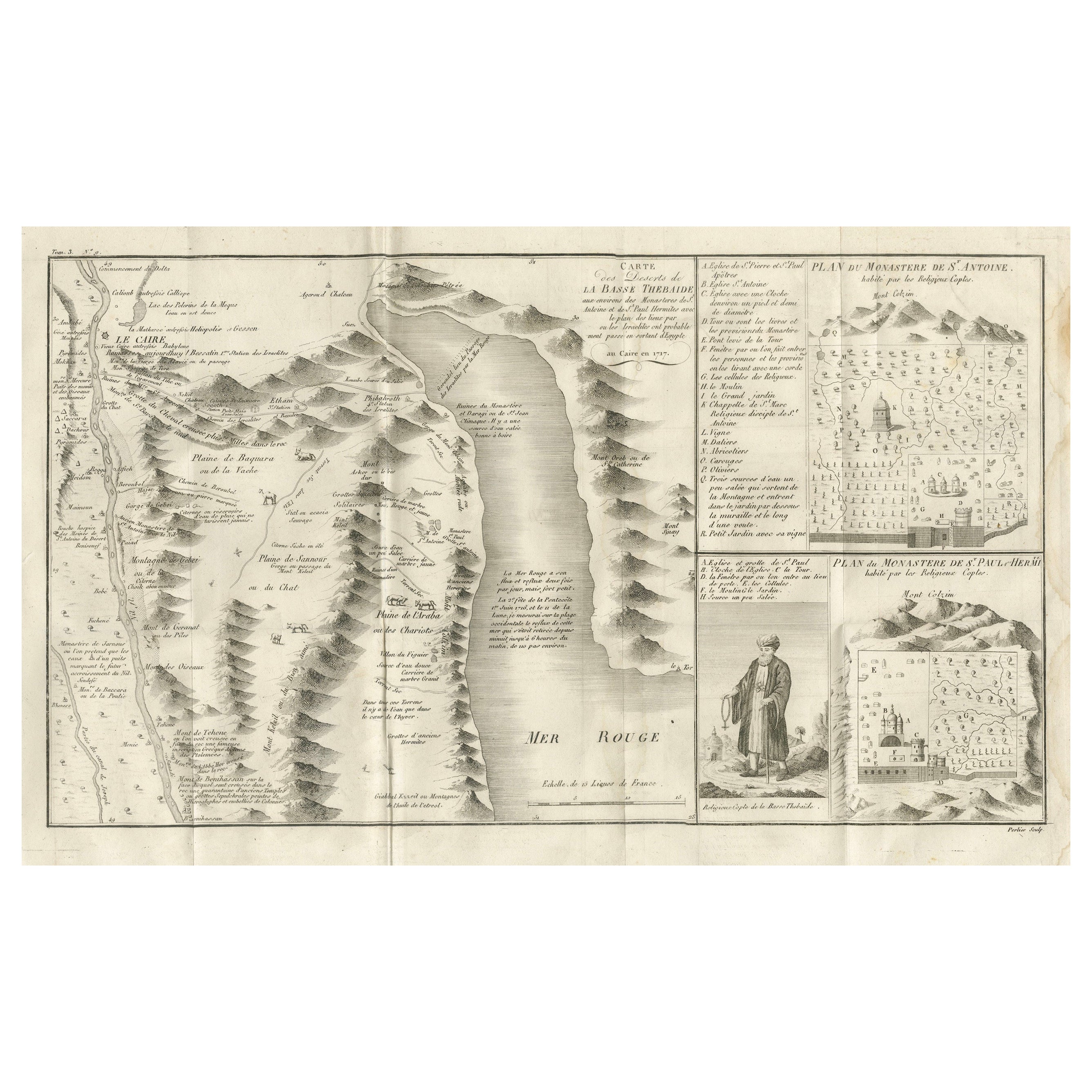
View AllAntique Map of the Red Sea & Basse Thebaide with Monastery Plans, Egypt, 1777
Located in Langweer, NL
Antique Map of the Red Sea & Basse Thebaide with Monastery Plans, Egypt, 1777
This finely detailed 18th-century engraving depicts the coastal and inland geography of the Red Sea reg...
Category
Antique Late 18th Century French Maps
Materials
Paper
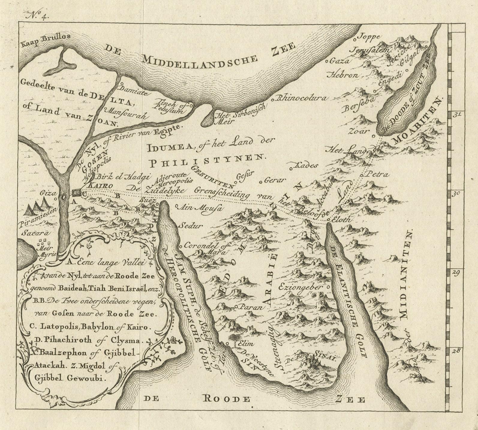
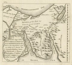
Antique Map of Edom, an Ancient Kingdom in Transjordan, 1773
Located in Langweer, NL
Antique print titled 'Idumea, of thet Land der Philistynen'. Old map of Edom, an ancient kingdom in Transjordan located between Moab to the northeast, the Arabah to the west and the ...
Category
Antique 18th Century Maps
Materials
Paper
$305 Sale Price
20% Off
Detailed Original Old Map of the Southern Region of the Kingdom of Algiers 1773
Located in Langweer, NL
Antique map titled 'Kaart van het Zuidelyk Gedeelte van het Ryk Algiers'.
Old map of the southern region of the Kingdom of Algiers, Algeria. Originates from the first Dutch edito...
Category
Antique 18th Century Maps
Materials
Paper

Antique Map of The Nile, Egypt and the Red Sea by Bachiene, 1765
Located in Langweer, NL
Antique map titled 'De XIde Landkaart verbeeldende Egypte en de Woestyne der Schelf-Zee (..).' Map of Biblical Egypt and the Red Sea. With title cartouche, compass rose and scale. Th...
Category
Antique 18th Century Maps
Materials
Paper

$166 Sale Price
20% Off
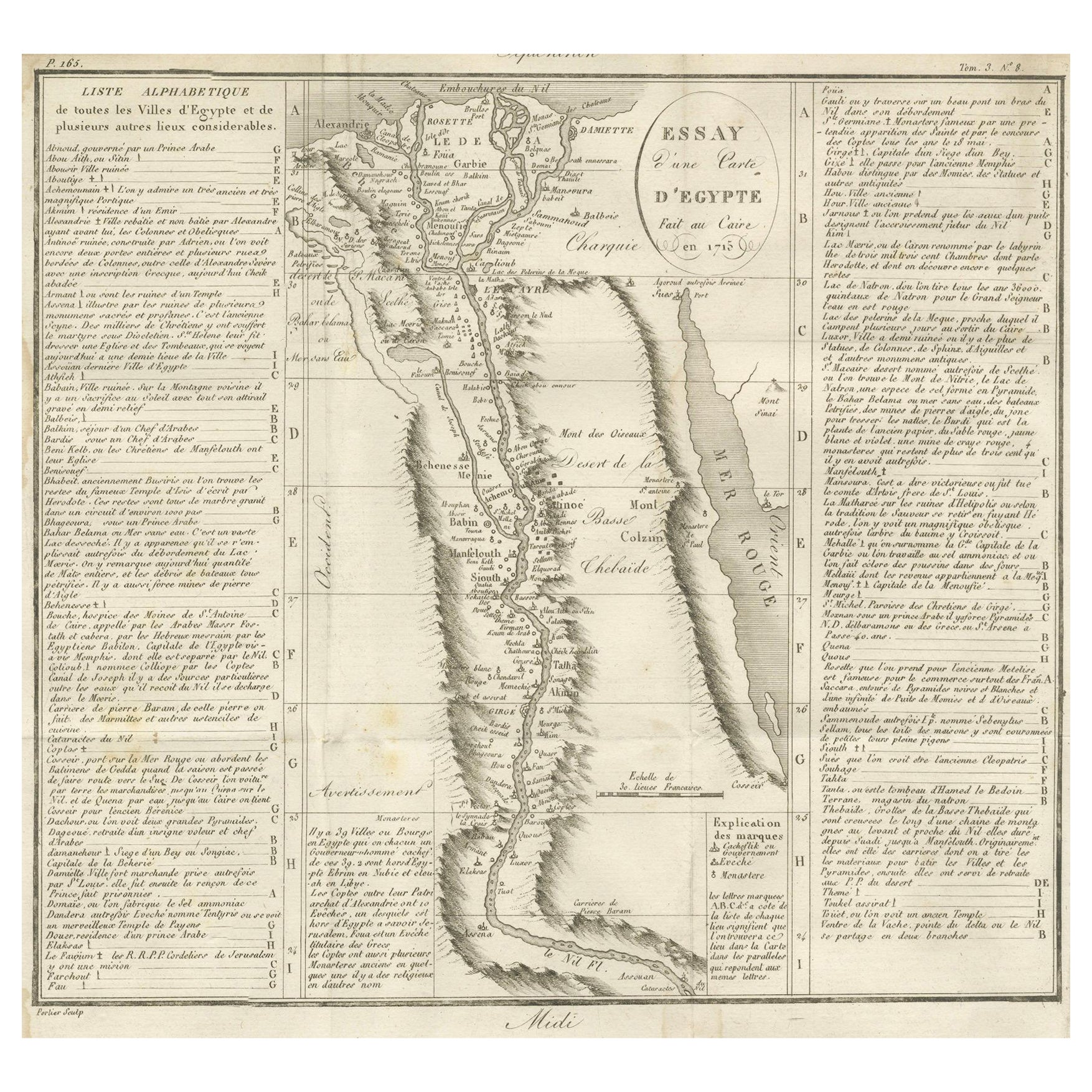
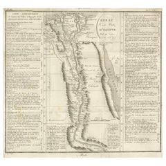
Antique Map of Egypt and the Nile Valley with City Index, 1715
Located in Langweer, NL
Antique map of Egypt, titled "Essay d'une Carte d'Égypte Fait au Caire en 1715".
This finely engraved map presents a detailed depiction of Egypt along the Nile River from the Medit...
Category
Antique Early 18th Century French Maps
Materials
Paper
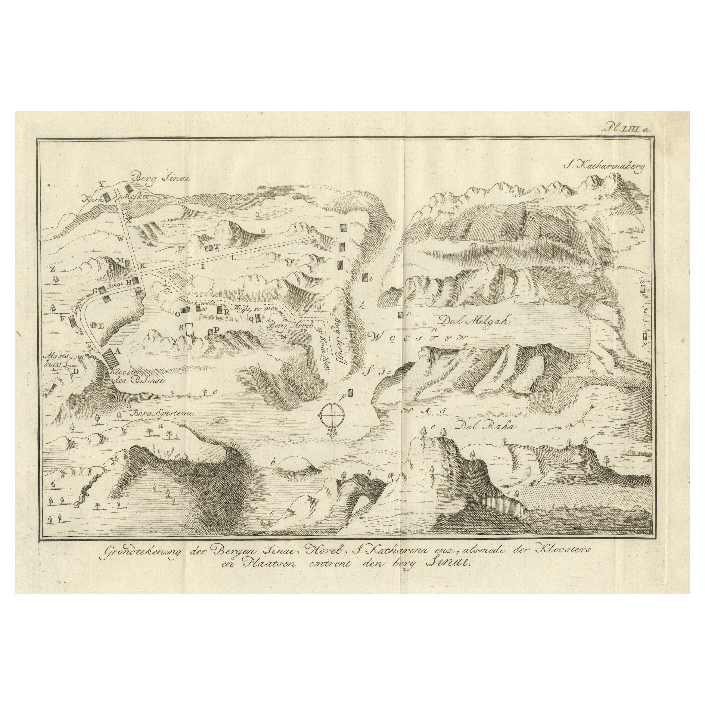
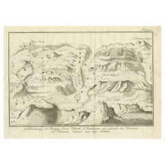
Mount Sinai & St. Catherine's – Antique Map of the Sinai Monasteries, 1776
Located in Langweer, NL
Mount Sinai & St. Catherine's – Antique Map of the Sinai Monasteries, 1776
Description:
This finely engraved antique map depicts the mountainous region of the Sinai Peninsula, focus...
Category
Antique Late 18th Century Dutch Maps
Materials
Paper
You May Also Like
Antique Map - Mar Di Athiopia - Etching by Johannes Janssonius - 1650s
By Johannes Janssonius
Located in Roma, IT
Antique Map - Mar Di Athiopia is an antique map realized in 1650 by Johannes Janssonius (1588-1664).
The Map is Hand-colored etching, with coeval watercolorang.
Good conditions wit...
Category
1650s Modern Figurative Prints
Materials
Etching

1714 Henri Chatelain "Nouvelle Carte Des Etatas Du Grand.Duc De Mos Moscovie Eur
Located in Norton, MA
A 1714 Henri Chatelain map, entitled
"Nouvelle Carte Des Etatas Du Grand Duc De Moscovie En Europe,"
Ricb001
Henri Abraham Chatelain (1684-1743) was a Huguenot pastor of Parisi...
Category
Antique Early 18th Century Dutch Maps
Materials
Paper

1633 Map "La Souverainete De Sedan Et De Raucourt, Et La Prevoste Ric0011
Located in Norton, MA
1653 map entitled
"La Souverainete de Sedan et de Raucourt, et la Prevoste de Doncheri,"
Ric0011
Description:
Lovely map centered on Sedan and Doncheri and the Meuze River fr...
Category
Antique 17th Century Dutch Maps
Materials
Paper

Southerlandia Map - Etching by Johannes Janssonius - 1650
By Johannes Janssonius
Located in Roma, IT
Southerlandia Map is an ancient map realized in 1650 by Johannes Janssonius (1588-1664).
The Map is Hand-colored etching, with coeval watercoloring.
Good conditions.
From Atlantis...
Category
1650s Modern Figurative Prints
Materials
Etching

Mediterranean and Adriatic Seas: Original 18th Century Hand-colored Map by Bowen
Located in Alamo, CA
This is an original 18th century hand-colored map entitled "An Accurate Chart of The Mediterranean and Adriatic Sea's; with the Archipelago & Part of the Black Sea. Exhibiting all th...
Category
Mid-18th Century Old Masters Landscape Prints
Materials
Engraving

Map of Mar Del Nort - Etching by Johannes Janssonius - 1650s
By Johannes Janssonius
Located in Roma, IT
Antique Map -Mar Del Nort is an antique map realized in 1650 by Johannes Janssonius (1588-1664).
The Map is Hand-colored etching, with coeval watercolorang.
Good conditions with sl...
Category
1650s Modern Figurative Prints
Materials
Etching
