Items Similar to Antique Map of Scandinavia 1857 – Sweden & Norway in Detail


Video Loading
Want more images or videos?
Request additional images or videos from the seller
1 of 12
Antique Map of Scandinavia 1857 – Sweden & Norway in Detail
$400.73
£301.83
€340
CA$552.63
A$620.85
CHF 324.40
MX$7,577.77
NOK 4,118.88
SEK 3,877.05
DKK 2,587.95
About the Item
Sweden and Norway Map – Stieler Atlas Engraving, 1858
This fine antique map titled Schweden und Norwegen (Sweden and Norway) was published in 1858 by Justus Perthes of Gotha and drawn by F. v. Stülpnagel for the influential Stieler’s Hand-Atlas. It depicts the Scandinavian Peninsula in remarkable detail, from Denmark in the south to the Arctic coast and the "Eismeer" (Ice Sea) in the north.
The map offers a vivid topographical rendering of Sweden and Norway’s mountainous terrain, fjords, and inland regions, with political boundaries outlined in original hand color. Norwegian coastal towns like Bergen, Trondheim, and Tromsø are clearly marked, alongside Swedish cities including Stockholm, Gothenburg, and Uppsala. The southern tip of Finland is also partially shown, with Helsinki and Åbo labelled, and an inset map details the Stockholm archipelago and surrounding region.
At the time of this map's creation, Sweden and Norway were united under a single monarch (from 1814 to 1905), and the map reflects that political arrangement. Key postal routes, railways, and ferry crossings are also indicated, demonstrating the map’s practical use as a geographic and administrative reference in the mid-19th century.
Drawn with precision and engraved on copperplate, this map is an excellent example of the cartographic craftsmanship of the Justus Perthes publishing house. The ornate title cartouche and fine engraving of terrain and coastlines make it both historically significant and visually appealing.
Condition report: Very good condition with strong plate mark, minor toning around the edges, and no tears or repairs. Paper is clean and crisp, with only minimal age-related wear.
Framing tips: Best presented in a dark walnut or Scandinavian birchwood frame with a wide ivory or light grey mat. The vertical orientation lends itself well to narrow walls or between windows. Ideal for collectors of Nordic history or decorative antique cartography.
Technique: Copperplate engraving with original hand colouring
Maker: F. v. Stülpnagel, Justus Perthes, Gotha, 1858
- Dimensions:Height: 17.88 in (45.4 cm)Width: 14.77 in (37.5 cm)Depth: 0.01 in (0.2 mm)
- Materials and Techniques:Paper,Engraved
- Place of Origin:
- Period:
- Date of Manufacture:1857
- Condition:Condition report: Very good condition with strong plate mark, minor toning around the edges, and no tears or repairs. Paper is clean and crisp, with only minimal age-related wear.
- Seller Location:Langweer, NL
- Reference Number:Seller: BG-05552-241stDibs: LU3054346100392
About the Seller
5.0
Recognized Seller
These prestigious sellers are industry leaders and represent the highest echelon for item quality and design.
Platinum Seller
Premium sellers with a 4.7+ rating and 24-hour response times
Established in 2009
1stDibs seller since 2017
2,533 sales on 1stDibs
Typical response time: <1 hour
- ShippingRetrieving quote...Shipping from: Langweer, Netherlands
- Return Policy
Authenticity Guarantee
In the unlikely event there’s an issue with an item’s authenticity, contact us within 1 year for a full refund. DetailsMoney-Back Guarantee
If your item is not as described, is damaged in transit, or does not arrive, contact us within 7 days for a full refund. Details24-Hour Cancellation
You have a 24-hour grace period in which to reconsider your purchase, with no questions asked.Vetted Professional Sellers
Our world-class sellers must adhere to strict standards for service and quality, maintaining the integrity of our listings.Price-Match Guarantee
If you find that a seller listed the same item for a lower price elsewhere, we’ll match it.Trusted Global Delivery
Our best-in-class carrier network provides specialized shipping options worldwide, including custom delivery.More From This Seller
View AllSweden & Norway – Antique Map of Scandinavia with Stockholm Inset, 1865
Located in Langweer, NL
Sweden & Norway – Antique Map of Scandinavia with Stockholm Inset, 1865
This finely detailed antique map titled Sweden & Norway (Scandinavia) offers a comprehensive 19th-century vie...
Category
Antique Mid-19th Century English Maps
Materials
Paper

$259 Sale Price
20% Off
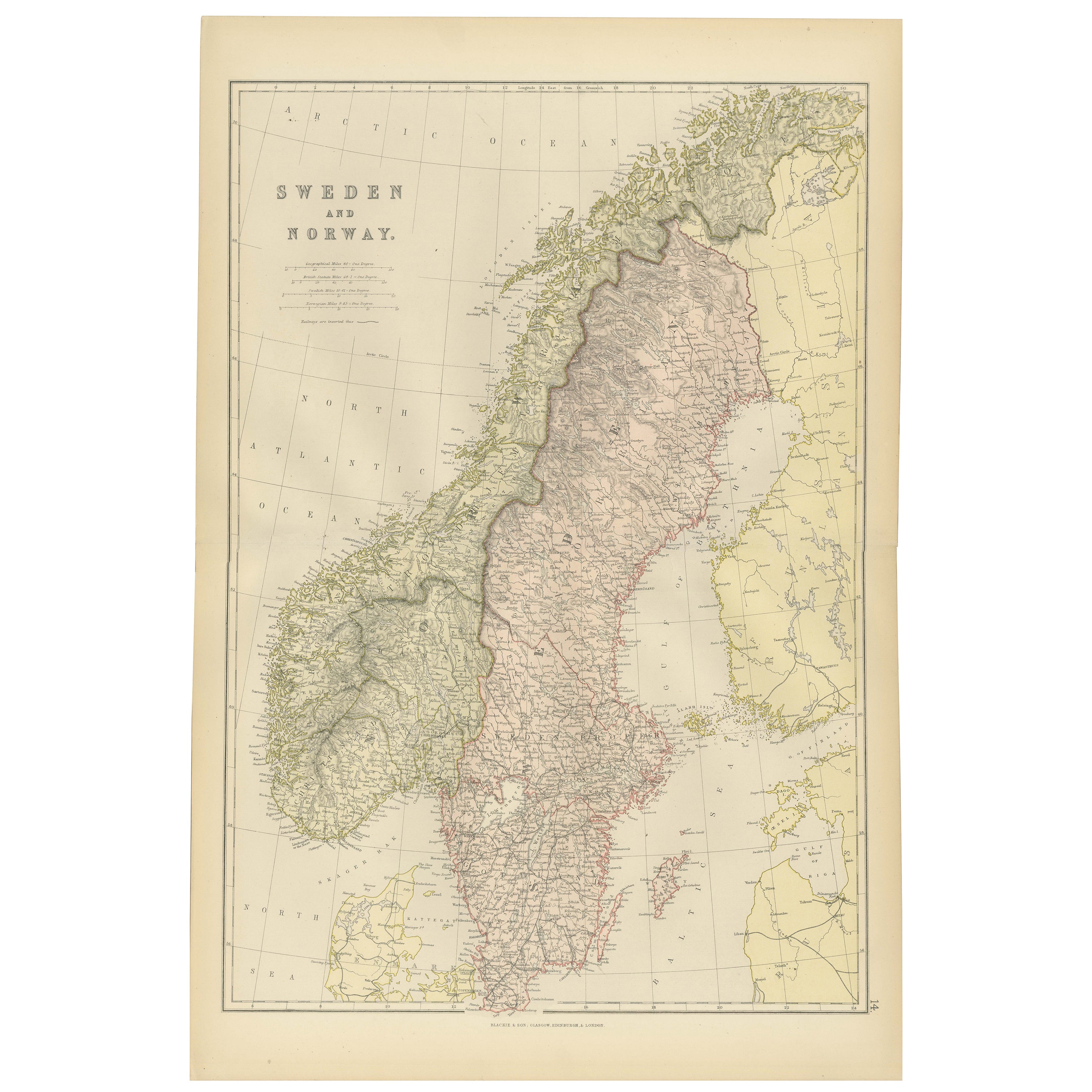
Antique Map of Sweden and Norway by W. G. Blackie, 1859
Located in Langweer, NL
Antique map titled 'Sweden and Norway'. Original antique map of Sweden and Norway. This map originates from ‘The Imperial Atlas of Modern Geography’. Published by W. G. Blackie, 1859.
Category
Antique Mid-19th Century Maps
Materials
Paper

$235 Sale Price
20% Off
1882 Map of Sweden and Norway Highlighting Geographical and Political Features
Located in Langweer, NL
This 1882 map of Sweden and Norway, published by Blackie and Son as part of the 'Comprehensive Atlas and Geography of the World,' provides a detailed depiction of the Scandinavian Pe...
Category
Antique 1880s Maps
Materials
Paper

Antique Map of Sweden and Norway by Petri, c.1873
Located in Langweer, NL
Antique map titled 'Zweden en Noorwegen'. Old map depicting Sweden and Norway. This map originates from 'School-Atlas van alle Deelen der Aarde'. Artists and Engravers: Published by ...
Category
Antique 19th Century Maps
Materials
Paper

$110 Sale Price
20% Off
Antique Map of Sweden and Norway by Petri, 1852
Located in Langweer, NL
Antique map titled 'Zweden en Noorwegen'. Map of Sweden and Norway. This map originates from 'School-Atlas van alle deelen der Aarde' by Otto Petri. Artists...
Category
Antique 19th Century Maps
Materials
Paper

$113 Sale Price
20% Off
Antique Map of Sweden & Norway, 1903, with Intricate Topographical Detail
Located in Langweer, NL
Title: Antique Map of Sweden & Norway, 1903, with Intricate Topographical Detail
Description:
This antique map, titled "Sweden & Norway (Scandinavia)," was engraved and published in...
Category
Early 20th Century Maps
Materials
Paper

You May Also Like
Original Antique Map of Sweden, Engraved by Barlow, 1806
Located in St Annes, Lancashire
Great map of Sweden
Copper-plate engraving by Barlow
Published by Brightly & Kinnersly, Bungay, Suffolk. 1806
Unframed.
Category
Antique Early 1800s English Maps
Materials
Paper

Large Original Vintage Map of Sweden and Norway circa 1920
Located in St Annes, Lancashire
Great map of Sweden and Norway
Original color. Good condition
Published by Alexander Gross
Unframed.
Category
Vintage 1920s English Victorian Maps
Materials
Paper

Ancient Map of Denmark and Sweden - Original Etching - 19th Century
By Giuseppe Malandrino
Located in Roma, IT
This Map of Denmark and Sweden is an etching realized by an anonymous artist.
The state of preservation of the artwork is good with some small diffused stains.
Sheet dimension: 27x...
Category
Late 19th Century Modern Figurative Prints
Materials
Etching

Denmark. Century Atlas antique vintage map
Located in Melbourne, Victoria
'The Century Atlas. Denmark'
Original antique map, 1903.
Inset maps of 'Faroe Islands', 'Iceland' and 'Copenhagen'.
Central fold as issued. Map name and number printed on the reve...
Category
Early 20th Century Victorian More Prints
Materials
Lithograph

Sweden and Adjacent Portions of Scandinavia: A Hand-colored 18th C. Homann Map
By Johann Baptist Homann
Located in Alamo, CA
This hand-colored copper-plate map of Sweden and adjacent portions of Scandinavia entitled "Regni Sueciae in Omnes suas Subjacentes Provincias accurate divisi Tabula Generalis" was c...
Category
Early 18th Century Old Masters Landscape Prints
Materials
Engraving

Russia in Europe with Poland and Finland. Century Atlas antique vintage map
Located in Melbourne, Victoria
'The Century Atlas. Russia in Europe with Poland and Finland'
Original antique map, 1903.
Central fold as issued. Map name and number printed on the reverse corners.
Sheet 40cm by ...
Category
Early 20th Century Victorian More Prints
Materials
Lithograph
