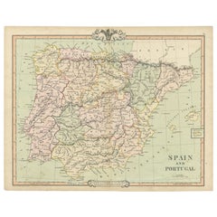
Items Similar to Antique Map of Spain and Portugal – Hand-Colored Engraving by Stülpnagel, 1857


Video Loading
Want more images or videos?
Request additional images or videos from the seller
1 of 12
Antique Map of Spain and Portugal – Hand-Colored Engraving by Stülpnagel, 1857
$400.73
£301.83
€340
CA$552.63
A$620.85
CHF 324.40
MX$7,577.77
NOK 4,118.88
SEK 3,877.05
DKK 2,587.95
About the Item
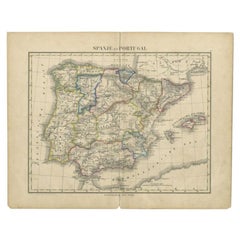
Antique Map of Spain and Portugal – Hand-Colored Engraving by Stülpnagel, 1857
Fine 19th-century engraved map of the Iberian Peninsula titled "Spanien und Portugal", designed by F. von Stülpnagel and published by Justus Perthes in Gotha in 1857. This detailed and beautifully hand-colored map provides an accurate depiction of Spain and Portugal during a period of complex internal divisions and regional identities.
The map covers the entire Iberian Peninsula, including mainland Spain and Portugal, as well as the Balearic Islands in the Mediterranean and a portion of North Africa at the southern edge. Political boundaries between the provinces are delicately outlined in hand-applied colors, with careful attention to natural features such as rivers, mountain ranges, and coastlines. Major cities—such as Madrid, Lisbon, Seville, Barcelona, and Valencia—are clearly labeled, alongside hundreds of smaller towns and regional centers.
A classification of the Spanish administrative divisions is provided in the lower right corner, identifying regions such as Castile, Andalusia, Aragon, Catalonia, Galicia, and the Basque Provinces. The map also includes a mileage scale and inset longitude grid referencing the Ferro meridian.
The topographical engraving is particularly fine, with shaded relief indicating the mountainous terrain of the Pyrenees and the central Meseta. The clarity and density of place names underscore the scholarly precision of the cartographer, making this map valuable not only for decorative purposes but also for historical research.
Produced by the renowned publishing house Justus Perthes and the distinguished German geographer Stülpnagel, this map is a prime example of 19th-century German cartography and remains a striking representation of Iberian geography before the rise of modern infrastructure.
Condition report:
Very good condition. Minor age-related toning at the edges. Hand-coloring remains vivid and well-preserved. No tears or repairs. Please refer to the image for visual confirmation.
Framing tips:
Pair this map with a walnut or dark oak frame and a pale cream or soft sand-colored mat. A narrow gold or olive inner lining may enhance the green-toned outlines. Ideal for a study, hallway, or alongside other antique European maps.
Technique: Engraving with original hand-coloring
Maker: F. von Stülpnagel, published by Justus Perthes, Gotha, 1857
- Dimensions:Height: 14.77 in (37.5 cm)Width: 17.88 in (45.4 cm)Depth: 0.01 in (0.2 mm)
- Materials and Techniques:Paper,Engraved
- Place of Origin:
- Period:
- Date of Manufacture:1858
- Condition:Very good condition. Minor age-related toning at the edges. Hand-coloring remains vivid and well-preserved. No tears or repairs. Please refer to the image for visual confirmation.
- Seller Location:Langweer, NL
- Reference Number:Seller: BG-05552-131stDibs: LU3054346116052
About the Seller
5.0
Recognized Seller
These prestigious sellers are industry leaders and represent the highest echelon for item quality and design.
Platinum Seller
Premium sellers with a 4.7+ rating and 24-hour response times
Established in 2009
1stDibs seller since 2017
2,533 sales on 1stDibs
Typical response time: <1 hour
- ShippingRetrieving quote...Shipping from: Langweer, Netherlands
- Return Policy
Authenticity Guarantee
In the unlikely event there’s an issue with an item’s authenticity, contact us within 1 year for a full refund. DetailsMoney-Back Guarantee
If your item is not as described, is damaged in transit, or does not arrive, contact us within 7 days for a full refund. Details24-Hour Cancellation
You have a 24-hour grace period in which to reconsider your purchase, with no questions asked.Vetted Professional Sellers
Our world-class sellers must adhere to strict standards for service and quality, maintaining the integrity of our listings.Price-Match Guarantee
If you find that a seller listed the same item for a lower price elsewhere, we’ll match it.Trusted Global Delivery
Our best-in-class carrier network provides specialized shipping options worldwide, including custom delivery.More From This Seller
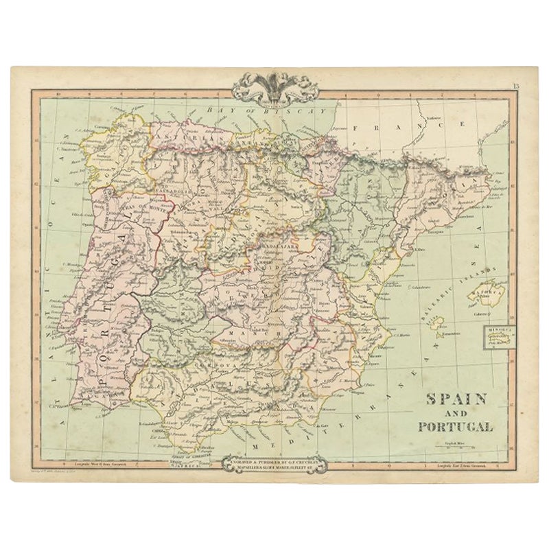
View AllAntique Map of Spain and Portugal by A & C. Black, 1870
Located in Langweer, NL
Antique map titled 'Spain and Portugal'. Original antique map of General map of Spain and Portugal with inset map of Gibraltar. This map originates from ‘Black's General Atlas of The...
Category
Antique Late 19th Century Maps
Materials
Paper

$194 Sale Price
40% Off
Antique Map of Spain and Portugal by Cruchley, 1854
Located in Langweer, NL
"Antique map of Spain and Portugal. Also depicts the islands Formentera, Ibiza, Mallorca and Minorca. Artists and Engravers: Engraved and publishe...
Category
Antique 19th Century Maps
Materials
Paper
$113 Sale Price
20% Off
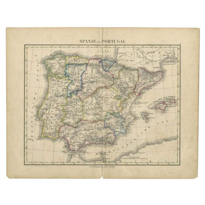
Antique Map of Spain and Portugal by Petri, c.1873
Located in Langweer, NL
Antique map titled 'Spanje en Portugal'. Old map depicting Spain and Portugal. This map originates from 'School-Atlas van alle Deelen der Aarde'. Artists and Engravers: Published by ...
Category
Antique 19th Century Maps
Materials
Paper
$91 Sale Price
20% Off
Antique Map of Spain and Portugal by Levasseur, '1875'
Located in Langweer, NL
Antique map titled 'Carte générale de l'Espagne et du Portugal (..)'. Large map of Spain and Portugal. This map originates from 'Atlas de Géographie Moder...
Category
Antique Late 19th Century Maps
Materials
Paper

$354 Sale Price
40% Off
Antique Map of Spain and Portugal by Petri, 1852
Located in Langweer, NL
Antique map titled 'Spanje en Portugal'. Map of Spain and Portugal. This map originates from 'School-Atlas van alle deelen der Aarde' by Otto Petri. Artists and Engravers: Published ...
Category
Antique 19th Century Maps
Materials
Paper
$113 Sale Price
20% Off
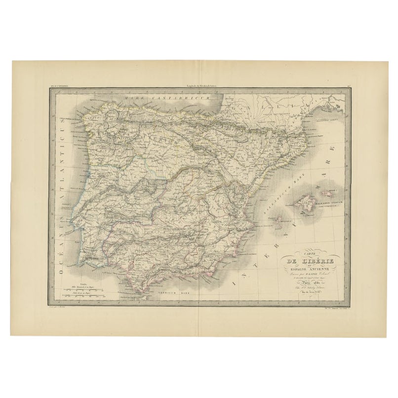
Antique Map of Iberia or the Iberian Peninsula with Portugal and Spain, 1842
Located in Langweer, NL
Antique map titled 'Carte de l'Ibérie ou Espagne Ancienne'. Map of Iberia, or the Iberian Peninsula. This map originates from 'Atlas universel de géographie ancienne et moderne (..)'...
Category
Antique 19th Century Maps
Materials
Paper
$359 Sale Price
20% Off
You May Also Like
Spain and Portugal: A Hand-colored 17th/18th Century Map by Visscher
By Nicolaus Visscher
Located in Alamo, CA
This is an early 18th century map of Spain and Portugal, with attractive original hand-coloring, entitled "Hispaniae et Portugalliae Regna per Nicolaum Visscher cum Privilegio Ordinum Hollandiae et Westfrisiae" first published by Nicolaes Visscher II (1649-1702) in 1688, and later re-published from Visscher's original copper plate by Peter Schenk, Junior in Amsterdam in 1725. The cartouche in the right lower corner depicts a coat of arms representing one combined kingdom of Spain and Portugal before their break-up. Putti hold up the coat-of-arms of Phillip II on the right and a queen reaches for it on the left. There is a scale cartouche in the lower left corner surmounted by two putti and a wheel. This is an outstanding depiction of the Iberian peninsula, showing Spain and Portugal and Balearic Islands. The map includes portions of North Africa and the Strait of Gibralter.
This copperplate engraved map is presented in a cream-colored mat. It is printed on fine chain-linked, laid paper. The mat measures 26.5" high by 30" wide and the sheet measures 21.75" high by 26.375" wide. There is a central fold, as issued. The lower portion of the fold is reinforced on the verso. There is a small paper defect at the lower edge of the fold and another at the edge of the right corner, as well as a few small tears along the lower edge; none affecting the map and all covered by the mat. There are a few small faint spots in the upper margin and on the left. The map is otherwise in very good condition.
The Visscher family were one of the great art and cartographic printing families of the 17th century. Begun by Claes Jansz Visscher...
Category
Late 17th Century Other Art Style Landscape Prints
Materials
Engraving

Map of Spain and Portugal - Original Etching - Late 19th Century
Located in Roma, IT
This Map of Spain and Portugal is an etching realized by an anonymous artist.
The state of preservation of the artwork is good with some small diffused stains.
Sheet dimension: 28...
Category
Late 19th Century Modern Figurative Prints
Materials
Etching

Map of Spain and Portugal - Etching by Pierre François Tardieu - 1837
Located in Roma, IT
Map of Spain and Portugal is an Etching realized by Pierre François Tardieu in 1837.
Good conditions.
The artwork is realized in a well-balanced composition. the artwork and belong...
Category
1830s Modern Figurative Prints
Materials
Lithograph

Original Antique Map of Spain and Portugal, circa 1790
Located in St Annes, Lancashire
Super map of Spain and Portugal
Copper plate engraving by A. Bell
Published, circa 1790.
Unframed.
Category
Antique 1790s English Other Maps
Materials
Paper

Large Original Vintage Map of Spain, circa 1920
Located in St Annes, Lancashire
Great map of Spain
Original color.
Good condition
Published by Alexander Gross
Unframed.
Category
Vintage 1920s English Maps
Materials
Paper

After Johann B. Homann (1664-1724) - 19th C, General Map of Spain and Portugal
Located in Corsham, GB
General map of Spain and Portugal divided into its current provinces by D.T. Lopez, newly drawn by F. L. G. in Nuremberg at the Heret of Homann, 1782. A double-page engraved map with...
Category
19th Century More Prints
Materials
Engraving
