Items Similar to Antique Map of Tonkin and Hainan Island – 18th Century French Engraving


Want more images or videos?
Request additional images or videos from the seller
1 of 10
Antique Map of Tonkin and Hainan Island – 18th Century French Engraving
$580.77
£432.37
€490
CA$800.21
A$891.03
CHF 471.20
MX$10,843.28
NOK 5,939.54
SEK 5,595.92
DKK 3,730.14
About the Item
Antique Map of Tonkin and Hainan Island – 18th Century French Engraving
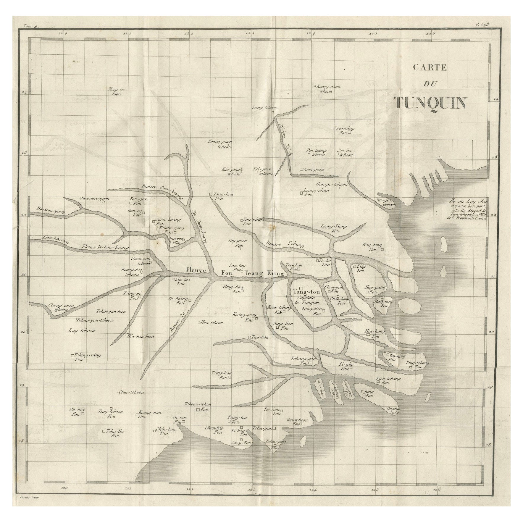
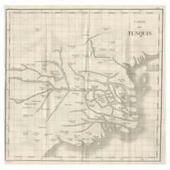
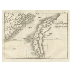
This is the “5me Carte du Tunquin,” an antique engraved map depicting the northern coastal region of modern-day Vietnam, southern China, and the island of Hainan. The map shows detailed waterways, settlements, and geographic features along the Gulf of Tonkin, including the “Province de Canton” to the north and “Partie de l’Isle de Haynan” to the east. Coastal towns, rivers, and islands are named in French transliterations of local names, such as Fleuve Ton Leuang and Koue-hoe. The chart is laid out with a fine coordinate grid, reflecting 18th-century cartographic precision and French mapping conventions.
Produced during a period of heightened European interest in Southeast Asia, this map would have been part of a larger geographic and missionary record, possibly associated with Jesuit explorations and reporting from the region. Such maps were important in disseminating geographic knowledge to European audiences and documenting key coastal and inland trade routes. The style, typography, and engraving technique suggest mid-to-late 18th century origins, with clean hachuring to indicate relief and stippling for coastal waters.
Condition: Very good for its age, with a visible central fold as issued, minor handling marks, and some light toning to the edges. Paper remains strong, and all engraved lines are clear and sharp. No significant tears or losses.
Framing tips: This map would look excellent framed in a dark wooden or black frame to contrast with the pale paper, with a cream or light ivory mount to highlight the engraved details. A UV-protective glass is recommended to preserve the paper from further toning.
Technique: Engraving
Maker: Unattributed (French school), 18th century
- Dimensions:Height: 12.21 in (31 cm)Width: 18.12 in (46 cm)Depth: 0.01 in (0.2 mm)
- Materials and Techniques:Paper,Engraved
- Place of Origin:
- Period:
- Date of Manufacture:circa 1780
- Condition:Condition: Very good for its age, with a visible central fold as issued, minor handling marks, and some light toning to the edges. Paper remains strong, and all engraved lines are clear and sharp. No significant tears or losses.
- Seller Location:Langweer, NL
- Reference Number:Seller: BG-14078-441stDibs: LU3054346220182
About the Seller
5.0
Recognized Seller
These prestigious sellers are industry leaders and represent the highest echelon for item quality and design.
Platinum Seller
Premium sellers with a 4.7+ rating and 24-hour response times
Established in 2009
1stDibs seller since 2017
2,569 sales on 1stDibs
Typical response time: <1 hour
- ShippingRetrieving quote...Shipping from: Langweer, Netherlands
- Return Policy
Authenticity Guarantee
In the unlikely event there’s an issue with an item’s authenticity, contact us within 1 year for a full refund. DetailsMoney-Back Guarantee
If your item is not as described, is damaged in transit, or does not arrive, contact us within 7 days for a full refund. Details24-Hour Cancellation
You have a 24-hour grace period in which to reconsider your purchase, with no questions asked.Vetted Professional Sellers
Our world-class sellers must adhere to strict standards for service and quality, maintaining the integrity of our listings.Price-Match Guarantee
If you find that a seller listed the same item for a lower price elsewhere, we’ll match it.Trusted Global Delivery
Our best-in-class carrier network provides specialized shipping options worldwide, including custom delivery.More From This Seller
View AllAntique Map of Tonkin, Northern Vietnam – Red River Delta, Engraved circa 1780
Located in Langweer, NL
Map of Tonkin. This early engraved map shows the historical region of Tonkin in northern Vietnam, centered on the Red River Delta and the capital, present-day Hanoi (here marked as T...
Category
Antique Late 18th Century French Maps
Materials
Paper
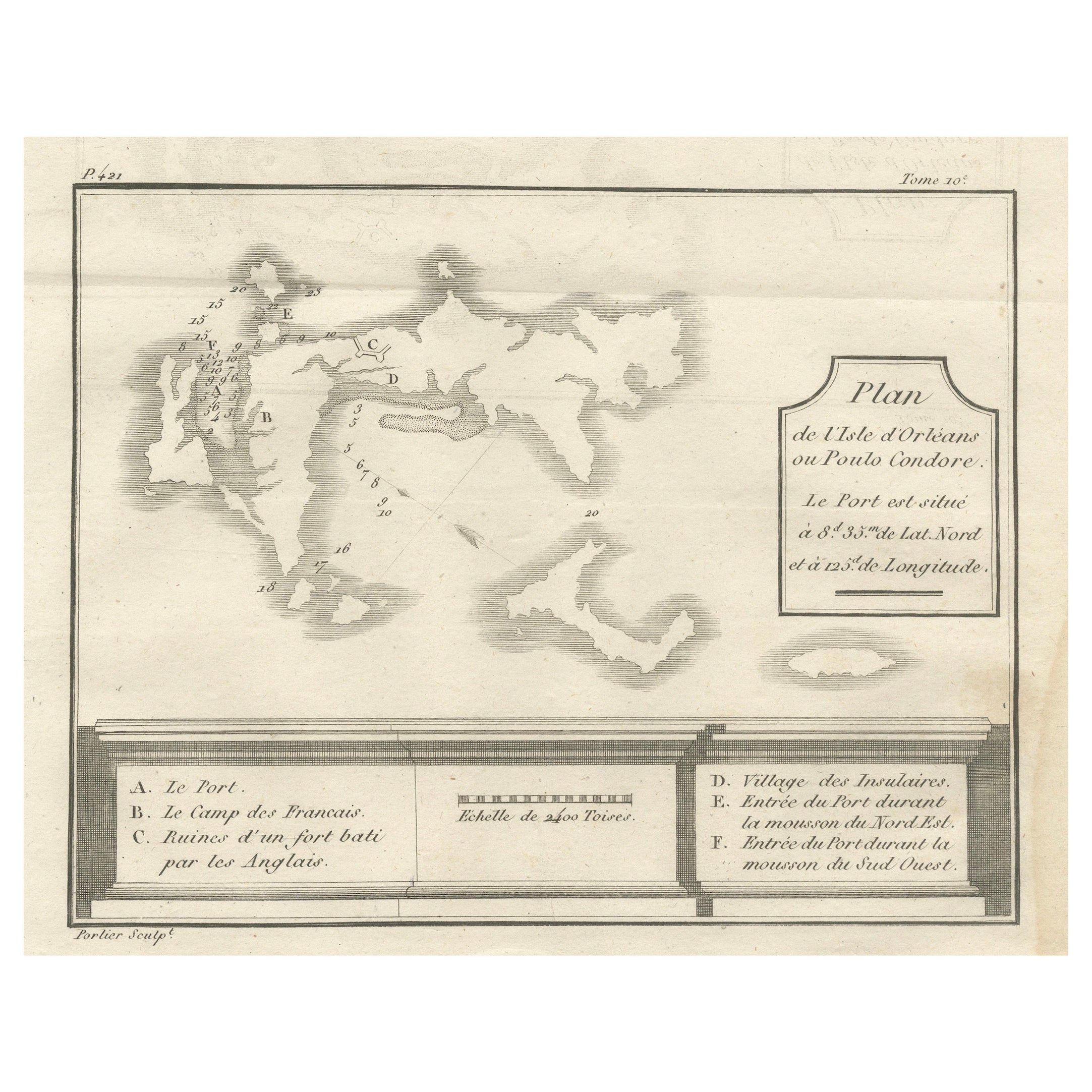
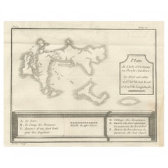
Plan of Poulo Condore (Côn Sơn Island) – Antique French Engraving, ca.1790
Located in Langweer, NL
Plan of Poulo Condore (Côn Sơn Island) – Antique French Engraving by Portier, c.1790
This antique French engraving, created by Portier around 1790, presents a detailed plan of Poulo...
Category
Antique Late 18th Century French Maps
Materials
Paper
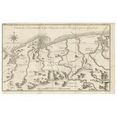
Antique Map of the Environs of Cap-Français, Saint-Domingue, c.1760
Located in Langweer, NL
Antique Map of the Environs of Cap-Français, Saint-Domingue, c.1760
This detailed 18th-century copperplate engraving, titled Carte des Environs du Cap Français et des Paroisses qui ...
Category
Antique Early 18th Century French Maps
Materials
Paper
Martinique Map by Rigobert Bonne – French Antique Map, c.1768
Located in Langweer, NL
Map of Martinique by Rigobert Bonne, circa 1768
This is a detailed antique map of Martinique titled “Isle de la Martinique,” engraved by Rigobert Bonne around 1768 for the Atlas Encyclopédique. Bonne, a renowned French hydrographer and successor to Bellin, is celebrated for his scientifically precise and elegantly engraved maps.
The map shows Martinique with its mountainous interior, rivers, and settlements labelled, including Fort Royal, Fort St. Pierre, Le Marin, and Le Prêcheur. Coastal features, bays, and capes are marked, along with anchorages important for maritime navigation in the 18th century. The depiction includes relief shown pictorially, characteristic of Bonne’s cartographic style, enhancing both geographic understanding and aesthetic appeal.
This copperplate engraving retains original hand colouring outlining the coastlines in delicate blue and brown tones, typical for the period. It served as a key reference for scholars, navigators, and colonial administrators during France’s colonial presence in the Caribbean.
Condition:
Good condition overall. A strong impression with bright, original hand-colour outlines. General age toning, faint offsetting, and a vertical fold as issued in the atlas. Margins ample all around for framing.
Framing suggestions:
This historic Caribbean map...
Category
Antique 1760s French Maps
Materials
Paper

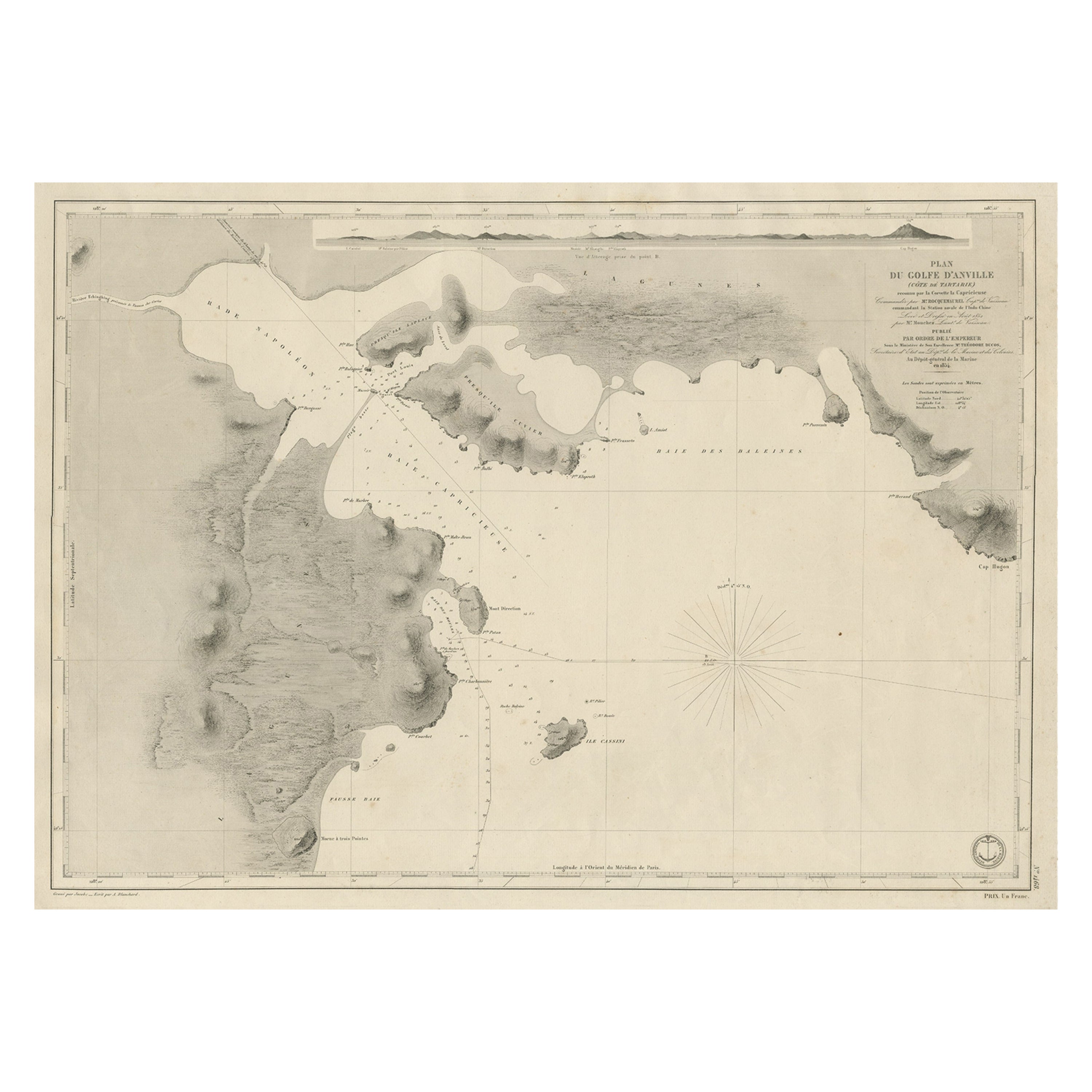
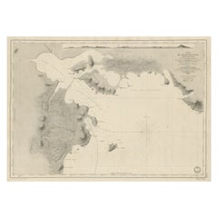
Antique Map of Part of the Chinese Coast, Explored by the French, Ca.1852
Located in Langweer, NL
Antique map titled 'Plan du Golfe D'Anville (Côte de Tartarie)'.
Old map of part of the Chinese coast, explored with the French corvette 'Caprieuse'. The Capricieuse was a late 2...
Category
Antique 1850s Maps
Materials
Paper
$659 Sale Price
34% Off
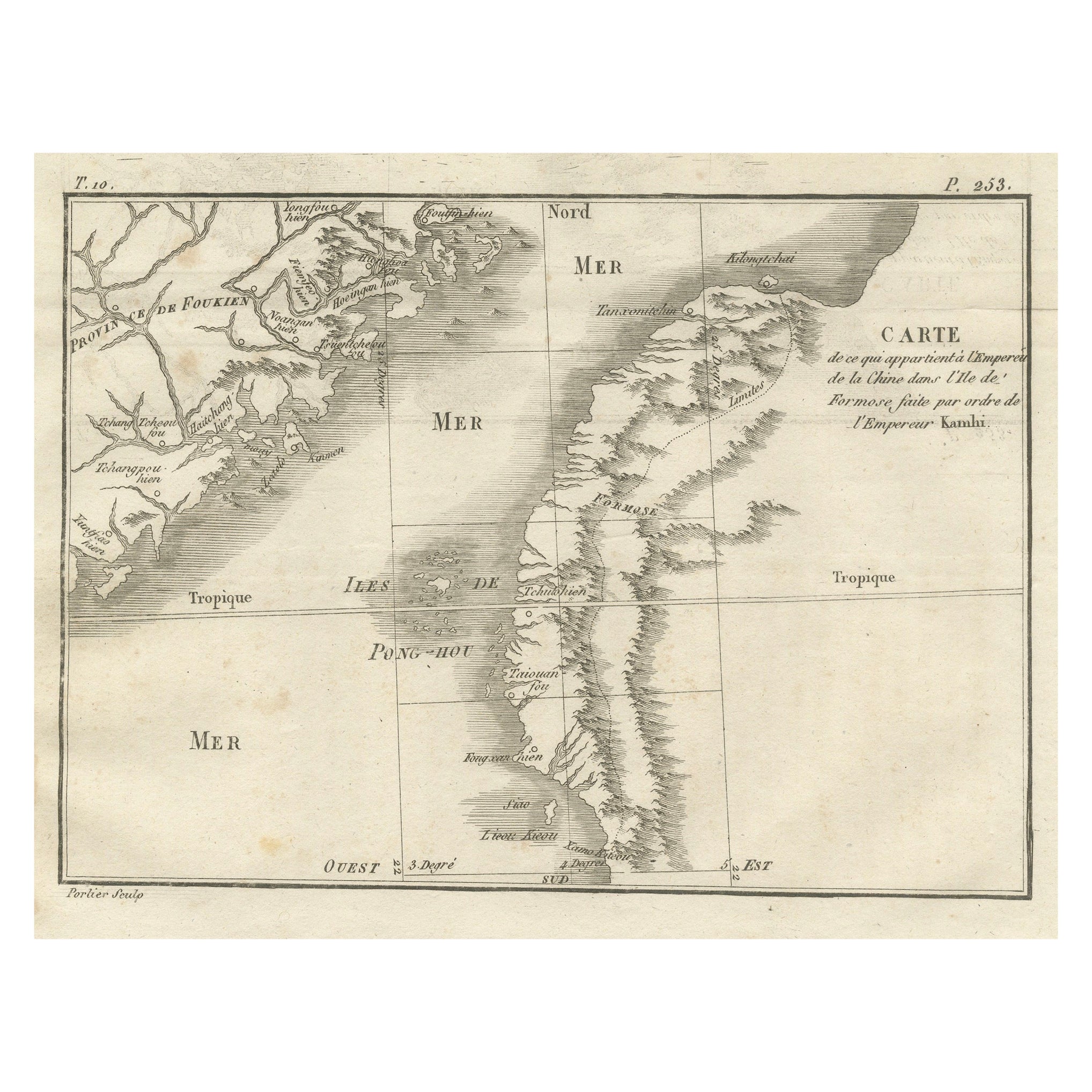
Map of Formosa and Pescadores – French Jesuit Engraving by Portier, c.1790
Located in Langweer, NL
Map of Formosa and Pescadores – French Jesuit Engraving by Portier, c.1790
This antique French map, engraved by Portier around 1790, depicts the island of Formosa (modern Taiwan), t...
Category
Antique Late 18th Century French Maps
Materials
Paper
You May Also Like
Antique French Map of Asia Including China Indoneseia India, 1783
Located in Amsterdam, Noord Holland
Very nice map of Asia. 1783 Dedie au Roy.
Additional information:
Country of Manufacturing: Europe
Period: 18th century Qing (1661 - 1912)
Condition: Overall Condition B (Good Used)...
Category
Antique 18th Century European Maps
Materials
Paper

$648 Sale Price
20% Off
Antique 1765 Wine Country Folding Map of France, Bordeau etc.
Located in Paonia, CO
Route du Carosse de Bordeaux, part de Paris tous les Mardis a 11 matin. a et pafse 1765 is a comprehensive map with two routes through the wine country of France starting in Paris going south...
Category
1760s Other Art Style Landscape Prints
Materials
Etching

Super Rare Antique French Map of Chine and the Chinese Empire, 1780
Located in Amsterdam, Noord Holland
Super Rare Antique French Map of Chine and the Chinese Empire, 1780
Very nice map of Asia. 1780 Made by Bonne.
Additional information:
Type: Map
...
Category
Antique 18th Century European Maps
Materials
Paper

$584 Sale Price
32% Off
Original Antique Map of China, Arrowsmith, 1820
Located in St Annes, Lancashire
Great map of China
Drawn under the direction of Arrowsmith
Copper-plate engraving
Published by Longman, Hurst, Rees, Orme and Brown, 1820
Unfr...
Category
Antique 1820s English Maps
Materials
Paper

West Coast of Africa; Guinea & Sierra Leone: Bellin 18th Century Map
Located in Alamo, CA
This is a Jacques Bellin copper-plate map entitled "Partie de la Coste de Guinee Dupuis la Riviere de Sierra Leona Jusquau Cap das Palmas", depicting the coast of Guinea and Sierra L...
Category
1740s Old Masters Landscape Prints
Materials
Engraving

Ancient Map of Senegal - Original Etching - 19th Century
Located in Roma, IT
Map of Senegal is an original etching realized by an anonymous engraver of the 19th Century.
Printed in series of "France Pittoresque" at the top center.
The state of preservation ...
Category
19th Century Figurative Prints
Materials
Etching
