Items Similar to Antique Map of West and Central Africa – Stieler Atlas, Justus Perthes 1857


Want more images or videos?
Request additional images or videos from the seller
1 of 10
Antique Map of West and Central Africa – Stieler Atlas, Justus Perthes 1857
$401.56
£302.31
€340
CA$553.17
A$619.52
CHF 323.26
MX$7,567.17
NOK 4,112.75
SEK 3,876.76
DKK 2,588.13
About the Item
Antique Map of West and Central Africa – Stieler Atlas, Justus Perthes 1857
This finely engraved map titled "Mittel- und Nord-Africa. Westl. Theil." was published in 1857 by Justus Perthes in Gotha, Germany, for the renowned Stieler’s Hand-Atlas. It was created under the direction of F. von Stülpnagel, whose meticulous cartographic work helped define 19th-century geographic understanding.
The map illustrates West and Central Africa in remarkable detail for the time, including the coastal regions from Senegal and Guinea to Nigeria and Cameroon, and inland regions such as the Sudan, Guinea Highlands, the Niger River basin, and parts of the vast Sahara Desert. Notable cities, rivers, and ethnic regions are labeled, such as Timbuktu, Bornu, Biafra, and the Gold Coast. The map also captures important caravan routes, European trading outposts, and missions.
The map's legend distinguishes between European colonies (Spanish, Portuguese, French, and English possessions), as well as native kingdoms and Islamic regions. Territories such as Morocco, Algeria, Senegambia, and Dahomey are marked, and major rivers like the Niger and Volta are shown snaking through the terrain.
An important historical feature is the map's reflection of mid-19th-century European knowledge of African geography. Much of the continent’s interior remained unmapped by Western cartographers, which is clearly indicated by lightly sketched or speculative regions labeled “Sahara” or “Unbekanntes Land” (Unknown Land). The map includes notes on recent explorations and the routes taken by famous explorers.
This map is a valuable collector’s item for those interested in colonial history, African geography, or antique cartography. It is particularly attractive for its clean design, original hand coloring, and clarity of labeling.
Condition report:
Very good condition with light age toning. A few minor foxing spots in the right margin. Vertical centerfold as issued. Edges clean and margins ample.
Framing tips:
Ideal for display in a simple black or dark wood frame with a wide cream-colored mat to emphasize the detailed engraving. Suitable for pairing with other continental or African-themed maps from the Stieler atlas series.
Technique: Engraving with original hand coloring
Maker: F. von Stülpnagel, Gotha, Justus Perthes, 1857
- Dimensions:Height: 14.77 in (37.5 cm)Width: 17.88 in (45.4 cm)Depth: 0.01 in (0.2 mm)
- Materials and Techniques:Paper,Engraved
- Place of Origin:
- Period:
- Date of Manufacture:1858
- Condition:Very good condition with light age toning. A few minor foxing spots in the right margin. Vertical centerfold as issued. Edges clean and margins ample.
- Seller Location:Langweer, NL
- Reference Number:Seller: BG-05552-481stDibs: LU3054346101582
About the Seller
5.0
Recognized Seller
These prestigious sellers are industry leaders and represent the highest echelon for item quality and design.
Platinum Seller
Premium sellers with a 4.7+ rating and 24-hour response times
Established in 2009
1stDibs seller since 2017
2,531 sales on 1stDibs
Typical response time: <1 hour
- ShippingRetrieving quote...Shipping from: Langweer, Netherlands
- Return Policy
Authenticity Guarantee
In the unlikely event there’s an issue with an item’s authenticity, contact us within 1 year for a full refund. DetailsMoney-Back Guarantee
If your item is not as described, is damaged in transit, or does not arrive, contact us within 7 days for a full refund. Details24-Hour Cancellation
You have a 24-hour grace period in which to reconsider your purchase, with no questions asked.Vetted Professional Sellers
Our world-class sellers must adhere to strict standards for service and quality, maintaining the integrity of our listings.Price-Match Guarantee
If you find that a seller listed the same item for a lower price elsewhere, we’ll match it.Trusted Global Delivery
Our best-in-class carrier network provides specialized shipping options worldwide, including custom delivery.More From This Seller
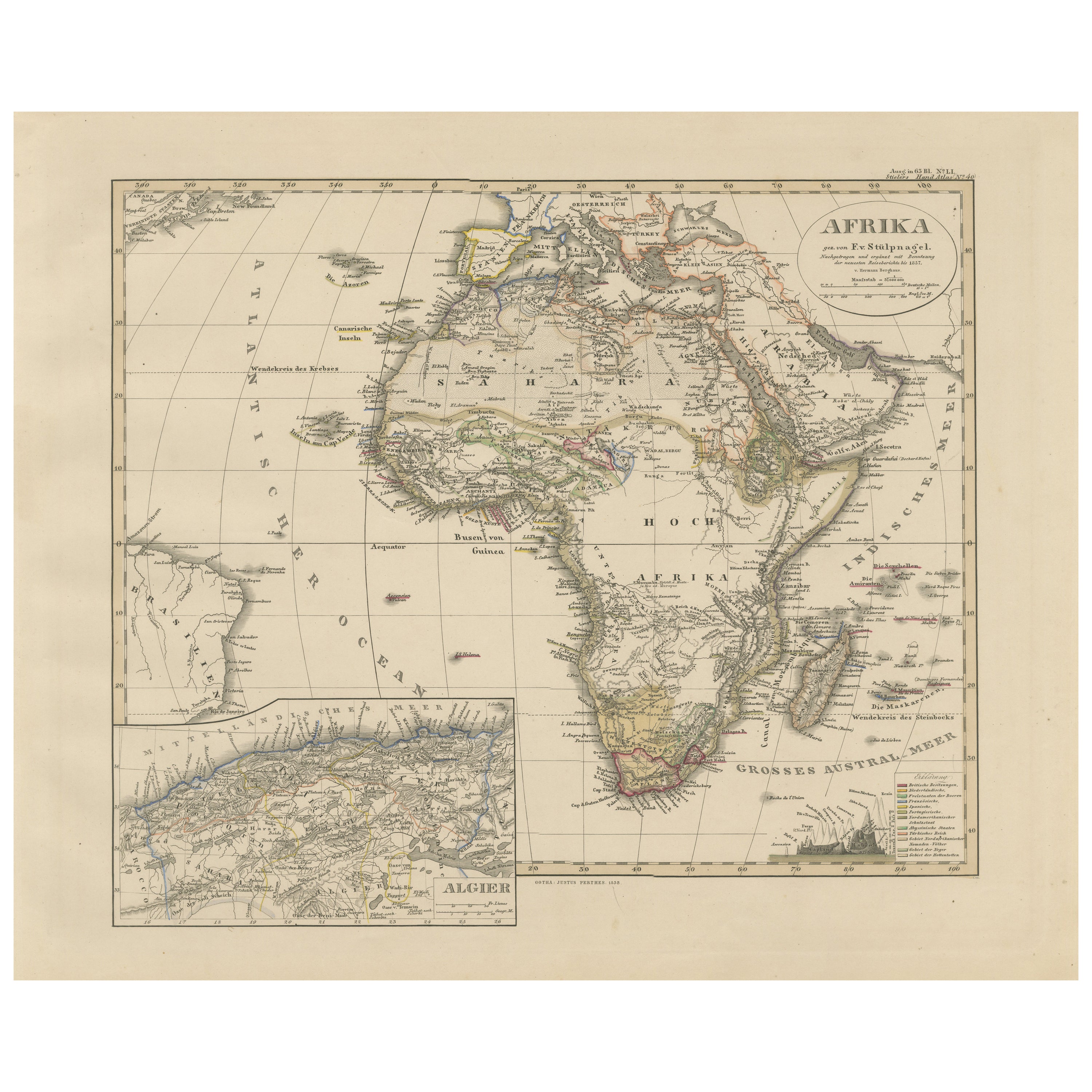
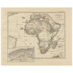
View AllColorfull Antique Map of Africa with Algeria Inset – Stieler Atlas 1858
Located in Langweer, NL
Antique Map of Africa with Algeria Inset – Stieler Atlas 1858
This antique map of Africa, engraved by F. von Stülpnagel and published by Justus Perthes in 1858, is a finely detailed...
Category
Antique Mid-19th Century German Maps
Materials
Paper
Antique Map of the African Continent with Inset of the Nile River Delta, c.1870
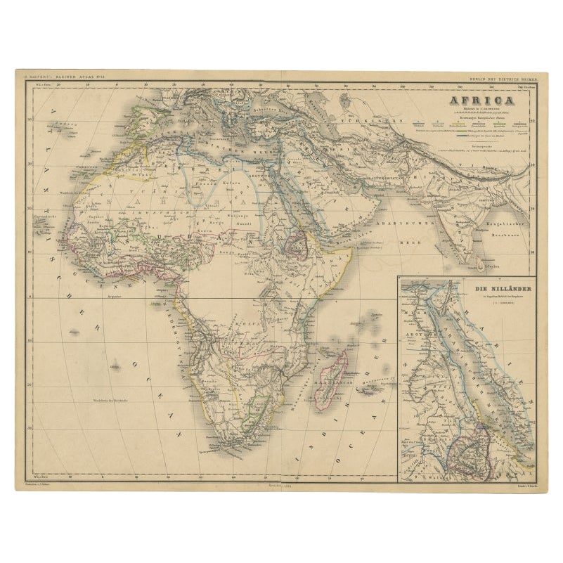
Located in Langweer, NL
Antique map titled 'Africa'. Old map of the African continent. This map originates from 'H. Kiepert's Kleiner Atlas der Neueren Geographie für Schule...
Category
Antique 19th Century Maps
Materials
Paper

$302 Sale Price
20% Off
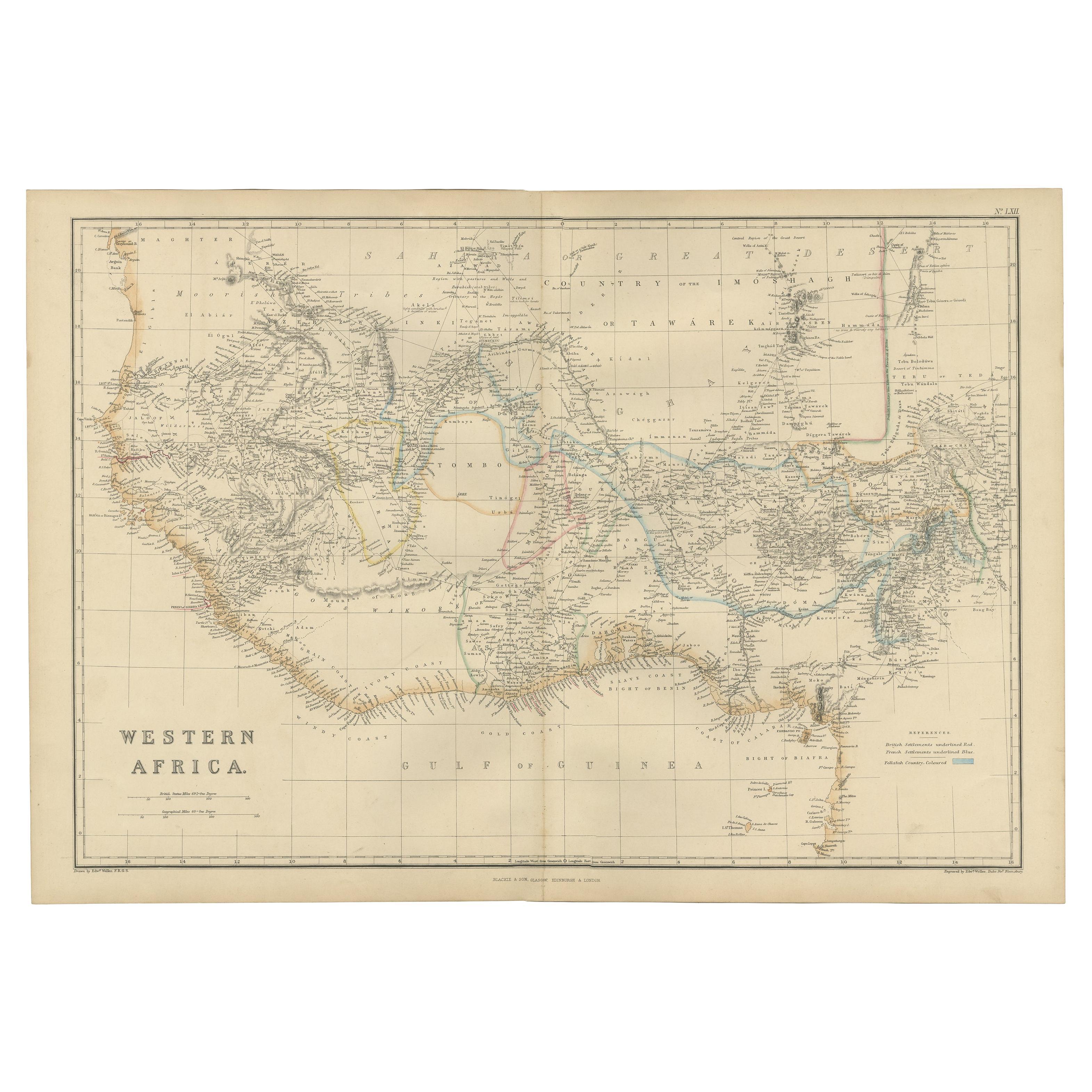
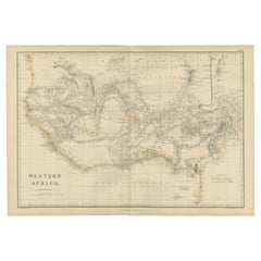
Western Africa Antique Map by W. G. Blackie, 1859
Located in Langweer, NL
The antique map titled 'Western Africa' presents an original depiction of the region. Originating from 'The Imperial Atlas of Modern Geography,' this map was published by W. G. Black...
Category
Antique Mid-19th Century Maps
Materials
Paper
$236 Sale Price
20% Off
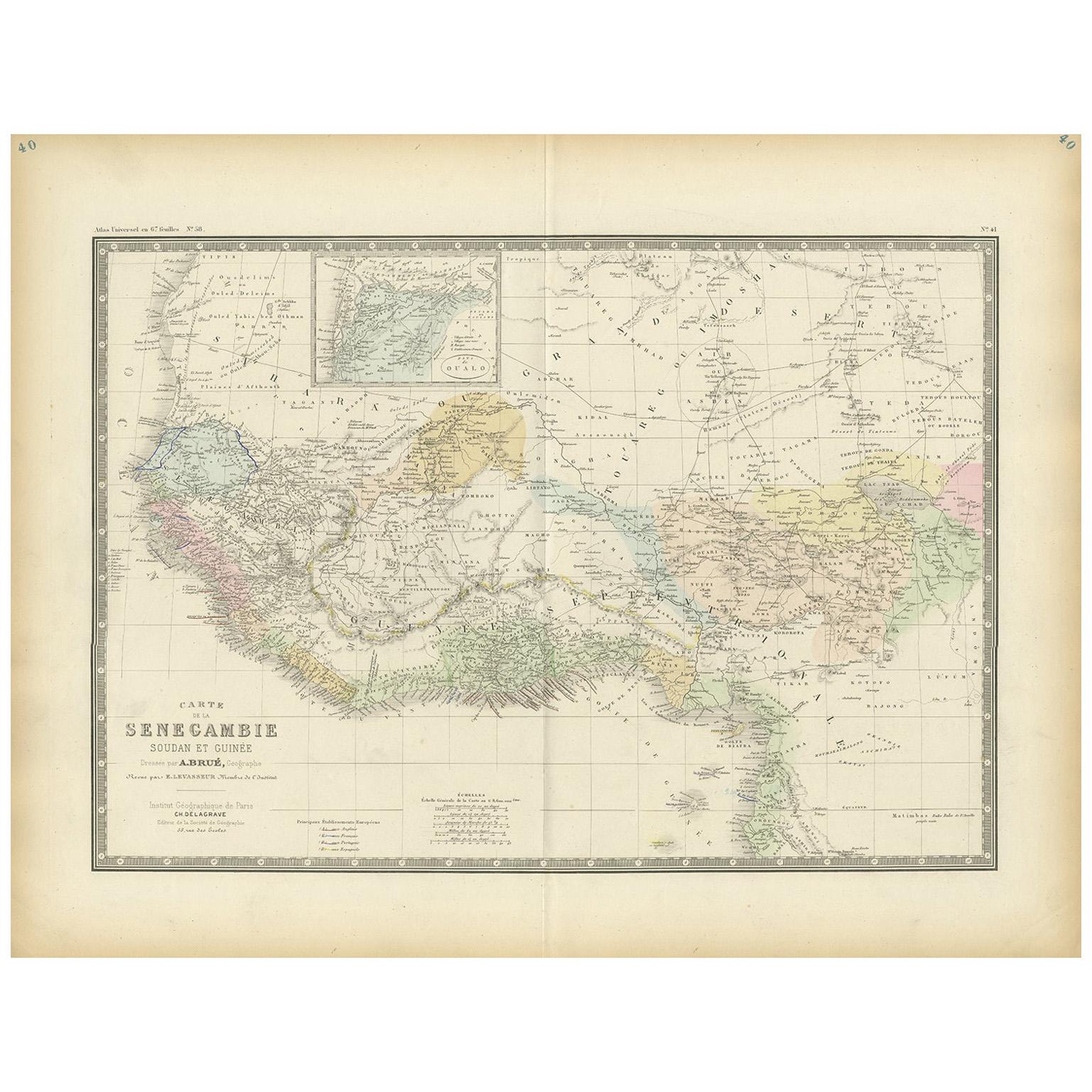
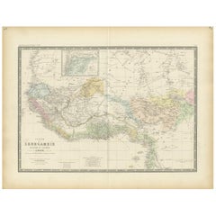
Antique Map of Western Africa by Levasseur '1875'
Located in Langweer, NL
Antique map titled 'Carte de la Senegambie Soudan et Guinée'. Large map of Western Africa. This map originates from 'Atlas de Géographie Moderne Physique et Politique' by A. Levasseu...
Category
Antique Late 19th Century Maps
Materials
Paper
$377 Sale Price
20% Off
Antique Map of Africa by Lapie, 1842
Located in Langweer, NL
Antique map titled 'Carte d'Afrique'. Map of Africa. This map originates from 'Atlas universel de géographie ancienne et moderne (..)' by Pierre M. Lapie...
Category
Antique Mid-19th Century Maps
Materials
Paper

$566 Sale Price
20% Off
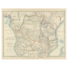
Antique Map of Central Africa, 1903, With Colonial Territories Explorers Routes
Located in Langweer, NL
Antique Map of Central Africa, 1903, Featuring Colonial Territories and Explorers’ Routes
This antique map, titled "Central Africa," was engraved and published in 1903 by W. & A.K. ...
Category
Early 20th Century Maps
Materials
Paper
You May Also Like
Africa. North-West Part. Century Atlas antique vintage map
Located in Melbourne, Victoria
'The Century Atlas. Africa. Southern Part'
Original antique map, 1903.
Central fold as issued. Map name and number printed on the reverse corners.
Sheet 40cm by 29.5cm.
Category
Early 20th Century Victorian More Prints
Materials
Lithograph

Original Antique Map of Africa by Dower, circa 1835
Located in St Annes, Lancashire
Nice map of Africa
Drawn and engraved by J.Dower
Published by Orr & Smith. C.1835
Unframed.
Free shipping
Category
Antique 1830s English Maps
Materials
Paper

Africa. Central. Century Atlas antique vintage map
Located in Melbourne, Victoria
'The Century Atlas. Africa. Central'
Inset map of 'Madagascar'.
Original antique map, 1903.
Central fold as issued. Map name and number printed on the reverse corners.
Sheet 29.5cm...
Category
Early 20th Century Victorian More Prints
Materials
Lithograph

Africa. North-East Part. Century Atlas antique vintage map
Located in Melbourne, Victoria
'The Century Atlas. Africa. North-East Part'
Original antique map, 1903.
Inset map of 'Nile Delta and Suez Canal'.
Central fold as issued. Map name and nu...
Category
Early 20th Century Victorian More Prints
Materials
Lithograph

Ancient Map of Senegal - Original Etching - 19th Century
Located in Roma, IT
Map of Senegal is an original etching realized by an anonymous engraver of the 19th Century.
Printed in series of "France Pittoresque" at the top center.
The state of preservation ...
Category
19th Century Figurative Prints
Materials
Etching

Africa. Southern Part. Century Atlas antique vintage map
Located in Melbourne, Victoria
'The Century Atlas. Africa. Southern Part'
Original antique map, 1903.
Inset maps of 'Cape Town', 'Johannesburg' and 'Ladysmith'.
Central fold as issued. Map name and number printe...
Category
Early 20th Century Victorian More Prints
Materials
Lithograph
