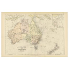
Items Similar to Australia, New Zealand, and Neighbouring Islands Map 1858

Want more images or videos?
Request additional images or videos from the seller
1 of 13
Australia, New Zealand, and Neighbouring Islands Map 1858
$396
£299.98
€340
CA$548.60
A$615.29
CHF 322.22
MX$7,476.36
NOK 4,091.62
SEK 3,879.15
DKK 2,588.68
About the Item
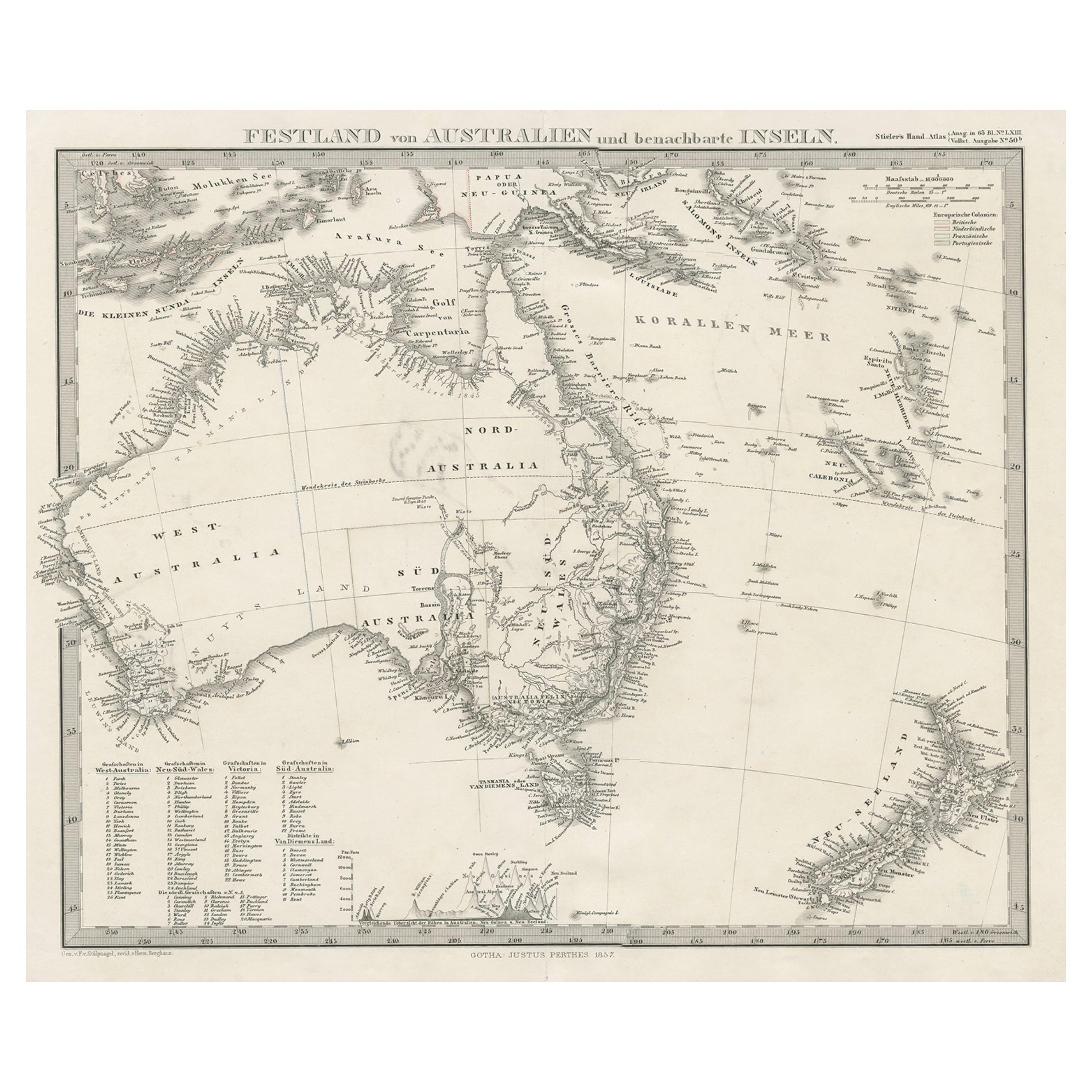
Australia and Neighbouring Islands Map 1858
This attractive antique print shows “Festland von Australien und benachbarte Inseln” meaning “Mainland Australia and neighbouring islands.” Published in 1858 by Justus Perthes in Gotha as part of Adolf Stieler’s esteemed Hand-Atlas, this map was created under the direction of cartographer F. v. Stülpnagel.
The map presents Australia divided into its mid-19th-century colonial regions, including New South Wales, Victoria, South Australia, Western Australia, and the Northern Territory, here labelled as part of “Nord Australia.” Tasmania is included at the south-east corner, with major cities such as Sydney, Melbourne, Adelaide, Perth, and Hobart clearly marked. The map also features neighbouring islands such as New Guinea, Timor, New Caledonia, and New Zealand with both North and South Islands labelled.
This map is significant for its depiction of Australia during the early colonial period, showing exploration routes, settlements, and geographic knowledge before full federation in 1901. It also highlights European colonial claims and trade routes within the broader Asia-Pacific region, reflecting the geopolitical interests of the era.
Technique: Copperplate engraving with original hand colouring to delineate colonial borders and territorial claims. German titles and detailed annotations are engraved with precision, typical of Stieler’s cartographic standards.
Condition summary: Excellent condition with strong impression, minimal age toning, no tears, repairs, or significant foxing. Colours remain vivid and paper is firm and stable.
Framing tips: This detailed map of Australia and its neighbouring islands will look impressive in a dark wood or black frame to emphasise its historical and geographical value. Pair with a wide ivory or cream mount to soften the presentation and highlight its cartographic clarity. UV-protective glass is recommended to preserve the engraved lines and original colouring for long-term display.
- Dimensions:Height: 14.77 in (37.5 cm)Width: 17.88 in (45.4 cm)Depth: 0.01 in (0.2 mm)
- Materials and Techniques:Paper,Engraved
- Place of Origin:
- Period:
- Date of Manufacture:1857
- Condition:Condition summary: Excellent condition with strong impression, minimal age toning, no tears, repairs, or significant foxing. Colours remain vivid and paper is firm and stable.
- Seller Location:Langweer, NL
- Reference Number:Seller: BG-05552-581stDibs: LU3054345813942
About the Seller
5.0
Recognized Seller
These prestigious sellers are industry leaders and represent the highest echelon for item quality and design.
Platinum Seller
Premium sellers with a 4.7+ rating and 24-hour response times
Established in 2009
1stDibs seller since 2017
2,517 sales on 1stDibs
Typical response time: <1 hour
- ShippingRetrieving quote...Shipping from: Langweer, Netherlands
- Return Policy
Authenticity Guarantee
In the unlikely event there’s an issue with an item’s authenticity, contact us within 1 year for a full refund. DetailsMoney-Back Guarantee
If your item is not as described, is damaged in transit, or does not arrive, contact us within 7 days for a full refund. Details24-Hour Cancellation
You have a 24-hour grace period in which to reconsider your purchase, with no questions asked.Vetted Professional Sellers
Our world-class sellers must adhere to strict standards for service and quality, maintaining the integrity of our listings.Price-Match Guarantee
If you find that a seller listed the same item for a lower price elsewhere, we’ll match it.Trusted Global Delivery
Our best-in-class carrier network provides specialized shipping options worldwide, including custom delivery.More From This Seller
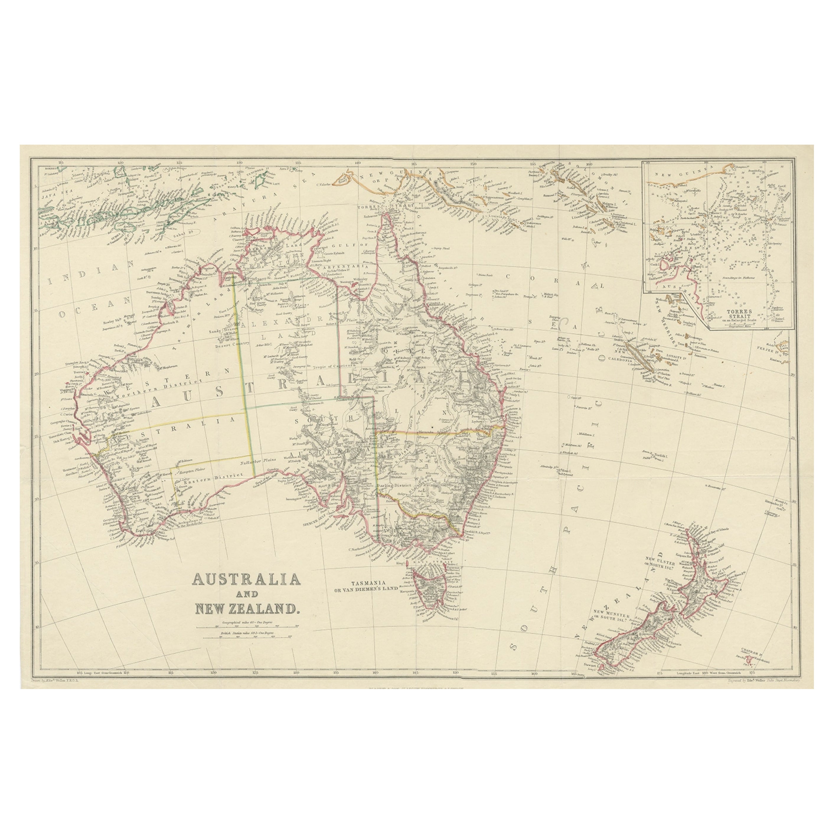
View AllAntique Map of Australia and New Zealand, c.1860
Located in Langweer, NL
Antique map titled 'Australia and New Zealand'. Unusual edition of this map of Australia and New Zealand, on very thin paper and multiple folding lines. Source unknown, to be determi...
Category
Antique 19th Century Maps
Materials
Paper

$130 Sale Price
20% Off
German Antique Map of Australia and New Zealand, 1857
Located in Langweer, NL
Antique map Australia titled 'Festland von Australien und benachbarte Inseln'. Detailed map of Australia and New Zealand, including excellent det...
Category
Antique 19th Century Maps
Materials
Paper

$232 Sale Price
20% Off
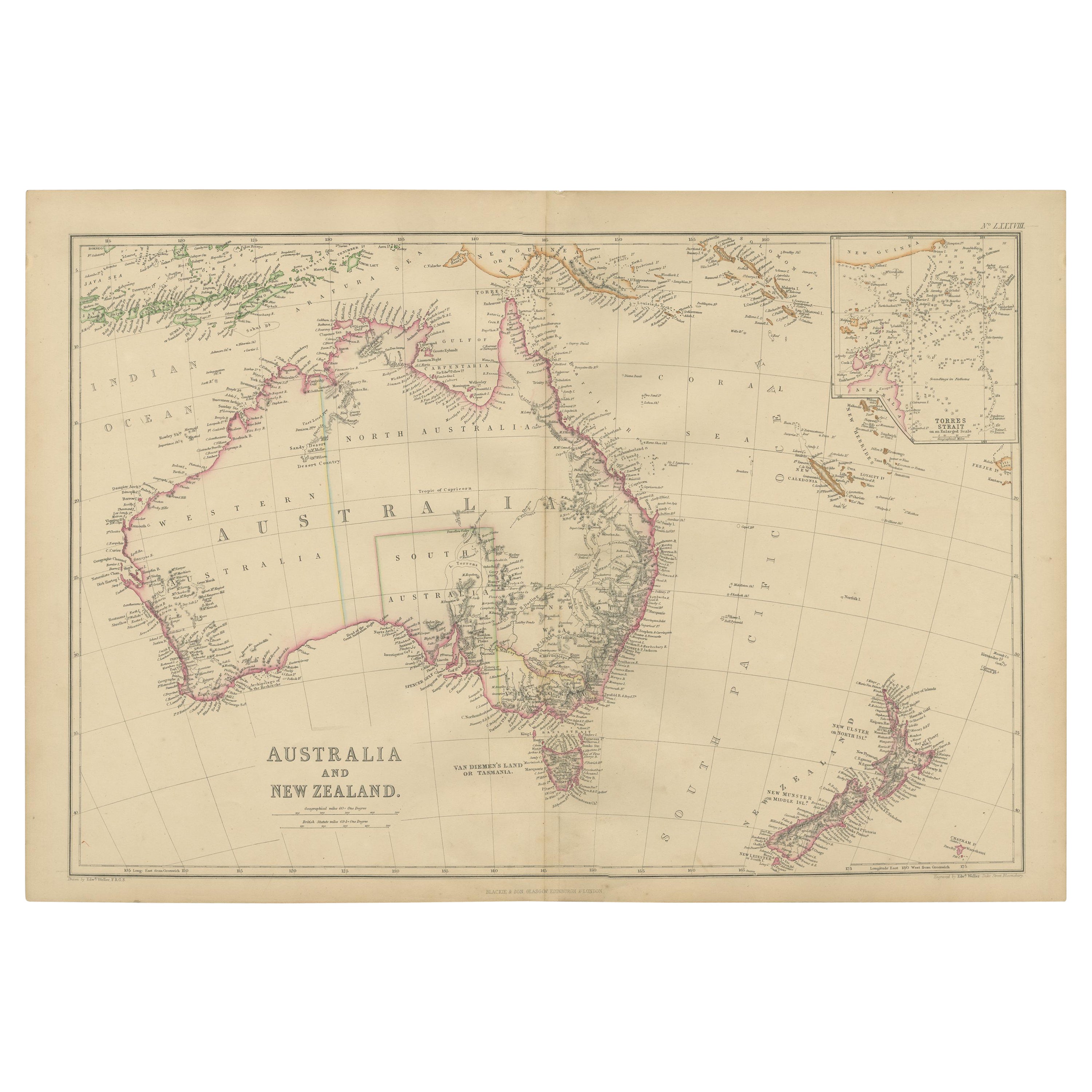
Antique Map of Australia and New Zealand by W. G. Blackie, 1859
Located in Langweer, NL
Antique map titled 'Australia and New Zealand'. Original antique map of Australia and New Zealand with inset map of the Torres Strait. This map originates from ‘The Imperial Atlas of...
Category
Antique Mid-19th Century Maps
Materials
Paper

$232 Sale Price
20% Off
1882 Map of Australia and New Zealand with Regional and Geographical Features
Located in Langweer, NL
This 1882 map of Australia and New Zealand, published by Blackie and Son as part of the 'Comprehensive Atlas and Geography of the World,' provides a detailed and insightful look at t...
Category
Antique 1880s Maps
Materials
Paper
Mid-19th Century Map of Australasia by Carl Flemming - 1855
Located in Langweer, NL
Title: "Mid-19th Century Map of Australasia by Carl Flemming - 1855"
Description: This original 1855 antique map from the Sohr-Berghaus Atlas, created by Carl Flemming, is a detaile...
Category
Antique 1850s Maps
Materials
Paper

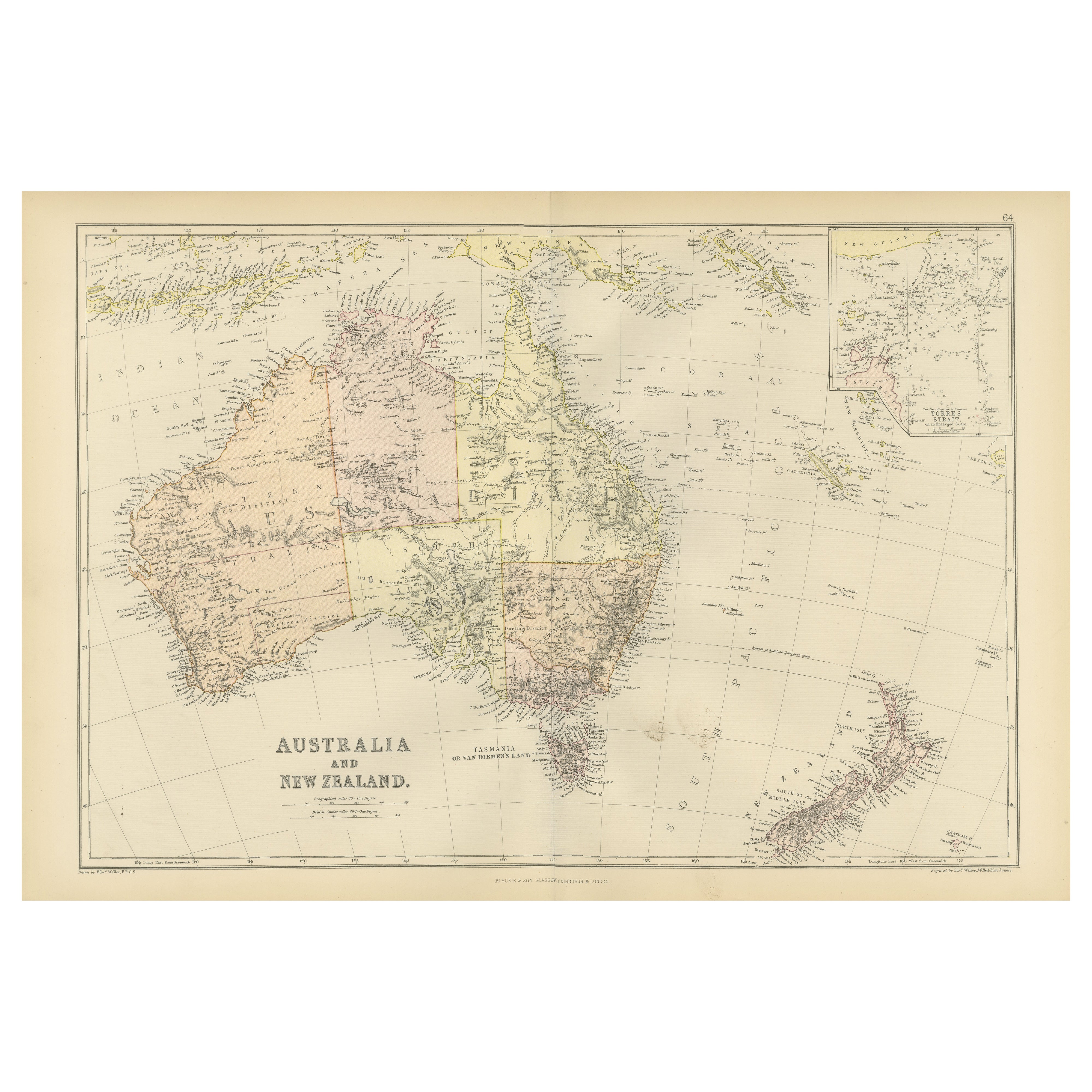
Antique Map of Australia and surrounding Islands by F. von Stülpnagel, 1850
Located in Langweer, NL
Antique map titled 'Festland von Asutralien und benachbarte Inseln'. Map showing Australia, New Zealand, Southern New-Guinea and surrounding islands. This map originates from Stieler...
Category
Antique Mid-19th Century Maps
Materials
Paper

$179 Sale Price
30% Off
You May Also Like
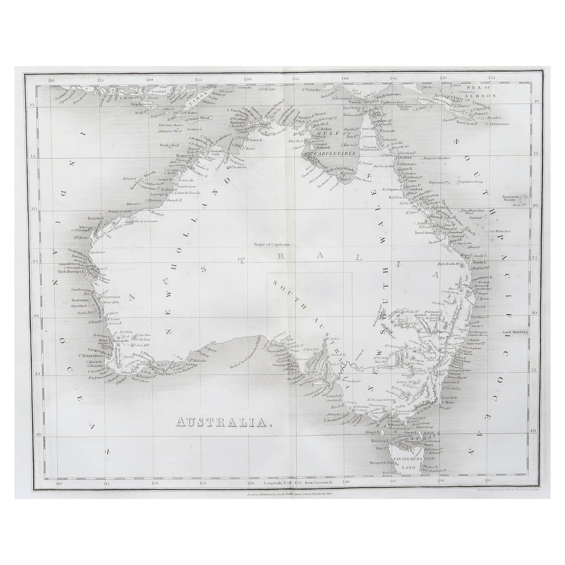
Original Antique Map of Australia by Dower, circa 1835
Located in St Annes, Lancashire
Nice map of Australia
Drawn and engraved by J.Dower
Published by Orr & Smith. C.1835
Unframed.
Free shipping
Category
Antique 1830s English Maps
Materials
Paper

Australia, Tallis antique map, 1851
Located in Melbourne, Victoria
'Australia'
With decorative border surrounds and vignettes including a view of Sydney, Kangaroos, Natives of Australia Felix, Australian Parrots and Cockatoos and Natives of the Tri...
Category
19th Century Naturalistic Landscape Prints
Materials
Engraving

Large Original Antique Map of Australia by Sidney Hall, 1847
Located in St Annes, Lancashire
Great map of Australia
Drawn and engraved by Sidney Hall
Steel engraving
Original colour outline
Published by A & C Black. 1847
Unframed
Free shipping.
Category
Antique 1840s Scottish Maps
Materials
Paper

Original Antique Map of Tasmania, Australia by Dower, circa 1835
Located in St Annes, Lancashire
Nice map of Tasmania
Drawn and engraved by J.Dower
Published by Orr & Smith. C.1835
Unframed.
Free shipping
Category
Antique 1830s English Maps
Materials
Paper

Ancient Map of Oceania - Original Etching - 19th century
Located in Roma, IT
This Map of Oceania is an etching realized in the 19th century.
The state of preservation of the artwork is good. At the top of the paper, the inscription “Longitudine del Meridiano...
Category
19th Century More Prints
Materials
Etching

Original Antique Map of The World by Dower, circa 1835
Located in St Annes, Lancashire
Nice map of the World
Drawn and engraved by J.Dower
Published by Orr & Smith. C.1835
Unframed.
Free shipping
Category
Antique 1830s English Maps
Materials
Paper

More Ways To Browse
Wood Minimalist Chair
Antique Imperial Furniture
Gold Modern Coffee Table
Large Side Tables
18th Century Gilded Furniture
Japanese Silver Ceramics
One Of A Kind Chair
Used Oak Dining Room Chairs
17th Century Plate
Childrens Vintage Poster
Chinese Ship
Nursery Art
Vintage Travel Poster Mid Century
Desk Key
Woven Silk Art
Carved Cabriole Table
Dark Antique Table
White Wooden Table