Items Similar to Benelux Antique Map – Netherlands, Belgium & Luxembourg by Perthes, 1857
Want more images or videos?
Request additional images or videos from the seller
1 of 10
Benelux Antique Map – Netherlands, Belgium & Luxembourg by Perthes, 1857
$584.62
£440.13
€495
CA$805.36
A$901.95
CHF 470.62
MX$11,016.91
NOK 5,987.68
SEK 5,644.10
DKK 3,768.01
About the Item
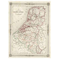
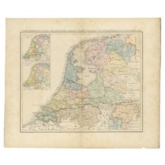
1857 Map of Netherlands, Belgium & Luxembourg – Justus Perthes Engraving
Antique map titled "Niederlande, Belgien und Luxemburg," published by Justus Perthes in Gotha in 1857. This finely engraved and hand-colored map presents a comprehensive view of the Low Countries in the mid-19th century, capturing the evolving political landscape of the Netherlands, the recently independent Kingdom of Belgium (1830), and the Grand Duchy of Luxembourg.
The map details all provincial divisions with delicate hand-applied color, highlighting major cities such as Amsterdam, Brussels, Antwerp, The Hague, Ghent, Liège, and Luxembourg. The Zuiderzee and North Sea coastlines are prominently featured, along with rivers, canals, roads, and early railways that shaped commerce and mobility in the region.
Topographical relief is rendered with precision, and a clear legend at the left provides information on scale and symbols. Each territory—Dutch, Belgian, and Luxembourgish—is bordered in color, reflecting its independent governance at the time. This edition reflects the period following Belgian independence and before major modern state boundary changes.
This piece is ideal for collectors of European history, Benelux cartography, or 19th-century political geography. The map stands out both for its geographic accuracy and its decorative appeal, suitable for framing and display.
Condition report:
Very good condition. Minor toning to outer margins. Hand-coloring remains vivid and clear. No tears, repairs, or foxing. Please inspect image carefully for full detail.
Framing suggestions:
We recommend a walnut or black wood frame with a soft ivory mat. A thin red, green, or gold inner accent line can be used to echo the border colors. Ideal for display in a library, office, or study.
Technique: Copperplate engraving with original hand-coloring
Maker: Justus Perthes, Gotha, 1857
- Dimensions:Height: 17.88 in (45.4 cm)Width: 14.77 in (37.5 cm)Depth: 0.01 in (0.2 mm)
- Materials and Techniques:Paper,Engraved
- Place of Origin:
- Period:
- Date of Manufacture:1857
- Condition:Very good condition. Minor toning to outer margins. Hand-coloring remains vivid and clear. No tears, repairs, or foxing. Please inspect image carefully for full detail.
- Seller Location:Langweer, NL
- Reference Number:Seller: BG-05552-341stDibs: LU3054346118542
About the Seller
5.0
Recognized Seller
These prestigious sellers are industry leaders and represent the highest echelon for item quality and design.
Platinum Seller
Premium sellers with a 4.7+ rating and 24-hour response times
Established in 2009
1stDibs seller since 2017
2,533 sales on 1stDibs
Typical response time: <1 hour
- ShippingRetrieving quote...Shipping from: Langweer, Netherlands
- Return Policy
Authenticity Guarantee
In the unlikely event there’s an issue with an item’s authenticity, contact us within 1 year for a full refund. DetailsMoney-Back Guarantee
If your item is not as described, is damaged in transit, or does not arrive, contact us within 7 days for a full refund. Details24-Hour Cancellation
You have a 24-hour grace period in which to reconsider your purchase, with no questions asked.Vetted Professional Sellers
Our world-class sellers must adhere to strict standards for service and quality, maintaining the integrity of our listings.Price-Match Guarantee
If you find that a seller listed the same item for a lower price elsewhere, we’ll match it.Trusted Global Delivery
Our best-in-class carrier network provides specialized shipping options worldwide, including custom delivery.More From This Seller
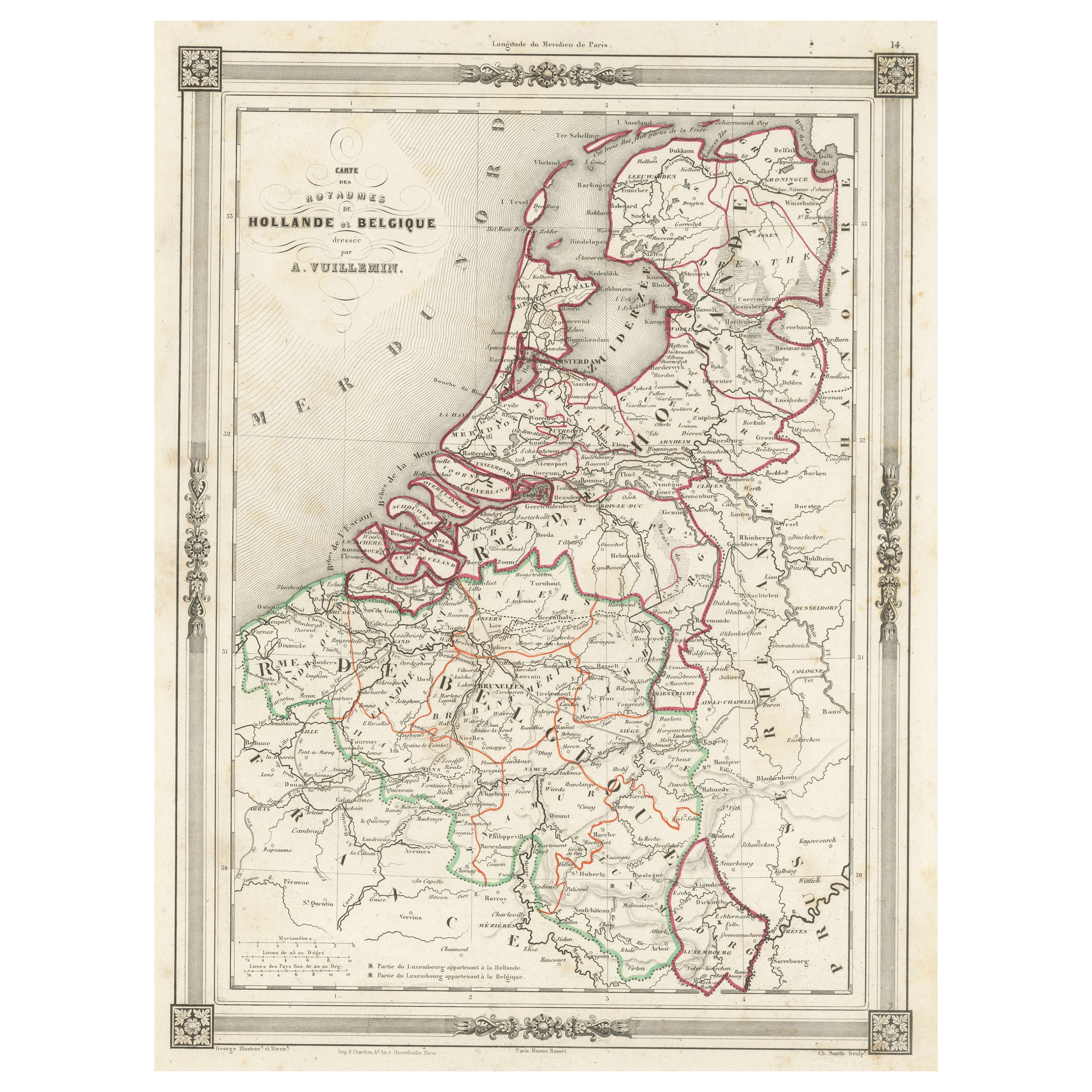
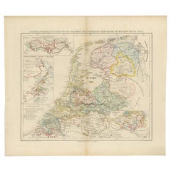
View AllAntique Map of the Netherlands, Belgium and Luxembourg
Located in Langweer, NL
Antique map titled 'Carte des Royaumes Hollande et Belgique'. Attractive map of the Netherlands, Belgium and Luxembourg. This map originates fro...
Category
Antique Mid-19th Century Maps
Materials
Paper
$113 Sale Price
20% Off
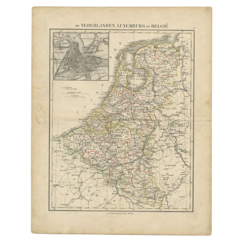
Antique Map of the Netherlands, Belgium and Luxembourg by Petri, c.1873
Located in Langweer, NL
Antique map titled 'De Nederlanden, Luxemburg en België'. Old map depicting the Netherlands, Luxembourg and Belgium. With an inset map of Amsterdam. T...
Category
Antique 19th Century Maps
Materials
Paper
$110 Sale Price
20% Off
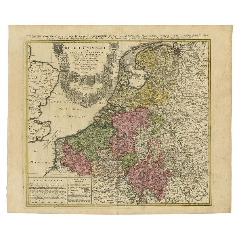
Antique Map of the Seventeen Provinces of Netherlands, Belgium, Luxembourg, 1748
By Homann Heirs
Located in Langweer, NL
Antique map titled 'Belgii Universi seu Inferioris Germaniae quam XVII Provinciae (..)'.
Map of the Seventeen Provinces after Tobias Meier, published by Homann's Heirs in 1748. The...
Category
Antique 18th Century Maps
Materials
Paper

$434 Sale Price
20% Off
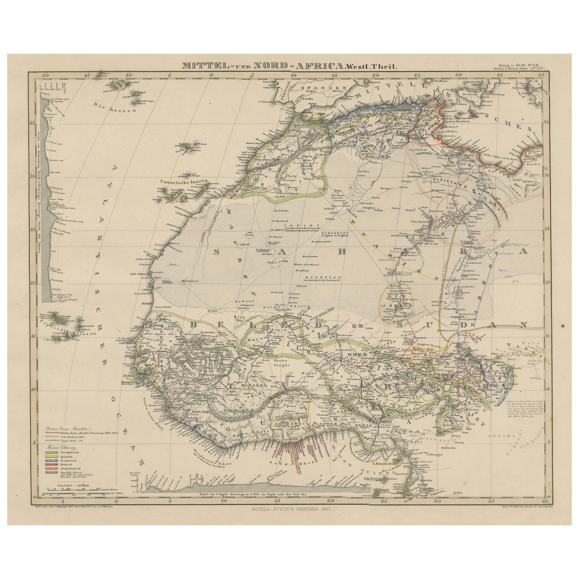
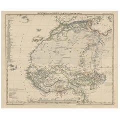
Antique Map of West and Central Africa – Stieler Atlas, Justus Perthes 1857
Located in Langweer, NL
Antique Map of West and Central Africa – Stieler Atlas, Justus Perthes 1857
This finely engraved map titled "Mittel- und Nord-Africa. Westl. Theil." was published in 1857 by Justus ...
Category
Antique Mid-19th Century German Maps
Materials
Paper
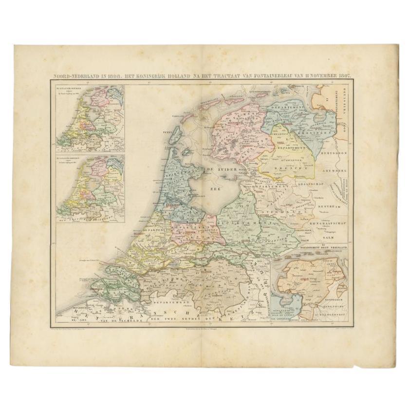
Antique Map of the Netherlands in 1808 by Mees, 1857
Located in Langweer, NL
Antique map titled 'Noord-Nederland in 1808. Het Koningrijk Holland na het tractaat van Fontainebleau van 11 november 1807'. Map of the Netherlands in 1808. This map originates from ...
Category
Antique 19th Century Maps
Materials
Paper
$120 Sale Price
20% Off
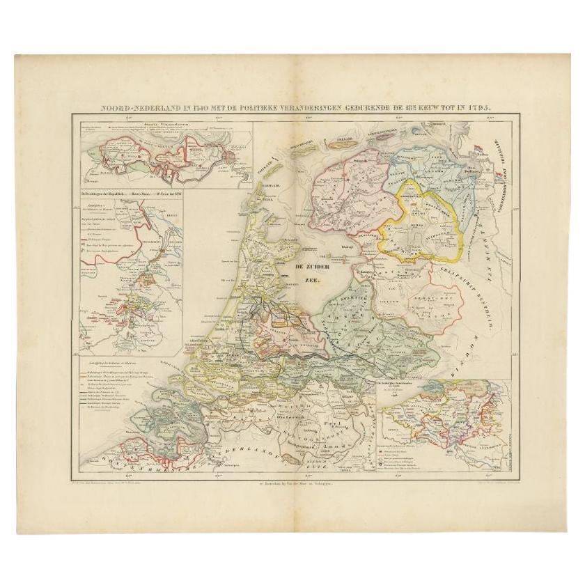
Antique Map of the Netherlands in 1740 by Mees, 1857
Located in Langweer, NL
Antique map titled 'Noord-Nederland in 1740 met de Politieke veranderingen gedurende de 18e eeuw tot in 1795'. Map of the Netherlands in 1740. This map originates from 'Historische A...
Category
Antique 19th Century Maps
Materials
Paper
$120 Sale Price
20% Off
You May Also Like
1752 Vaugoundy Map of Flanders : Belgium, France, and the Netherlands, Ric.a002
Located in Norton, MA
Large Vaugoundy Map of Flanders:
Belgium, France, and the Netherlands
Colored -1752
Ric.a002
Description: This is a 1752 Didier Robert de Vaugondy map of Flanders. The map de...
Category
Antique 17th Century Unknown Maps
Materials
Paper

Antique Colored Belgium Map Flandria Gallica Flanders Henricus Hondius
Located in Dayton, OH
Antique hand colored map of Flanders, Belgium, engraved by Henricus Hondius.
Sans frame - 21.25” x 18”.
Category
Antique 19th Century Renaissance Maps
Materials
Paper

$280 Sale Price
20% Off
Original Antique Map or City Plan of Amsterdam, Netherlands. Circa 1835
Located in St Annes, Lancashire
Nice map of Amsterdam
Drawn and engraved by J.Dower
Published by Orr & Smith. C.1835
Unframed.
Free shipping
Category
Antique 1830s English Maps
Materials
Paper

Antique Belgian Chocolate Mold
Located in New York, NY
Antique Belgian chocolate heavy metal chocolate mold. A great graphic pattern sculptural element addition for any room.
Category
Early 20th Century Belgian Arts and Crafts Historical Memorabilia
Materials
Metal
1812 United States Map, by Pierre Tardieu, Antique French Map Depicting the U.S.
By Pierre François Tardieu
Located in Colorado Springs, CO
1812 "United States of Nth America -- Carte des Etats-Unis De L'Amerique Septentrionale" Two-Sheet Map by Tardieu
This attractive map, published in Paris in 1812, is one of the most rare large format maps from the period. It features a view of the East Coast of the U.S. from Maryland to just below South Carolina. Additionally, Ellicott’s plan for the City of Washington D.C. is included at the top right and an illustration of Niagara Falls is shown at the bottom right with a description in both French and English. This extremely detailed map not only depicts the mountainous regions of the southeastern U.S., but also includes names of regions, rivers, and towns.
Based on the first state of Arrowsmith’s 4-sheet map of the United States, this map is completely engraved by Tardieu in Paris and showcases high quality engravings. This detailed map of the recently independent United States includes one of the largest and earliest examples of the Ellicott plan of Washington DC.
The artist, Pierre François Tardieu (PF Tardieu) was a very well-known map engraver, geographer, and illustrator. Awarded a bronze medal by King Louis-Phillipe for the accuracy and beauty of his map-making, Tardieu produced many fine works including maps of Louisiana...
Category
Antique 1810s French Maps
Materials
Paper

1864 Map of North America, Antique Hand-Colored Map, by Adolphe Hippolyte Dufour
Located in Colorado Springs, CO
Offered is a map of North America entitled Amerique du Nord from 1864. This rare, separately published wall map was produced by Adolphe Hippolyte Dufour. This map includes vibrant an...
Category
Antique 1860s French Maps
Materials
Paper
