Items Similar to Duchy of Brunswick-Lüneburg, 1595: A Renaissance Cartographic Masterpiece
Want more images or videos?
Request additional images or videos from the seller
1 of 7
Duchy of Brunswick-Lüneburg, 1595: A Renaissance Cartographic Masterpiece
$335.77
$419.7120% Off
£249.78
£312.2220% Off
€280
€35020% Off
CA$459.78
CA$574.7320% Off
A$511.22
A$639.0220% Off
CHF 266.93
CHF 333.6620% Off
MX$6,222.76
MX$7,778.4520% Off
NOK 3,405.90
NOK 4,257.3820% Off
SEK 3,191.17
SEK 3,988.9620% Off
DKK 2,131.49
DKK 2,664.3620% Off
Shipping
Retrieving quote...The 1stDibs Promise:
Authenticity Guarantee,
Money-Back Guarantee,
24-Hour Cancellation
About the Item
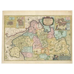
Title: "Braunschweig and Lüneburg Duchies: Authentic Depiction by Abraham Ortelius"
This is an exquisite example of Abraham Ortelius’s cartographic craftsmanship: an original antique copper engraving depicting the Duchies of Braunschweig (Brunswick) and Lüneburg. Dated to 1595 and published in Antwerp, this map is hand-colored in outline, capturing the geographical nuances of the region during the Renaissance.
Stretching northward to the Elbe River and encompassing the notable city of Hamburg, the map is meticulously annotated with place names, including villages, rivers, woodlands, and other significant topographical features. Each engraved name and icon is a testament to the thorough surveying methods of the era and Ortelius's attention to detail.
A notable feature of this piece is the Renaissance title cartouche in the upper right corner, which is both an ornamental and a symbolic representation of the period's aesthetic. In the lower right, a mileage scale rendered in the map's color palette serves a practical purpose, guiding the measurements of distance with historical accuracy.
The reverse side of the map holds Latin text, offering additional context and scholarly content to this cartographic masterpiece. As a work of Abraham Ortelius, a renowned figure in the development of early modern cartography, this map holds significant value for collectors, historians, and enthusiasts of geographical history. It is a splendid reflection of the era's cartographic elegance and an enduring piece of Renaissance artistry.
Abraham Ortelius (1527–1598) was a notable figure in the history of cartography, credited with creating the first modern atlas. He was a Flemish cartographer and geographer, recognized as the 'father of modern geography' by many historians.
Here are some key points about his life and work:
1. **Early Life and Career**: Ortelius was born in Antwerp, which was part of the Habsburg Netherlands during a period known as the Dutch Golden Age. He began his career as a map engraver and dealer. He traveled extensively across Europe, gathering geographical information and establishing connections with other scholars.
2. **Theatrum Orbis Terrarum**: Ortelius's most famous contribution to cartography was the "Theatrum Orbis Terrarum" (Theatre of the World), first published in 1570. This is considered the first true modern atlas in that it was a systematically collected and standardized set of maps, all of similar size, and bound together into a book.
3. **Cartographic Advances**: Ortelius is known for hypothesizing that the continents were once joined together before drifting apart, a notion that would much later be developed into the theory of continental drift. His work often included maps from other cartographers, which he compiled and sometimes improved upon based on the latest geographical knowledge.
4. **Impact and Legacy**: The "Theatrum Orbis Terrarum" went through numerous editions and was published in several languages, reflecting its wide-reaching impact. Ortelius was appointed as the Royal Geographer to King Philip II of Spain, a position that reflected the respect he commanded in his field.
5. **Collaborations**: Ortelius also maintained a network of correspondents across Europe, including prominent figures such as Gerardus Mercator. This network was crucial for the exchange of cartographic knowledge and discoveries.
6. **Death and Commemoration**: After his death, Ortelius was hailed for his contributions to geography and cartography. His work was carried on by others, including his nephew, who continued to publish editions of the "Theatrum."
Ortelius's work not only marked a significant advancement in map-making but also reflected the broader cultural and scientific developments of the Renaissance. His atlas helped lay the foundation for the way we think about maps and geography today.
- Dimensions:Height: 16.93 in (43 cm)Width: 11.03 in (28 cm)Depth: 0 in (0.02 mm)
- Materials and Techniques:Paper,Engraved
- Period:
- Date of Manufacture:1595
- Condition:Repaired: A tear in the top is professionally closed and the right border has been strengthened. Good. Soiling and offset and scattered minor browning. A larger dirt spot in the top edge, far outside the image. Study the images carefully.
- Seller Location:Langweer, NL
- Reference Number:Seller: BG-13672-41stDibs: LU3054338040562
About the Seller
5.0
Recognized Seller
These prestigious sellers are industry leaders and represent the highest echelon for item quality and design.
Platinum Seller
Premium sellers with a 4.7+ rating and 24-hour response times
Established in 2009
1stDibs seller since 2017
2,511 sales on 1stDibs
Typical response time: <1 hour
- ShippingRetrieving quote...Shipping from: Langweer, Netherlands
- Return Policy
Authenticity Guarantee
In the unlikely event there’s an issue with an item’s authenticity, contact us within 1 year for a full refund. DetailsMoney-Back Guarantee
If your item is not as described, is damaged in transit, or does not arrive, contact us within 7 days for a full refund. Details24-Hour Cancellation
You have a 24-hour grace period in which to reconsider your purchase, with no questions asked.Vetted Professional Sellers
Our world-class sellers must adhere to strict standards for service and quality, maintaining the integrity of our listings.Price-Match Guarantee
If you find that a seller listed the same item for a lower price elsewhere, we’ll match it.Trusted Global Delivery
Our best-in-class carrier network provides specialized shipping options worldwide, including custom delivery.More From This Seller
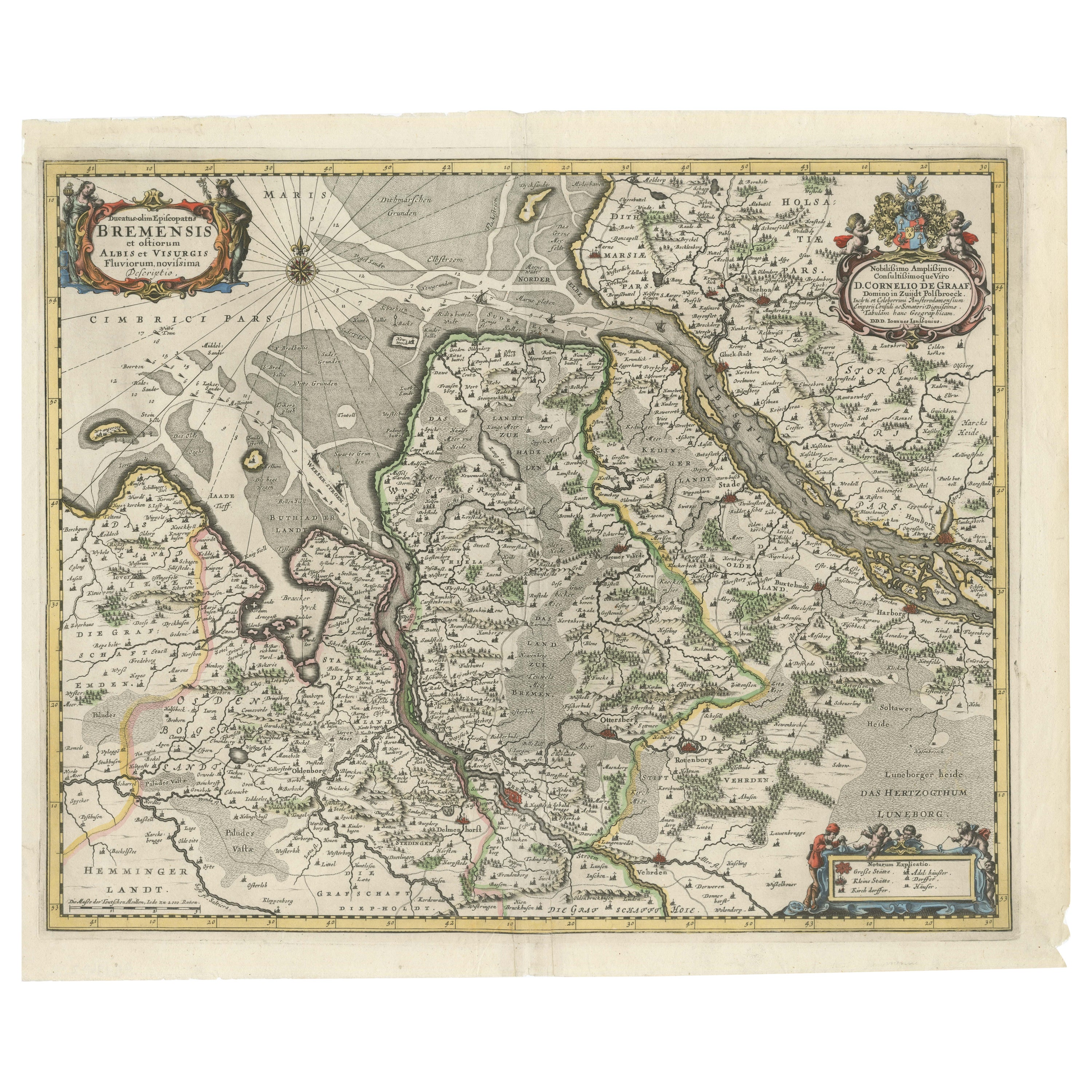
View AllJohannes Janssonius' 17th-Century Map of the Duchy of Bremen in Germany
Located in Langweer, NL
The map titled "Ducatus olim Episcopatus Bremensis et ostiorum Albis et Visurgis Fluviorum novissima Descriptio" by Johannes Janssonius provides a rich historical and geographical il...
Category
Antique 1650s Maps
Materials
Paper
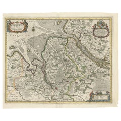
$738 Sale Price
20% Off
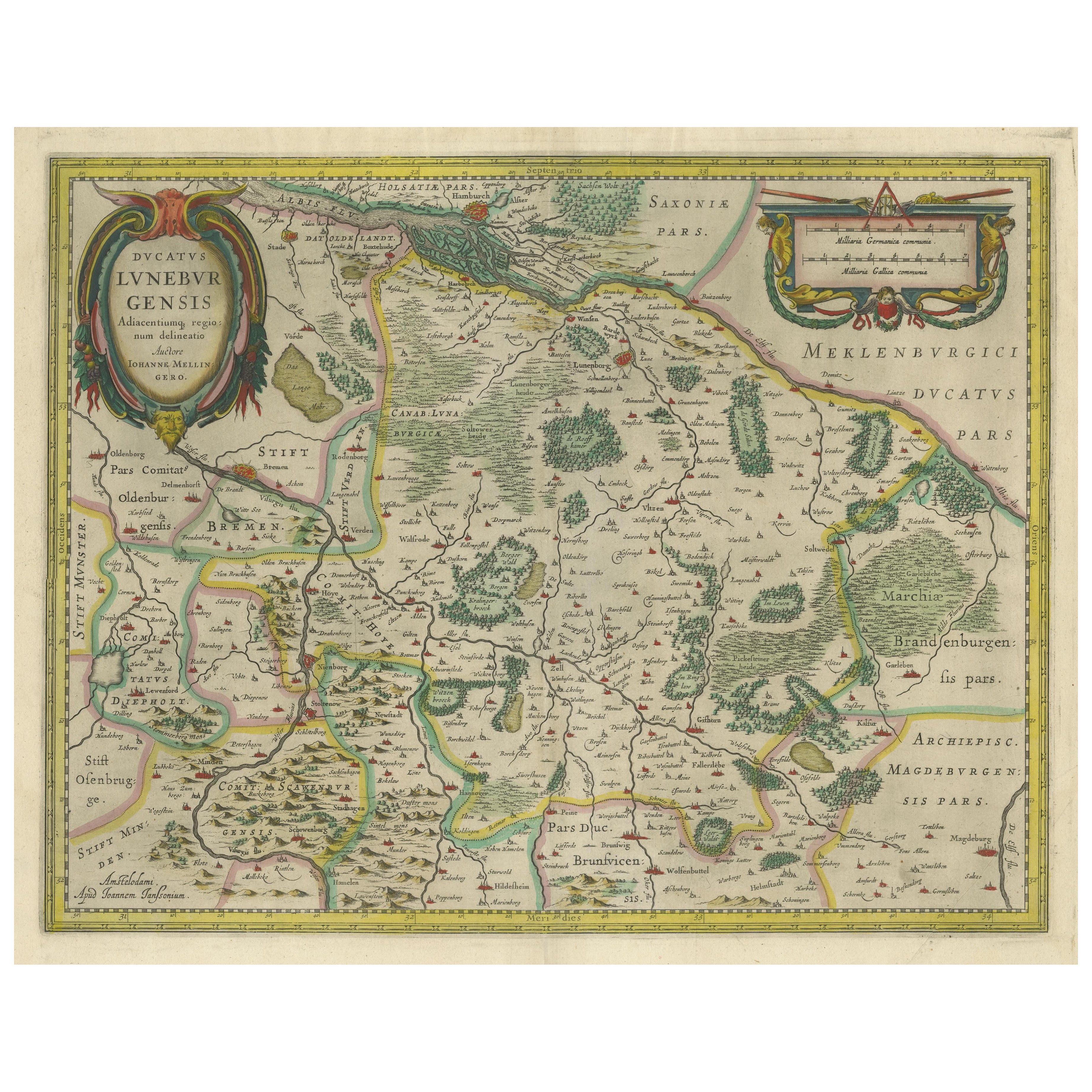
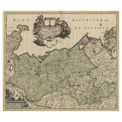
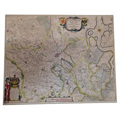
Antique Map of the Duchy of Lüneburg, Lower Saxony, Germany
Located in Langweer, NL
Antique map titled 'Ducatus Luneburgensis (..)'. Map of the Duchy of Lüneburg in Lower Saxony, Germany. Published by J. Janssonius, circa 1664.
Jan Janssonius (also known as Johann ...
Category
Antique Mid-17th Century Maps
Materials
Paper

$518 Sale Price
20% Off
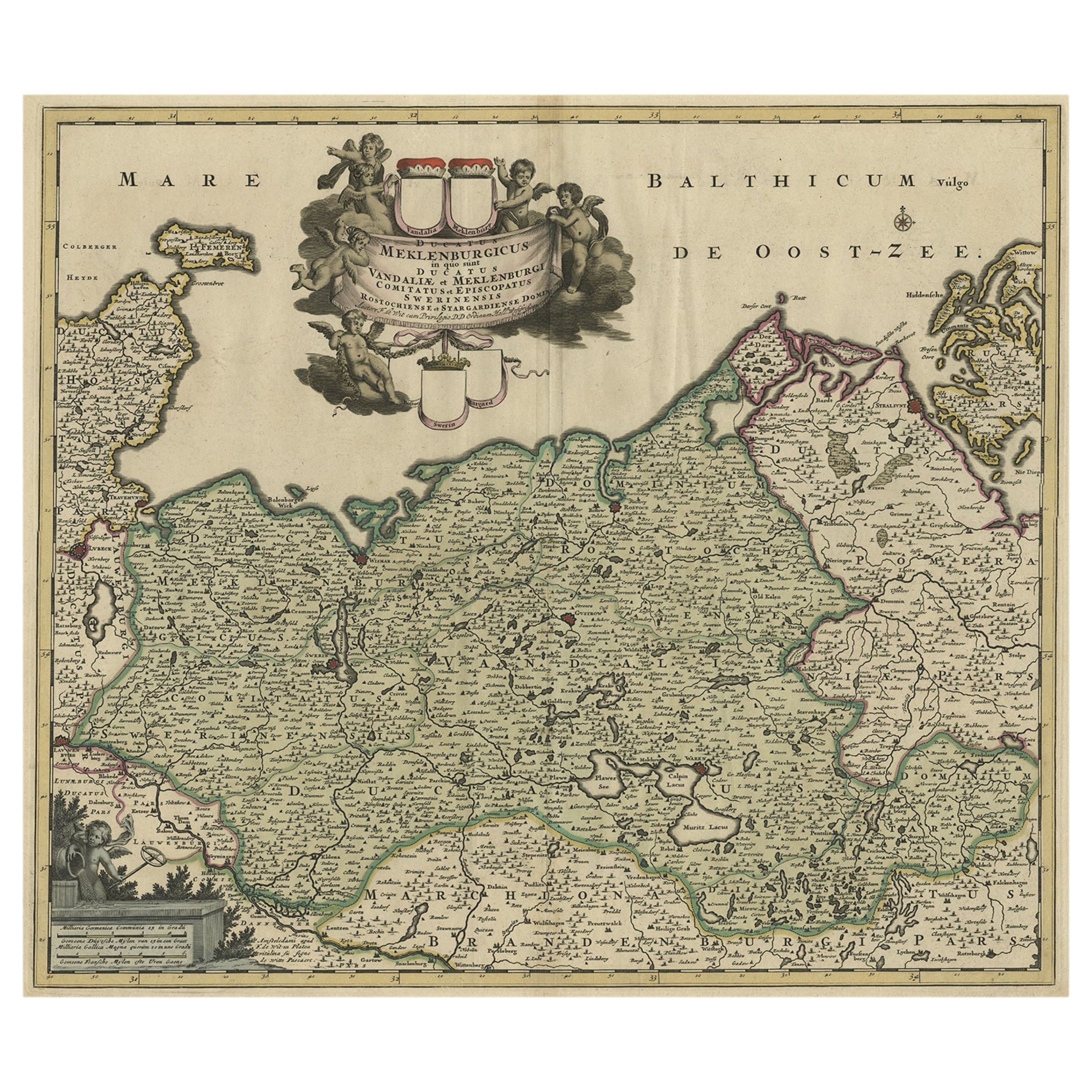
A Handsome & Detailed Map of the Duchy of Mecklenburg & Pomerania, Germany, 1680
Located in Langweer, NL
Antique map titled 'Ducatus Meklenburgicus in quo sunt Ducatus Vandaliae et Meklenburgi Ducatus et Comitatus Swerinensis.'
A handsome and detailed map of the Duchy of Mecklenburg...
Category
Antique 1680s Maps
Materials
Paper
$709 Sale Price
20% Off
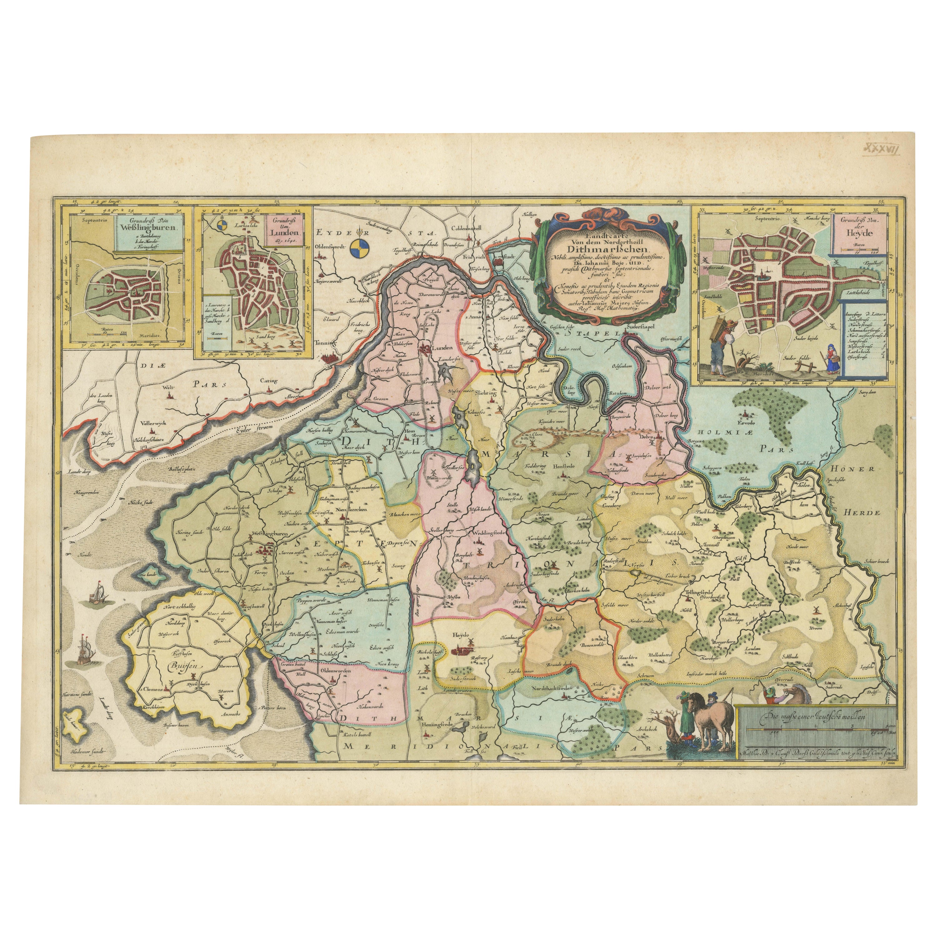
The 17th Century Map of Northern Dithmarschen and Its Towns in Germany
Located in Langweer, NL
This is a detailed colored copperplate engraving depicting northern Dithmarschen, accompanied by town plans of Weßlingburen (now Wesselburen), Lunden, and Heyde (now Heide) at the to...
Category
Antique 1640s Maps
Materials
Paper
$1,093 Sale Price
20% Off
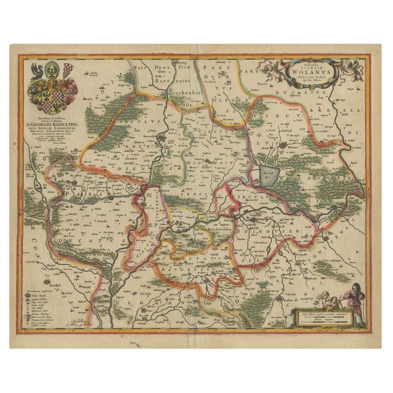
Antique Map of Lower Silesia of The Famous Mapmaker Blaeu, c.1650
Located in Langweer, NL
Antique map titled 'Ducatus Silesiae Wolanus'. \
Antique map depicting lower Silesia with the cities of Wolow (Wohlau), Winsko (Winzig), Herrnstadt, Chobie (Koben), Lubin (Lüben), R...
Category
Antique 17th Century Maps
Materials
Paper

$815 Sale Price
20% Off
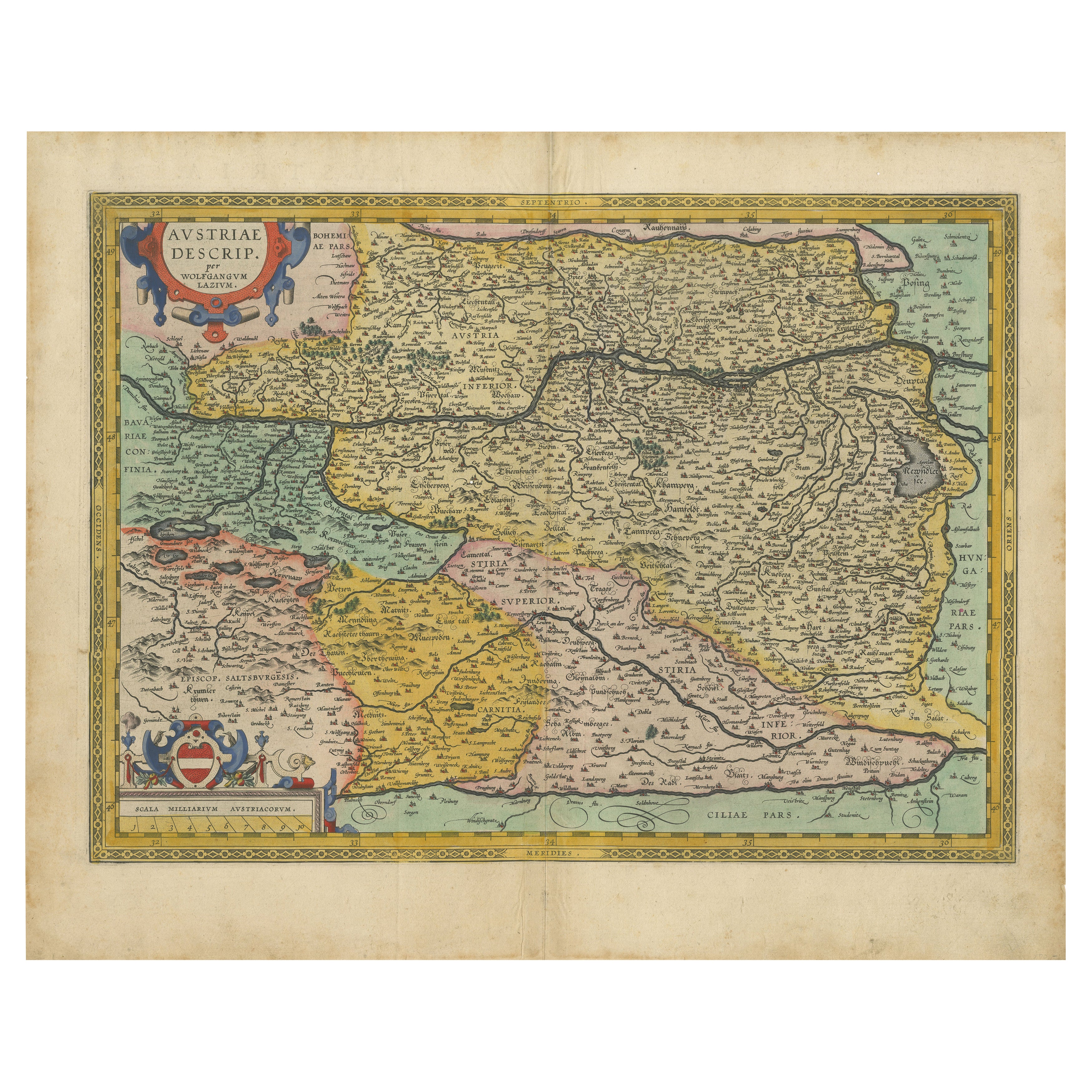
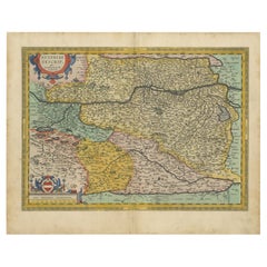
Austria by Wolfgang Lazius – A Magnificent 16th-Century Map from Ortelius
Located in Langweer, NL
Title:
Avstriae Descrip – Wolfgang Lazius’ Map of Austria, 16th Century
Description:
This extraordinary map of Austria pays homage to the Austrian humanist and cartographer Wo...
Category
Antique 16th Century Maps
Materials
Paper
You May Also Like
Prussia, Poland, N. Germany, Etc: A Hand-colored 17th Century Map by Janssonius
By Johannes Janssonius
Located in Alamo, CA
This is an attractive hand-colored copperplate engraved 17th century map of Prussia entitled "Prussia Accurate Descripta a Gasparo Henneberg Erlichensi", published in Amsterdam by Joannes Janssonius in 1664. This very detailed map from the golden age of Dutch cartography includes present-day Poland, Latvia, Lithuania, Estonia and portions of Germany. This highly detailed map is embellished by three ornate pink, red, mint green and gold...
Category
Antique Mid-17th Century Dutch Maps
Materials
Paper

17th Century Hand-Colored Map of a Region in West Germany by Janssonius
By Johannes Janssonius
Located in Alamo, CA
This attractive highly detailed 17th century original hand-colored map is entitled "Archiepiscopatus Maghdeburgensis et Anhaltinus Ducatus cum terris adjacentibus". It was published ...
Category
Antique Mid-17th Century Dutch Maps
Materials
Paper

1633 Map Entitled "Beauvaisis Comitatus Belova Cium, Ric.0002
Located in Norton, MA
1633 map entitled
"Beauvaisis Comitatus Belova Cium,"
Hand Colored
Ric.0002
Description: Cartographer : - Hondius, Henricus 1587-1638
Artists and Engravers:Jodocus Hondius, one of the most notable engravers of his time. He is known for his work in association with many of the cartographers and publishers prominent at the end of the sixteenth and the beginning of the seventeenth century. A native of Flanders, he grew up in Ghent, apprenticed as an instrument and globe maker and map engraver. In 1584, to escape the religious troubles sweeping the Low Countries at that time, he fled to London where he spent some years before finally settling in Amsterdam about 1593. In the London period he came into contact with the leading scientists and geographers of the day and engraved maps in The Mariner\\\\\\\\\\\\\\\'s Mirrour, the English edition of Waghenaer\\\\\\\\\\\\\\\'s Sea Atlas, as well as others with Pieter van den Keere, his brother-in-law. No doubt his temporary exile in London stood him in good stead, earning him an international reputation, for it could have been no accident that Speed chose Hondius to engrave the plates for the maps in The Theatre of the Empire of Great Britaine in the years between 1605 and 1610. In 1604 Hondius bought the plates of Mercator\\\\\\\\\\\\\\\'s Atlas which, in spite of its excellence, had not competed successfully with the continuing demand for the Ortelius Theatrum Orbis Terrarum. To meet this competition Hondius added about 40 maps to Mercator\\\\\\\\\\\\\\\'s original number and from 1606 published enlarged editions in many languages, still under Mercator\\\\\\\\\\\\\\\'s name but with his own name as publisher. These atlases have become known as the Mercator/Hondius series. The following year the maps were reengraved in miniature form and issued as a pocket Atlas Minor. After the death of Jodocus Hondius the Elder in 1612, work on the two atlases, folio and miniature, was carried on by his widow and sons, Jodocus II and Henricus, and eventually in conjunction with Jan Jansson in Amsterdam.
In all, from 1606 onwards, nearly 50 editions with increasing numbers of maps with texts in the main European languages were printed. Summaries of these issues are given under the entry for Gerard Mercator. Jodocus Hondius the Elder * 1588 Maps in The Mariner\\\\\\\\\\\\\\\'s Mirrour (Waghenaer/Ashley) * 1590 World Map...
Category
Antique 17th Century Dutch Maps
Materials
Paper

1592 Abraham Ortelius Map "Lorraine: Lotharingiae Nova Descripti, Ric.A005
Located in Norton, MA
1592 Abraham Ortelius map entitled
"Lorraine: Lotharingiae Nova Descripti
Ric.a005
Description: Ortelius is best known for producing the atlas from which this map comes from, "...
Category
Antique 16th Century Dutch Maps
Materials
Paper

17th Century Nicolas Visscher Map of Southeastern Europe
Located in Hamilton, Ontario
A beautiful, highly detailed map of southeastern Europe by Nicolas Visscher. Includes regions of Northern Italy (showing the cities Bologna, Padua, and Venice), Bohemia, Austria (sho...
Category
Antique 17th Century Dutch Maps
Materials
Paper

$1,350 Sale Price
38% Off
1640 Flandriae Partes Duae Quarum Altera Proprietaria, Ric0016
Located in Norton, MA
1640 Willem and Joan Blaeu map entitled
"Flandriae Partes duae quarum altera Proprietaria, altera Imperialis vulgo dictur,"
Ric0016
(Mounted on Carboard)
Willem Janszoon Blaeu...
Category
Antique 17th Century Dutch Maps
Materials
Paper
More Ways To Browse
Renaissance Copper
Dutch Renaissance Furniture
Flemish Copper
Antique Furniture Brunswick
Early American Chairs
Hans Muller
Vintage Wood Table With Glass Top
19th Century Square Table
Antonio Bonet
Galle Chairs
Large Chinese Rug
1940s Vintage French Art Deco
20th Century Spanish Table
Antonio Bellini
Retro Fiberglass Furniture
Shipping Crate
Antique Oushak Carpets
Blue Coffee Tables