Items Similar to Dutch Conquest of Rio Grande, Brazil (1633) Under Prince Frederick Hendrick

Want more images or videos?
Request additional images or videos from the seller
1 of 6
Dutch Conquest of Rio Grande, Brazil (1633) Under Prince Frederick Hendrick
$519.84
$649.8020% Off
£389.65
£487.0620% Off
€440
€55020% Off
CA$714.17
CA$892.7120% Off
A$797.30
A$996.6320% Off
CHF 417.78
CHF 522.2220% Off
MX$9,759.79
MX$12,199.7320% Off
NOK 5,305.75
NOK 6,632.1920% Off
SEK 5,002.65
SEK 6,253.3120% Off
DKK 3,349.44
DKK 4,186.8020% Off
Shipping
Retrieving quote...The 1stDibs Promise:
Authenticity Guarantee,
Money-Back Guarantee,
24-Hour Cancellation
About the Item
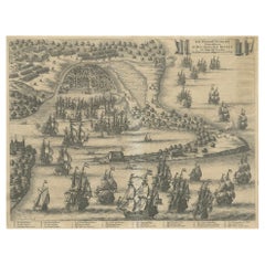
The image is an engraving titled “VEROVERINGE VAN RIO GRANDE IN BRASIL ANNO 1633.” This historical print depicts the Dutch conquest of Rio Grande in Brazil, known today as Natal, during the year 1633. The conquest took place under the command of Frederick Hendrick van Nassau, who was the Prince of Orange at that time.
The scene prominently features the Portuguese fortress situated at the mouth of the Rio Grande River, surrounded by numerous ships, likely part of the Dutch fleet involved in the conquest. The engraving shows the landscape of the region, including detailed representations of the fortifications, the river, and the surrounding terrain.
This particular print is the work of an anonymous engraver, and it was created after a depiction by Isaac Commelin or Commelijn. The print was later included in a book by Gregorio Leti titled "Teatro Belgico." Leti, born in Milan in 1630, was a noted historian and satirical writer who eventually moved to England before relocating to Amsterdam. His works included a history of the seven provinces of the Netherlands, which this engraving is part of.
The engraving was produced using etching on hand-laid (verge) paper, and it features a watermark. The print is an attractive and historically significant representation of the Dutch colonial efforts in Brazil during the early 17th century.
- Dimensions:Height: 12.01 in (30.5 cm)Width: 14.97 in (38 cm)Depth: 0 in (0.02 mm)
- Materials and Techniques:Paper,Engraved
- Period:1690-1699
- Date of Manufacture:1690
- Condition:Condition: good, given age. Folds as published. Left and right margin cut short. General age-related toning and/or occasional minor defects from handling. Study the images carefully.
- Seller Location:Langweer, NL
- Reference Number:Seller: BG-13745-11stDibs: LU3054341031812
About the Seller
5.0
Recognized Seller
These prestigious sellers are industry leaders and represent the highest echelon for item quality and design.
Platinum Seller
Premium sellers with a 4.7+ rating and 24-hour response times
Established in 2009
1stDibs seller since 2017
2,511 sales on 1stDibs
Typical response time: <1 hour
- ShippingRetrieving quote...Shipping from: Langweer, Netherlands
- Return Policy
Authenticity Guarantee
In the unlikely event there’s an issue with an item’s authenticity, contact us within 1 year for a full refund. DetailsMoney-Back Guarantee
If your item is not as described, is damaged in transit, or does not arrive, contact us within 7 days for a full refund. Details24-Hour Cancellation
You have a 24-hour grace period in which to reconsider your purchase, with no questions asked.Vetted Professional Sellers
Our world-class sellers must adhere to strict standards for service and quality, maintaining the integrity of our listings.Price-Match Guarantee
If you find that a seller listed the same item for a lower price elsewhere, we’ll match it.Trusted Global Delivery
Our best-in-class carrier network provides specialized shipping options worldwide, including custom delivery.More From This Seller
View AllCirca 1686 Daniel Stoopendaal Map: Biblical Sites from Paradise to Canaan
Located in Langweer, NL
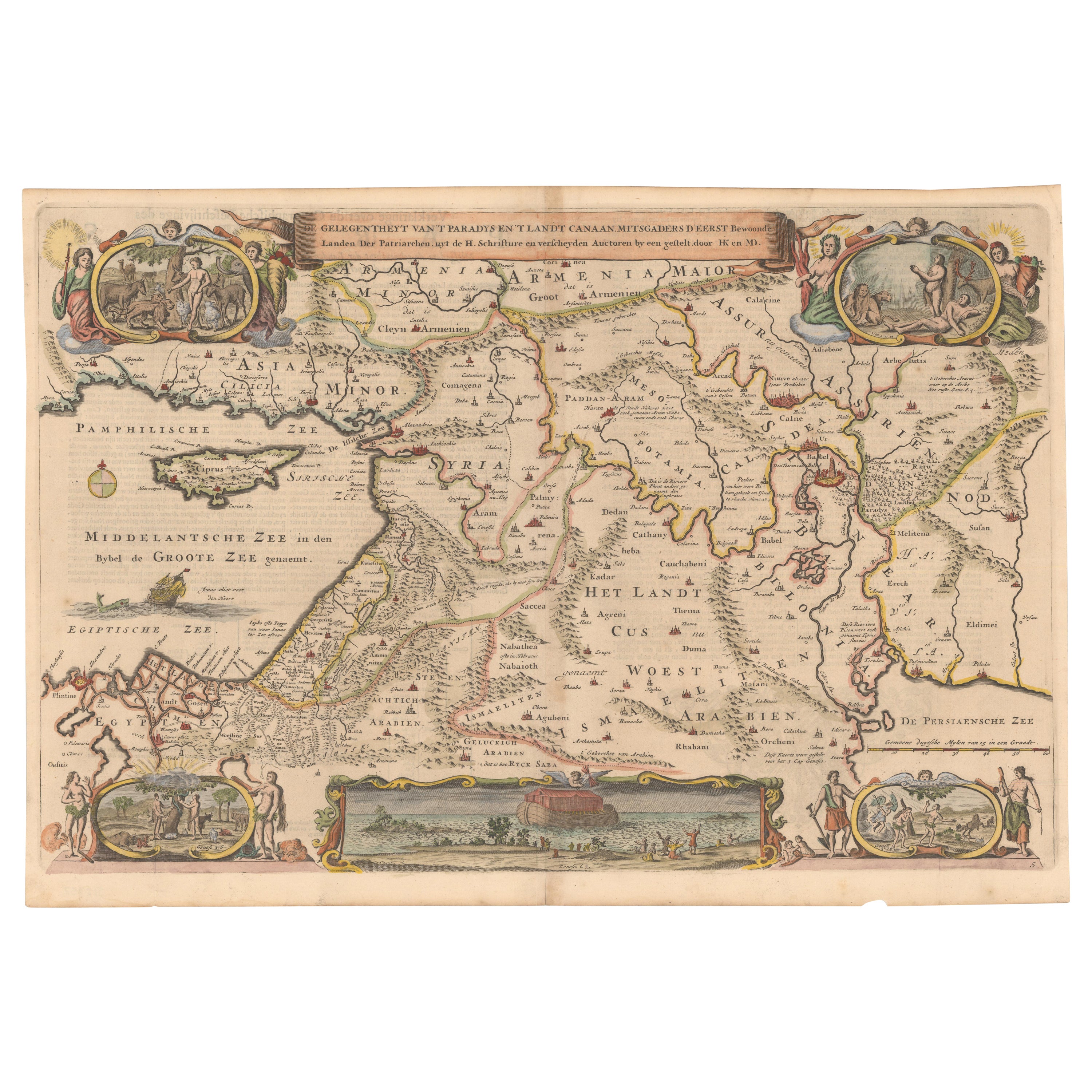
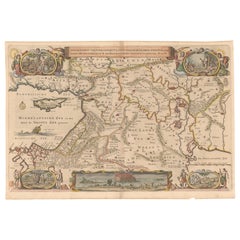
Circa 1686 Daniel Stoopendaal Map: Biblical Sites from Paradise to Canaan
This circa 1686 hand-colored map by Daniel Stoopendaal, titled "De Gelegentheyt van 't Paradys en 't Landt Canaan," beautifully illustrates the Middle East, extending from the Mediterranean to the Persian Gulf.
The map features numerous Biblical locations, such as the Garden of Eden, the wanderings of the Children of Israel, and the story of Jonas and the whale.
It is adorned with elaborate decorations, including a banner-style title cartouche and four corner vignettes depicting scenes from Genesis: Paradise, the creation of Adam and Eve, Eve offering the apple, and their expulsion from Eden.
The bottom center showcases a dramatic portrayal of Noah's Ark. Measuring 18.3 inches wide by 11.9 inches high, this first state map includes Dutch text on the reverse and is in good condition, with a crisp impression, light toning along the centerfold, and a small chip in the bottom margin.
Keywords:
- Daniel Stoopendaal map
- Biblical map
- Garden of Eden
- Land of Canaan
- Middle East historical map
- Noah's Ark map
- Adam and Eve
- 17th-century Bible...
Category
Antique 1680s Maps
Materials
Paper
$793 Sale Price
20% Off
Biblical Map of the Region from the Mediterranean through the Persian Gulf, 1720
Located in Langweer, NL
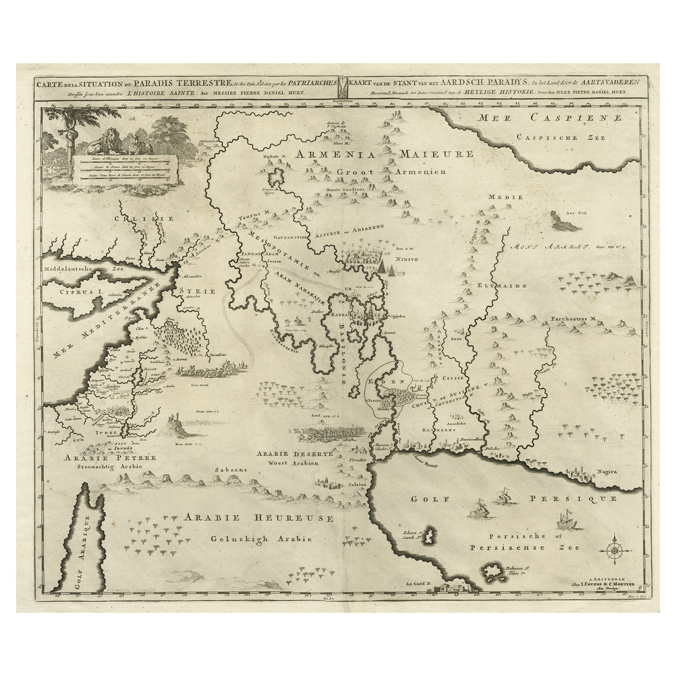
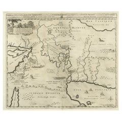
Antique map titled 'Carte de la Situation du Paradis Terrestre, Et des Pais Habitez par les Patriarches Dressee pour bien entendre l'Histoire Sainte, Par Messire Pierre Daniel Huet.'
This interesting map covers the region from the Mediterranean through the Persian Gulf. Detail is omitted in favor of Biblical depictions including the Sermon on the Mount...
Category
Antique 1720s Maps
Materials
Paper
$453 Sale Price
20% Off
Small Map of Bantam with Dutch Ships and an Engraving of Portugese, 1614
Located in Langweer, NL
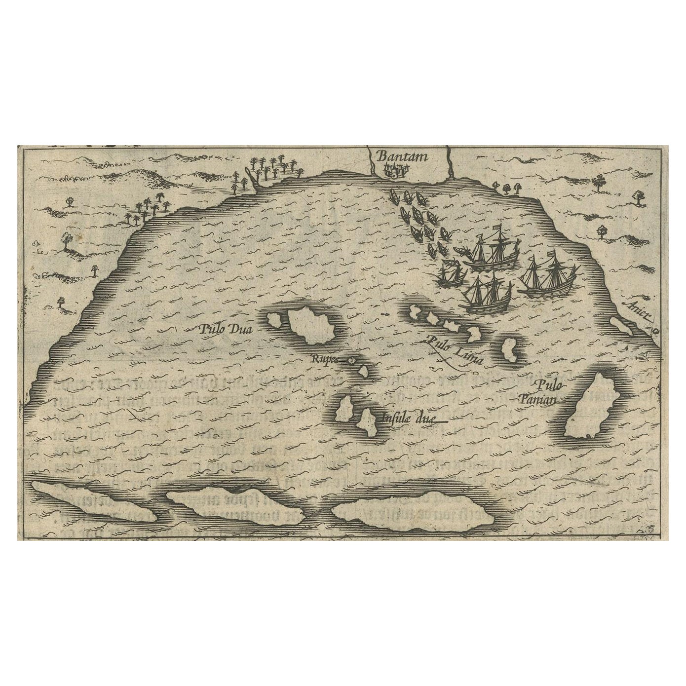
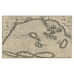
Two rare old miniature copper-engravings one one leaf. One showing the first arrival of the first Dutch in Indonesia, the so-called 'Houtman expedition' and on the reverse Portugese welcoming them with gifts.
The First Dutch Expedition to Indonesia was an expedition that took place from 1595 to 1597. It was instrumental in the opening up of the Indonesian spice trade...
Category
Antique Early 17th Century Maps
Materials
Paper
$708 Sale Price
20% Off
The Siege of Nyborg, 1659: A Strategic Battle of the Dano-Swedish War, 1746
Located in Langweer, NL
Title: "The Siege of Nyborg, 1659: A Strategic Battle of the Dano-Swedish War"
Translated text (From Dutch) on copper engraving: "The city of Nyborg captured by the lord Michiel de ...
Category
Antique 1740s Prints
Materials
Paper
$207 Sale Price
20% Off
1638 Plancius Detailed Map of Sri Lanka or Ceylon with Decorative Cartouches
Located in Langweer, NL
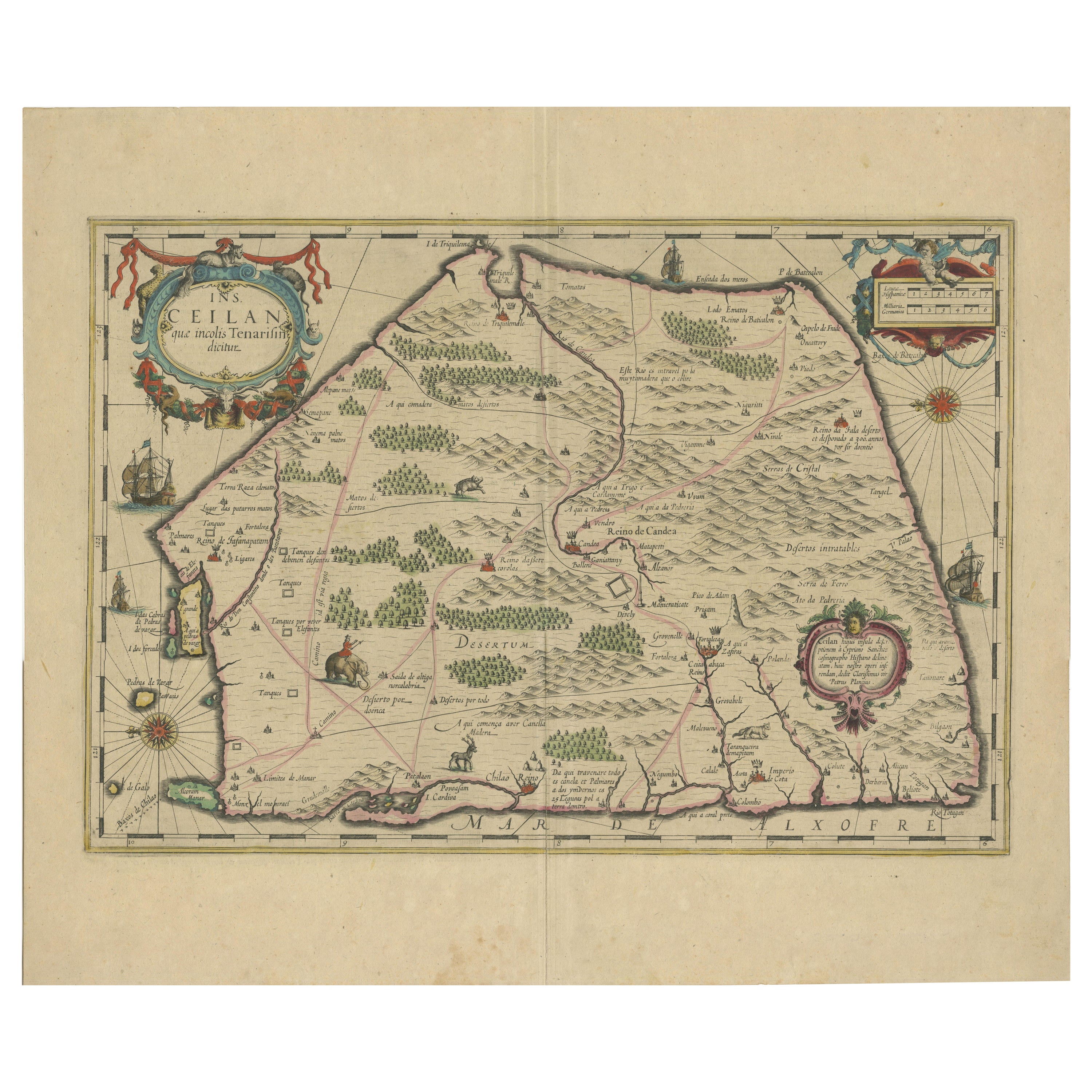
"1638 Plancius Detailed Map of Sri Lanka with Decorative Cartouches"
This beautifully detailed map of Sri Lanka, titled "Ins. Ceilan," was engraved by P. Plancius from a design by C...
Category
Antique 1630s Maps
Materials
Paper
$1,361 Sale Price
20% Off
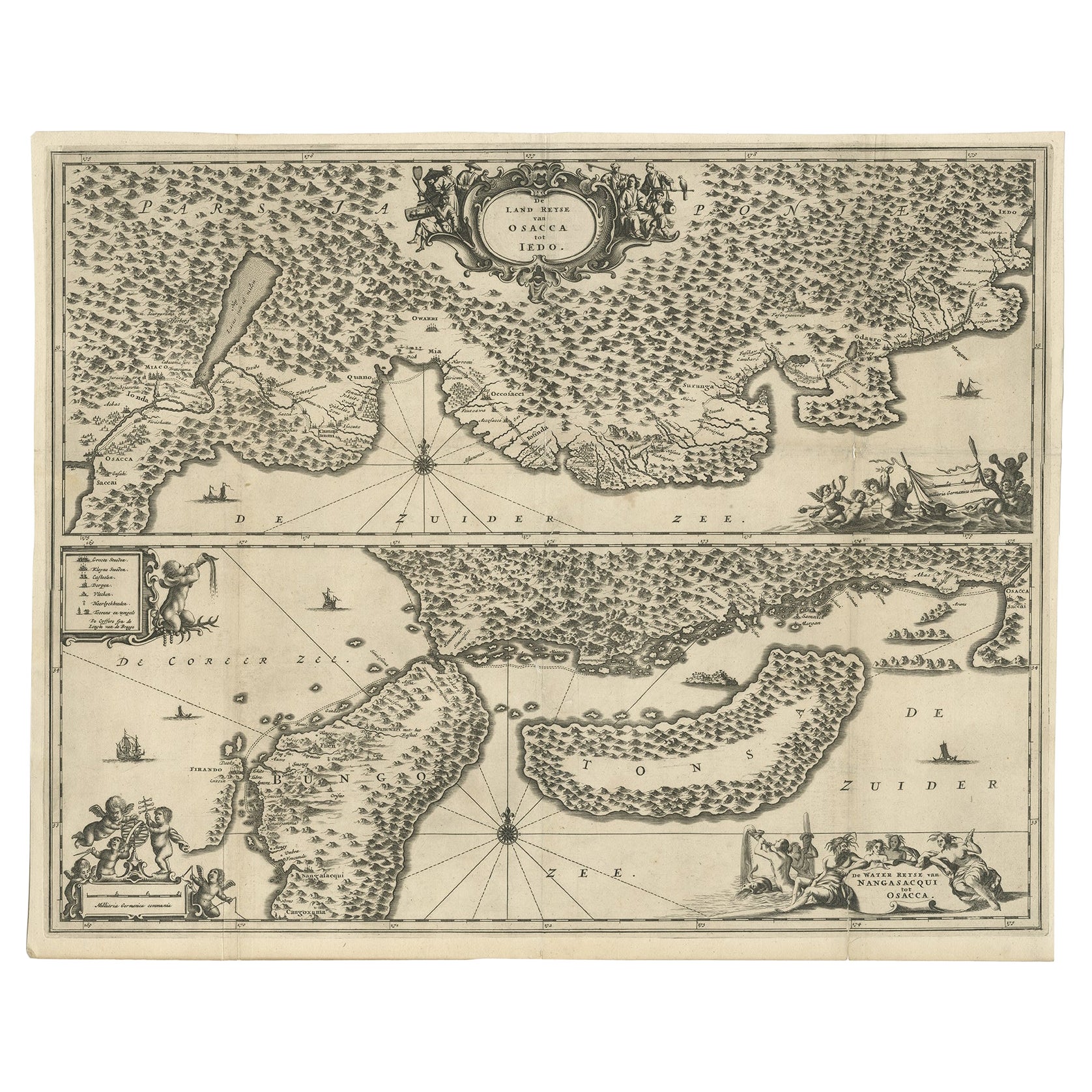
Map of Japanese Coast from Osaka to Tokyo & the Kyushu and Shikoku Islands, 1669
Located in Langweer, NL
Antique map titled 'De Land Reyse van Osacca to Iedo. De Water eyse van Nangasacqui tot Osacca.'
Two maps on one sheet. The top map shows the Japanese coast from Osaka to Tokyo (Jedo). The lower map shows the strait between mainland Japan and the two large islands...
Category
Antique 1660s Maps
Materials
Paper
$1,370 Sale Price
20% Off
You May Also Like
1597 German Map of Alexandria by Georg Braun and Frans Hogenberg
By Georg Braun and Frans Hogenberg
Located in Chapel Hill, NC
1597 Map of Alexandria by Georg Braun and Frans Hogenberg, Germany. From "Civitas Orbis Terrarum", part 2, published in Cologne by Bertram Buchholz. Printed in 2 parts. Title: "Alexa...
Category
Antique 16th Century German Renaissance Maps
Materials
Paper

1633 Map "La Souverainete De Sedan Et De Raucourt, Et La Prevoste Ric0011
Located in Norton, MA
1653 map entitled
"La Souverainete de Sedan et de Raucourt, et la Prevoste de Doncheri,"
Ric0011
Description:
Lovely map centered on Sedan and Doncheri and the Meuze River fr...
Category
Antique 17th Century Dutch Maps
Materials
Paper

1640 Flandriae Partes Duae Quarum Altera Proprietaria, Ric0016
Located in Norton, MA
1640 Willem and Joan Blaeu map entitled
"Flandriae Partes duae quarum altera Proprietaria, altera Imperialis vulgo dictur,"
Ric0016
(Mounted on Carboard)
Willem Janszoon Blaeu...
Category
Antique 17th Century Dutch Maps
Materials
Paper
17th Century Nicolas Visscher Map of Southeastern Europe
Located in Hamilton, Ontario
A beautiful, highly detailed map of southeastern Europe by Nicolas Visscher. Includes regions of Northern Italy (showing the cities Bologna, Padua, and Venice), Bohemia, Austria (sho...
Category
Antique 17th Century Dutch Maps
Materials
Paper

$1,350 Sale Price
38% Off
1643 Willem&Joan Blaeu Map NW Flanders "Flandriae Teutonicae Pars Prientalior
Located in Norton, MA
1643 Willem and Joan Blaeu map of northwest Flanders, entitled
"Flandriae Teutonicae Pars Prientalior,"
Ric0012
" Authentic" - Map of the northwest Fl...
Category
Antique 17th Century Dutch Maps
Materials
Paper

Rugen Island, Germany: An Early 17th Century Map by Mercator and Hondius
By Gerard Mercator
Located in Alamo, CA
This is an early 17th century map entitled "Nova Famigerabilis Insulae Ac Ducatus Rugiae Desciptio" (Map of Rugen Island, Germany) by Gerard Mercator and Henricus and Joducus Hondiu...
Category
Early 17th Century Old Masters Landscape Prints
Materials
Engraving

More Ways To Browse
Frederick Antique Furniture
Brazilian Colonial Furniture
Portuguese Colonial Furniture
Frederick Prince
Coffee Table Black Italian Modern
Christofle America
Iranian Silk Rug Carpet
Poul Moller
Tables With Inlaid Wood
World War Table
Antonio Jacobsen
Ariston Chairs
Coffee Tables Europe
Marble Top Dining Tables
Nordiska Argentina
Pink And Black Rug
Black Wooden Chair
Orrefors Embassy