Items Similar to Early Woodcut Map of Franconia and Surrounding Regions, 1628
Want more images or videos?
Request additional images or videos from the seller
1 of 7
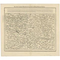
Early Woodcut Map of Franconia and Surrounding Regions, 1628
$574.75
£424.87
€480
CA$781.70
A$875.89
CHF 455.93
MX$10,715.18
NOK 5,787.25
SEK 5,465.98
DKK 3,654.96
Shipping
Retrieving quote...The 1stDibs Promise:
Authenticity Guarantee,
Money-Back Guarantee,
24-Hour Cancellation
About the Item
Title: Early Woodcut Map of Franconia and Surrounding Regions, 1628
Franconia (Franckenlande) is a region in Germany. Historically, Franconia was a significant part of the Holy Roman Empire and is now mostly located in the northern part of the modern state of Bavaria, with some parts extending into the states of Baden-Württemberg and Thuringia. The map depicts cities and towns that are part of the historical Franconia region, such as Würzburg, Bamberg, and Nuremberg, which are all located within Germany today. The Main River, which flows through Franconia, is also a key geographic feature of the region.
This early woodcut map, titled "Franckenlande am Mayn beschrieben nach aller gelegenheit / Stetten / Bergen / Waessern / Waelden und anstossenden Ländern," provides an intricate depiction of Franconia (Franckenland) and its surroundings in central Germany during the 16th century. The map captures the course of the Main River, highlighting cities, towns, mountains, forests, and rivers that define the region.
The map features dense settlements across Franconia and surrounding areas, including well-known cities like Würzburg, Bamberg, and Nuremberg, giving an insight into the region's urban distribution at the time. The detailed depiction of mountains, forests, and water bodies, illustrated in typical woodcut style, emphasizes the geographical diversity of the region. Additionally, the artistic labeling of the towns and landscapes shows the characteristic cartographic craftsmanship of the Renaissance period.
The text at the top of the map describes the geography of Franconia, mentioning the importance of the river and the fertile lands along its banks, with their abundance of resources.
Here is the translation for both text blocks:
1.
"Das edle Franckenlandt / hat einen herrlichen Fluss der Mayn genampt / der hat zween entsprung / an der Gegenseite Ficht-bergs: Der ein heißt der Weiße Mayn / rinnet von Gefrees auff Stein; Der Rote Mayn entspringt bey Pernect am anstoß des Behmer Walds."
Translation:
"The noble Franconia / has a splendid river called the Main / which has two sources / at the edge of the Fichtel Mountains: One is called the White Main / which flows from Gefrees to Stein; the Red Main springs near Bischofsgrün at the foot of the Bohemian Forest."
2.
"Der Weiß und Rote Mayn kommen zusamen zwischen Steina und Roting / fleußt demnach der ganze Mayn / durch viel trümmernde Bamberg auff Naßfurt / Schweinfurt / Kitzing / Würzburg / Gemünd / Murenburg / Franckfurt und geges Meynz in den Rhey."
Translation:
"The White and Red Main converge between Steina and Roting / then flows as the Main River / through many places including Bamberg to Naßfurt / Schweinfurt / Kitzingen / Würzburg / Gemünden / Miltenberg / Frankfurt and towards Mainz into the Rhine."
Condition report: The map is in well-preserved condition, with slight toning and minimal foxing around the edges. The woodcut lines remain sharp and clear, and the details are well-maintained, providing an excellent example of early cartographic work from the 16th century.
- Dimensions:Height: 14.45 in (36.7 cm)Width: 16.26 in (41.3 cm)Depth: 0.01 in (0.2 mm)
- Materials and Techniques:Paper,Engraved
- Period:1620-1629
- Date of Manufacture:1628
- Condition:Condition report: The map is in well-preserved condition, with slight toning and minimal foxing around the edges. The woodcut lines remain sharp and clear, and the details are well-maintained, providing an excellent example of early cartography.
- Seller Location:Langweer, NL
- Reference Number:Seller: BG-13842-101stDibs: LU3054342576142
About the Seller
5.0
Recognized Seller
These prestigious sellers are industry leaders and represent the highest echelon for item quality and design.
Platinum Seller
Premium sellers with a 4.7+ rating and 24-hour response times
Established in 2009
1stDibs seller since 2017
2,494 sales on 1stDibs
Typical response time: <1 hour
- ShippingRetrieving quote...Shipping from: Langweer, Netherlands
- Return Policy
Authenticity Guarantee
In the unlikely event there’s an issue with an item’s authenticity, contact us within 1 year for a full refund. DetailsMoney-Back Guarantee
If your item is not as described, is damaged in transit, or does not arrive, contact us within 7 days for a full refund. Details24-Hour Cancellation
You have a 24-hour grace period in which to reconsider your purchase, with no questions asked.Vetted Professional Sellers
Our world-class sellers must adhere to strict standards for service and quality, maintaining the integrity of our listings.Price-Match Guarantee
If you find that a seller listed the same item for a lower price elsewhere, we’ll match it.Trusted Global Delivery
Our best-in-class carrier network provides specialized shipping options worldwide, including custom delivery.More From This Seller
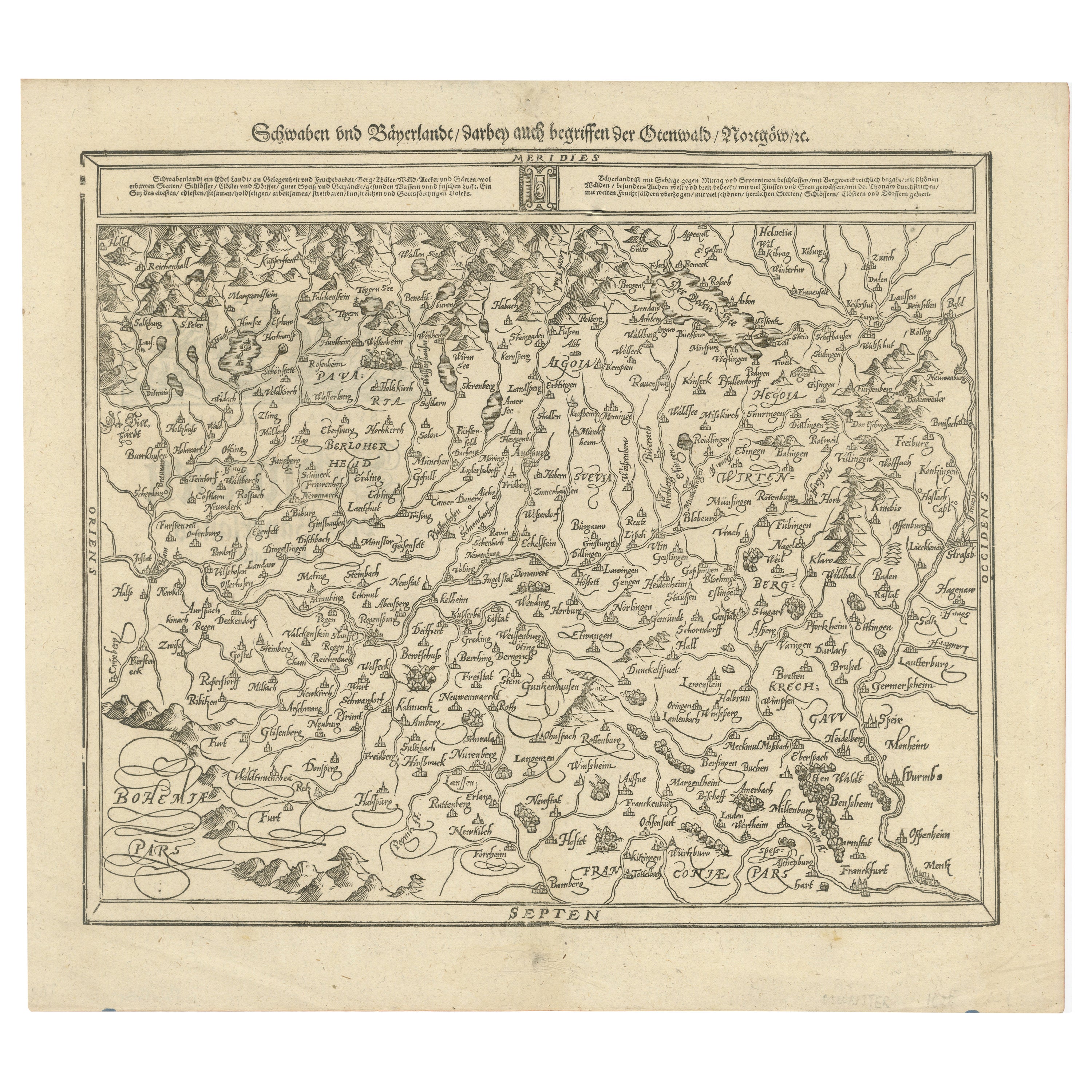
View AllEarly Woodcut Map of Swabia and Bavaria in Germany, 1628
Located in Langweer, NL
Title: Early Woodcut Map of Swabia and Bavaria, 16th Century
This early woodcut map titled "Schwaben und Bayernlande / Darbey auch begreiffen der Oenwaldt / Nordgaw / etc." provides...
Category
Antique 1620s Maps
Materials
Paper
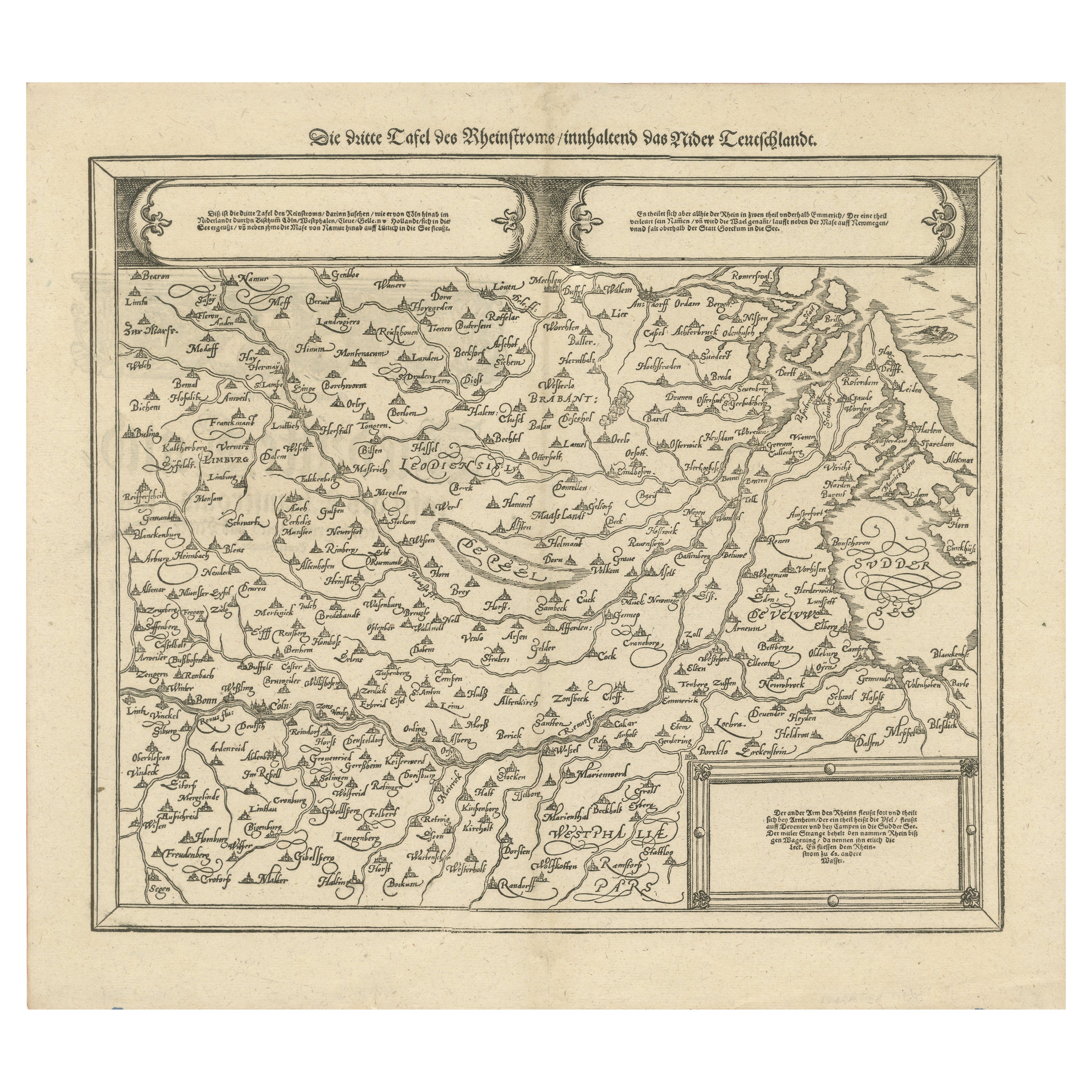
Early Woodcut Map of the Rhine River Region in Germany and Holland, circa 1628
Located in Langweer, NL
Early Woodcut Map of the Rhine River Region, "Die Dritte Tafel des Rheinstroms," ca. 16th Century
This early woodcut map, titled "Die Dritte Tafel des Rheinstroms Innhaltend das Nid...
Category
Antique 1620s Maps
Materials
Paper
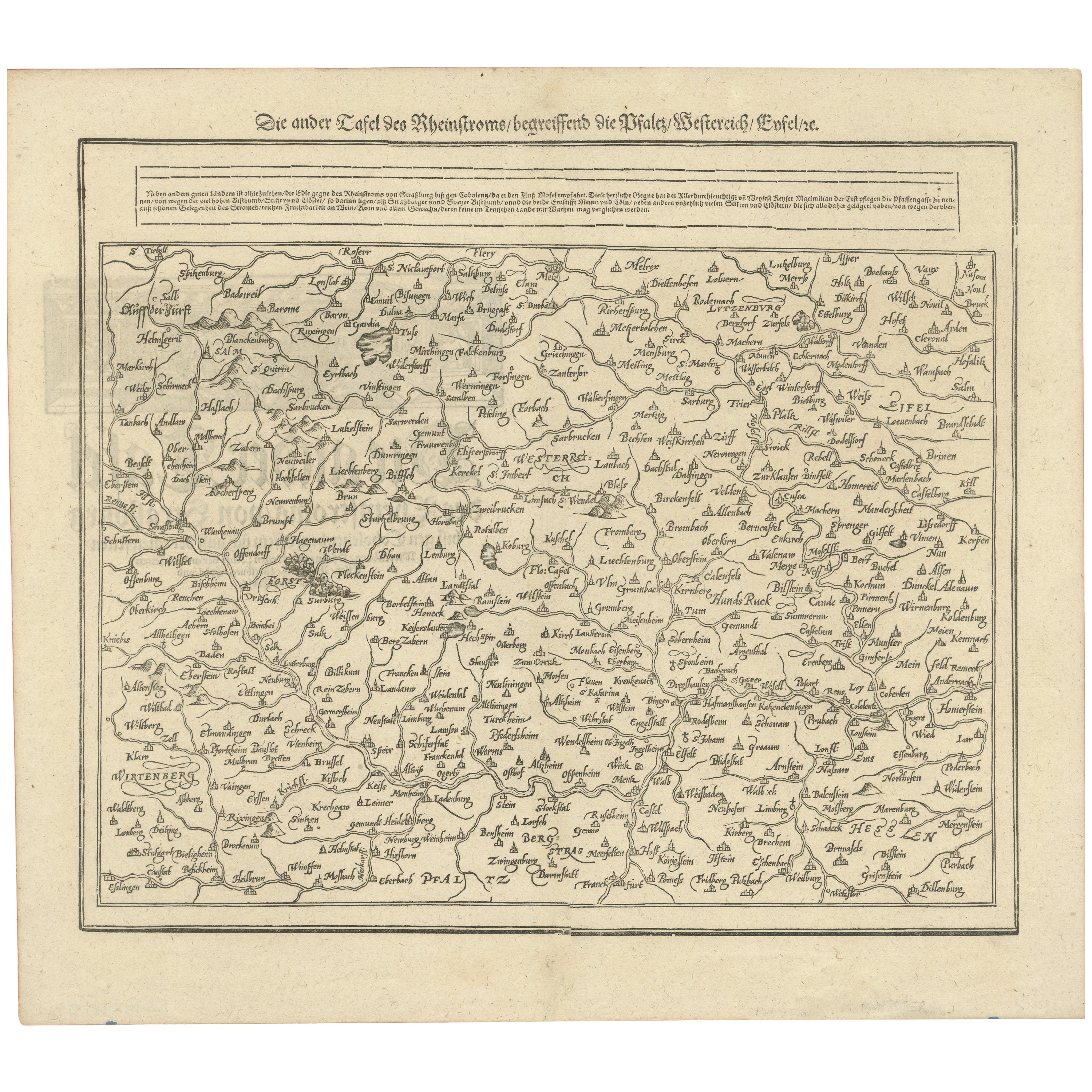
Woodcut Map of the Rhine River Region Covering the Palatinate, Austria and Elsa
Located in Langweer, NL
Early Woodcut Map of the Rhine River Region Covering the Palatinate, Austria, and Elsass, ca. 1628
This early woodcut map, titled "Die ander Tafel des Rheinstromes/begriffen die Pfa...
Category
Antique 1620s Maps
Materials
Paper
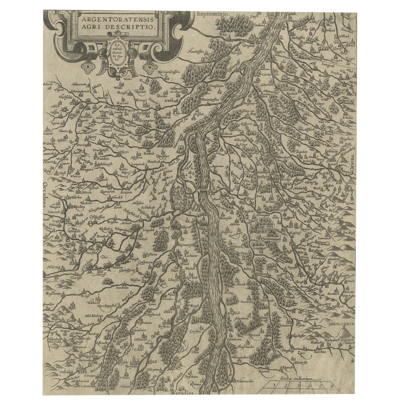
Original Antique Map of the Rhine, South and North of Strasbourg, Germany, 1608
Located in Langweer, NL
Antique map titled 'Argentoratensis agri descriptio'.
Original antique map of the Rhine, both south and north of Strasbourg, based on Daniel Specklin's three-sheet map of the Elz...
Category
Antique Early 1600s Maps
Materials
Paper
$306 Sale Price
20% Off
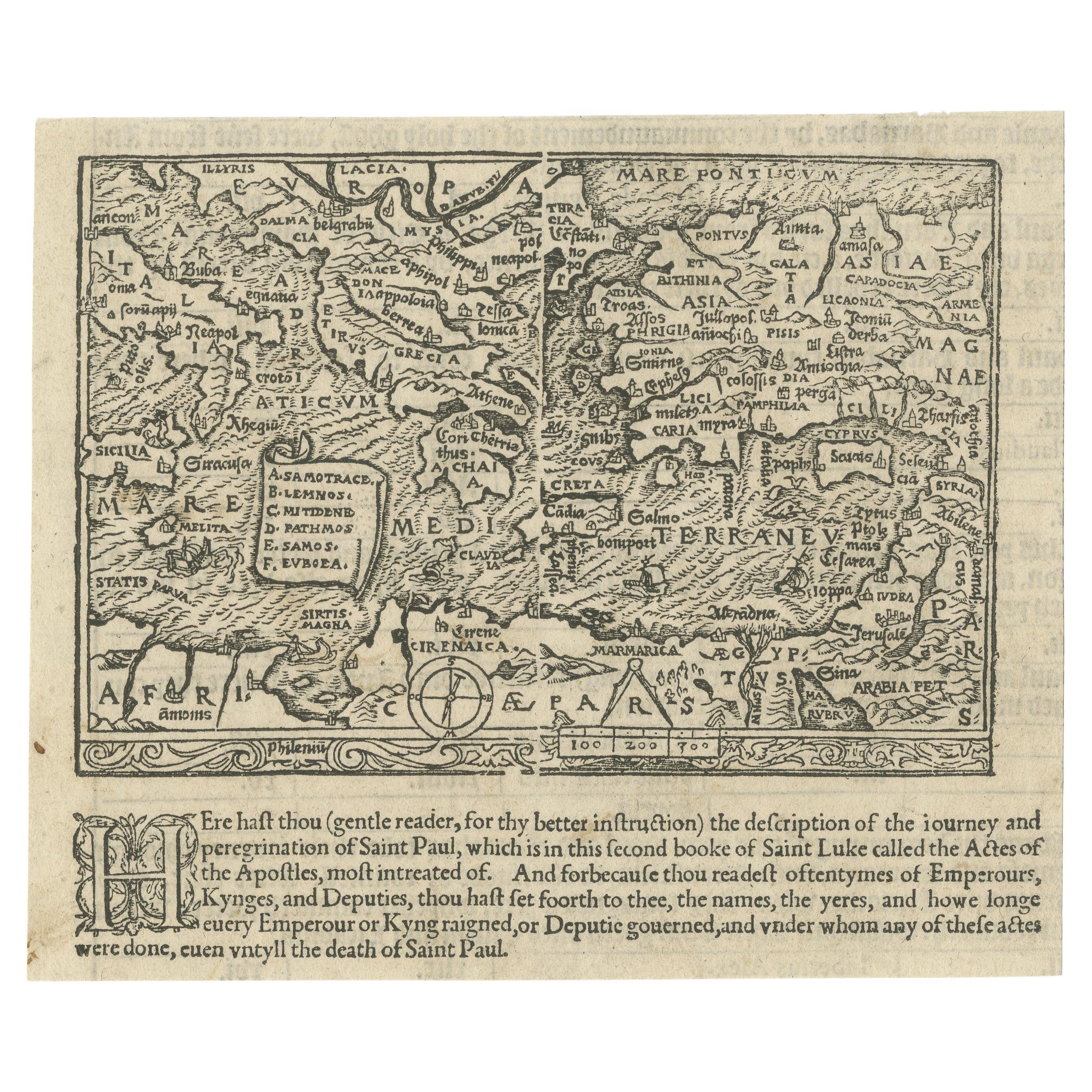
Rare and Interesting Small Antique Woodcut Map of the Mediterranean, 1568
Located in Langweer, NL
Very rare untitled antique woodcut map showing the region of the missionary journeys of Apostle Paul. It shows the Mediterranean with Greece, Asia Minor (Turkey), Northern Africa, So...
Category
Antique 16th Century Maps
Materials
Paper
$2,514 Sale Price
25% Off
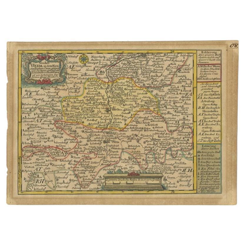
Antique Map of the Region of Weida by Schreiber, 1749
By Schreiber
Located in Langweer, NL
Antique map titled 'Das Amt Weida (..)'. Map of the region of Weida, Germany. This map originates from 'Atlas Selectus von allen Konigreichen und Landern der Welt' by Johann Georg Sc...
Category
Antique 18th Century Maps
Materials
Paper
$134 Sale Price
20% Off
You May Also Like
Engraving Depicting 16th Century Map of Terra Sancta
Located in Buchanan, MI
Abraham Ortelius (Flemish, 1527-1598) Terra Sancta.
Engraving depicting 16th century map of Terra Sancta. Site 15" x 19.5.
Category
Antique 18th Century and Earlier Maps
Materials
Paper

1592 Abraham Ortelius Map "Lorraine: Lotharingiae Nova Descripti, Ric.A005
Located in Norton, MA
1592 Abraham Ortelius map entitled
"Lorraine: Lotharingiae Nova Descripti
Ric.a005
Description: Ortelius is best known for producing the atlas from which this map comes from, "...
Category
Antique 16th Century Dutch Maps
Materials
Paper

17th Century Hand-Colored Map of a Region in West Germany by Janssonius
By Johannes Janssonius
Located in Alamo, CA
This attractive highly detailed 17th century original hand-colored map is entitled "Archiepiscopatus Maghdeburgensis et Anhaltinus Ducatus cum terris adjacentibus". It was published ...
Category
Antique Mid-17th Century Dutch Maps
Materials
Paper

1657 Janssonius Map of Vermandois and Cappelle, Ric. A-004
Located in Norton, MA
1657 Janssonius map of
Vermandois and Cappelle
Ric.a004
Description: Antique map of France titled 'Descriptio Veromanduorum - Gouvernement de la Cappelle'. Two detailed maps o...
Category
Antique 17th Century Unknown Maps
Materials
Paper

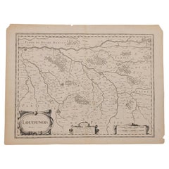
1627 Map Entitled "Loudunois, " Signed on the Back, Ric.a013
Located in Norton, MA
1627 map entitled
"Loudunois,"
Signed on the Back
Ric.a013
cartography close up double-page hand-colored elevated view no person print hand-tinted hilly close-up early 17th-...
Category
Antique 17th Century Dutch Maps
Materials
Paper
1633 Map Entitled "Beauvaisis Comitatus Belova Cium, Ric.0002
Located in Norton, MA
1633 map entitled
"Beauvaisis Comitatus Belova Cium,"
Hand Colored
Ric.0002
Description: Cartographer : - Hondius, Henricus 1587-1638
Artists and Engravers:Jodocus Hondius, one of the most notable engravers of his time. He is known for his work in association with many of the cartographers and publishers prominent at the end of the sixteenth and the beginning of the seventeenth century. A native of Flanders, he grew up in Ghent, apprenticed as an instrument and globe maker and map engraver. In 1584, to escape the religious troubles sweeping the Low Countries at that time, he fled to London where he spent some years before finally settling in Amsterdam about 1593. In the London period he came into contact with the leading scientists and geographers of the day and engraved maps in The Mariner\\\\\\\\\\\\\\\'s Mirrour, the English edition of Waghenaer\\\\\\\\\\\\\\\'s Sea Atlas, as well as others with Pieter van den Keere, his brother-in-law. No doubt his temporary exile in London stood him in good stead, earning him an international reputation, for it could have been no accident that Speed chose Hondius to engrave the plates for the maps in The Theatre of the Empire of Great Britaine in the years between 1605 and 1610. In 1604 Hondius bought the plates of Mercator\\\\\\\\\\\\\\\'s Atlas which, in spite of its excellence, had not competed successfully with the continuing demand for the Ortelius Theatrum Orbis Terrarum. To meet this competition Hondius added about 40 maps to Mercator\\\\\\\\\\\\\\\'s original number and from 1606 published enlarged editions in many languages, still under Mercator\\\\\\\\\\\\\\\'s name but with his own name as publisher. These atlases have become known as the Mercator/Hondius series. The following year the maps were reengraved in miniature form and issued as a pocket Atlas Minor. After the death of Jodocus Hondius the Elder in 1612, work on the two atlases, folio and miniature, was carried on by his widow and sons, Jodocus II and Henricus, and eventually in conjunction with Jan Jansson in Amsterdam.
In all, from 1606 onwards, nearly 50 editions with increasing numbers of maps with texts in the main European languages were printed. Summaries of these issues are given under the entry for Gerard Mercator. Jodocus Hondius the Elder * 1588 Maps in The Mariner\\\\\\\\\\\\\\\'s Mirrour (Waghenaer/Ashley) * 1590 World Map...
Category
Antique 17th Century Dutch Maps
Materials
Paper

More Ways To Browse
German Wurttemberg
Bohemian Engraved
Antique Steins
Antique German Stein
Antique Hat Block
Elios Chair
Plata Lappas
Red Retro Dining Set
Antique Bouquet
Antique Silver Glasses Case
Carlo Scarpa 1934 Chairs
Christofle Marly
1900 Antique Chairs
Glass Table Italian Round
Mid Century Colonial
Alvar Aalto Poster
Geometric Metal Table
Post Modern High Chairs