Items Similar to Framed Mid-19th Century Wall Map of Long Island, the Hamptons

Want more images or videos?
Request additional images or videos from the seller
1 of 12
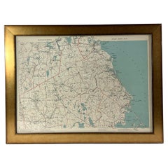
Framed Mid-19th Century Wall Map of Long Island, the Hamptons
$7,100
$8,87520% Off
£5,390.20
£6,737.7520% Off
€6,165.24
€7,706.5520% Off
CA$9,919.73
CA$12,399.6620% Off
A$11,032.90
A$13,791.1320% Off
CHF 5,761.04
CHF 7,201.3020% Off
MX$134,258.71
MX$167,823.3920% Off
NOK 73,577.27
NOK 91,971.5920% Off
SEK 69,002.50
SEK 86,253.1320% Off
DKK 46,013.53
DKK 57,516.9120% Off
Shipping
Retrieving quote...The 1stDibs Promise:
Authenticity Guarantee,
Money-Back Guarantee,
24-Hour Cancellation
About the Item
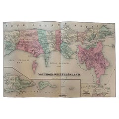
A Framed museum quality find. This large wall map dates to the mid-1800s. Detailed inset maps of, Sag Harbor, East Hampton, Amagansett, Shelter Island and most villages in Long Island. It also has agriculture stats for 1855. Detailed prints of homes on Scuttle Hole in Bridgehampton as well as several other detailed prints. Lists of businesses, distance tables and railroad schedules and stops. The total amount of detailed information about Suffolk County Long Island is staggering. A unique rare New York map. Bridgehampton, Montauk, Greenport
- Dimensions:Height: 51.5 in (130.81 cm)Width: 63 in (160.02 cm)Depth: 1 in (2.54 cm)
- Materials and Techniques:
- Place of Origin:
- Period:
- Date of Manufacture:circa 1855
- Condition:Wear consistent with age and use. some is some professional restoration on portions of the map. You can see in detailed images.
- Seller Location:Sag Harbor, NY
- Reference Number:Seller: B0081stDibs: LU2252339207132
About the Seller
5.0
Vetted Professional Seller
Every seller passes strict standards for authenticity and reliability
Established in 2006
1stDibs seller since 2016
106 sales on 1stDibs
Typical response time: 1 hour
- ShippingRetrieving quote...Shipping from: Sag Harbor, NY
- Return Policy
Authenticity Guarantee
In the unlikely event there’s an issue with an item’s authenticity, contact us within 1 year for a full refund. DetailsMoney-Back Guarantee
If your item is not as described, is damaged in transit, or does not arrive, contact us within 7 days for a full refund. Details24-Hour Cancellation
You have a 24-hour grace period in which to reconsider your purchase, with no questions asked.Vetted Professional Sellers
Our world-class sellers must adhere to strict standards for service and quality, maintaining the integrity of our listings.Price-Match Guarantee
If you find that a seller listed the same item for a lower price elsewhere, we’ll match it.Trusted Global Delivery
Our best-in-class carrier network provides specialized shipping options worldwide, including custom delivery.More From This Seller
View AllAntique Map Long Island, Southold, Shelter Island, Orient, New York
By Beers Atlas Co.
Located in Sag Harbor, NY
Antique map of Long Island, Southold, Shelter Island, Orient, Great details, Names of homes, Roads and Businesses in 1870. Unframed. This is...
Category
Antique Mid-19th Century American Early Victorian Prints
Materials
Paper
$1,180 Sale Price
20% Off
Free Shipping
"Long Island Sailing Grounds" Watercolor by Cappy Hjalmar Amundson
By Cappy
Located in Sag Harbor, NY
This is a unique Water color by the famed nautical painter C. Hjalmar Amundson. Born to the name Casper Hjalmar Emerson III, later changed to C. Hjalmar Amundson, he was only ever r...
Category
Mid-20th Century American American Classical Paintings
Materials
Paper
Sag Harbor Whale Scrimshaw Cribbage Board
Located in Sag Harbor, NY
Authentic Scrimshaw carved into and antique tortoise shell with brass legs. Carved aboard the Ship Argonaut. A whaling ship from Sag Harbor New York from 1814-1832. The detailed carv...
Category
Antique Early 19th Century American Folk Art Antiquities
Materials
Tortoise Shell
$9,012 Sale Price
30% Off
Signed Original George Henry Hall Oil Painting
By George Henry Hall
Located in Sag Harbor, NY
American Artist George Henry Hall was born on September 21, 1825 in Boston, Massachusetts. Hall opened a studio in New York City in 1852. The Smithsonian deems him to be "one of the ...
Category
Antique 1860s Spanish Paintings
Materials
Canvas

$3,750 Sale Price
45% Off
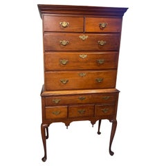
American Highboy Chest of Drawers
Located in Sag Harbor, NY
This is a special piece. Solid cherry wood exterior with solid poplar interior. Dowel construction on the entire casing. Each of the 9 drawers has dovetail construction on both the f...
Category
Antique Late 19th Century American American Colonial Commodes and Chests...
Materials
Cherry
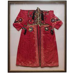
19th Century, Silk Bordered Caftan
Located in Sag Harbor, NY
Amazing silk North African caftan, hand-stitched beautiful embroidered details. Framed in a large shadow box, this piece is a visual treat.
Category
Antique Late 19th Century Moroccan Shadow Boxes
You May Also Like
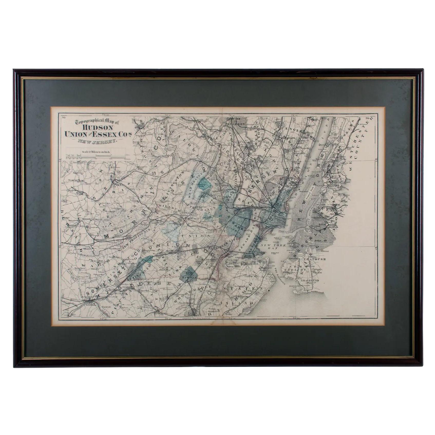
1872 Map of Hudson, Union and Essex Counties, New Jersey
Located in Savannah, GA
A hand-colored topographical map of New Jersey’s Hudson, Union and Essex Counties from the Atlas of New Jersey by F.W. Beers, published in 1872.
sight 15 by 22½ inches
frame 20 by...
Category
Antique 1870s American Prints
Materials
Glass, Wood, Paper

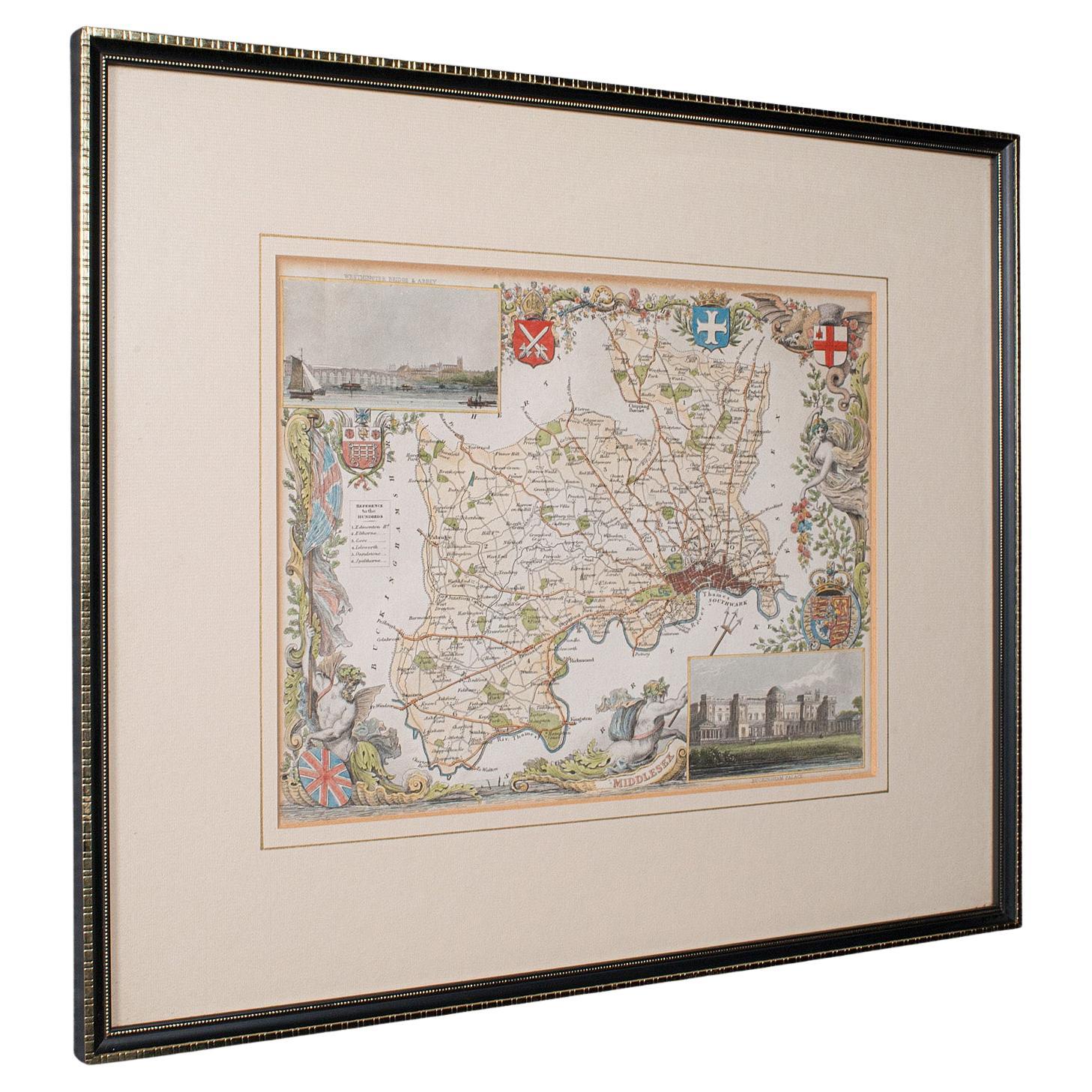
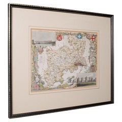
Antique County Map, Middlesex, English, Framed, Litho, Cartography, Victorian
Located in Hele, Devon, GB
This is an antique lithography map of Middlesex. An English, framed atlas engraving of cartographic interest, dating to the mid 19th century and later.
Superb lithography of Middle...
Category
Antique Mid-19th Century British Victorian Maps
Materials
Paper
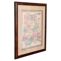
A vintage map of Fairfield Connecticut, framed in burlwood, early 20th century
Located in View Park, CA
An antique map featuring Fairfield, Connecticut, framed in rich burlwood, behind glass and ready to hang, early to mid 20th century. Featuring tones of rose, butter, and mint - a lov...
Category
Early 20th Century American American Classical Decorative Art
Materials
Glass, Burl, Paper
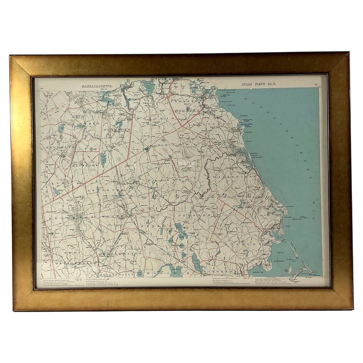
1891 Map of South Shore of Boston
Located in Norwell, MA
Original 1891 map showing Cohasset, Scituate, Marshfield, Duxbury, Kingston, Norwell, Hanover, Hingham, Hull, Holbrook, Weymouth, Hanson, Pembroke, etc. Framed with glass. Circa 1891.
Category
Antique 1890s North American Prints
Materials
Paper
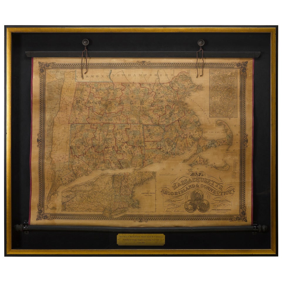
1854 Map of Massachusetts, Connecticut and Rhode Island, Antique Wall Map
Located in Colorado Springs, CO
This striking wall map was published in 1854 by Ensign, Bridgman & Fanning and has both full original hand-coloring and original hardware. This impression is both informative and highly decorative.
The states are divided into counties, outlined in red, green, and black, and subdivided into towns. Roads, canals, and railroad lines are prominently depicted, although they are not all labeled. The mapmakers also marked lighthouses, banks, churches, and prominent buildings, with a key at right. The map is an informative and comprehensive overview of the infrastructural development of New England prior to the Civil War. Physical geographies depicted include elevation, conveyed with hachure marks, rivers and lakes. The impression features an inset map of Boston...
Category
Antique 19th Century American Maps
Materials
Paper

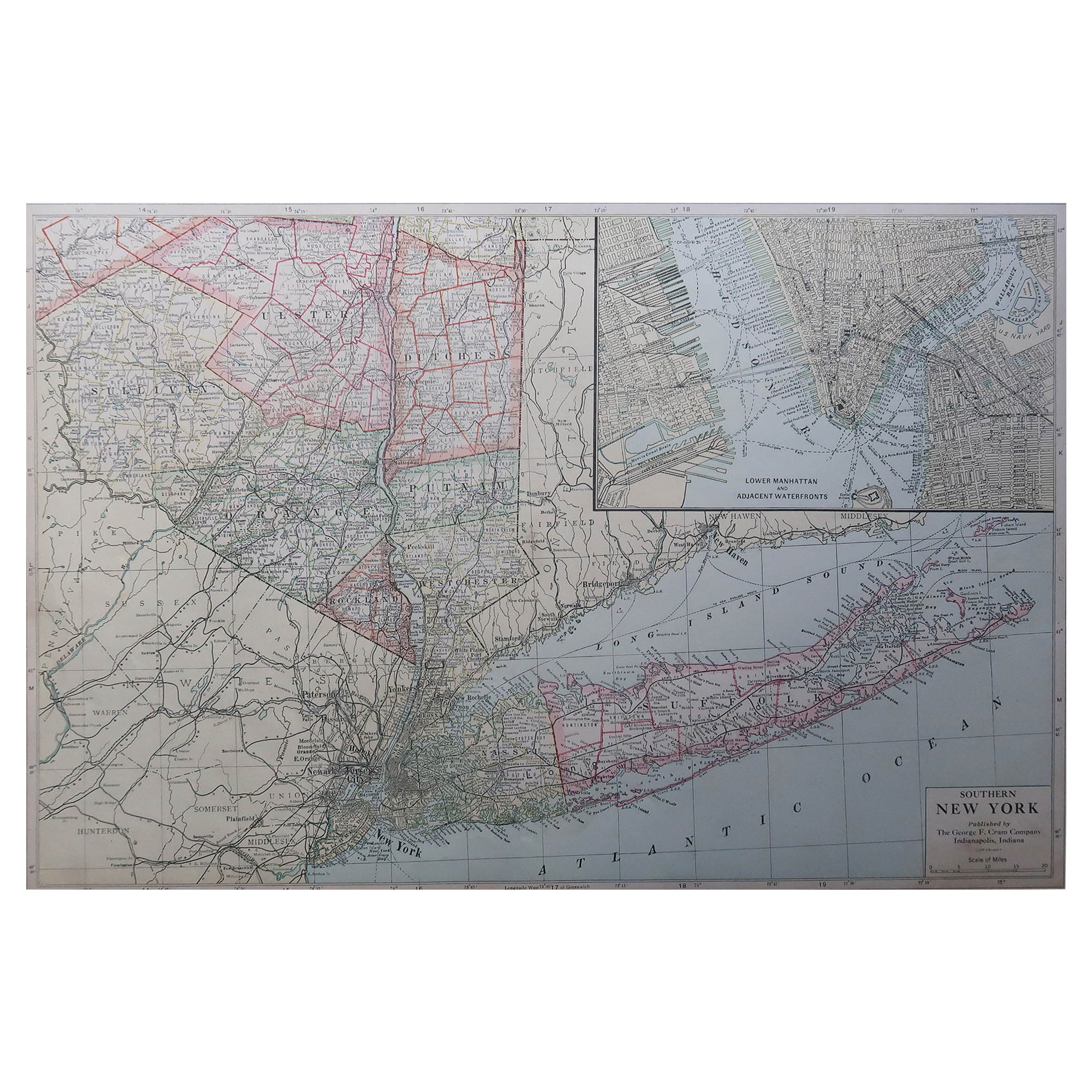
Large Original Antique Map of New York State( Southern ), USA, C.1900
Located in St Annes, Lancashire
Fabulous map of Southern New York . With a vignette of Lower Manhattan
Original color.
Engraved and printed by the George F. Cram Company, Indianapolis.
Published, C.1900.
Unfram...
Category
Antique 1890s American Maps
Materials
Paper

More Ways To Browse
Long Island Used Furniture
Large Wall Maps
Railroad Table
Montauk Furniture
Antique Oushak Carpets
Blue Coffee Tables
1945 Chair Juhl
Antique Three Leg Table
Folke Arstrom
Silver Over Copper
Vintage Barware Glasses
Antique Etched Glass
Antique French Shell
Coffee Table Black Italian Modern
Christofle America
Iranian Silk Rug Carpet
Poul Moller
Tables With Inlaid Wood