Items Similar to Friesland, Groningen and Overijssel – Rare Woodcut Map by Münster, c. 1550

Want more images or videos?
Request additional images or videos from the seller
1 of 10
Friesland, Groningen and Overijssel – Rare Woodcut Map by Münster, c. 1550
$542.48
£406.06
€460
CA$746.61
A$832.17
CHF 436.61
MX$10,162.20
NOK 5,528.47
SEK 5,225.25
DKK 3,501.84
About the Item
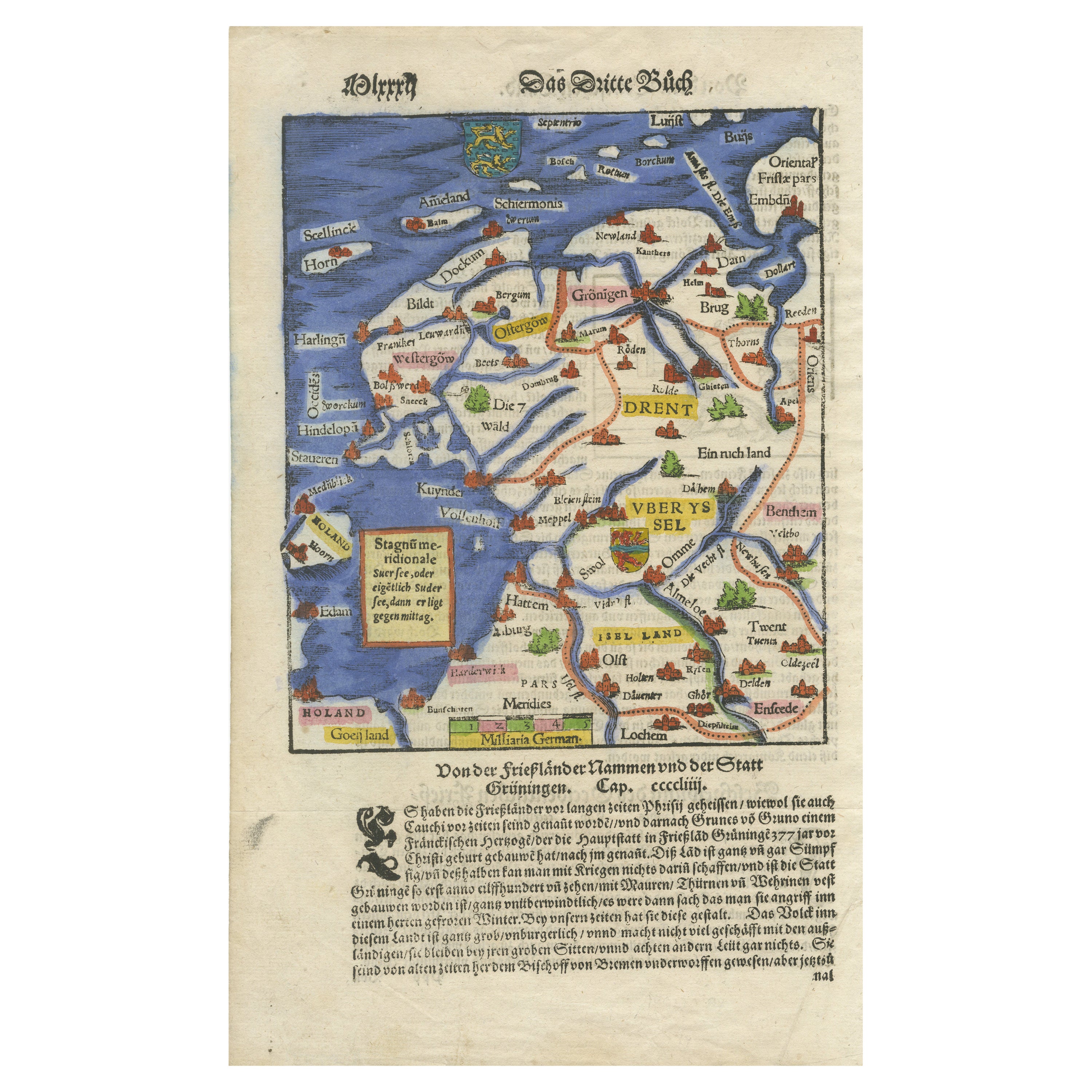
Frisia, Groningen and Overijssel – Rare Woodcut Map by Münster, c. 1550, Germany
This highly decorative 16th-century woodcut map titled “Von dem Teutschen Land: Seelentfrie” was published by Sebastian Münster, one of the most important cartographers of the early modern period. Issued around 1550 in a German edition of his monumental Cosmographia, this rare and beautifully hand-colored map presents the northern provinces of the Low Countries — particularly Frisia (Friesland), Groningen, and Overijssel — during the Renaissance era.
Münster’s map is full of historical charm and typographic richness. It showcases the region’s principal towns, rivers, and settlements in a highly stylized manner, with red-roofed pictorial representations of cities such as Leeuwarden (Lewwardia), Groningen, Kampen, Zwolle, Meppel, **Deventer**, Enschede, and many others. The Zuiderzeef is clearly delineated to the west, along with parts of Holland and Gelderland.
The woodcut cartography is surrounded by hand-applied watercolors in yellow, green, pink, and blue, enhancing both the topography and territorial boundaries. At the bottom of the image is a block of German Fraktur typeface, describing the customs, economy, and terrain of the region. It remarks on the harshness of the land, the robustness of the people, and its strategic but rugged nature, reflecting contemporary geopolitical concerns and ethnographic curiosity.
Münster’s Cosmographia (first published in 1544) was the most widely circulated world description of the 16th century, reprinted in over 30 editions and translated into several languages. This map stands out not only for its early depiction of northern Netherlands geography but also for its remarkable graphic style and early use of color.
Cartographer:*Sebastian Münster
Date: circa 1550
Publication: *Cosmographia Universalis* (German edition)
Technique: Woodcut with period hand-coloring
Language: German (Fraktur script)
Condition report:
Good condition for age. Clean hand-coloring, light toning, some minor margin wear. Verso with printed German text. No tears or restorations.
Framing suggestion:
Present this piece in a dark walnut or oak frame with an off-white, archival-quality mat. A float mount showing the full sheet, including the lower text block and margins, will enhance both its historical and decorative appeal.
- Dimensions:Height: 11.82 in (30 cm)Width: 7.64 in (19.4 cm)Depth: 0.01 in (0.2 mm)
- Materials and Techniques:Paper,Engraved
- Period:
- Date of Manufacture:circa 1550
- Condition:Good condition for age. Clean hand-coloring, light toning, some minor margin wear. Verso with printed German text. No tears or restorations.
- Seller Location:Langweer, NL
- Reference Number:Seller: BG-027871stDibs: LU3054344979112
About the Seller
5.0
Recognized Seller
These prestigious sellers are industry leaders and represent the highest echelon for item quality and design.
Platinum Seller
Premium sellers with a 4.7+ rating and 24-hour response times
Established in 2009
1stDibs seller since 2017
2,513 sales on 1stDibs
Typical response time: <1 hour
- ShippingRetrieving quote...Shipping from: Langweer, Netherlands
- Return Policy
Authenticity Guarantee
In the unlikely event there’s an issue with an item’s authenticity, contact us within 1 year for a full refund. DetailsMoney-Back Guarantee
If your item is not as described, is damaged in transit, or does not arrive, contact us within 7 days for a full refund. Details24-Hour Cancellation
You have a 24-hour grace period in which to reconsider your purchase, with no questions asked.Vetted Professional Sellers
Our world-class sellers must adhere to strict standards for service and quality, maintaining the integrity of our listings.Price-Match Guarantee
If you find that a seller listed the same item for a lower price elsewhere, we’ll match it.Trusted Global Delivery
Our best-in-class carrier network provides specialized shipping options worldwide, including custom delivery.More From This Seller
View AllFriesland, Groningen, Drenthe, Overijssel – Antique Map by Seb. Münster, 1574
Located in Langweer, NL
Friesland, Groningen, Drenthe, Overijssel – Antique Map by Sebastian Münster, 1574
This rare and finely colored woodcut map of Northern Netherlands depicts the provinces of Friesl...
Category
Antique 16th Century Maps
Materials
Paper

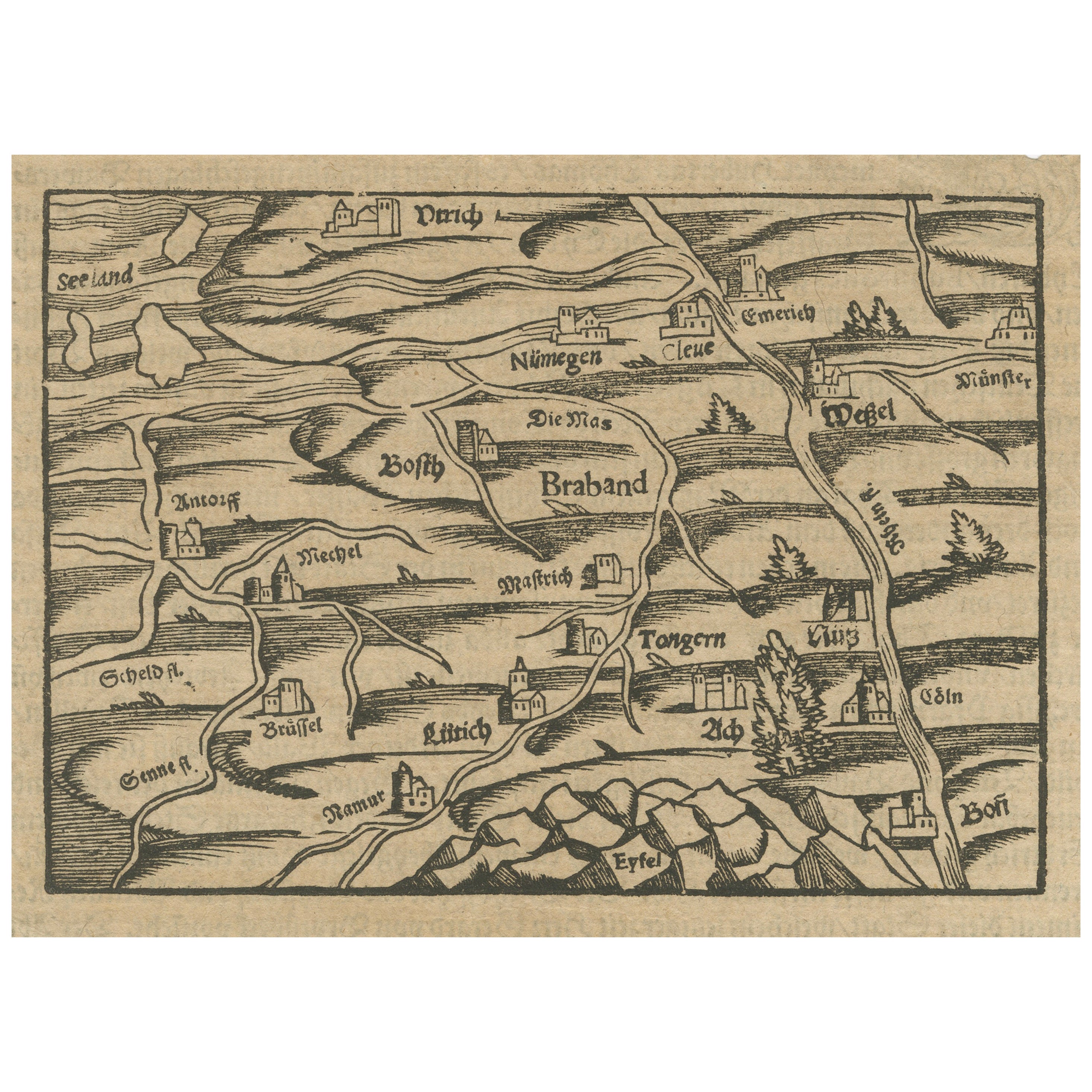
Rare 16th Century Woodcut Map of Brabant and the Rhine Valley, circa 1549
Located in Langweer, NL
Title: Rare 16th Century Woodcut Map of Brabant and the Rhine Valley, circa 1550
Description:
This rare and highly decorative early woodcut map depicts the region of Brabant and the...
Category
Antique 16th Century German Maps
Materials
Paper
Old Antique Map of the Province of Friesland, the Netherlands, c.1580
Located in Langweer, NL
Antique map titled 'Frisia Occidentalis'. Old map of the province of Friesland, the Netherlands. This map is also known as the 'Pauwenkaart' ('peacock map'), referring to the peacock next to the inset map. Based on a manuscript map...
Category
Antique 16th Century Maps
Materials
Paper
$896 Sale Price
20% Off
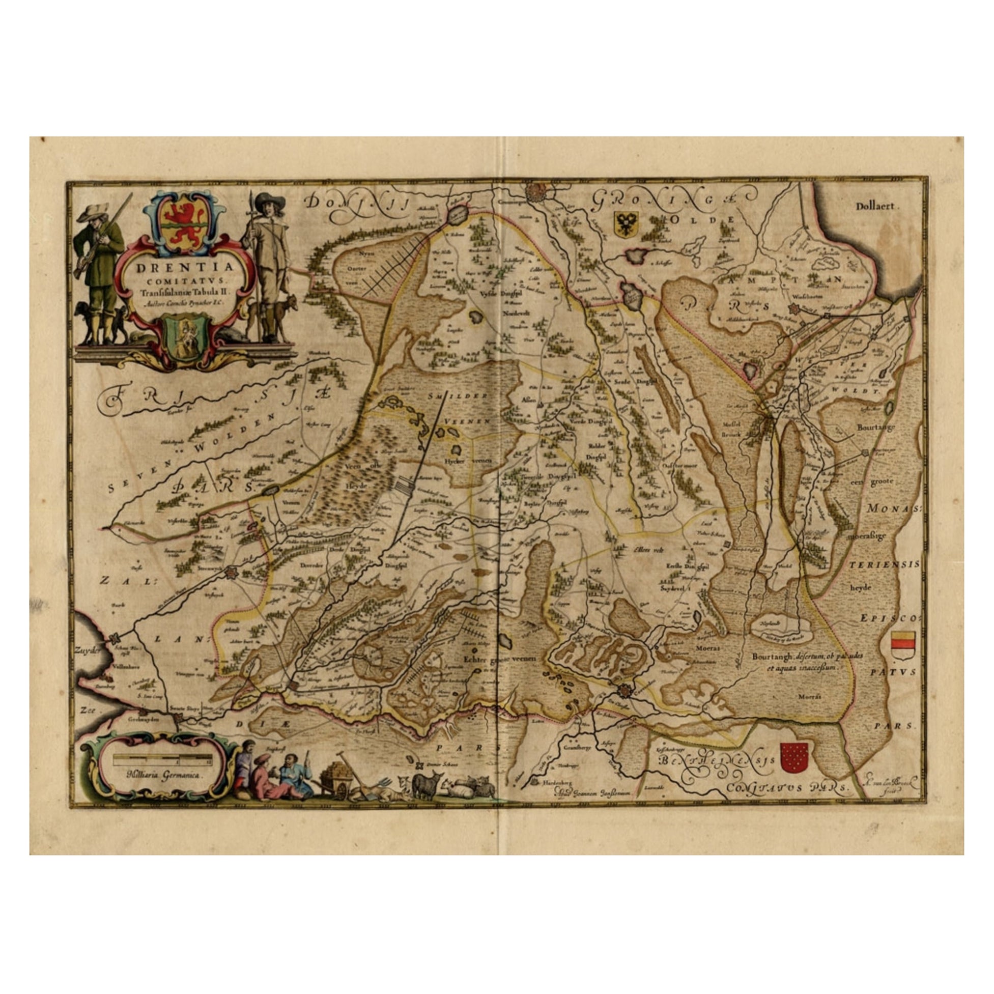
Antique Map of Drenthe, a Province in The Netherlands, 1658
Located in Langweer, NL
Antique map titled 'Drentia comitatus (..)'. Copper engraved contemp. hand coloured map of Drenthe, a province in the Netherlands. Large cartouche with coats of arms. This map is mad...
Category
Antique 17th Century Maps
Materials
Paper

$613 Sale Price
20% Off
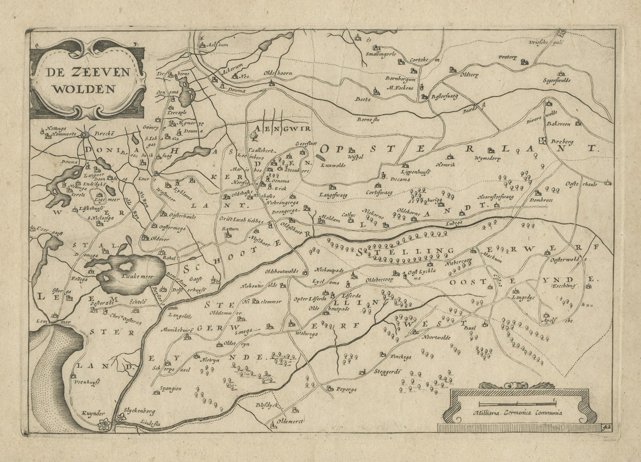
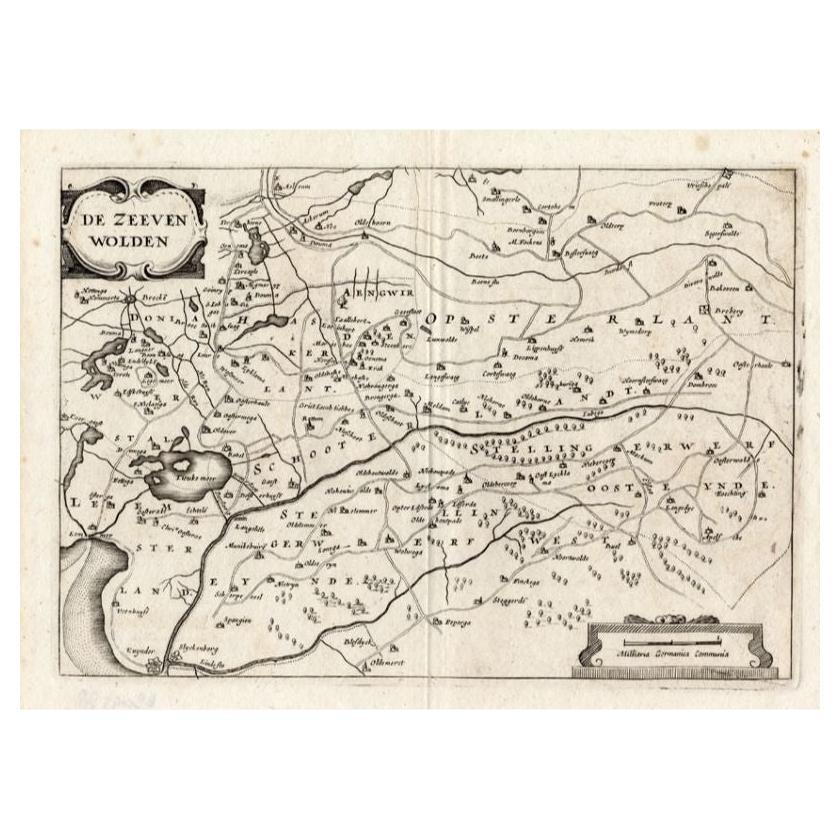
Antique Map of the Region of Zevenwouden, Friesland, The Netherlands, 1660
Located in Langweer, NL
Antique map titled 'De Zeeven Wolden'. Map of the region of Zevenwouden (or Zevenwolden) in Friesland, the Netherlands.
This region include the villages of Langweer, Echtenerbrug...
Category
Antique 17th Century Maps
Materials
Paper
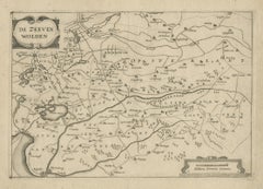
Antique Map of the Region of Zevenwouden in Friesland, The Netherlands, 1635
Located in Langweer, NL
Antique map titled 'De Zeeven Wolden'. Map of the region of Zevenwouden (or Zevenwolden) in Friesland, the Netherlands. This region include the villages of Langweer, Echtenerbrug, Le...
Category
Antique 17th Century Maps
Materials
Paper

$330 Sale Price
20% Off
You May Also Like
Map of the Netherlands - Etching by G. Braun and F. Hogenberg -Late 16th Century
By Franz Hogenberg
Located in Roma, IT
Map of the Netherlands is an original etching realized by George Braun and Franz Hogenberg, as part of the "Civitates Orbis Terrarum".
The “Civitates Orbis Terrarum” (Atlas of Citi...
Category
16th Century Figurative Prints
Materials
Etching

Map of Dordrecht - Etching by G. Braun/F. Hogenberg - Late 16th Century
Located in Roma, IT
Map od Dordrecht is an artwork realized by Braun and Hogemberg in the late 16th century.
Hand watercolored etching.
40x54 cm.
Good conditions.
Braun Hoghemberg (1541-1622) was a ...
Category
16th Century Old Masters Figurative Prints
Materials
Etching

Map of Nijmegen - Etching by G. Braun and F. Hogenberg - Late 16th Century
By Franz Hogenberg
Located in Roma, IT
This map of Noviomagvs is an original etching realized by Georg Braun and Franz Hogenberg as part of the famous series "Civitates Orbis Terrarum".
The state of preservation of the ...
Category
16th Century Figurative Prints
Materials
Etching

North Holland, Netherlands: A Large 17th C. Hand-colored Map by Sanson & Jaillot
By Nicholas Sanson d'Abbeville
Located in Alamo, CA
This large hand-colored map entitled "Le Comte De Hollande Dressee sur les Memoires les plus Nouveaux" was originally created by Nicholas Sanson d'Abbeville. This version was publish...
Category
1690s Landscape Prints
Materials
Engraving

Utrecht, Antique Map from "Civitates Orbis Terrarum"
By Franz Hogenberg
Located in Roma, IT
Braun G., Hogenberg F., Traiectum or Utrecht, from the collection Civitates Orbis Terrarum, Cologne, T. Graminaeus, 1572-1617.
Very fine B/W aquatint showing a view of Utrecht, with...
Category
16th Century Landscape Prints
Materials
Etching

Map of Kampen, Netherlands - by G. Braun and F. Hogenberg - Late 16th Century
By Franz Hogenberg
Located in Roma, IT
This map of Kampen (the ancient Campensis) is an original etching realized by George Braun and Franz Hogenberg as part of the famous Series "Civitates Orbis Terrarum".
The “Civita...
Category
16th Century Figurative Prints
Materials
Etching

More Ways To Browse
Cosmographia Universalis
Silver Bowl Large
Down Couch
Used Lighter Art
Blue Edge Glass
Mahogany 1950s Furniture
Solid Mahogany Table
Dessert Glasses
Geometric Glass Table
Mid Century Pin
6x10 Rug
Studded Furniture
Styles Of Antique Desks
Black And White Coffee Table
Metal Relief
Curved Velvet Couch
Velvet Curved Sofa
Wood Round Coffee Tables