Items Similar to Germany & Central Europe – Antique 1865 Map by Andriveau-Goujon, Paris


Want more images or videos?
Request additional images or videos from the seller
1 of 10
Germany & Central Europe – Antique 1865 Map by Andriveau-Goujon, Paris
$463.31
£344.42
€390
CA$637.31
A$709.95
CHF 374.49
MX$8,608.34
NOK 4,764.01
SEK 4,437.98
DKK 2,970.53
About the Item
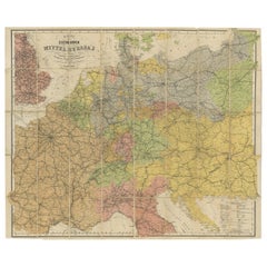
Antique Map of Germany and Central Europe – “Allemagne et Europe Centrale” by Andriveau-Goujon, 1865
This large, finely engraved map titled “Allemagne et Europe Centrale” was published in Paris in 1865 by E. Andriveau-Goujon, one of the most prominent 19th-century French map publishers. Issued as plate number 28 in the Atlas Universel, the map provides a highly detailed depiction of Central Europe on the eve of German unification, encompassing the German Confederation, the Austrian Empire, and neighboring states in their mid-19th-century political configuration.
The map covers a vast area from the Netherlands and eastern France in the west to Poland and western Russia in the east, and from the North Sea and Baltic Sea down to northern Italy, Hungary, and the Balkans. It captures the fragmented nature of the German states at the time, with Prussia, Bavaria, Saxony, Württemberg, Hanover, and numerous smaller duchies, bishoprics, and free cities all rendered in distinct pastel colors.
To the southeast, the map illustrates the full extent of the Austrian Empire in yellow, including modern-day Austria, Hungary, the Czech Republic, Slovakia, and parts of the Balkans. Important cities such as Berlin, Vienna, Munich, Frankfurt, Prague, Dresden, and Budapest are all clearly marked, along with roads, rivers, and administrative boundaries.
In the upper right corner, a legend titled “Abbreviations” lists the German Confederation’s member states and principal regions, such as the Kingdom of Prussia, Grand Duchy of Baden, and Duchy of Brunswick. At the bottom right, a key to symbols defines capital cities, fortified towns, and religious centers.
This map is a valuable historical record of Central Europe before the political reconfigurations brought about by the Austro-Prussian War of 1866 and the creation of the German Empire in 1871. It appeals to collectors interested in European history, German unification, and 19th-century political geography.
Condition: Very good. Light toning and minor foxing in the margins, original centerfold as issued. Clean engraving with delicate original hand coloring. Plate number 28 in upper right.
Framing tips: A dark wood or antique gold frame with a cream mat will highlight the detailed engraving and period colors. A muted green or burgundy inner mat could enhance the central European palette.
Technique: Engraving with original hand coloring
Maker: E. Andriveau-Goujon, Paris, 1865
- Dimensions:Height: 20.91 in (53.1 cm)Width: 27.64 in (70.2 cm)Depth: 0.01 in (0.2 mm)
- Materials and Techniques:Paper,Engraved
- Place of Origin:
- Period:
- Date of Manufacture:1865
- Condition:Condition: Very good. Light toning and minor foxing in the margins, original centerfold as issued. Clean engraving with delicate original hand coloring. Plate number 28 in upper right.
- Seller Location:Langweer, NL
- Reference Number:Seller: BG-14099-81stDibs: LU3054346185422
About the Seller
5.0
Recognized Seller
These prestigious sellers are industry leaders and represent the highest echelon for item quality and design.
Platinum Seller
Premium sellers with a 4.7+ rating and 24-hour response times
Established in 2009
1stDibs seller since 2017
2,567 sales on 1stDibs
Typical response time: <1 hour
- ShippingRetrieving quote...Shipping from: Langweer, Netherlands
- Return Policy
Authenticity Guarantee
In the unlikely event there’s an issue with an item’s authenticity, contact us within 1 year for a full refund. DetailsMoney-Back Guarantee
If your item is not as described, is damaged in transit, or does not arrive, contact us within 7 days for a full refund. Details24-Hour Cancellation
You have a 24-hour grace period in which to reconsider your purchase, with no questions asked.Vetted Professional Sellers
Our world-class sellers must adhere to strict standards for service and quality, maintaining the integrity of our listings.Price-Match Guarantee
If you find that a seller listed the same item for a lower price elsewhere, we’ll match it.Trusted Global Delivery
Our best-in-class carrier network provides specialized shipping options worldwide, including custom delivery.More From This Seller
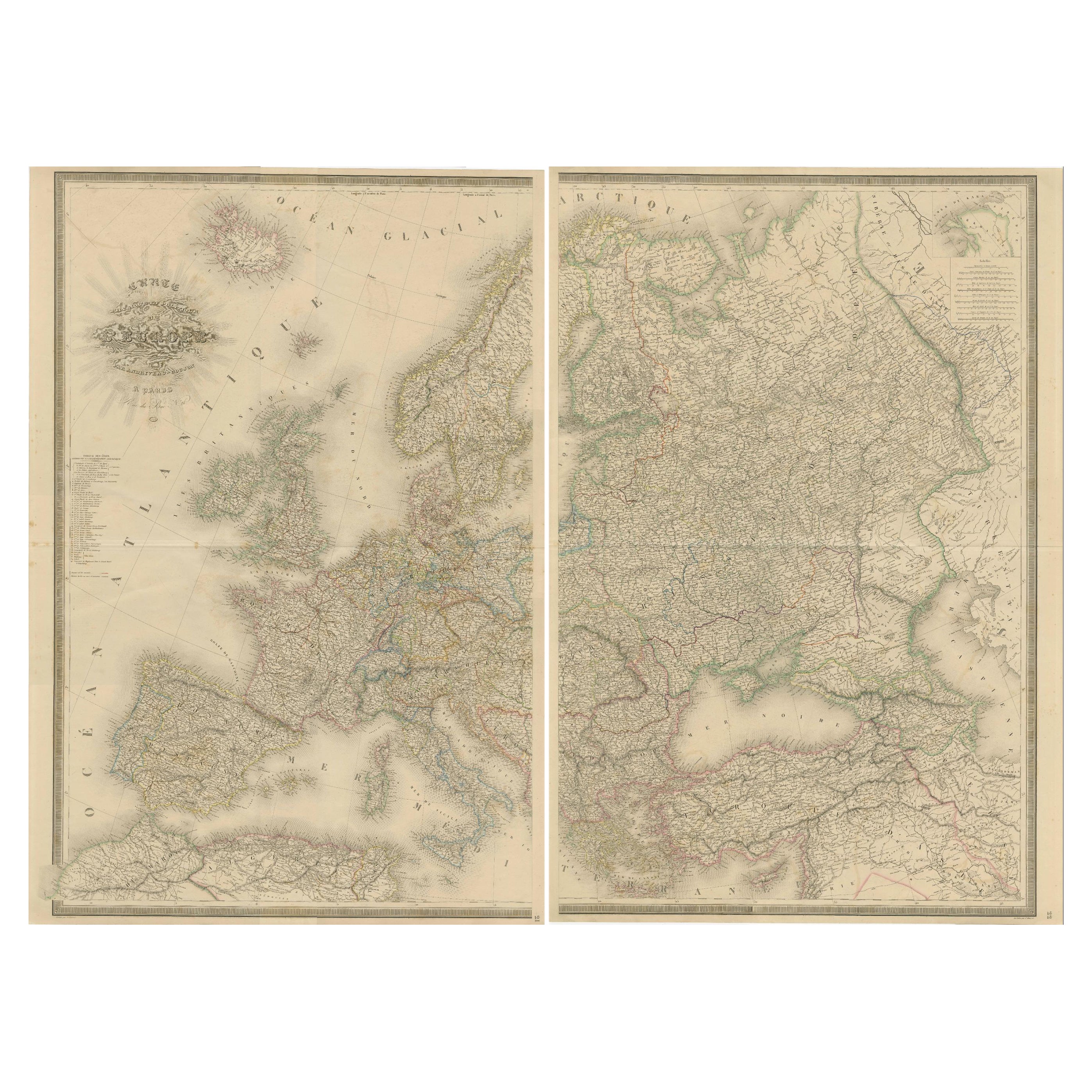
View AllMajestic Map of Europe by Andriveau-Goujon - Complete Continental View - ca.1849
Located in Langweer, NL
Majestic 19th Century Map of Europe by Andriveau-Goujon - Complete Continental View - Circa 1849
This magnificent and intricately detailed map of Europe, titled "Carte Physique et...
Category
Antique 1840s Maps
Materials
Paper
$732 Sale Price / set
20% Off
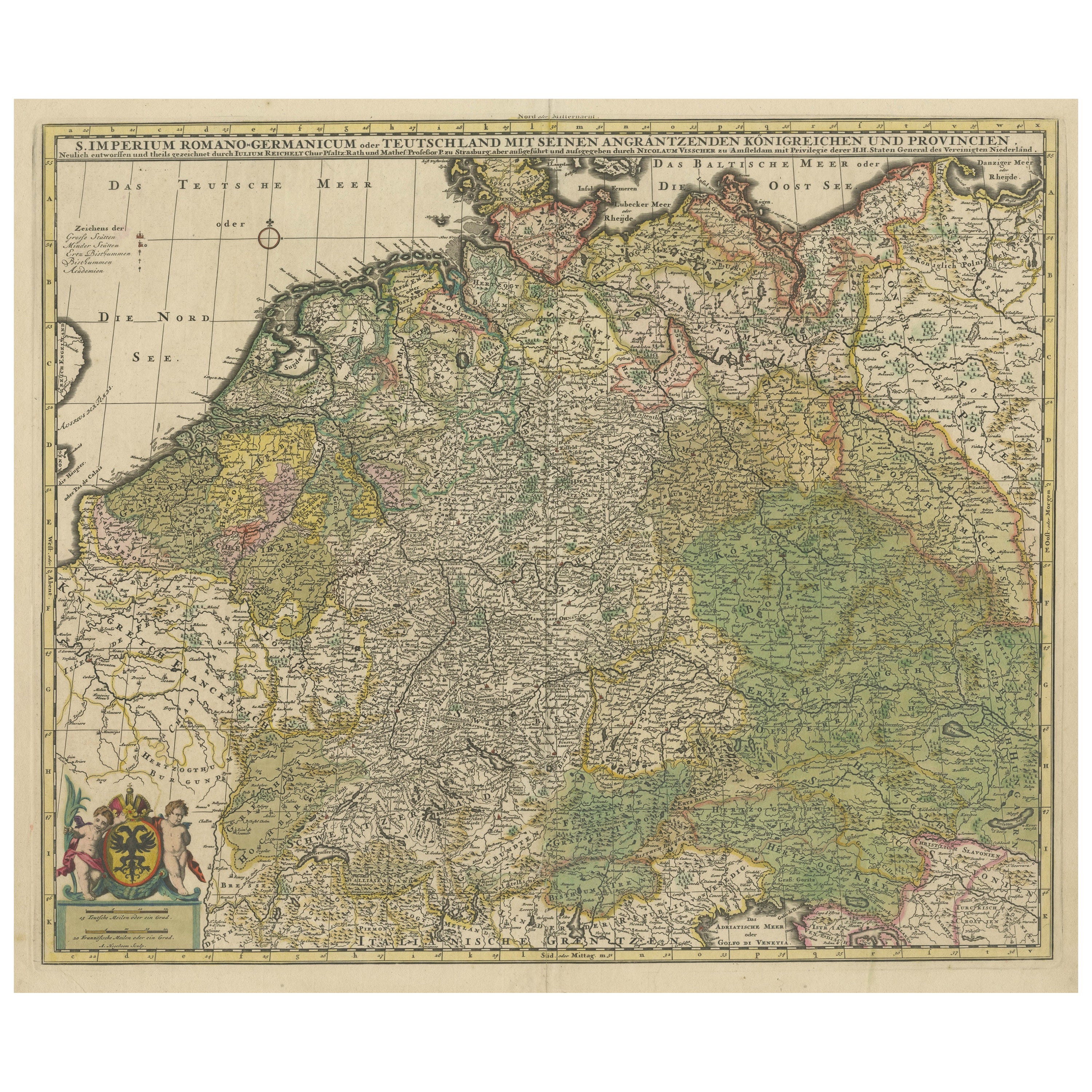
Antique Map of Germany and Central Europe
Located in Langweer, NL
Antique map titled 'S. Imperium Romano-Germanicum oder Teutschland mit seinen angrantzenden Königreichen und Provincien'. Original antique map of Germany...
Category
Antique Late 17th Century Maps
Materials
Paper

$1,045 Sale Price
20% Off
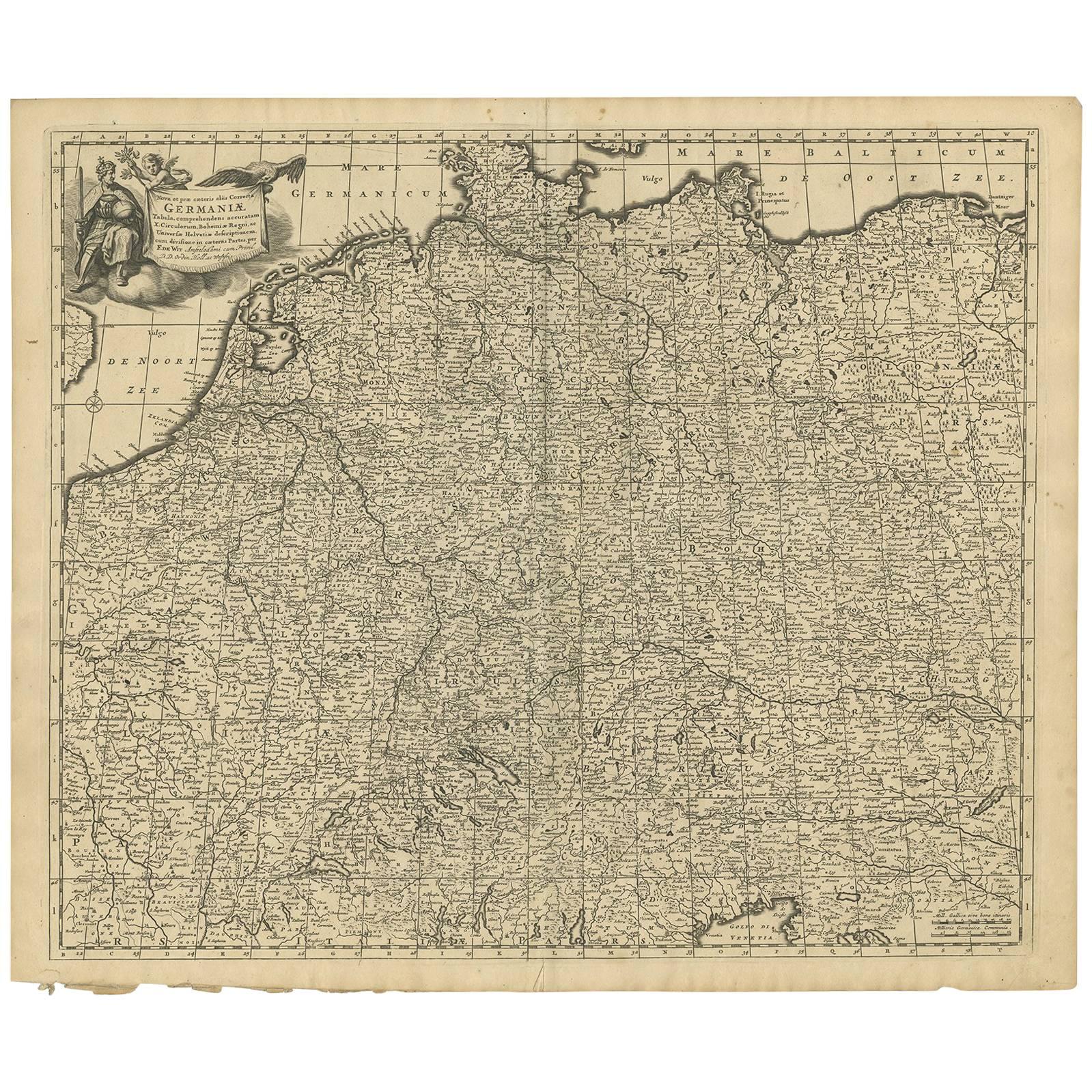
Antique Map of Central Europe "Centered on Germany" by F. de Wit, circa 1680
Located in Langweer, NL
A very detailed map of central Europe, centered on Germany. It extends from Belgium and The Netherlands through Pomerania in the north, and from eastern France to Croatia in the sout...
Category
Antique Late 17th Century Maps
Materials
Paper
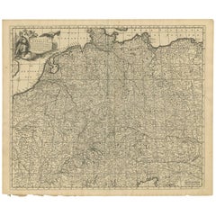
$807 Sale Price
20% Off
Antique Map of South-Western Germany by A.K. Johnston, 1865
Located in Langweer, NL
Antique map titled 'South-Western Germany'. This map originates from the ‘Royal Atlas of Modern Geography’ by Alexander Keith Johnston. Published by William Blackwood and Sons, Edinb...
Category
Antique Mid-19th Century Maps
Materials
Paper
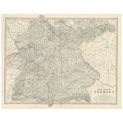
$237 Sale Price
20% Off
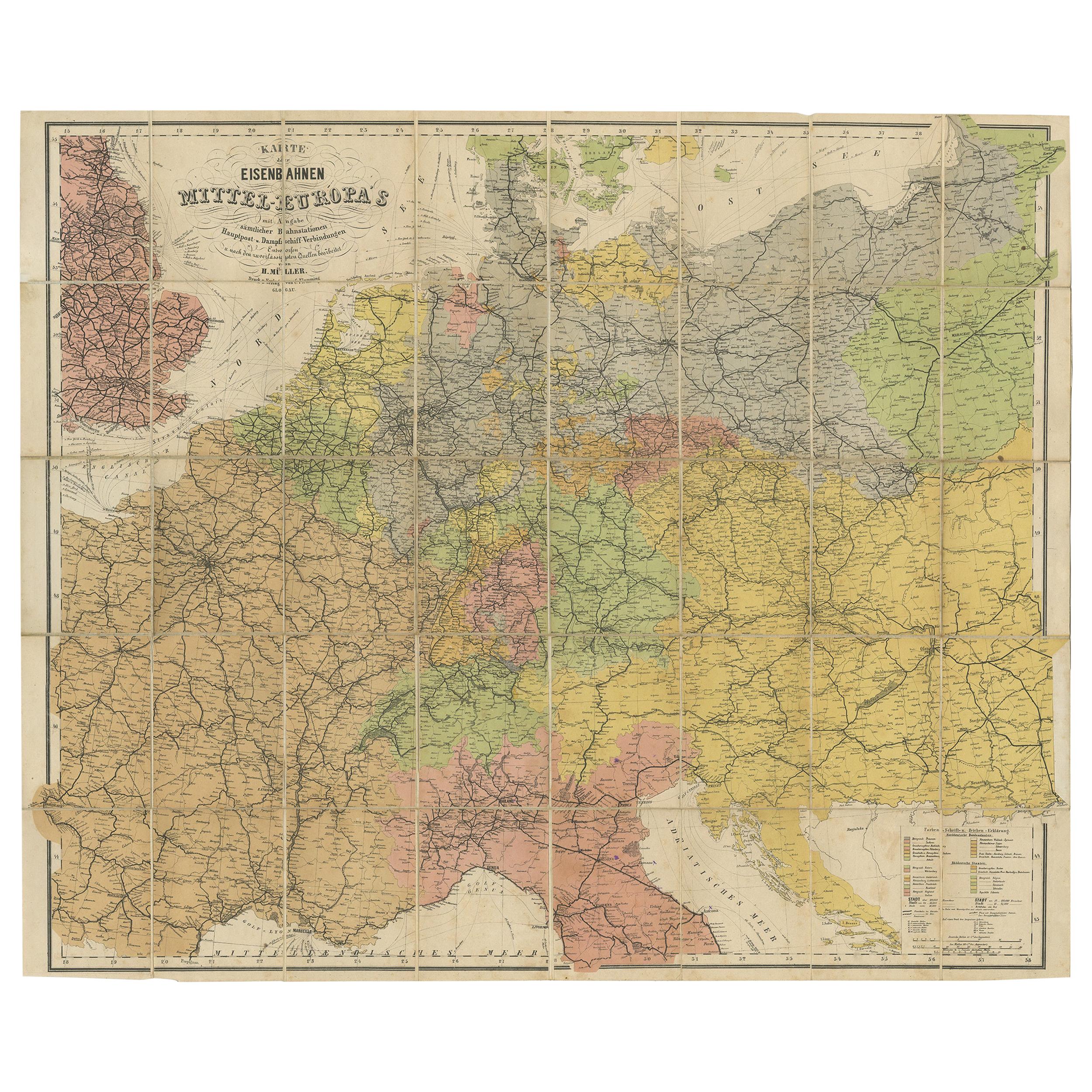
Antique Railway Folding Map of Central Europe by Müller, 1870
Located in Langweer, NL
Antique map titled 'Karte der Eisenbahnen Mittel-Europa's (..)'. Railway folding map of Central Europe. Published by Carl Flemming, 1870.
Category
Antique Late 19th Century Maps
Materials
Paper
$712 Sale Price
20% Off
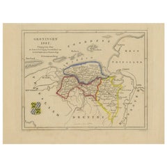
Antique Map of Groningen by Veelwaard, c.1865
Located in Langweer, NL
Antique map titled 'Groningen 1861'. Map of Groningen, the Netherlands. Published by 'Gewest. Vereeniging Noord Holland van het Ned. Onderwijzers-Genootschap'. Artists and Engravers:...
Category
Antique 19th Century Maps
Materials
Paper
$90 Sale Price
20% Off
You May Also Like
Antique Map of Italy by Andriveau-Goujon, 1843
By Andriveau-Goujon
Located in New York, NY
Antique Map of Italy by Andriveau-Goujon, 1843. Map of Italy in two parts by Andriveau-Goujon for the Library of Prince Carini at Palazzo Carini i...
Category
Antique 1840s French Maps
Materials
Linen, Paper

$3,350 / set
Plan of Paris, France, by A. Vuillemin, Antique Map, 1845
Located in Colorado Springs, CO
This large and detailed plan of Paris was published by Alexandre Vuillemin in 1845. The map conveys a wonderful amount of information and is decorated throughout with pictorial vigne...
Category
Antique 1840s American Maps
Materials
Paper

Original Antique Map of Europe, Arrowsmith, 1820
Located in St Annes, Lancashire
Great map of Europe
Drawn under the direction of Arrowsmith.
Copper-plate engraving.
Published by Longman, Hurst, Rees, Orme and Brown, 1820
...
Category
Antique 1820s English Maps
Materials
Paper

Original Antique Map of Central America / Florida, Arrowsmith, 1820
Located in St Annes, Lancashire
Great map of Central America.
Drawn under the direction of Arrowsmith.
Copper-plate engraving.
Published by Longman, Hurst, Rees, Orme and Brown, 1820
Unframed.
Category
Antique 1820s English Maps
Materials
Paper

Large Original Antique Map of Europe by Sidney Hall, 1847
Located in St Annes, Lancashire
Great map of Europe
Drawn and engraved by Sidney Hall
Steel engraving
Original colour outline
Published by A & C Black. 1847
Unframed
Free shipping.
Category
Antique 1840s Scottish Maps
Materials
Paper

Vintage Central European Wooden Element
Located in High Point, NC
A wooden decoration created in 20th century central Europe. Crafted in an inherently minimal design, this unique element doesn’t fail to please the eye all the way around its structu...
Category
20th Century European Industrial Historical Memorabilia
Materials
Wood