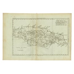
Highly Detailed Antique Map of Jamaica in the Caribbean, c.1780
View Similar Items


Want more images or videos?
Request additional images or videos from the seller
1 of 5
Highly Detailed Antique Map of Jamaica in the Caribbean, c.1780
Price:$166.84
$208.55List Price
About the Item
- Dimensions:Height: 14.97 in (38 cm)Width: 10.24 in (26 cm)Depth: 0 in (0.01 mm)
- Materials and Techniques:
- Period:
- Date of Manufacture:circa 1780
- Condition:Condition: Good, given age. Slight discolouration middle fold. Vertical crease left of middle fold. Original middle fold as issued. General age-related toning and/or occasional minor defects from handling. Please study image carefully.
- Seller Location:Langweer, NL
- Reference Number:Seller: PCT-615731stDibs: LU3054326361112
About the Seller
5.0
Recognized Seller
These prestigious sellers are industry leaders and represent the highest echelon for item quality and design.
Platinum Seller
Premium sellers with a 4.7+ rating and 24-hour response times
Established in 2009
1stDibs seller since 2017
2,569 sales on 1stDibs
Authenticity Guarantee
In the unlikely event there’s an issue with an item’s authenticity, contact us within 1 year for a full refund. DetailsMoney-Back Guarantee
If your item is not as described, is damaged in transit, or does not arrive, contact us within 7 days for a full refund. Details24-Hour Cancellation
You have a 24-hour grace period in which to reconsider your purchase, with no questions asked.Vetted Professional Sellers
Our world-class sellers must adhere to strict standards for service and quality, maintaining the integrity of our listings.Price-Match Guarantee
If you find that a seller listed the same item for a lower price elsewhere, we’ll match it.Trusted Global Delivery
Our best-in-class carrier network provides specialized shipping options worldwide, including custom delivery.More From This Seller
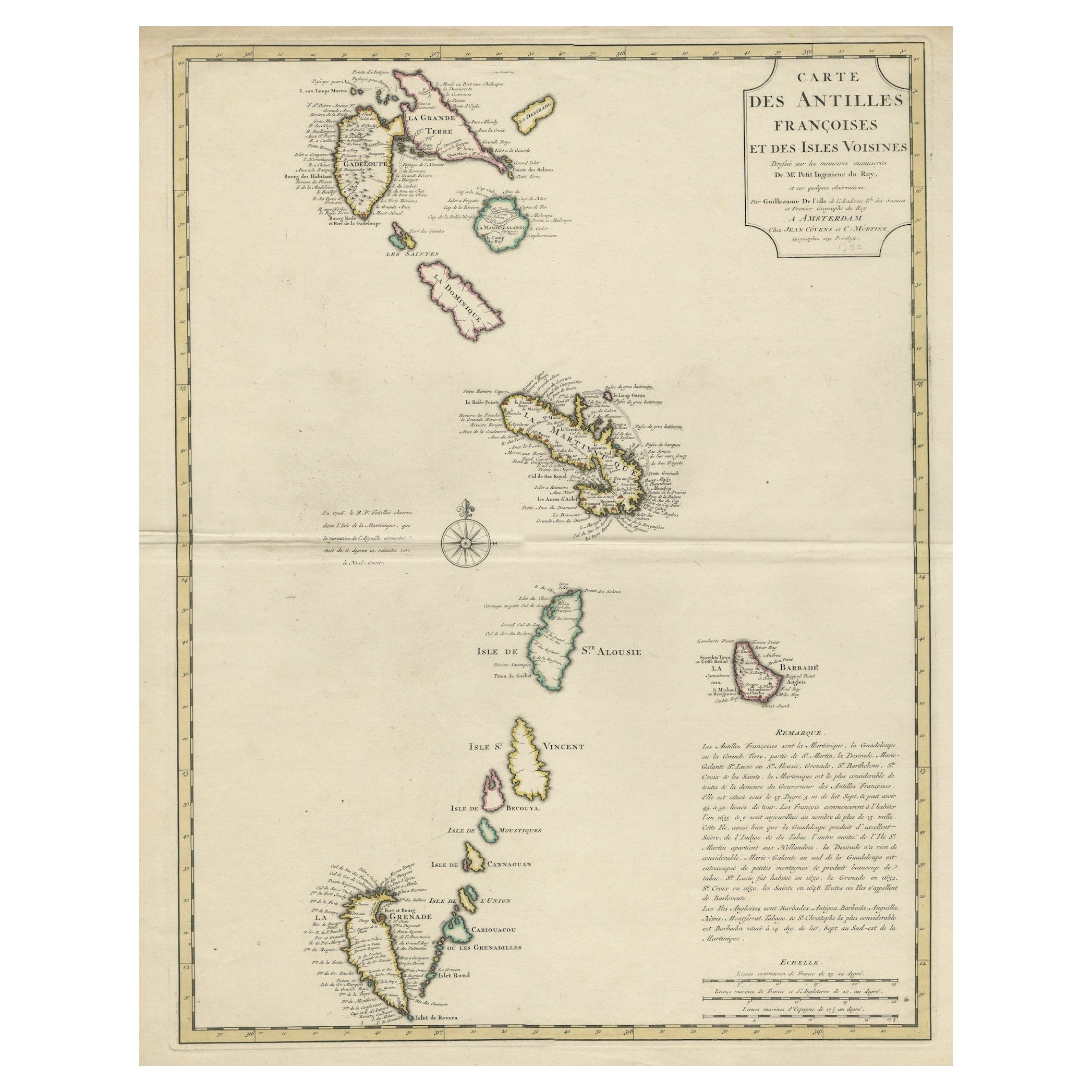
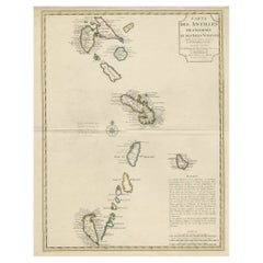
View AllDetailed Antique Map of the Windward Islands in the Caribbean
By Covens & Mortier
Located in Langweer, NL
Antique map titled 'Carte des Antilles Francoises et des Isles Voisines'. Original antique map of the French Antilles, covering an area stretching from Guadeloupe in the north to Gre...
Category
Antique Early 18th Century Maps
Materials
Paper
$896 Sale Price
20% Off
Antique Map of the Antilles in the Caribbean, '1875'
Located in Langweer, NL
Antique map titled 'Carte des Iles Antilles'. Large map of the Antilles. This map originates from 'Atlas de Géographie Moderne Physique et Politique' by A. Levasseur. Published, 1875.
Category
Antique Late 19th Century Maps
Materials
Paper

$357 Sale Price
40% Off
Highly Detailed Antique Map of the Holy Land Showing 12 Tribes of Israel, c.1720
Located in Langweer, NL
Antique map titled 'Heylige Land verdeeld in de Twaalf Stammen Israels (..).'
Highly detailed map of the Holy Land divided into 12 tribes of Israel...
Category
Antique 1720s Maps
Materials
Paper

$457 Sale Price
20% Off
Free Shipping
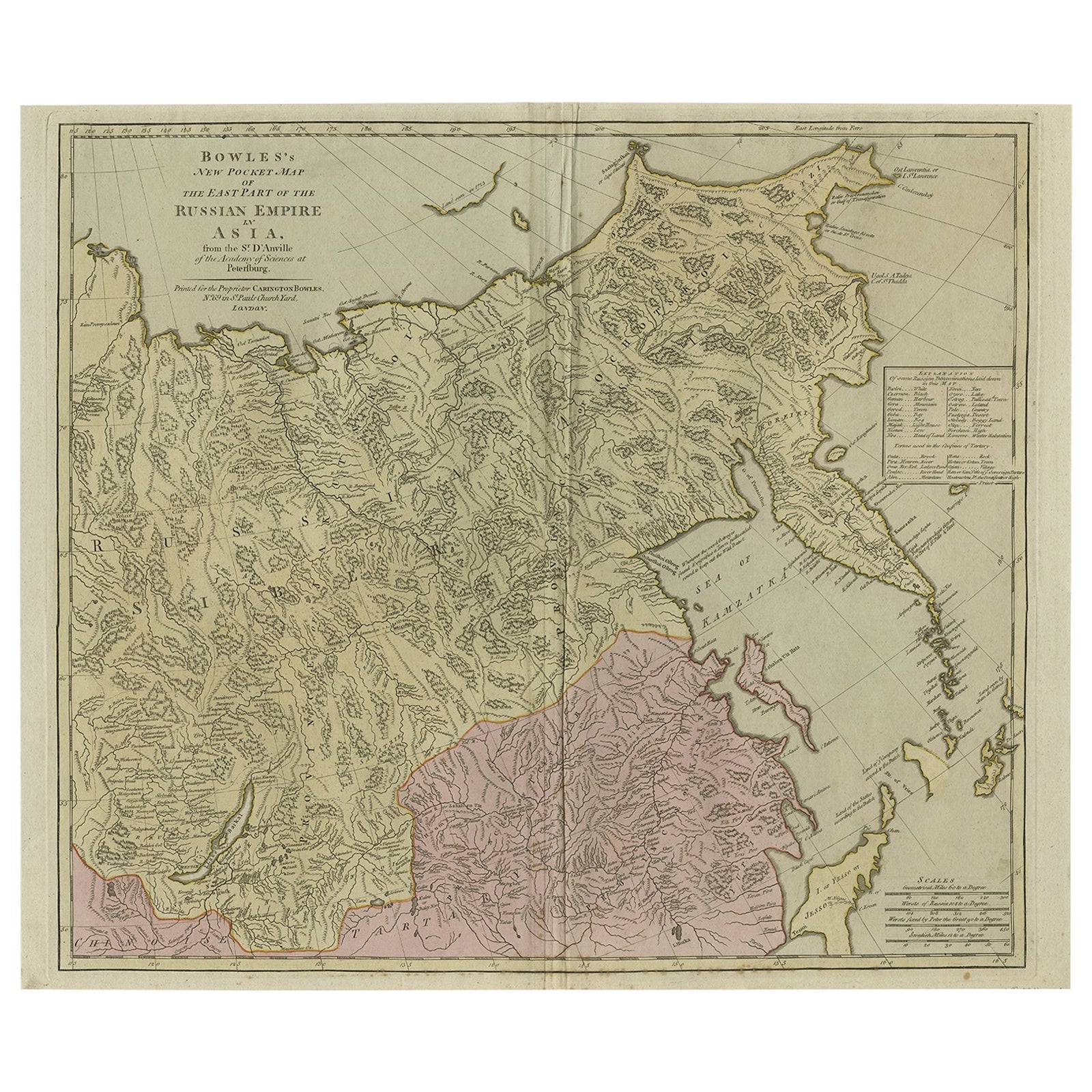
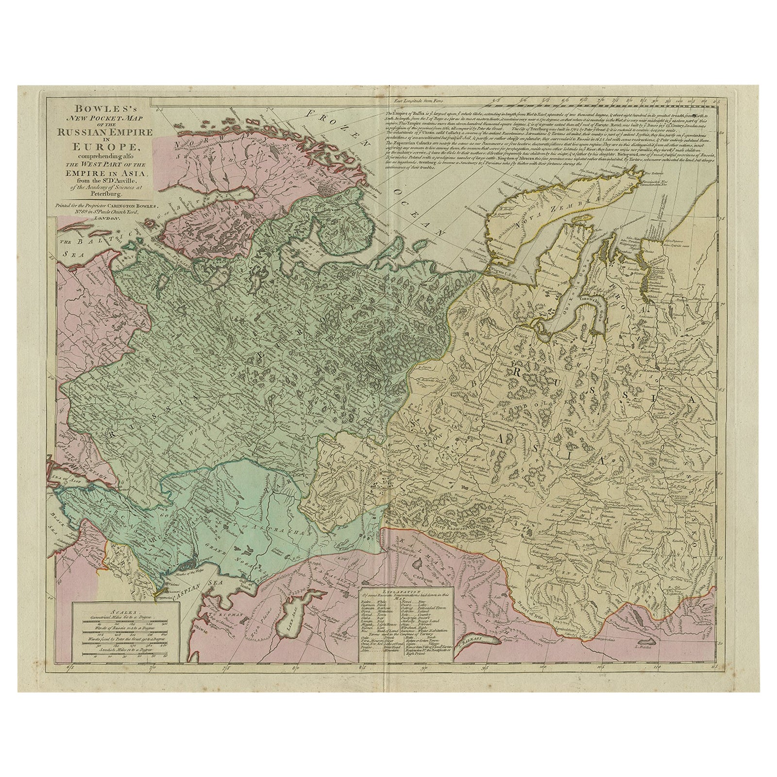
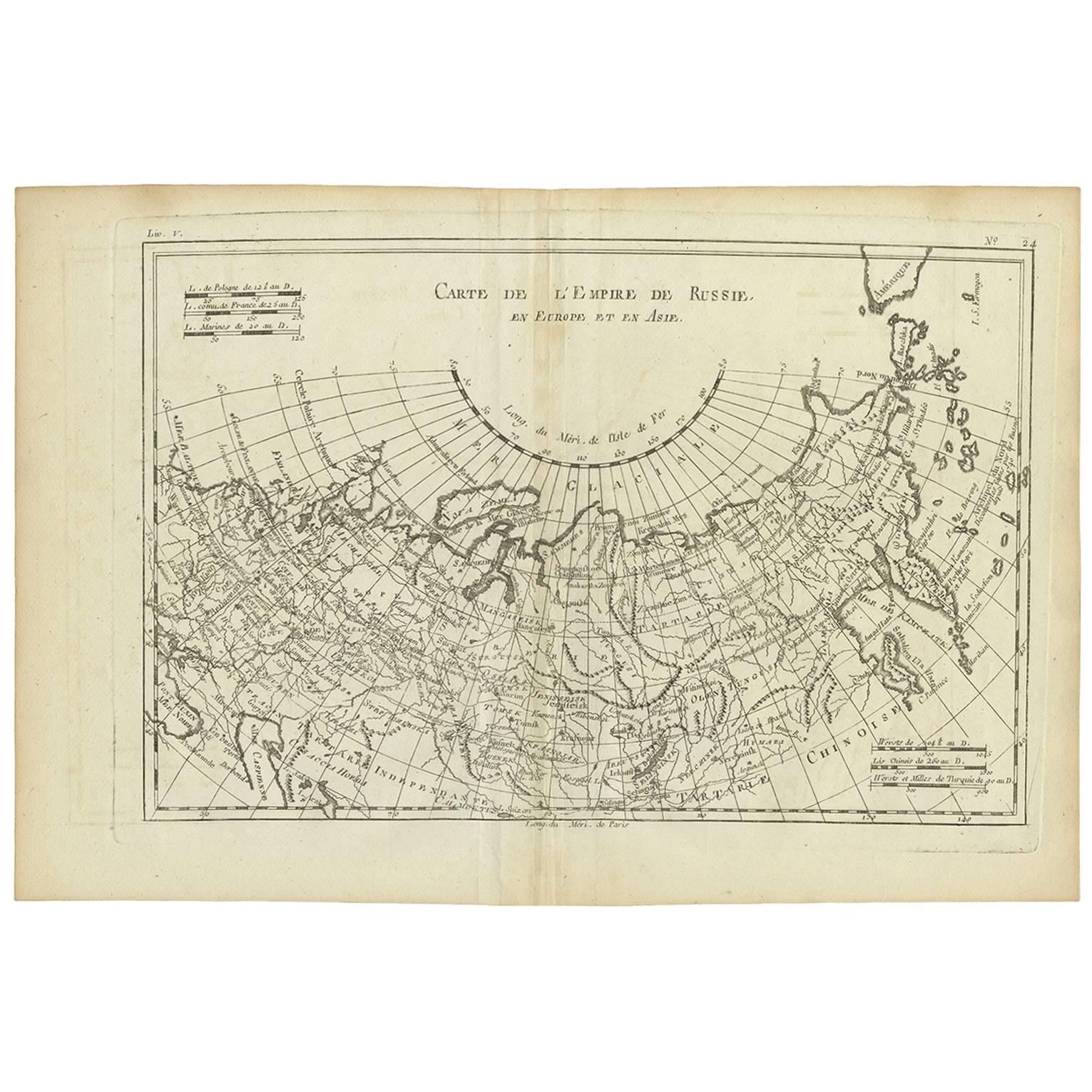
Large and Detailed Map of the Russian Empire in Asia, ca.1780
Located in Langweer, NL
Description: Antique map titled 'Bowles's New Pocket Map of the East Part of the Russian Empire in Asia'. Large and detailed map of the Russian Empire in Asia. Source unknown, to be determined.
Artists and Engravers: Made by 'Thomas & Carington Bowles' after 'D'Anville'. Thomas Bowles, born around 1712, was map publisher and seller in London...
Category
Antique 1780s Maps
Materials
Paper
$810 Sale Price
20% Off
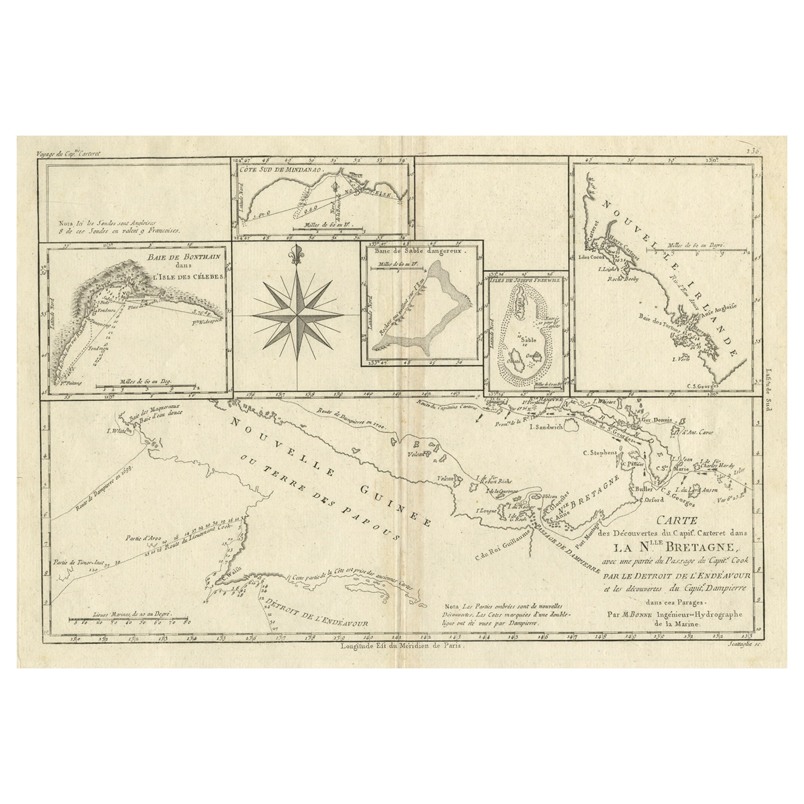
Antique Detailed Map of Papua New Guinea and the Regions to the West, ca.1780
Located in Langweer, NL
Antique map titled 'Carte des Decouvertes du Capite. Carteret dans La Nlle. Bretagne avec une parte du passage du Capite. Cook Par Le Detroit De L'Endeavor ...
Category
Antique 1780s Maps
Materials
Paper
$314 Sale Price
20% Off
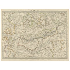
Detailed Antique Map of the Region of Malwa in India, 1833
Located in Langweer, NL
Antique map titled 'India VI'. Old steel engraved map of the region of Malwa showing great detail.
Artists and Engravers: Engraved by J. & C. Walker. Published under the superint...
Category
Antique 19th Century Maps
Materials
Paper
$276 Sale Price
20% Off
You May Also Like
Original Antique Map of South America. C.1780
Located in St Annes, Lancashire
Great map of South America
Copper-plate engraving
Published C.1780
Two small worm holes to left side of map
Unframed.
Category
Antique Early 1800s English Georgian Maps
Materials
Paper

Map of the Republic of Genoa
Located in New York, NY
Framed antique hand-coloured map of the Republic of Genoa including the duchies of Mantua, Modena, and Parma.
Europe, late 18th century.
Dimension: 25...
Category
Antique Late 18th Century European Maps

Antique Map of Principality of Monaco
By Antonio Vallardi Editore
Located in Alessandria, Piemonte
ST/619 - "Old Geographical Atlas of Italy - Topographic map of ex-Principality of Monaco" -
ediz Vallardi - Milano -
A somewhat special edition ---
Category
Antique Late 19th Century Italian Other Prints
Materials
Paper

Antique 18th Century Map of the Province of Pensilvania 'Pennsylvania State'
Located in Philadelphia, PA
A fine antique of the colony of Pennsylvania.
Noted at the top of the sheet as a 'Map of the province of Pensilvania'.
This undated and anonymous map is thought to be from the Gentleman's Magazine, London, circa 1775, although the general appearance could date it to the 1760's.
The southern boundary reflects the Mason-Dixon survey (1768), the western boundary is placed just west of Pittsburgh, and the northern boundary is not marked.
The map has a number of reference points that likely refer to companion text and appear to be connected to boundaries. The western and southern boundaries are marked Q, R, S, for example. A diagonal line runs from the Susquehanna R to the Lake Erie P. A broken line marked by many letters A, B, N, O, etc., appears in the east.
There are no latitude or longitude markings, blank verso.
Framed in a shaped contemporary gilt wooden frame and matted under a cream colored matte.
Bearing an old Graham Arader Gallery...
Category
Antique 18th Century British American Colonial Maps
Materials
Paper

Original Antique Map of The World by Thomas Clerk, 1817
Located in St Annes, Lancashire
Great map of The Eastern and Western Hemispheres
On 2 sheets
Copper-plate engraving
Drawn and engraved by Thomas Clerk, Edinburgh.
Published by Mackenzie And Dent, 1817
...
Category
Antique 1810s English Maps
Materials
Paper

Map "Estuary- Mouth of the Thames"
Located in Alessandria, Piemonte
ST/426 - Antique French Map of the estuary of the Thames, map dated 1769 -
"Mape of the entrance of the Thames. Designed by filing of Navy cards fo...
Category
Antique Mid-18th Century French Other Prints
Materials
Paper
