Items Similar to Historic Map of the Bishopric of Paderborn by Blaeu, a Masterpiece of 1645


Want more images or videos?
Request additional images or videos from the seller
1 of 7
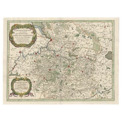
Historic Map of the Bishopric of Paderborn by Blaeu, a Masterpiece of 1645
$498.43
$623.0320% Off
£370.98
£463.7220% Off
€416
€52020% Off
CA$682.72
CA$853.4020% Off
A$759.34
A$949.1720% Off
CHF 396.50
CHF 495.6320% Off
MX$9,240.30
MX$11,550.3820% Off
NOK 5,063.93
NOK 6,329.9120% Off
SEK 4,749.07
SEK 5,936.3420% Off
DKK 3,166.86
DKK 3,958.5820% Off
Shipping
Retrieving quote...The 1stDibs Promise:
Authenticity Guarantee,
Money-Back Guarantee,
24-Hour Cancellation
About the Item
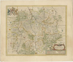
This hand-colored map, titled "Paderbornensis Episcopatus Descriptio Nova," depicts the Bishopric of Paderborn, a historical ecclesiastical territory within the Holy Roman Empire, located in present-day North Rhine-Westphalia, Germany.
Created by Johannes Gigante Ludolphus, the map was engraved and published by Willem and Joan Blaeu in Amsterdam as part of their renowned *Theatrum Orbis Terrarum, sive Atlas Novus* in the mid-17th century.
The map is richly detailed, showing the towns, rivers, forests, and mountains of the region, with an emphasis on its ecclesiastical and political divisions. Heraldic crests and coats of arms are prominently displayed, representing the bishopric's administrative authority. The title cartouche and decorative elements highlight the artistry typical of Blaeu maps, blending cartographic accuracy with visual elegance.
- Cartographer: Johannes Gigante Ludolphus
- Engraver/Publisher: Willem Blaeu and Joan Blaeu
- Title: Paderbornensis Episcopatus Descriptio Nova
- Publication: Amsterdam, Blaeu Publishing, circa 1645
- Description: A detailed and visually stunning map of the Bishopric of Paderborn, located in modern-day Germany. The map displays settlements, rivers, forests, and heraldic symbols. Beautifully hand-colored, it features an elaborate title cartouche and precise engraving, representative of the Blaeu family's celebrated style.
- Condition: Old hand-coloring in vibrant tones. Margins show minor toning, with some light spotting. Edges are slightly worn but intact. The map itself is clean, with sharp details and no significant tears or damage. Overall, an excellent example of a 17th-century map.
- Significance: From Blaeu’s *Atlas Novus*, this map exemplifies the merging of scientific accuracy and artistic beauty, making it a valuable piece for collectors and historians of European cartography.
- Dimensions:Height: 17.92 in (45.5 cm)Width: 22.64 in (57.5 cm)Depth: 0.01 in (0.2 mm)
- Materials and Techniques:Paper,Engraved
- Period:1640-1649
- Date of Manufacture:1645
- Condition:Good condition: Old hand-coloring in vibrant tones. Margins show minor toning, with some light spotting. Edges are slightly worn but intact. The map itself is clean, with sharp details and no significant tears or damage.
- Seller Location:Langweer, NL
- Reference Number:Seller: BG-13892-31stDibs: LU3054342438612
About the Seller
5.0
Recognized Seller
These prestigious sellers are industry leaders and represent the highest echelon for item quality and design.
Platinum Seller
Premium sellers with a 4.7+ rating and 24-hour response times
Established in 2009
1stDibs seller since 2017
2,502 sales on 1stDibs
Typical response time: <1 hour
- ShippingRetrieving quote...Shipping from: Langweer, Netherlands
- Return Policy
Authenticity Guarantee
In the unlikely event there’s an issue with an item’s authenticity, contact us within 1 year for a full refund. DetailsMoney-Back Guarantee
If your item is not as described, is damaged in transit, or does not arrive, contact us within 7 days for a full refund. Details24-Hour Cancellation
You have a 24-hour grace period in which to reconsider your purchase, with no questions asked.Vetted Professional Sellers
Our world-class sellers must adhere to strict standards for service and quality, maintaining the integrity of our listings.Price-Match Guarantee
If you find that a seller listed the same item for a lower price elsewhere, we’ll match it.Trusted Global Delivery
Our best-in-class carrier network provides specialized shipping options worldwide, including custom delivery.More From This Seller
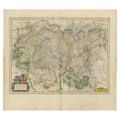
View AllBishopric of Hildesheim Map in Northern Germany by Willem & Joan Blaeu, 1645
Located in Langweer, NL
This beautifully hand-colored map, titled "Episcopatus Hildesiensis Descriptio Novissima," depicts the Bishopric of Hildesheim, a historical ecclesiastical territory in present-day L...
Category
Antique 1640s Maps
Materials
Paper
$498 Sale Price
20% Off
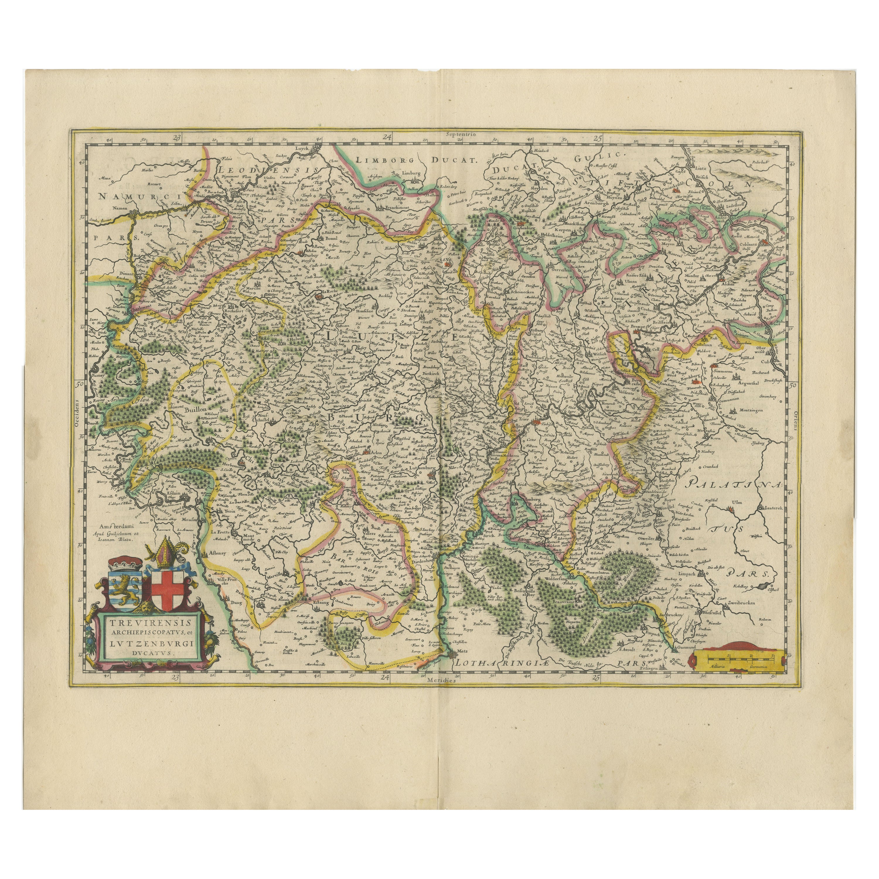
Original Antique Map of Trier and Luxembourg by Joan Blaeu, Amsterdam circa 1640
Located in Langweer, NL
Map of Trier and Luxembourg by Joan Blaeu, Amsterdam circa 1640
This beautifully engraved and hand-colored map titled Trevirensis Archiepiscopatus, et Lutzenburgi Ducatus depicts th...
Category
Antique Mid-17th Century Dutch Maps
Materials
Paper
Antique Map of the County of Bentheim by Hondius, c.1630
Located in Langweer, NL
Antique map titled 'Comitatus Bentheimensis nova descriptio'. Engraved map of the County of Bentheim, showing Linge, Enschede, Bad Bentheim, Coevorden, Ne...
Category
Antique 17th Century Maps
Materials
Paper
$392 Sale Price
20% Off
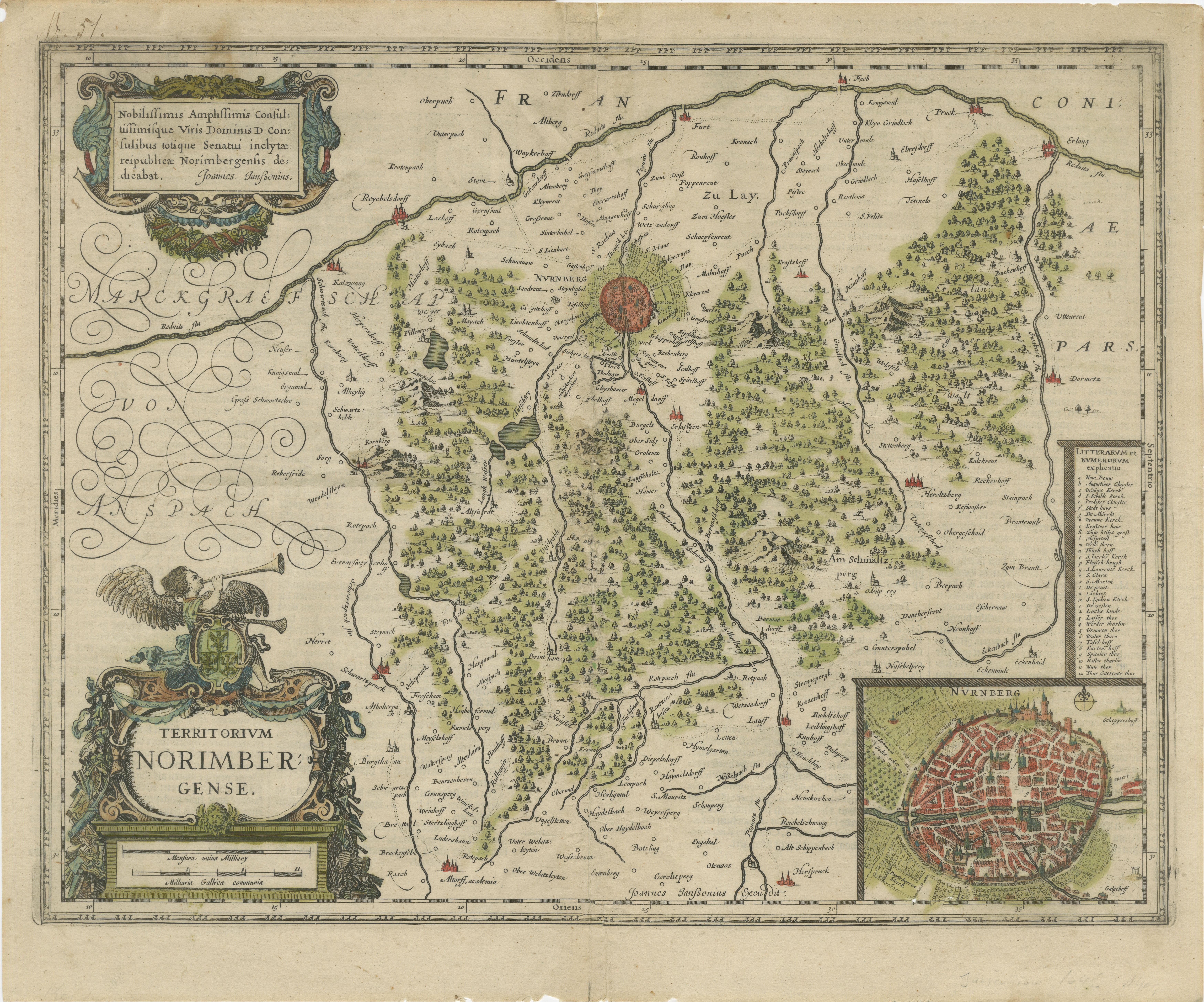
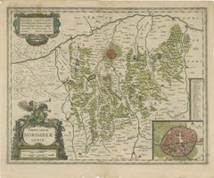
Territorium Norimbergense - Antique Map of Nürnberg by Janssonius (1645-58)
Located in Langweer, NL
This is an antique map of Nürnberg, titled "Territorium Norimbergense," created by Johannes Janssonius and published between 1645 and 1658. It is a copperplate engraving printed on p...
Category
Antique 1650s Maps
Materials
Paper
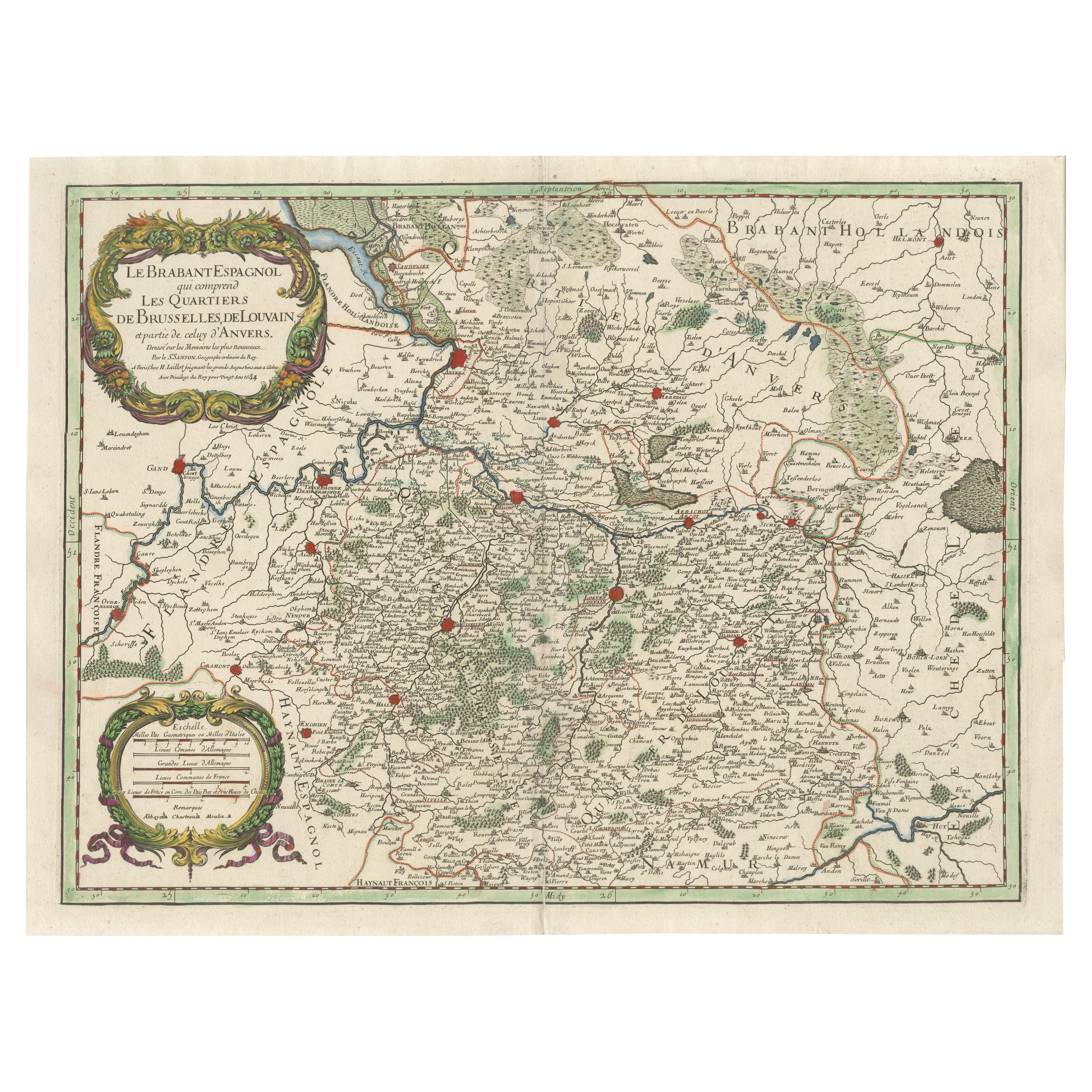
Original Spanish Brabant map with Brussels, Louvain and Antwerp quarters, c.1684
Located in Langweer, NL
Spanish Brabant map with Brussels, Louvain, and Antwerp quarters, c.1690
Description:
This richly detailed antique map depicts the historical region of Spanish Brabant, focusing on ...
Category
Antique Late 17th Century French Maps
Materials
Paper
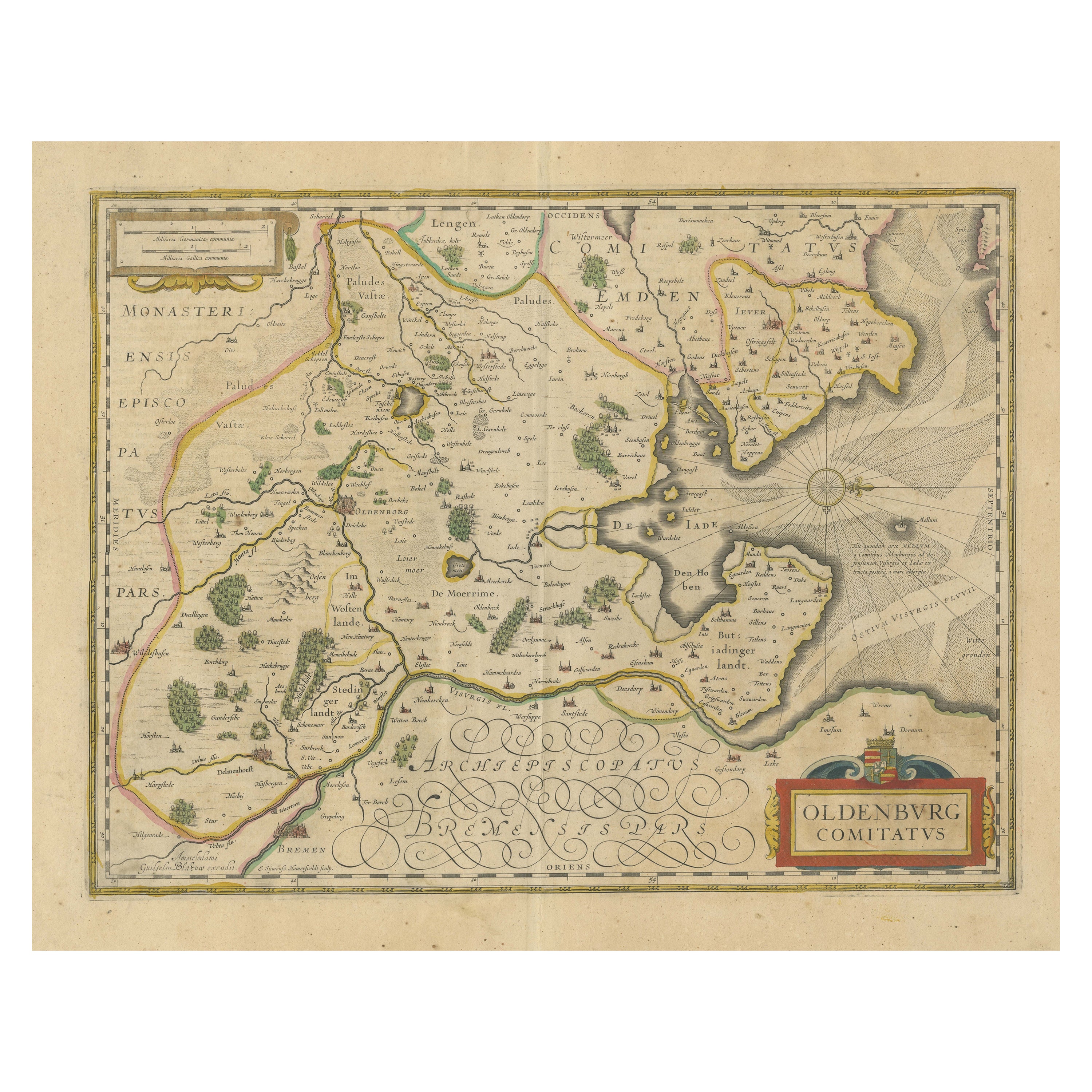
Antique Map of the Region of Oldenburg, Germany
By Willem Blaeu
Located in Langweer, NL
Antique map titled 'Oldenburg Comitatus'. Detailed old map of Oldenburg, Germany. The map also shows Bremen and the Jade Bight. Published by W. Blaeu, circa 1640. Willem Jansz. Blaeu...
Category
Antique Mid-17th Century Maps
Materials
Paper
$421 Sale Price
20% Off
You May Also Like
Cambridgeshire map 17th century engraving by John Speed
By John Speed
Located in London, GB
To see more, scroll down to "More from this Seller" and below it click on "See all from this Seller."
John Speed (1551 or 1552 - 1629)
Map of Cambridgeshire
Engraving with later hand colouring
39 x 53 cm
A beautifully coloured map of Cambridgeshire, with an antique description...
Category
1610s Landscape Prints
Materials
Engraving

17th Century Hand-Colored Map of a Region in West Germany by Janssonius
By Johannes Janssonius
Located in Alamo, CA
This attractive highly detailed 17th century original hand-colored map is entitled "Archiepiscopatus Maghdeburgensis et Anhaltinus Ducatus cum terris adjacentibus". It was published ...
Category
Antique Mid-17th Century Dutch Maps
Materials
Paper

Prussia, Poland, N. Germany, Etc: A Hand-colored 17th Century Map by Janssonius
By Johannes Janssonius
Located in Alamo, CA
This is an attractive hand-colored copperplate engraved 17th century map of Prussia entitled "Prussia Accurate Descripta a Gasparo Henneberg Erlichensi", published in Amsterdam by Joannes Janssonius in 1664. This very detailed map from the golden age of Dutch cartography includes present-day Poland, Latvia, Lithuania, Estonia and portions of Germany. This highly detailed map is embellished by three ornate pink, red, mint green and gold...
Category
Antique Mid-17th Century Dutch Maps
Materials
Paper

West Germany: Original Hand Colored 17th Century Map by Johannes Janssonius
By Johannes Janssonius
Located in Alamo, CA
An original hand colored copperplate engraved map entitled in Latin "Archiepiscopatus Maghdeburgensis et Anhaltinus Ducatus cum terris adjacentibus", published in Amsterdam in 1640 i...
Category
Mid-17th Century Old Masters More Prints
Materials
Engraving

17th Century Hand Colored Map of the Liege Region in Belgium by Visscher
By Nicolaes Visscher II
Located in Alamo, CA
An original 17th century map entitled "Leodiensis Episcopatus in omnes Subjacentes Provincias distincté divisusVisscher, Leodiensis Episcopatus" by Nicolaes Visscher II, published in Amsterdam in 1688. The map is centered on Liege, Belgium, includes the area between Antwerp, Turnhout, Roermond, Cologne, Trier and Dinant.
This attractive map is presented in a cream-colored mat measuring 30" wide x 27.5" high. There is a central fold, as issued. There is minimal spotting in the upper margin and a tiny spot in the right lower margin, which are under the mat. The map is otherwise in excellent condition.
The Visscher family were one of the great cartographic families of the 17th century. Begun by Claes Jansz Visscher...
Category
Antique Late 17th Century Dutch Maps
Materials
Paper

1630 Pierre Petit map "Description du Gouvernement de la Capelle" Ric0010
Located in Norton, MA
1630 Pierre Petit map entitled
"Description du Gouvernement de la Capelle,"
Ric0010
Pierre Petit was the son of a minor provincial official in Montluçon. The town, in the Auver...
Category
Antique 17th Century Dutch Maps
Materials
Paper

More Ways To Browse
Coat Of Arms Engraving
Heraldic Crest
Elios Chair
Plata Lappas
Red Retro Dining Set
Antique Bouquet
Antique Silver Glasses Case
Carlo Scarpa 1934 Chairs
Christofle Marly
1900 Antique Chairs
Glass Table Italian Round
Mid Century Colonial
Alvar Aalto Poster
Geometric Metal Table
Post Modern High Chairs
United Nations
Vintage Vine Rug
Cancel An Order