Items Similar to Historical Map of Ancient Germany (1787): Tribes and Territories by Mentele


Want more images or videos?
Request additional images or videos from the seller
1 of 7
Historical Map of Ancient Germany (1787): Tribes and Territories by Mentele
$344.95
$431.1920% Off
£255.63
£319.5320% Off
€288
€36020% Off
CA$470.92
CA$588.6520% Off
A$523.88
A$654.8520% Off
CHF 274.62
CHF 343.2820% Off
MX$6,401.69
MX$8,002.1120% Off
NOK 3,497
NOK 4,371.2520% Off
SEK 3,291.94
SEK 4,114.9320% Off
DKK 2,192.81
DKK 2,741.0120% Off
Shipping
Retrieving quote...The 1stDibs Promise:
Authenticity Guarantee,
Money-Back Guarantee,
24-Hour Cancellation
About the Item
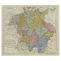
This antique map, titled "Carte Ancienne d'Allemagne," represents ancient Germany and surrounding regions. It was published by the well-known Parisian mapmakers and publishers Jean-Baptiste-Louis Clouet and Alexandre Aimé Vuillemin in the late 18th century, specifically in 1787.
The map covers the extensive geographical area of ancient Germany, highlighting various tribes and regions known at the time. Key features include:
1. **Geographical Boundaries**: The map outlines the territorial extents of ancient Germany, bordered by Gallia (France) to the west, Sarmatia (parts of Eastern Europe) to the east, and the Italian regions to the south. The northern boundary reaches the Oceanus Germanicus (North Sea) and the Sarmatian Sea (Baltic Sea).
2. **Tribal Regions**: It details numerous ancient Germanic tribes and their respective regions, including the Franks, Saxons, Bavarians, Swabians, and others. These tribal boundaries are marked with distinct colors for easier differentiation.
3. **Topographical Details**: The map includes topographical features such as mountains, rivers, and forests. Notable mountain ranges and rivers, which played crucial roles in ancient Germanic history, are carefully illustrated.
4. **Cartouche and Inscriptions**: The title cartouche in the lower right corner of the map provides the map’s title, publication details, and the mapmakers’ names. The inscriptions on the map are in French, reflecting the linguistic and cultural context of the publishers.
5. **Scale and Coordinates**: The map features a scale bar and longitude and latitude lines for precise geographical referencing, demonstrating the scientific approach to cartography during the period.
This map is a valuable historical document, offering insights into the geographical and political landscape of ancient Germany as understood in the late 18th century. It not only serves as a tool for historical study but also stands as an artifact of cartographic art, reflecting the meticulous work of mapmakers like Clouet and Vuillemin.
Jean-Jacques Mentelle and Pierre-Gilles Chanlaire are mentioned on the map because they were influential geographers and cartographers in the late 18th century who contributed to its creation and publication.
1. **Jean-Jacques Mentelle (1730-1799)**: A renowned French geographer and historian, Mentelle was known for his contributions to geography and cartography during the Enlightenment period. His works often focused on providing detailed geographical knowledge and education. His involvement in the map indicates that it was produced with a high level of scholarly input, reflecting the latest geographical understanding of the time.
2. **Pierre-Gilles Chanlaire (1758-1817)**: A contemporary of Mentelle, Chanlaire was also a respected geographer and cartographer. He collaborated with Mentelle on various cartographic projects and was known for his detailed and accurate maps. His inclusion on the map signifies his role in its design, research, or publication process.
Their collaboration would have brought together significant expertise and resources, ensuring that the map was both accurate and informative. The mention of their names on the map serves to credit their contributions and to add authority and credibility to the map, which would have been important for its acceptance and use in academic and educational contexts.
- Dimensions:Height: 16.23 in (41.2 cm)Width: 21.26 in (54 cm)Depth: 0.01 in (0.2 mm)
- Materials and Techniques:Paper,Engraved
- Period:1780-1789
- Date of Manufacture:1787
- Condition:The map is in good condition with minor age-related wear. Hand-colored boundaries are well-preserved, enhancing the clarity of regions and features. Fold lines and edge wear are visible, with some age spots especially the top left corner area.
- Seller Location:Langweer, NL
- Reference Number:Seller: BG-13769-171stDibs: LU3054340565192
About the Seller
5.0
Recognized Seller
These prestigious sellers are industry leaders and represent the highest echelon for item quality and design.
Platinum Seller
Premium sellers with a 4.7+ rating and 24-hour response times
Established in 2009
1stDibs seller since 2017
2,494 sales on 1stDibs
Typical response time: 1 hour
- ShippingRetrieving quote...Shipping from: Langweer, Netherlands
- Return Policy
Authenticity Guarantee
In the unlikely event there’s an issue with an item’s authenticity, contact us within 1 year for a full refund. DetailsMoney-Back Guarantee
If your item is not as described, is damaged in transit, or does not arrive, contact us within 7 days for a full refund. Details24-Hour Cancellation
You have a 24-hour grace period in which to reconsider your purchase, with no questions asked.Vetted Professional Sellers
Our world-class sellers must adhere to strict standards for service and quality, maintaining the integrity of our listings.Price-Match Guarantee
If you find that a seller listed the same item for a lower price elsewhere, we’ll match it.Trusted Global Delivery
Our best-in-class carrier network provides specialized shipping options worldwide, including custom delivery.More From This Seller
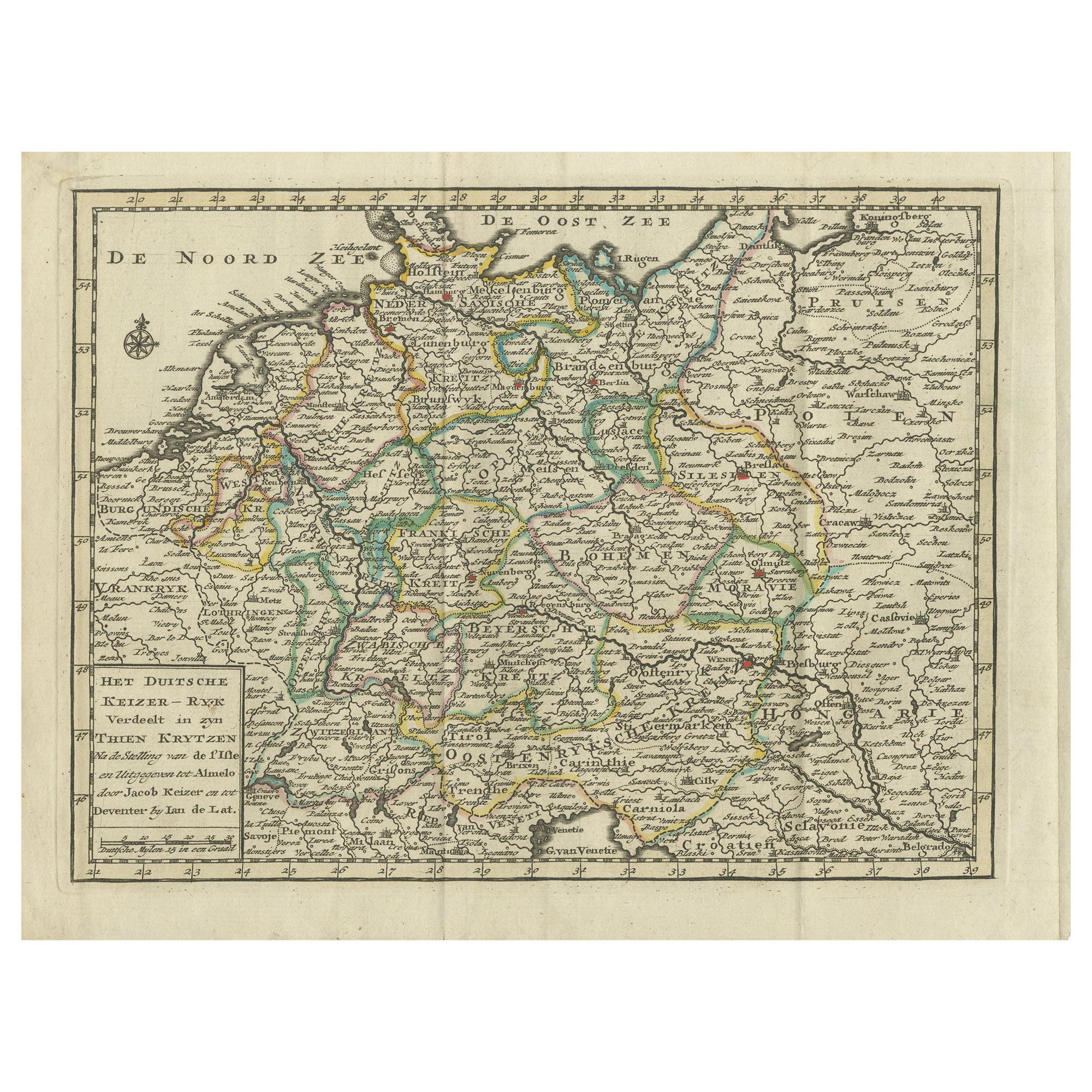
View AllAntique Map of the German Empire by Keizer & de Lat, 1788
Located in Langweer, NL
Antique map titled 'Het Duitsche Keizer-Ryk (..)'. Uncommon original antique map of the German Empire. This map originates from 'Nieuwe Natuur- Geschied- en Handelkundige Zak- en Rei...
Category
Antique Late 18th Century Maps
Materials
Paper
$335 Sale Price
20% Off
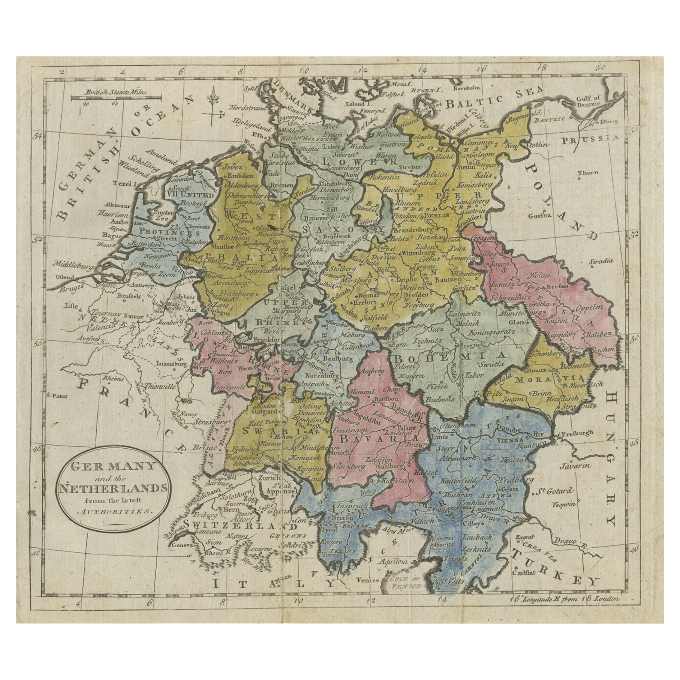
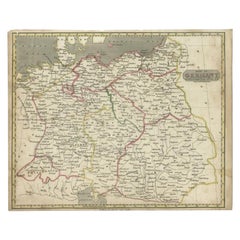
Antique Map of Germany, the Netherlands, Bohemia, Bavaria and Switzerland, 1785
Located in Langweer, NL
Antique map titled 'Germany and the Netherlands from the latest authorities'. Depicts Germany, the Netherlands and the surrounding region including Bohemia, Bavaria, and Switzerland....
Category
Antique 18th Century Maps
Materials
Paper
$134 Sale Price
20% Off
Antique Map of Germany During the Mid-18th Century, Published in 1747
Located in Langweer, NL
Antique map Germany titled 'A New & Accurate Map of Germany'. It covers Germany during the mid-18th century, which included all of modern day Germany, Austria, Switzerland, Czech Rep...
Category
Antique 18th Century Maps
Materials
Paper

$201 Sale Price
20% Off
Antique Map of Germany by Lapie, 1842
Located in Langweer, NL
Antique map titled 'Carte de la Germanie Ancienne'. Map of Germany. This map originates from 'Atlas universel de géographie ancienne et moderne (..)' by...
Category
Antique Mid-19th Century Maps
Materials
Paper

$479 Sale Price
20% Off
Antique Map of Germany by Clouet, 1787
Located in Langweer, NL
Antique map titled 'L'Allemagne'. Antique map of Germany. Originates from 'Geographie moderne avec une introduction' by J.B.L. Clouet.
Category
Antique Late 18th Century Maps
Materials
Paper

$383 Sale Price
20% Off
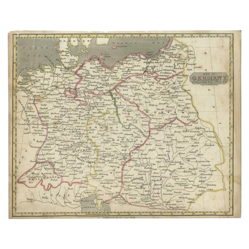
Antique Map of Germany by Walker, 1820
By R. Walker
Located in Langweer, NL
Antique map Germany titled 'Map of Germany as defined by the Peace of Paris'. Detailed antique map of Germany.
Artists and Engravers: Engrav...
Category
Antique 19th Century Maps
Materials
Paper
$62 Sale Price
20% Off
You May Also Like
17th Century Hand-Colored Map of a Region in West Germany by Janssonius
By Johannes Janssonius
Located in Alamo, CA
This attractive highly detailed 17th century original hand-colored map is entitled "Archiepiscopatus Maghdeburgensis et Anhaltinus Ducatus cum terris adjacentibus". It was published ...
Category
Antique Mid-17th Century Dutch Maps
Materials
Paper

German Empire, Northern Part. Century Atlas antique vintage map
Located in Melbourne, Victoria
'The Century Atlas. German Empire, Northern Part.'
Original antique map, 1903.
Central fold as issued. Map name and number printed on the reverse corne...
Category
Early 20th Century Victorian More Prints
Materials
Lithograph

18th Century Hand-Colored Homann Map of Germany, Including Frankfurt and Berlin
By Johann Baptist Homann
Located in Alamo, CA
An 18th century hand-colored map entitled "Tabula Marchionatus Brandenburgici et Ducatus Pomeraniae quae sunt Pars Septentrionalis Circuli Saxoniae Superioris" by Johann Baptist Homa...
Category
Antique Early 18th Century German Maps
Materials
Paper

1853 Map of "Russia in Europe Including Poland" Ric.r016
Located in Norton, MA
Description
Russia in Europe incl. Poland by J Wyld c.1853
Hand coloured steel engraving
Dimension: Paper: 25 cm W x 33 cm H ; Sight: 22 cm W x 28 cm H
Condition: Good ...
Category
Antique 19th Century Unknown Maps
Materials
Paper

1839 Map of Karte Des "Russischen Reiches in Europa Und Asien" Ric.R0013
Located in Norton, MA
1839 map of Karte Des
"Russischen Reiches in Europa and Asien"
Ric.r013
Map of the European and Asian parts of Russian Empire. Karte der Russischen Reiches in Europa und Asien...
Category
Antique 19th Century Unknown Maps
Materials
Paper

1790 Thomas Stackhouse Map, Entitled "Russia in Europe, " , Ric.a004
Located in Norton, MA
1790 Thomas Stackhouse map, entitled
"Russia in Europe"
Ric.a004
Stackhouse, Thomas
Russia in Europe [map]
London: T. Stackhouse, 1783. Map. Matted hand-colored copper engraving. Image size: 14.5 x 15.25 inches. Mat size: 22.75 x 23.75 inches. A beautiful example of this map of Eastern Europe...
Category
Antique 17th Century Unknown Maps
Materials
Paper

More Ways To Browse
Historical Documents
Antique Ancient Key
Bavarian Antique
Antique Level Tool
Antique Gallia
Silver Over Copper
Vintage Barware Glasses
Coffee Table Black Italian Modern
Christofle America
Iranian Silk Rug Carpet
Poul Moller
Tables With Inlaid Wood
World War Table
Antonio Jacobsen
Ariston Chairs
Coffee Tables Europe
Marble Top Dining Tables
Nordiska Argentina