Items Similar to Antique Map of the German Empire by Keizer & de Lat, 1788


Want more images or videos?
Request additional images or videos from the seller
1 of 5
Antique Map of the German Empire by Keizer & de Lat, 1788
About the Item
Antique map titled 'Het Duitsche Keizer-Ryk (..)'. Uncommon original antique map of the German Empire. This map originates from 'Nieuwe Natuur- Geschied- en Handelkundige Zak- en Reisatlas' by Gerrit Brender à Brandis. Published by J. Keizer and I. de Lat, 1788.
- Dimensions:Height: 8.08 in (20.5 cm)Width: 11.03 in (28 cm)Depth: 0.02 in (0.5 mm)
- Materials and Techniques:
- Period:
- Date of Manufacture:1788
- Condition:General age-related toning. Original folding lines. Original/contemporary hand coloring, blank verso. Minor wear, please study image carefully.
- Seller Location:Langweer, NL
- Reference Number:
About the Seller
5.0
Platinum Seller
These expertly vetted sellers are 1stDibs' most experienced sellers and are rated highest by our customers.
Established in 2009
1stDibs seller since 2017
1,932 sales on 1stDibs
Typical response time: <1 hour
- ShippingRetrieving quote...Ships From: Langweer, Netherlands
- Return PolicyA return for this item may be initiated within 14 days of delivery.
More From This SellerView All
- Antique Map of Switzerland by Keizer & de Lat, 1788Located in Langweer, NLAntique map titled 'La Suisse (..)'. Uncommon original antique map of Switzerland. This map originates from 'Nieuwe Natuur- Geschied- en Handelkundige Zak- en Reisatlas' by Gerrit Br...Category
Antique Late 18th Century Maps
MaterialsPaper
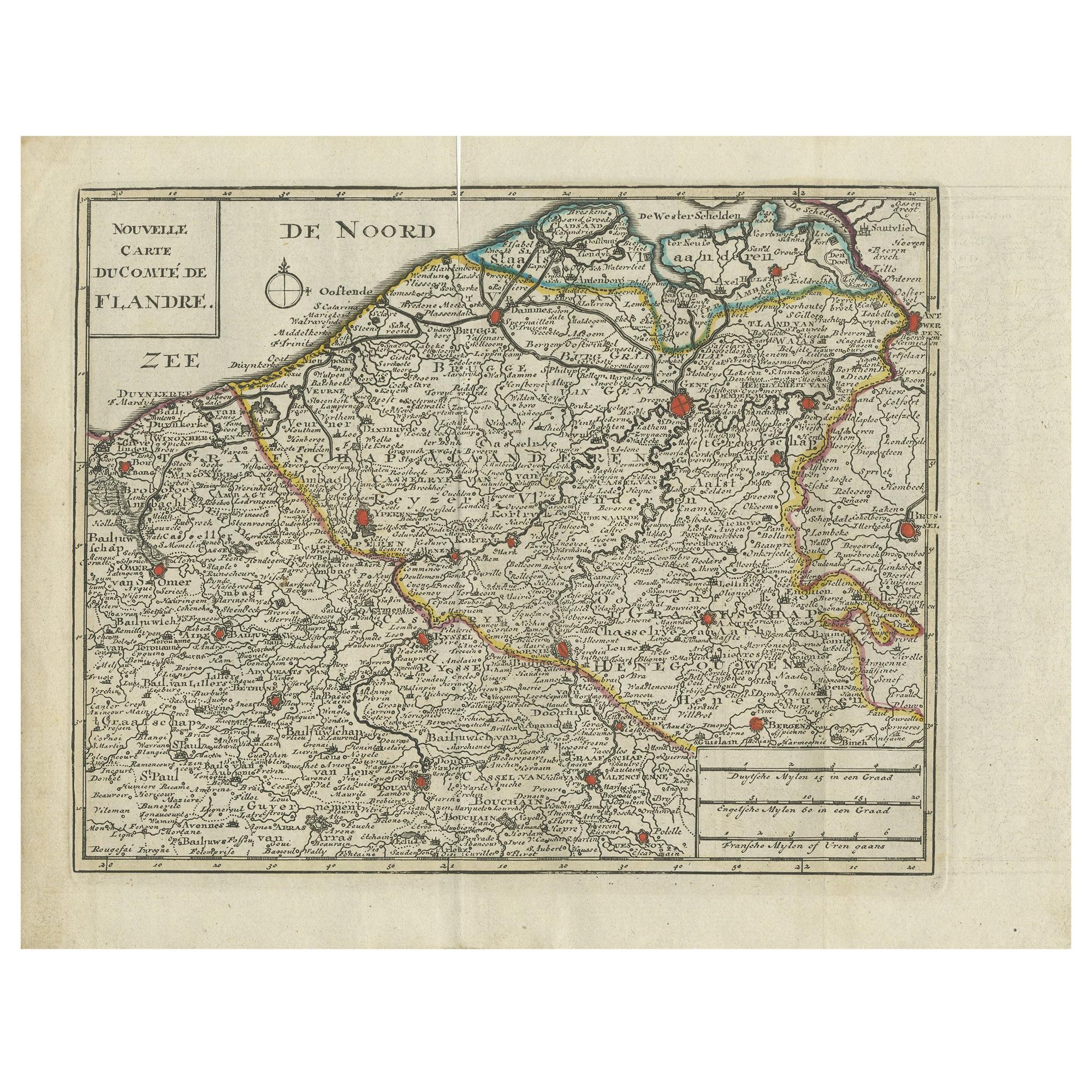
- Antique Map of Flanders by Keizer & de Lat, 1788Located in Langweer, NLAntique map titled 'Nouvelle Carte du Comté de Flandre'. Uncommon original antique map of Flanders, Belgium. This map originates from 'Nieuwe Natuur- Geschied- en Handelkundige Zak- ...Category
Antique Late 18th Century Maps
MaterialsPaper
- Antique Map of Africa by Keizer & de Lat, 1788Located in Langweer, NLAntique map titled 'Kaartje van Africa (..)'. Uncommon original antique map of Africa. This map originates from 'Nieuwe Natuur- Geschied- en Handelkundige Zak- en Reisatlas' by Gerri...Category
Antique Late 18th Century Maps
MaterialsPaper
- Antique Map of Greece by Keizer & de Lat, 1788Located in Langweer, NLAntique map titled 't Zuider Deel van Turks Europe genaamt Griekenland (..)'. Uncommon original antique map of Greece. This map originates from 'Nieuwe Natuur- Geschied- en Handelkun...Category
Antique Late 18th Century Maps
MaterialsPaper
- Antique Map of Europe by Keizer & de Lat, 1788Located in Langweer, NLAntique map titled 'Kaartje van Europa (..)'. Uncommon original antique map of Europe. This map originates from 'Nieuwe Natuur- Geschied- en Handelkundige Zak- en Reisatlas' by Gerri...Category
Antique Late 18th Century Maps
MaterialsPaper
- Antique Map of Italy by Keizer & de Lat, 1788Located in Langweer, NLAntique map titled 'Kaart van Italie (..)'. Uncommon original antique map of Italy. This map originates from 'Nieuwe Natuur- Geschied- en Handelk...Category
Antique Late 18th Century Maps
MaterialsPaper


You May Also Like
- Germany West of the Rhine: A Hand-colored 18th Century Map by de WitBy Frederick de WitLocated in Alamo, CAThis original 18th century hand-colored map of the county of Moers, Germany entitled "Illustrissimo Celsissmo Principi GUILIELMO HENRICO D.G. Arausionum Principi Domino suo Clementis...Category
Antique Early 18th Century Dutch Maps
MaterialsPaper
- Original Antique Map of The World by Thomas Clerk, 1817Located in St Annes, LancashireGreat map of The Eastern and Western Hemispheres On 2 sheets Copper-plate engraving Drawn and engraved by Thomas Clerk, Edinburgh. Published by Mackenzie And Dent, 1817 ...Category
Antique 1810s English Maps
MaterialsPaper
- Map of the Holy Land "Carte de la Syrie et de l'Egypte" by Pierre M. LapieBy Pierre M. LapieLocated in Alamo, CAAn early 19th century map of ancient Syria and Egypt entitled "Carte de la Syrie et de l'Egypte anciennes/dressée par M. Lapie, Colonel d'Etat Major, et...Category
Antique Early 19th Century French Maps
MaterialsPaper
- Original Antique Map of The Netherlands, Engraved by Barlow, Dated 1807Located in St Annes, LancashireGreat map of Netherlands Copper-plate engraving by Barlow Published by Brightly & Kinnersly, Bungay, Suffolk. Dated 1807 Unframed.Category
Antique Early 1800s English Maps
MaterialsPaper
- Map of the Republic of GenoaLocated in New York, NYFramed antique hand-coloured map of the Republic of Genoa including the duchies of Mantua, Modena, and Parma. Europe, late 18th century. Dimension: 25...Category
Antique Late 18th Century European Maps
- Antique Map of Italy by Andriveau-Goujon, 1843By Andriveau-GoujonLocated in New York, NYAntique Map of Italy by Andriveau-Goujon, 1843. Map of Italy in two parts by Andriveau-Goujon for the Library of Prince Carini at Palazzo Carini i...Category
Antique 1840s French Maps
MaterialsLinen, Paper


Recently Viewed
View AllMore Ways To Browse
Antique Empire De
German Empire Furniture
German Empire
Antique German Map
Antique German Maps
Antique Map Germany
Antique Maps Germany
Antique Map Of Germany
Antique Maps Of Germany
Antique Map German Empire
Antique Maps Buy
Portugal Antiques
Antique Geography
Dutch Map
Holland Map
Antique French Folding
Antique World Atlas
Fold Out Office