Items Similar to Historical Map of Greece and the Eastern Mediterranean by Delisle - 1780


Want more images or videos?
Request additional images or videos from the seller
1 of 11
Historical Map of Greece and the Eastern Mediterranean by Delisle - 1780
$278.21
$347.7620% Off
£206.96
£258.7020% Off
€232
€29020% Off
CA$380.96
CA$476.2020% Off
A$423.58
A$529.4820% Off
CHF 221.17
CHF 276.4620% Off
MX$5,156
MX$6,44520% Off
NOK 2,822.03
NOK 3,527.5420% Off
SEK 2,644.11
SEK 3,305.1420% Off
DKK 1,766.09
DKK 2,207.6120% Off
Shipping
Retrieving quote...The 1stDibs Promise:
Authenticity Guarantee,
Money-Back Guarantee,
24-Hour Cancellation
About the Item
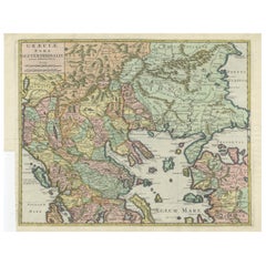
Historical Map of Greece and the Eastern Mediterranean by Guillaume Delisle - 1780 Reissue
This captivating map titled "Carte de la Grèce" was originally crafted by the eminent French cartographer Guillaume Delisle in 1707 and later reissued in 1780 under royal privilege. Delisle was one of the most prominent and influential geographers of his time, known for his precision and innovative approach to mapmaking. This map was published in Paris, and the 1780 edition reflects both the enduring value of Delisle's work and the continued interest in the region during the 18th century.
The map represents Greece and the surrounding regions of the Eastern Mediterranean, including parts of Turkey, the Balkans, and the Aegean Sea. Greece, Macedonia, Epirus, and the Morea (Peloponnese) are clearly delineated, along with the islands of Crete (Isle de Candie) and Cyprus (Isle de Chypre). The map also covers a substantial portion of the Balkans, including parts of present-day Bulgaria, Romania, and Turkey. Coastal cities and major inland towns are meticulously marked, showcasing Delisle’s dedication to cartographic accuracy.
The old hand coloring enhances the differentiation between territories, with shades of green, yellow, and red outlining regional boundaries. Delisle’s engraving style is characterized by crisp, clear lines and elegantly rendered topographical details, depicting mountains, rivers, and coastlines with remarkable precision. The lettering is meticulously engraved, adding a sense of sophistication and clarity.
One of the most striking features of this map is the beautifully ornate cartouche located in the lower left corner. Designed in the classic French Baroque style, the cartouche is framed by ancient architectural elements, including columns and an arch, symbolizing the classical heritage of Greece. Two allegorical figures, one symbolizing wisdom and the other strength, stand on either side, while a maritime motif with a ship’s prow and draped fabric adds a sense of grandeur and classical elegance.
The dedication on the cartouche indicates that the map was originally presented to the King in 1707 by the Abbé Delisle of the Royal Academy of Sciences. However, the map also bears the inscription "Avec Privilège du Roi 1780", indicating that this specific edition was published in 1780 under royal privilege. This reflects the long-lasting importance of Delisle's cartographic work and its continued relevance in the late 18th century.
The map was created using copperplate engraving, where the image was carefully incised onto a copper plate, inked, and pressed onto paper. The hand coloring was applied after printing, giving each piece a unique character and vibrancy.
Condition: The map is in fair condition, with well-preserved coloring. There are some light folds, age toning and repairs, especially in the lower middle fold, but they do not detract from the overall presentation.
Framing Tips: To showcase this beautiful piece, consider a classic dark wood frame with a gold or brass fillet to complement the ornate cartouche. A cream or light beige mat will enhance the map’s vibrant colors. Use UV-protective, non-reflective glass to preserve the map’s quality and protect against fading. Archival-quality materials are recommended for long-term preservation.
- Dimensions:Height: 19.69 in (50 cm)Width: 26.54 in (67.4 cm)Depth: 0.01 in (0.2 mm)
- Materials and Techniques:Paper,Engraved
- Period:1780-1789
- Date of Manufacture:1780
- Condition:Repaired: The area around the middle fold is repaired on the reverse with archival paper tape. Condition: The map is in fair condition, with well-preserved coloring. There are some light folds, age toning and repairs, especially in the lower middle fold, but they do not detract from the overall presentation.
- Seller Location:Langweer, NL
- Reference Number:Seller: BG-138431stDibs: LU3054344169322
About the Seller
5.0
Recognized Seller
These prestigious sellers are industry leaders and represent the highest echelon for item quality and design.
Platinum Seller
Premium sellers with a 4.7+ rating and 24-hour response times
Established in 2009
1stDibs seller since 2017
2,511 sales on 1stDibs
Typical response time: <1 hour
- ShippingRetrieving quote...Shipping from: Langweer, Netherlands
- Return Policy
Authenticity Guarantee
In the unlikely event there’s an issue with an item’s authenticity, contact us within 1 year for a full refund. DetailsMoney-Back Guarantee
If your item is not as described, is damaged in transit, or does not arrive, contact us within 7 days for a full refund. Details24-Hour Cancellation
You have a 24-hour grace period in which to reconsider your purchase, with no questions asked.Vetted Professional Sellers
Our world-class sellers must adhere to strict standards for service and quality, maintaining the integrity of our listings.Price-Match Guarantee
If you find that a seller listed the same item for a lower price elsewhere, we’ll match it.Trusted Global Delivery
Our best-in-class carrier network provides specialized shipping options worldwide, including custom delivery.More From This Seller
View AllAntique Map of Greece, Albania, Macedonia and Parts of Turkey and Cyprus, c.1745
Located in Langweer, NL
Antique map titled 'Accurata Totius Archipelagi Et Graeciae Universae Tabula'.
Detailed map of Greece. Includes Albania, Macedonia and parts of Turkey and Cyprus. With compass rose...
Category
Antique 18th Century Maps
Materials
Paper

$815 Sale Price
20% Off
Antique Map of Greece by Keizer & de Lat, 1788
Located in Langweer, NL
Antique map titled 't Zuider Deel van Turks Europe genaamt Griekenland (..)'. Uncommon original antique map of Greece. This map originates from 'Nieuwe Natuur- Geschied- en Handelkun...
Category
Antique Late 18th Century Maps
Materials
Paper

$335 Sale Price
20% Off
Antique Map of Greece by Allard (c.1698)
Located in Langweer, NL
Antique map titled 'Hellas seu Graecia Universa' Detailed map of Greece, with Crete, the Aegean Islands, and part of Turkey. With two cartouches, compass rose and scale. Carolus Alla...
Category
Antique Late 17th Century Maps
Materials
Paper

$940 Sale Price
20% Off
Antique Map of Greece by Seutter or Lotter, 'c.1740'
Located in Langweer, NL
Antique map titled 'Graecia pars Septentrionalis'. Original antique map of Greece, uncommon. Signed cum Gratia et Privil. S.R.I. Vicariatus (..)'. Published by Seutter or Lotter, cir...
Category
Antique Mid-18th Century Maps
Materials
Paper

$661 Sale Price
35% Off
Antique Map of Eastern Mediterranean and Asia Minor by a Benedictine, c.1725
Located in Langweer, NL
Antique map titled 'Byzondere Afbeelding der Landschappen, van de Apostelen bevaren en doorwandelt om het Evangelium J. C. te Prediken.' Map of the lands travelled by the Apostles to...
Category
Antique 18th Century Maps
Materials
Paper

$287 Sale Price
20% Off
Antique Engraved Map of the Northern Part of Greece and the Aegean Sea, Ca.1730
Located in Langweer, NL
Title: "GRÆCIÆ PARS Septentrionalis".
Hand Coloured Engraved map by G. Delisle of the northern part of the Aegean. In the top left corner a distance scale included.
Condition...
Category
Antique 1730s Maps
Materials
Paper
$623 Sale Price
20% Off
You May Also Like
Greece, "Graeciae Antiquae"" A 17th Century Hand-colored Map by Sanson
By Nicolas Sanson
Located in Alamo, CA
This is an original 17th century hand colored copperplate engraved map of Greece entitled "Graeciae Antiquae Tabula Hanc Geographicam" by Nicolas d'Abbeville Sanson, engraved and pub...
Category
Antique Mid-17th Century French Maps
Materials
Paper

Original Antique Map of Ancient Greece, Achaia, Corinth, 1786
Located in St Annes, Lancashire
Great map of Ancient Greece. Showing the region of Thessaly, including Mount Olympus
Drawn by J.D. Barbie Du Bocage
Copper plate engraving by P.F Tardieu
Original hand color...
Category
Antique 1780s French Other Maps
Materials
Paper

Hand-Colored 18th Century Homann Map of the Danube, Italy, Greece, Croatia
By Johann Baptist Homann
Located in Alamo, CA
"Fluviorum in Europa principis Danubii" is a hand colored map of the region about the Danube river created by Johann Baptist Homann (1663-1724) in his 'Atlas Novus Terrarum', publish...
Category
Antique Early 18th Century German Maps
Materials
Paper

Southern Greece: A Large 17th C. Hand-colored Map by Sanson and Jaillot
By Nicolas Sanson
Located in Alamo, CA
This large original hand-colored copperplate engraved map of southern Greece and the Pelopponese Peninsula entitled "La Moree Et Les Isles De Zante, Cefalonie, Ste. Marie, Cerigo & C...
Category
Antique 1690s French Maps
Materials
Paper

18th Century Map of the Southern Balkans by Giovanni Maria Cassini
By Giovanni Maria Cassini
Located in Hamilton, Ontario
18th century map by Italian engraver Giovanni Maria Cassini (Italy 1745-1824).
Map of the Southern Balkans: Rome. Hand colored and copper engraved print done in the year 1788. It in...
Category
Antique 18th Century Italian Maps
Materials
Paper

$795 Sale Price
36% Off
Southern & Eastern Europe: A Large 17th C. Hand-colored Map by Sanson & Jaillot
By Nicolas Sanson
Located in Alamo, CA
This large hand-colored map entitled "Estats de L'Empire des Turqs en Europe, ou sont les Beglerbeglicz our Gouvernements" was originally created by Nicholas Sanson d'Abbeville and t...
Category
Antique 1690s French Maps
Materials
Paper

More Ways To Browse
Mediterranean Antique
Engraving Greek
Engravings Greece
Greek Fabric
Middle Eastern Glass
Antique Turkey Plates
Greek Plate Classical
Antique Crete
Antique Turkish Brass
Copper Printing Plate
Middle Eastern Plate
Turkish Copper Plates
Vintage Scandanavian Chairs
19th Century Red Glass
Antique French Console Table Tables
Silver Bowl Large
Antique French Silk
Down Couch