Items Similar to Historical Map of Northern Europe and Russia - Engraved for I. Harrison, 1788


Want more images or videos?
Request additional images or videos from the seller
1 of 10
Historical Map of Northern Europe and Russia - Engraved for I. Harrison, 1788
$805.85
$1,007.3120% Off
£599.47
£749.3420% Off
€672
€84020% Off
CA$1,103.48
CA$1,379.3520% Off
A$1,226.92
A$1,533.6520% Off
CHF 640.63
CHF 800.7920% Off
MX$14,934.62
MX$18,668.2820% Off
NOK 8,174.17
NOK 10,217.7120% Off
SEK 7,658.81
SEK 9,573.5120% Off
DKK 5,115.56
DKK 6,394.4620% Off
Shipping
Retrieving quote...The 1stDibs Promise:
Authenticity Guarantee,
Money-Back Guarantee,
24-Hour Cancellation
About the Item
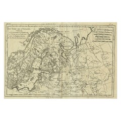
Historical Map of Northern Europe and Russia - Engraved for I. Harrison, 1788
This impressive historical map titled A New Map of Europe Containing Denmark, Norway, Sweden and Russia was engraved for I. Harrison in 1788, drawn from Danville’s two-sheet map. The map is based on the work of Jean Baptiste Bourguignon d'Anville, one of the most prominent French cartographers of the 18th century, known for his meticulous and accurate approach to mapmaking.
The map covers the vast territories of Northern Europe, including Denmark, Norway, Sweden, and Russia, as well as parts of Finland and the Baltic regions. An inset map in the upper left corner provides a detailed view of Iceland, carefully depicting its rugged coastline and geographical features. The map provides a comprehensive and detailed view of the political and administrative divisions of the time, illustrating a region that was both strategically significant and geographically diverse.
The map’s engraving style is characterized by clean, precise lines and well-organized labeling, typical of high-quality cartography of the late 18th century. Rivers, mountains, lakes, and major cities are meticulously depicted, and the old hand coloring enhances the distinction between national and regional boundaries, using shades of green, pink, yellow, and blue. This subtle coloring technique creates an elegant and informative visual presentation.
One of the most distinctive elements of the map is the title cartouche located at the upper right. The inscription reads:
A New Map of Europe
Containing Denmark, Norway, Sweden and Russia
Drawn from Danville’s two-sheet map
Engraved for I. Harrison
1788
This inscription acknowledges the map’s foundation on d'Anville’s cartographic work, highlighting the enduring influence of d'Anville’s precise geographical data. The map serves as a detailed representation of the northern European region at the end of the 18th century, reflecting the scientific and cartographic advancements of the Enlightenment period.
The map was created using copperplate engraving, a technique where the design was etched into a copper plate, inked, and pressed onto paper. The resulting prints were then meticulously hand-colored to enhance the visual distinction between political boundaries and geographical features.
Condition: The map is in good condition, with vibrant hand coloring and minimal signs of aging. Some light folds and minor toning are present, but these are typical for maps of this age and do not detract from its overall presentation. The paper is strong, and the engraving remains crisp and sharp.
Framing Tips: To highlight the historical charm of this map, choose a dark wooden frame with a gold or brass fillet to enhance the classic appeal. A light cream or beige mat will beautifully complement the map’s colors. Use UV-protective, non-reflective glass to preserve the map's vibrancy and protect against fading. Archival-quality materials are essential to maintain the map’s integrity and value over time.
- Dimensions:Height: 21.26 in (54 cm)Width: 30.52 in (77.5 cm)Depth: 0.01 in (0.2 mm)
- Materials and Techniques:Paper,Engraved
- Period:1780-1789
- Date of Manufacture:1788
- Condition:The map is in good condition, with vibrant hand coloring and minimal signs of aging. Some light folds and minor toning are present, but these are typical for maps of this age and do not detract from its overall presentation. The paper is strong.
- Seller Location:Langweer, NL
- Reference Number:Seller: BG-13840-111stDibs: LU3054344169352
About the Seller
5.0
Recognized Seller
These prestigious sellers are industry leaders and represent the highest echelon for item quality and design.
Platinum Seller
Premium sellers with a 4.7+ rating and 24-hour response times
Established in 2009
1stDibs seller since 2017
2,510 sales on 1stDibs
Typical response time: <1 hour
- ShippingRetrieving quote...Shipping from: Langweer, Netherlands
- Return Policy
Authenticity Guarantee
In the unlikely event there’s an issue with an item’s authenticity, contact us within 1 year for a full refund. DetailsMoney-Back Guarantee
If your item is not as described, is damaged in transit, or does not arrive, contact us within 7 days for a full refund. Details24-Hour Cancellation
You have a 24-hour grace period in which to reconsider your purchase, with no questions asked.Vetted Professional Sellers
Our world-class sellers must adhere to strict standards for service and quality, maintaining the integrity of our listings.Price-Match Guarantee
If you find that a seller listed the same item for a lower price elsewhere, we’ll match it.Trusted Global Delivery
Our best-in-class carrier network provides specialized shipping options worldwide, including custom delivery.More From This Seller
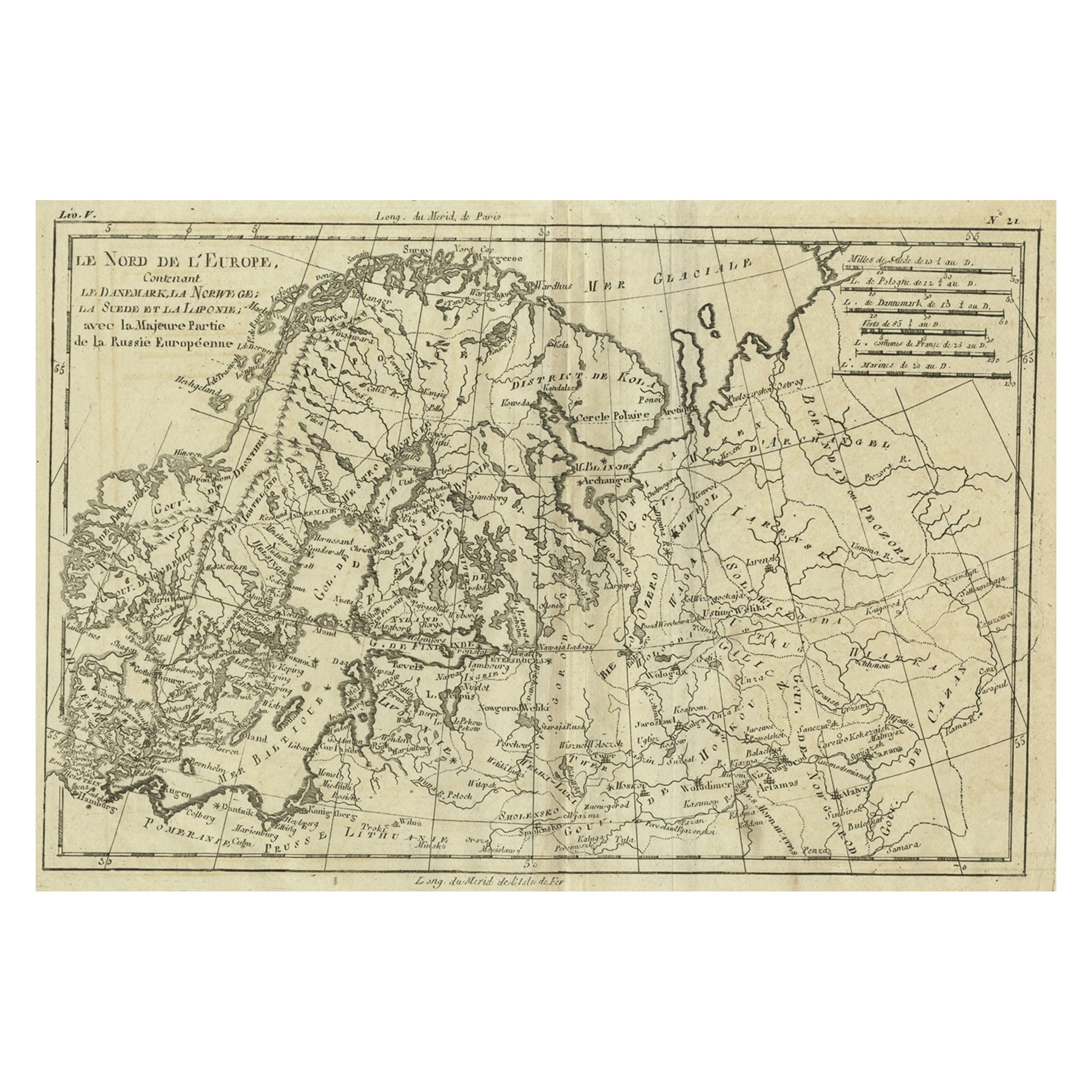
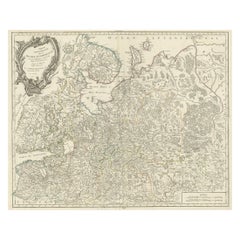
View AllAntique Map of Northern Europe and European Russia, ca.1780
Located in Langweer, NL
Antique map titled 'Le Nord de L'Europe, Contenant Le Danemark, La Norwege; La Suede et La Laponie avec la Majeure Partie de al Russie Europeenne.'
Map of Northern Europe and Eur...
Category
Antique 1780s Maps
Materials
Paper
$182 Sale Price
20% Off
Antique Map of Scandinavia by T. Jefferys, circa 1750
Located in Langweer, NL
Antique map titled 'Sweden, Denmark, Norway & Finland'. An original mid-18th century copper engraved antique map of Scandinavia by Thomas Jefferys....
Category
Antique Mid-18th Century Maps
Materials
Paper

$182 Sale Price
20% Off
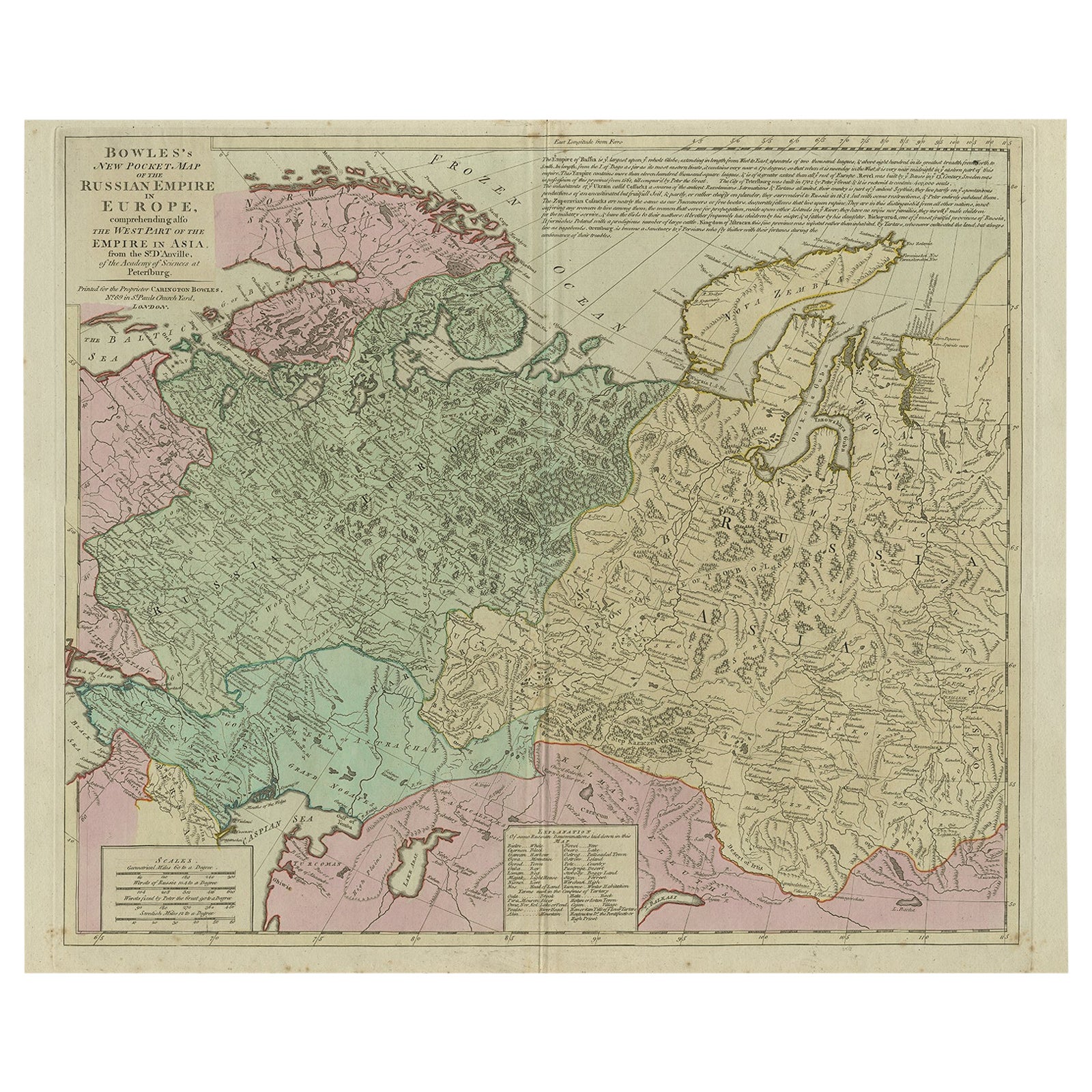
Antique Map of the Russian Empire in Europe, ca.1780
Located in Langweer, NL
Description: Antique map titled 'Bowles's New Pocket Map of the Russian Empire in Europe, Comprehending the West Part of the Empire in Asia' Large and detai...
Category
Antique 1780s Maps
Materials
Paper

$815 Sale Price
20% Off
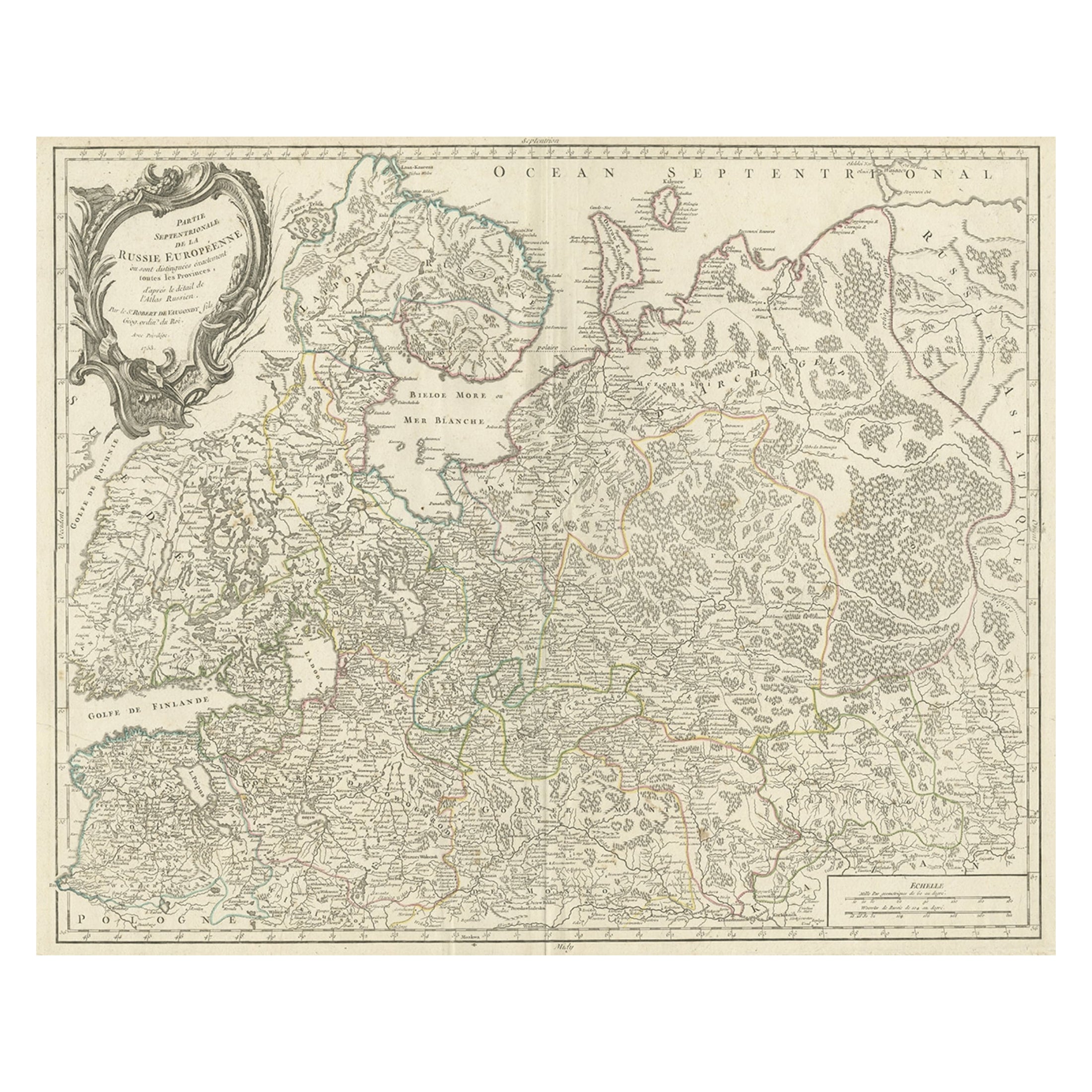
Original Antique Map of the Northwestern Part of Russia in Europe, 1753
Located in Langweer, NL
Antique map titled 'Partie septentrionale de la Russie Européenne'.
Detailed map of the Northwestern part of Russia, from the Gulf of Finland and Poland, to the western part of Asian Russia.
Artists and Engravers: Gilles Robert de Vaugondy (1688-1766) was the head of a leading family of geographers in eighteenth century France. Gilles got his start when he jointly inherited the shop of Pierre-Moullart Sanson, grandson of the famous geographer Nicholas Sanson. The inheritance included the business, its stock of plates, and a roller press...
Category
Antique 1750s Maps
Materials
Paper
$566 Sale Price
20% Off
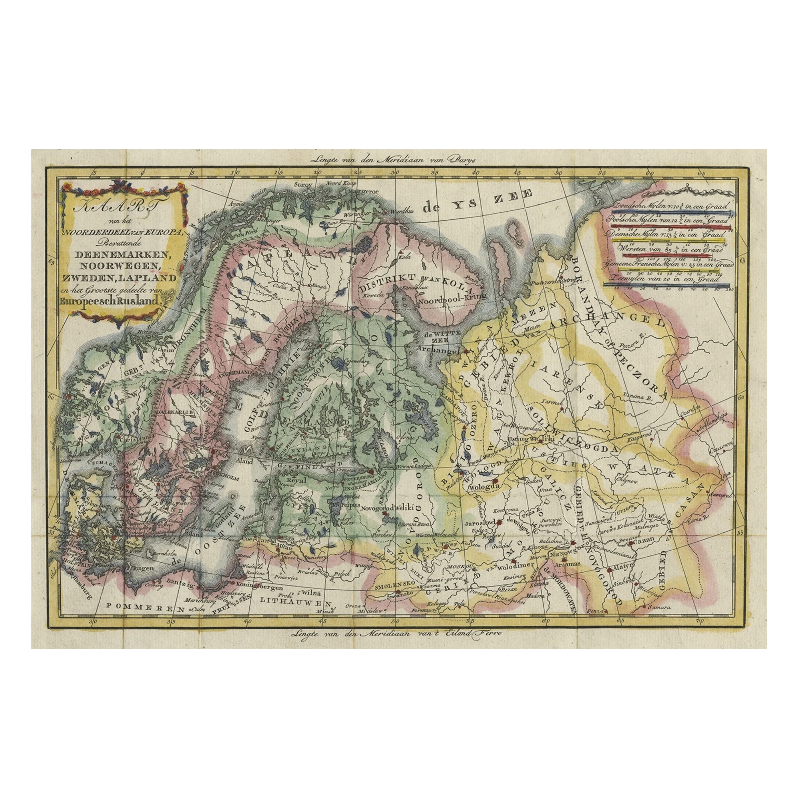
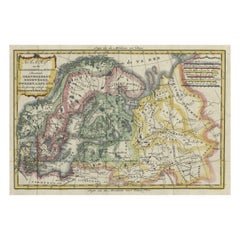
Uncommon Old Map of Lapland to Russia and Denmark to Kazan in the South, 1785
Located in Langweer, NL
Description: Antique map titled 'Kaart van het Noorderdeel van Europa, Bevattende Deenmarken, Noorwegen, Zweden, Lapland en het Grootste Gedeelte van Europeesch Rusland.'
This un...
Category
Antique 1780s Maps
Materials
Paper
$527 Sale Price
20% Off
Antique Map of Sweden by Bowen, 1747
Located in Langweer, NL
Antique map titled 'A New & Accurate Map of Sweden'. This map covers Sweden and Finland (shown as part of Sweden) as well as parts of modern day Estonia,...
Category
Antique 18th Century Maps
Materials
Paper

$259 Sale Price
20% Off
You May Also Like
Original Antique Map of Sweden, Engraved by Barlow, 1806
Located in St Annes, Lancashire
Great map of Sweden
Copper-plate engraving by Barlow
Published by Brightly & Kinnersly, Bungay, Suffolk. 1806
Unframed.
Category
Antique Early 1800s English Maps
Materials
Paper

Scandinavia & Portions of Eastern Europe: 18th Century Hand-Colored Homann Map
By Johann Baptist Homann
Located in Alamo, CA
An early 18th century hand-colored copper-plate map entitled "Regni Sueciae in omnes suas Subjacentes Provincias accurate divisi Tabula Generalis" by Johann Baptist Homann (1663-1724...
Category
Antique Early 18th Century German Maps
Materials
Paper

1790 Thomas Stackhouse Map, Entitled "Russia in Europe, " , Ric.a004
Located in Norton, MA
1790 Thomas Stackhouse map, entitled
"Russia in Europe"
Ric.a004
Stackhouse, Thomas
Russia in Europe [map]
London: T. Stackhouse, 1783. Map. Matted hand-colored copper engraving. Image size: 14.5 x 15.25 inches. Mat size: 22.75 x 23.75 inches. A beautiful example of this map of Eastern Europe...
Category
Antique 17th Century Unknown Maps
Materials
Paper

Original Antique Map of Europe, Arrowsmith, 1820
Located in St Annes, Lancashire
Great map of Europe
Drawn under the direction of Arrowsmith.
Copper-plate engraving.
Published by Longman, Hurst, Rees, Orme and Brown, 1820
...
Category
Antique 1820s English Maps
Materials
Paper

Von Reilly Map of the Russian Empire, 1796
Located in Savannah, GA
A map of the Russian Empire in Europe by Von Reilly. Published in Vienna, 1796.
32 inches wide by 24 ½ inches tall
Category
Antique 1790s Austrian Prints
Materials
Glass, Wood, Paper

Sweden & Adjacent Portions of Scandinavia: A Hand-Colored 18th C. Map by Homann
By Johann Baptist Homann
Located in Alamo, CA
This hand-colored map of Sweden and adjacent portions of Scandinavia entitled "Regni Sueciae in Omnes suas Subjacentes Provincias accurate divisi Tabula Generalis" was created by Joh...
Category
Antique 1720s German Maps
Materials
Paper

More Ways To Browse
Antique Swedish Copper
Iceland Antique
Icelandic Antique
18th Century Norwegian
Danish Prints 18th Century
Swedish Wooden Plates
Vintage Scandanavian Chairs
19th Century Red Glass
Antique French Console Table Tables
Silver Bowl Large
Antique French Silk
Down Couch
Used Lighter Art
Blue Edge Glass
Mahogany 1950s Furniture
Solid Mahogany Table
Dessert Glasses
Geometric Glass Table