Items Similar to Impressive Decorative Engraved Map of the Red Sea and Arabian Peninsula, 1787


Want more images or videos?
Request additional images or videos from the seller
1 of 10
Impressive Decorative Engraved Map of the Red Sea and Arabian Peninsula, 1787
$1,619.89
$2,024.8620% Off
£1,205.90
£1,507.3820% Off
€1,352
€1,69020% Off
CA$2,218.84
CA$2,773.5620% Off
A$2,467.84
A$3,084.8020% Off
CHF 1,288.63
CHF 1,610.7920% Off
MX$30,030.98
MX$37,538.7320% Off
NOK 16,457.76
NOK 20,572.2020% Off
SEK 15,434.48
SEK 19,293.0920% Off
DKK 10,292.30
DKK 12,865.3820% Off
Shipping
Retrieving quote...The 1stDibs Promise:
Authenticity Guarantee,
Money-Back Guarantee,
24-Hour Cancellation
About the Item
This map, titled "Karte des arabischen Meerbusens oder des Rothen Meeres," is an original engraving from 1787 created by F. A. Schraembl, based on the cartographic work of d'Anville.
It is a partially colored copper engraving.
Key features and notable details of the map include:
1. The title is prominently displayed within a large, ornate cartouche, enhancing the aesthetic appeal and indicating the map's subject as the Red Sea (Rothen Meeres).
2. The map covers the Red Sea and its surrounding regions, including significant portions of the Arabian Peninsula and northeastern Africa.
3. There are two detailed inset maps:
- The first inset map shows the roadstead of the port of Suez (Rheede des Hafen von Sues).
- The second inset map depicts Bahr el Kolsum, the northwestern arm of the Red Sea, based on a map by De la Rochette from 1785.
4. Geographical Features: The map meticulously details the coastline, islands, and notable port cities along the Red Sea. The cartography highlights both natural and man-made features, with elevations and mountains represented through hachures.
5. Condition and Preservation: The map has a horizontal centerfold and is partially backed to prevent tears. The edges of the map sheet show minor holes, tears, and faint brown spots, yet it remains in overall good condition considering its age.
6. Historical Importance: This map is a valuable historical document, reflecting the cartographic knowledge of the late 18th century. It serves as a significant piece for collectors interested in antique maps, particularly those focusing on the Arabian Peninsula and maritime navigation in the Red Sea region.
The map shows the coastline of the Red Sea and the Arabian Peninsula, detailing regions and places along the western coast of Saudi Arabia and Yemen, as well as the eastern coast of Egypt and Sudan. Here are some of the most important places identified on the map:
1. Jeddah (Gedda): A major city and port on the western coast of Saudi Arabia, significant for its role as a gateway for pilgrims traveling to Mecca.
2. Mecca (Mekka): A holy city in Islam, located inland from the Red Sea, important for being the site of pilgrimage (Hajj) for Muslims.
3. Medina (Medina): Another important Islamic city, known for the Prophet's Mosque and being a key pilgrimage site.
4. Suez (Suess): Located at the northern end of the Red Sea, near the Suez Canal, it's a crucial link between the Mediterranean Sea and the Red Sea.
5. Aden: A port city in Yemen, located at the southern tip of the Arabian Peninsula, historically significant as a trading hub.
6. Mocha (Mokka): A port city in Yemen, historically known for being a major marketplace for coffee.
7. Sana'a: The capital city of Yemen, noted for its historical and cultural significance.
8. Bab el Mandeb: The strait connecting the Red Sea to the Gulf of Aden, crucial for maritime navigation.
These locations are critical due to their historical, religious, and economic significance, especially in terms of trade routes and pilgrimage sites. The map also illustrates the mountainous terrain and coastal features of the region.
The condition and preservation status, which, despite minor imperfections, is considered well-preserved for its age.
Overall, this map is a rare and valuable artifact, offering both historical insights and aesthetic appeal for collectors and enthusiasts of antique cartography.
- Dimensions:Height: 30.71 in (78 cm)Width: 22.64 in (57.5 cm)Depth: 0.01 in (0.2 mm)
- Materials and Techniques:Paper,Engraved
- Period:1780-1789
- Date of Manufacture:1787
- Condition:The map has a horizontal centerfold and is partially backed to prevent tears. The edges of the map sheet show minor holes, tears, and faint brown spots, yet it remains in overall good condition considering its age.
- Seller Location:Langweer, NL
- Reference Number:Seller: BG-13739-21stDibs: LU3054340300302
About the Seller
5.0
Recognized Seller
These prestigious sellers are industry leaders and represent the highest echelon for item quality and design.
Platinum Seller
Premium sellers with a 4.7+ rating and 24-hour response times
Established in 2009
1stDibs seller since 2017
2,508 sales on 1stDibs
Typical response time: <1 hour
- ShippingRetrieving quote...Shipping from: Langweer, Netherlands
- Return Policy
Authenticity Guarantee
In the unlikely event there’s an issue with an item’s authenticity, contact us within 1 year for a full refund. DetailsMoney-Back Guarantee
If your item is not as described, is damaged in transit, or does not arrive, contact us within 7 days for a full refund. Details24-Hour Cancellation
You have a 24-hour grace period in which to reconsider your purchase, with no questions asked.Vetted Professional Sellers
Our world-class sellers must adhere to strict standards for service and quality, maintaining the integrity of our listings.Price-Match Guarantee
If you find that a seller listed the same item for a lower price elsewhere, we’ll match it.Trusted Global Delivery
Our best-in-class carrier network provides specialized shipping options worldwide, including custom delivery.More From This Seller
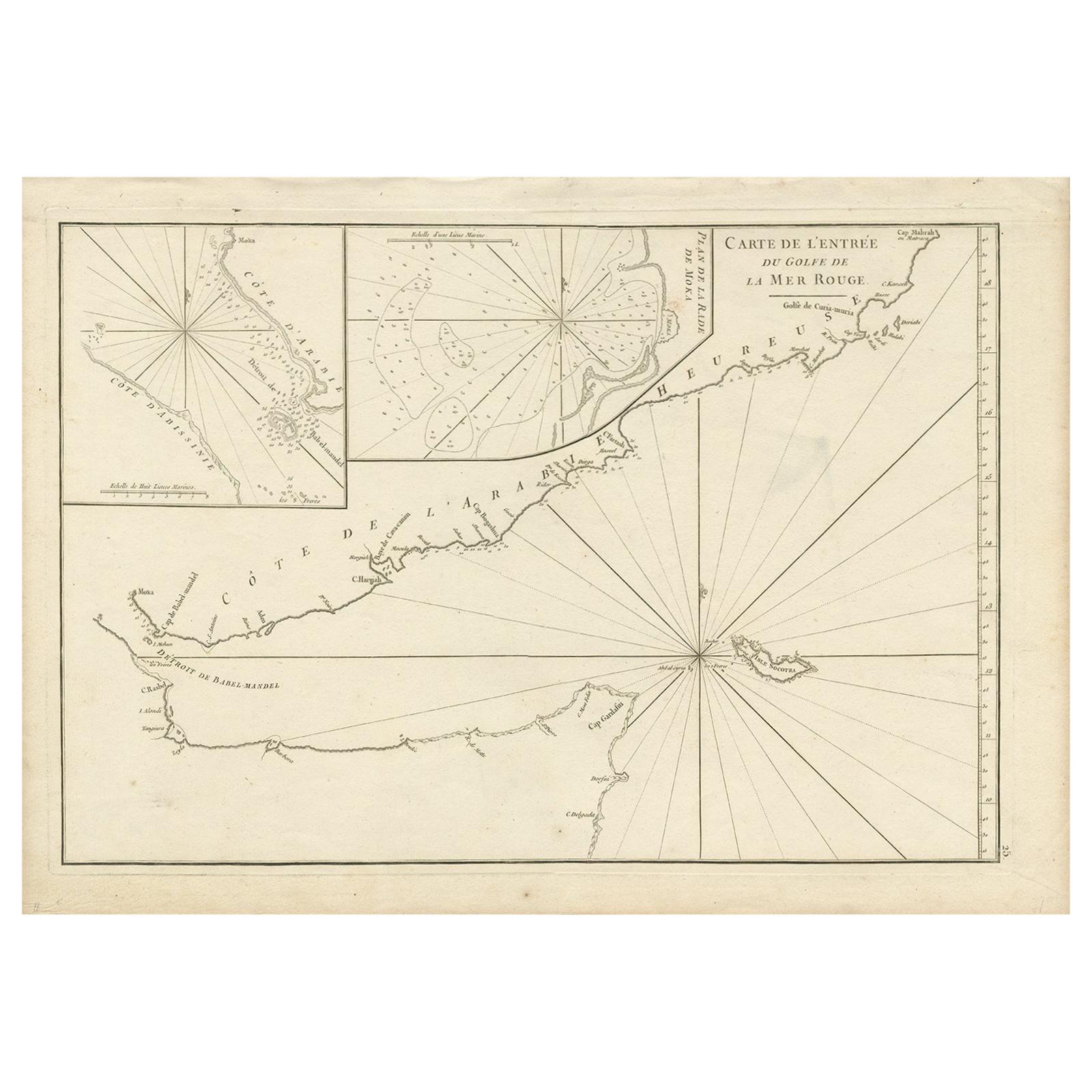
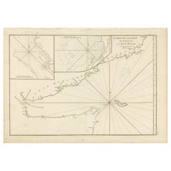
View AllOriginal Antique Engraved Map of Part of the Red Sea, Arabia, 1775
Located in Langweer, NL
Antique map titled 'Carte de l'Entrée du Golfe de la Mer Rouge'. Uncommon sea chart of the entrance to the Red Seas as far as Mocha, with rhumb lines and soundings. Two insets of the...
Category
Antique Late 18th Century Maps
Materials
Paper
$455 Sale Price
20% Off
Antique Map of the Arabian Peninsula by Bellin 'c.1740'
Located in Langweer, NL
Antique map titled 'Carte de la Coste d'Arabie, Mer Rouge et Golfe de Perse'. Original antique map of the Arabian Peninsula, labes both Mecca and Med...
Category
Antique Mid-18th Century Maps
Materials
Paper

$479 Sale Price
20% Off
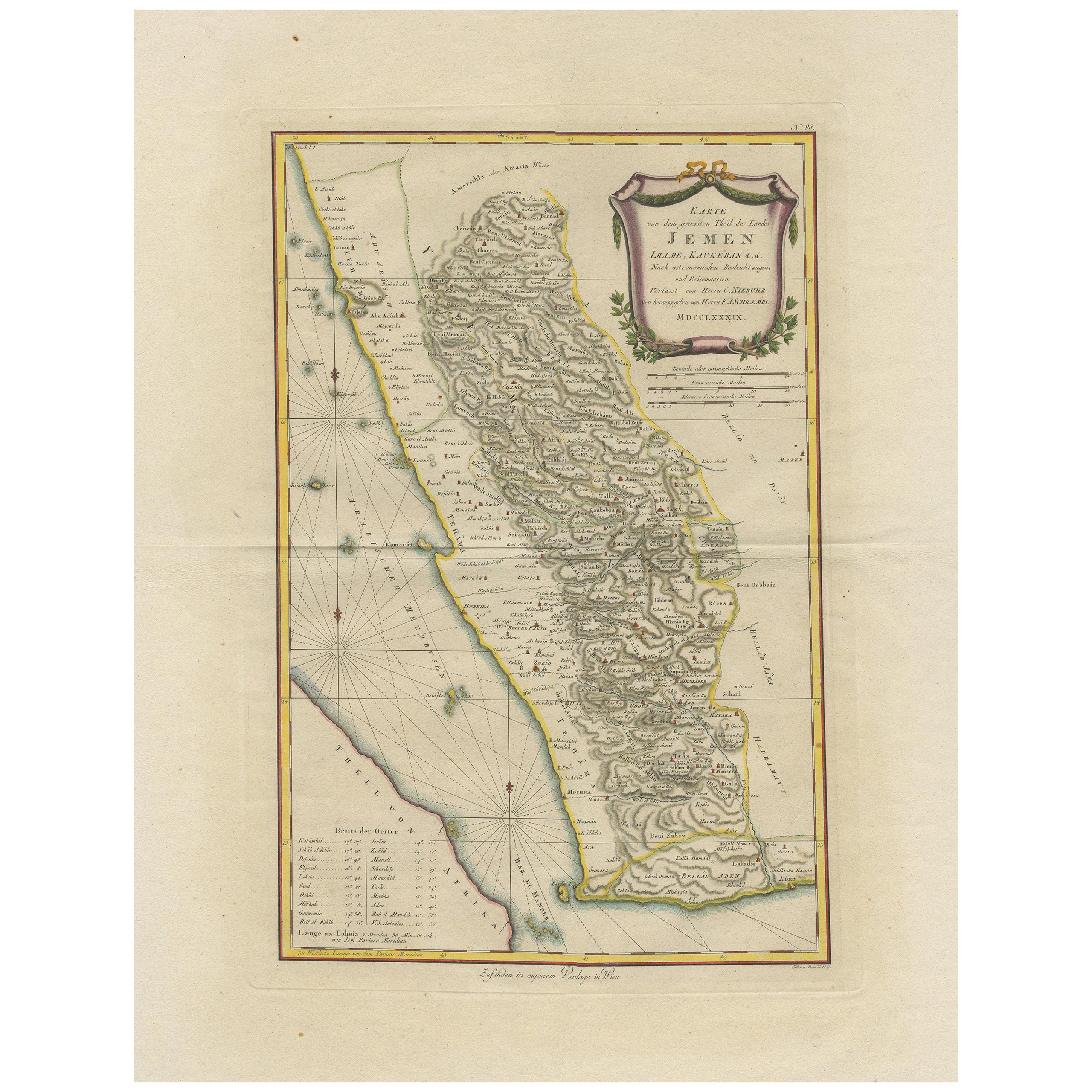
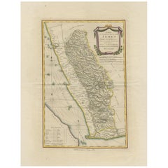
Antique Map of Yemen by Schraembl, 1789
Located in Langweer, NL
Antique map titled 'Karte von dem groessten Theil des Landes Jemen'. Original map of Yemen, this map is the first printed map specifically of Yemen, and t...
Category
Antique Late 18th Century Maps
Materials
Paper
$862 Sale Price
20% Off
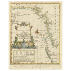
Antique Map of The Nile, Egypt and the Red Sea by Bachiene, 1765
Located in Langweer, NL
Antique map titled 'De XIde Landkaart verbeeldende Egypte en de Woestyne der Schelf-Zee (..).' Map of Biblical Egypt and the Red Sea. With title cartouche, compass rose and scale. Th...
Category
Antique 18th Century Maps
Materials
Paper

$167 Sale Price
20% Off
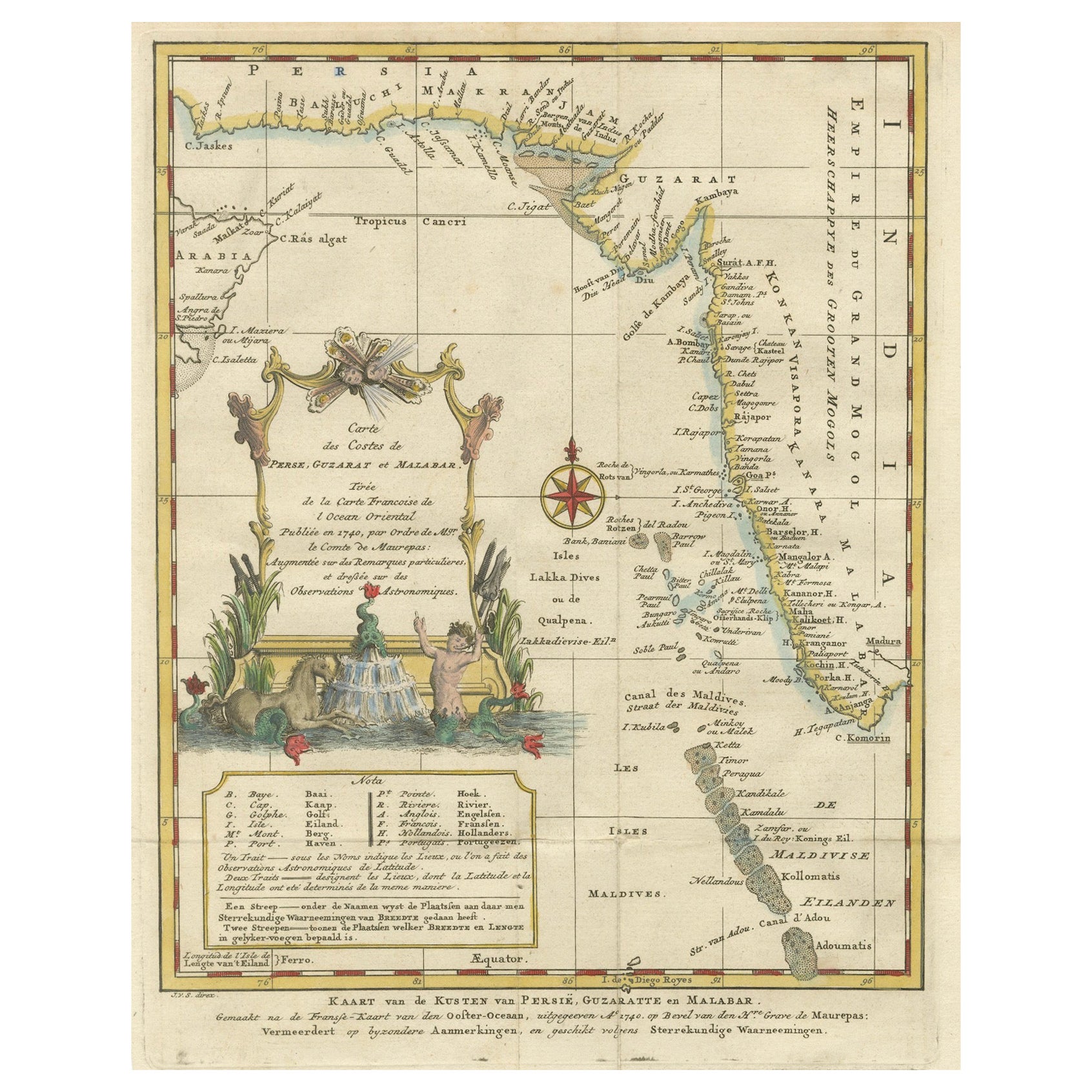
1773 Map of Persia, Gujarat & Malabar Coasts – Arabia to India, Hand-Colored
Located in Langweer, NL
1773 Bellin map of Persia, Gujarat and Malabar coasts with Arabia and Maldives
Description:
This finely engraved and delicately hand-colored 18th-century map titled Kaart van de Kusten van Persië, Guzaratte en Malabar was produced by the eminent French cartographer Jacques-Nicolas Bellin and engraved by Jakob van der Schley. It was published in 1773 in Amsterdam by E. van Harrevelt and D. Changuion, as part of a Dutch edition of Bellin’s maritime atlas focused on the East Indies and the Indian Ocean.
The map presents the coastline bordering the Arabian Sea, extending from the Persian Gulf and parts of the Arabian Peninsula to the shores of Gujarat and the Malabar Coast in southwestern India. It provides a detailed representation of the coastlines of Persia (modern-day Iran), the western coast of India, and a portion of southern Arabia including the Oman Peninsula. Coastal towns, rivers, ports, and geographical landmarks are clearly labeled, including prominent trading centers like Surat, Goa, Calicut, Cochin, and Cape Comorin (now Kanyakumari).
Additionally, the map shows the Laccadive Islands (Laka Dives) and the Maldives (Maldivische Eilanden), with attention to navigational details such as shoals, sandbanks, and anchor points. A large compass rose and clear latitude and longitude markings enhance its utility as a navigational aid.
A highly decorative title cartouche at lower left features maritime iconography such as sea creatures, a fountain, and shells. An inset legend beneath the map provides explanations in Dutch for the symbols used to indicate bays, capes, ports, forts, islands, and towns.
This is a copperplate engraving printed on laid paper with full original hand coloring. It retains its original fold lines as issued. The condition is generally good, with minor age toning and a few light spots in the margins. No repairs or restoration are visible. The paper is strong, and the impression remains crisp and clear.
This historical map is a significant and attractive example of 18th-century European cartography, especially valued for its depiction of maritime trade regions and coastal geography during the age of exploration and colonial expansion.
To frame this 1773 Bellin map attractively and safely:
- Use acid-free matting in a neutral tone like cream or antique white
- Consider double matting with a subtle inner color that complements the map
- Choose a simple wooden frame in walnut, cherry, or aged oak for a classic look
- Use UV-protective glass or acrylic to prevent fading
- For a full display, consider float mounting to show the edges and fold lines
- Allow 2 to 3 inch mat margins to balance the composition and enhance presentation
Keywords:
Bellin map 1773, van der Schley, Persia coast map, Gujarat map, Malabar map...
Category
Antique 1780s Maps
Materials
Paper
$325 Sale Price
20% Off
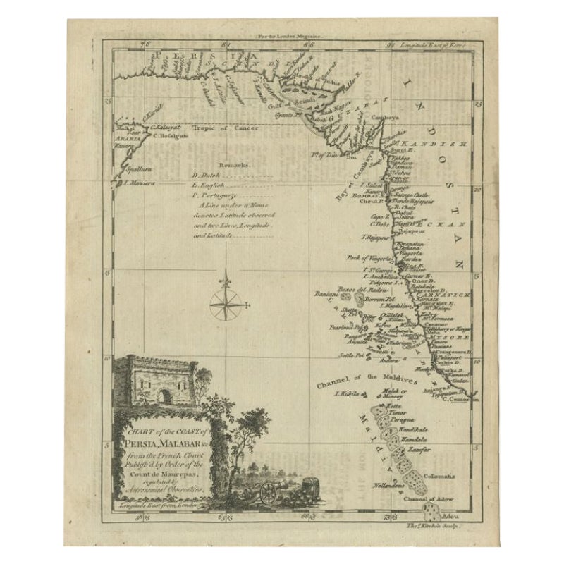
Antique Map of the Coast of Southwest Asia by Kitchin, c.1770
By Thomas Kitchin
Located in Langweer, NL
Antique map titled 'Chart of the Coast of Persia, Malabar & c'. Antique map of the coast of Southwest Asia. It shows the Maldives and part of Persia and India. Published for the 'Lon...
Category
Antique 18th Century Maps
Materials
Paper

$108 Sale Price
20% Off
You May Also Like
West Coast of Africa, Guinea & Sierra Leone: An 18th Century Map by Bellin
By Jacques-Nicolas Bellin
Located in Alamo, CA
Jacques Bellin's copper-plate map entitled "Partie de la Coste de Guinee Dupuis la Riviere de Sierra Leona Jusquau Cap das Palmas", depicting the coast of Guinea and Sierra Leone in ...
Category
Antique Mid-18th Century French Maps
Materials
Paper

Map of Nubia and Abissinia - Original Etching by Antonio Zatta - 1784
Located in Roma, IT
This Map of Nubia and Abissinia is an etching realized by Antonio Zatta in Venice in 1784.
The state of preservation of the artwork is good expect for the worn paper with some littl...
Category
1770s Landscape Prints
Materials
Etching

Antique French Map of Asia Including China Indoneseia India, 1783
Located in Amsterdam, Noord Holland
Very nice map of Asia. 1783 Dedie au Roy.
Additional information:
Country of Manufacturing: Europe
Period: 18th century Qing (1661 - 1912)
Condition: Overall Condition B (Good Used)...
Category
Antique 18th Century European Maps
Materials
Paper

$648 Sale Price
20% Off
Map of the Holy Land "Carte de la Syrie et de l'Egypte" by Pierre M. Lapie
By Pierre M. Lapie
Located in Alamo, CA
An early 19th century map of ancient Syria and Egypt entitled "Carte de la Syrie et de l'Egypte anciennes/dressée par M. Lapie, Colonel d'Etat Major, et...
Category
Antique Early 19th Century French Maps
Materials
Paper

Original Antique Map of Ancient Greece- Boeotia, Thebes, 1787
Located in St Annes, Lancashire
Great map of Ancient Greece. Showing the region of Boeotia, including Thebes
Drawn by J.D. Barbie Du Bocage
Copper plate engraving by P.F T...
Category
Antique 1780s French Other Maps
Materials
Paper

Antique Map of California as an Island "The 5 Californias" by Robert de Vaugondy
Located in San Diego, CA
A very nice and rare antique map entitled "Carte de la Californie Suivant" (The 5 Californias), by Didier Robert de Vaugondy of Paris, circa 1772. The map itself measures 15.5" x 13...
Category
Antique Mid-19th Century American Maps
Materials
Paper

More Ways To Browse
Arabian Antique
Islamic Engraved
Antique Marketplace
Antique Copper Coffee
Egyptian Cartouche
Antique Yemen
Antique Oushak Carpets
Blue Coffee Tables
1945 Chair Juhl
Antique Three Leg Table
Folke Arstrom
Silver Over Copper
Vintage Barware Glasses
Antique Etched Glass
Antique French Shell
Coffee Table Black Italian Modern
Christofle America
Iranian Silk Rug Carpet