Items Similar to Large Antique Lithography Map, Northamptonshire, Framed Cartography, John Speed


Want more images or videos?
Request additional images or videos from the seller
1 of 13
Large Antique Lithography Map, Northamptonshire, Framed Cartography, John Speed
$1,657.90
£1,210
€1,411.40
CA$2,270.91
A$2,525.75
CHF 1,318.87
MX$30,735.67
NOK 16,843.95
SEK 15,796.65
DKK 10,533.82
Shipping
Retrieving quote...The 1stDibs Promise:
Authenticity Guarantee,
Money-Back Guarantee,
24-Hour Cancellation
About the Item
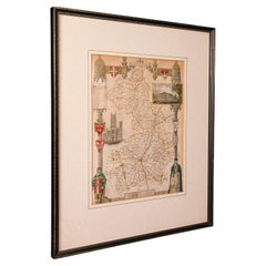
This is a large antique lithography map of Northamptonshire. An English, framed atlas engraving of cartographic interest by John Speed, dating to the early 17th century and later.
Superb lithography reproduction of Northamtonshire - place names are written in 17th century English
Displays a desirable aged patina and in very good order
Fascinating Jacobean period cartography, set within a quality, later frame
Reproduced here from its appearance in the 'Theatre of Great Britain' of 1627 published by George Humble
Marked for John Speed as cartographer and George Humbell (sic) as seller
Exceptional detail, as expected from a John Speed map, with town plans and heraldry
Wonderful town plan excerpts for Northampton and Peterborow with key for places of interest
Displays the coats of arms for each family granted Earlship in the county since the Norman conquest
Contains a vignette of text detailing the Battle of Edgecote Moor from the War of the Roses
Also presents text detailing events from 1263 and 1459 respectively
The reverse presents two pages from the atlas, representing the Hundreds of the county
Also hosting a list of names given for notable people within the county
Opposite page is dedicated to a history of the county
Dressed to the rear with hanging cord for ease of mounting
This is a brilliant antique lithography map of Northamptonshire, with fine cartographic interest and graced with a captivating level of detail. Delivered ready to display.
Dimensions:
Max Width: 72.5cm (28.5'')
Max Depth: 3cm (1.25'')
Max Height: 61.5cm (24.25'')
Front Map Width: 51cm (20'')
Front Map Height: 39.5cm (15.5'')
Rear Panel Width: 51cm (20'')
Rear Panel Height: 39.5cm (15.5'')
- Dimensions:Height: 24.22 in (61.5 cm)Width: 28.55 in (72.5 cm)Depth: 1.19 in (3 cm)
- Style:Other (Of the Period)
- Materials and Techniques:
- Place of Origin:
- Period:Mid-17th Century
- Date of Manufacture:circa 1630
- Condition:Wear consistent with age and use. Presented in very good antique condition.
- Seller Location:Hele, Devon, GB
- Reference Number:Seller: 244291stDibs: LU2645340678952
About the Seller
5.0
Platinum Seller
Premium sellers with a 4.7+ rating and 24-hour response times
Established in 2005
1stDibs seller since 2017
1,031 sales on 1stDibs
Typical response time: 1 hour
- ShippingRetrieving quote...Shipping from: Hele, Devon, United Kingdom
- Return Policy
Authenticity Guarantee
In the unlikely event there’s an issue with an item’s authenticity, contact us within 1 year for a full refund. DetailsMoney-Back Guarantee
If your item is not as described, is damaged in transit, or does not arrive, contact us within 7 days for a full refund. Details24-Hour Cancellation
You have a 24-hour grace period in which to reconsider your purchase, with no questions asked.Vetted Professional Sellers
Our world-class sellers must adhere to strict standards for service and quality, maintaining the integrity of our listings.Price-Match Guarantee
If you find that a seller listed the same item for a lower price elsewhere, we’ll match it.Trusted Global Delivery
Our best-in-class carrier network provides specialized shipping options worldwide, including custom delivery.More From This Seller
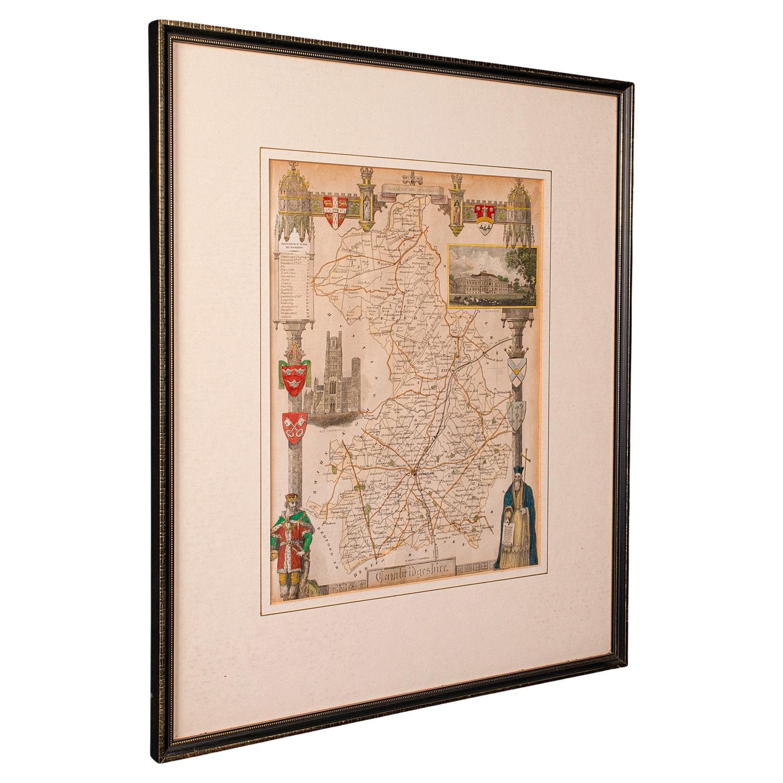
View AllAntique Lithography Map, Cambridgeshire, English, Framed Cartography, Victorian
Located in Hele, Devon, GB
This is an antique lithography map of Cambridgeshire. An English, framed atlas engraving of cartographic interest, dating to the mid 19th century and later.
Superb lithography of C...
Category
Antique Mid-19th Century British Victorian Maps
Materials
Glass, Wood, Paper
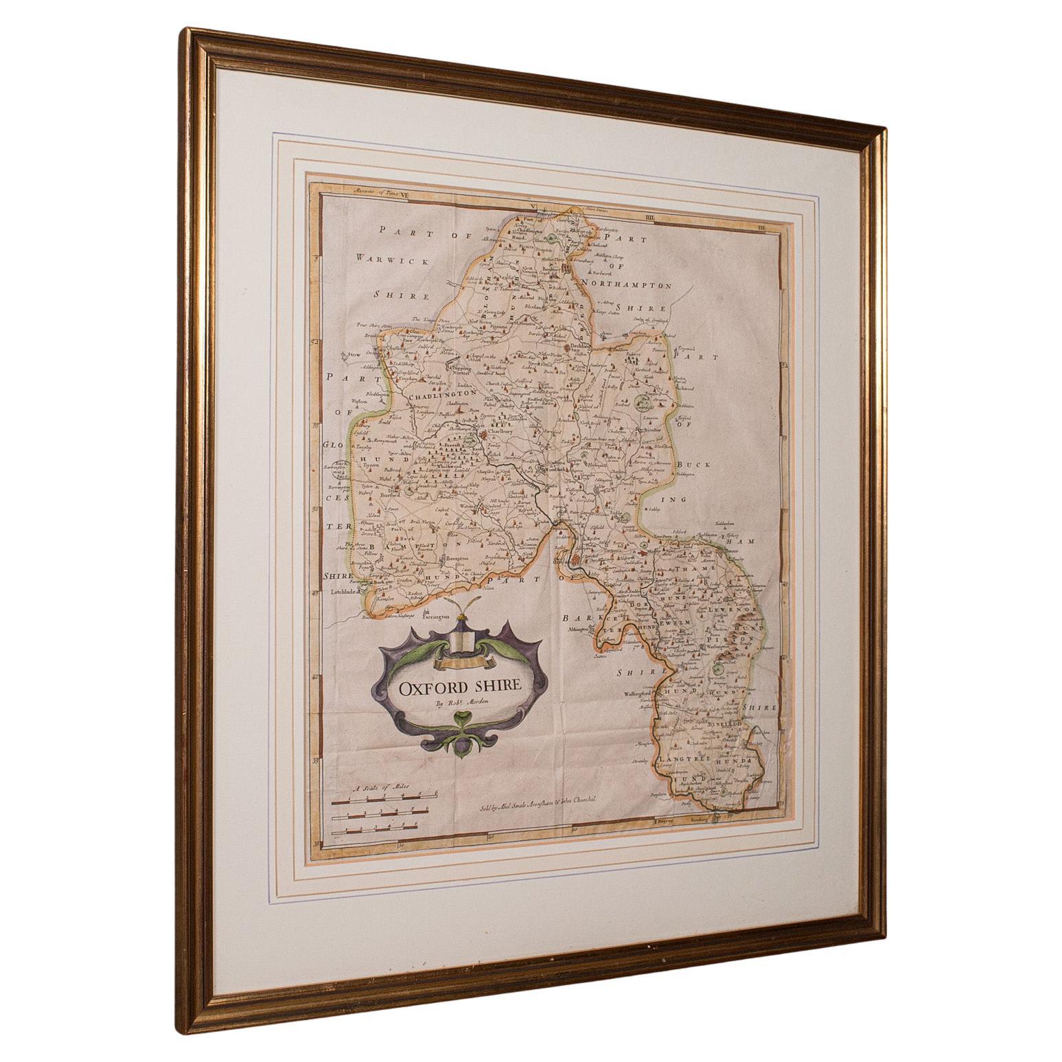
Antique Lithography Map, Oxfordshire, English, Framed Cartography, Robert Morden
Located in Hele, Devon, GB
This is an antique lithography map of Oxfordshire. An English, framed atlas engraving of cartographic interest by Robert Morden, dating to the late 17th century and later.
Superb l...
Category
Antique Late 17th Century British William and Mary Maps
Materials
Paper

Antique Lithography Map, Bedfordshire, English, Framed Engraving, Cartography
Located in Hele, Devon, GB
This is an antique lithography map of Bedfordshire. An English, framed atlas engraving of cartographic interest, dating to the mid 19th century and...
Category
Antique Mid-19th Century British Victorian Maps
Materials
Wood

Antique Lithography Map, Derbyshire, English, Framed Cartography, Victorian
Located in Hele, Devon, GB
This is an antique lithography map of Derbyshire. An English, framed atlas engraving of cartographic interest, dating to the mid 19th century and later.
Superb lithography of Derby...
Category
Antique Mid-19th Century British Victorian Maps
Materials
Glass, Wood, Paper

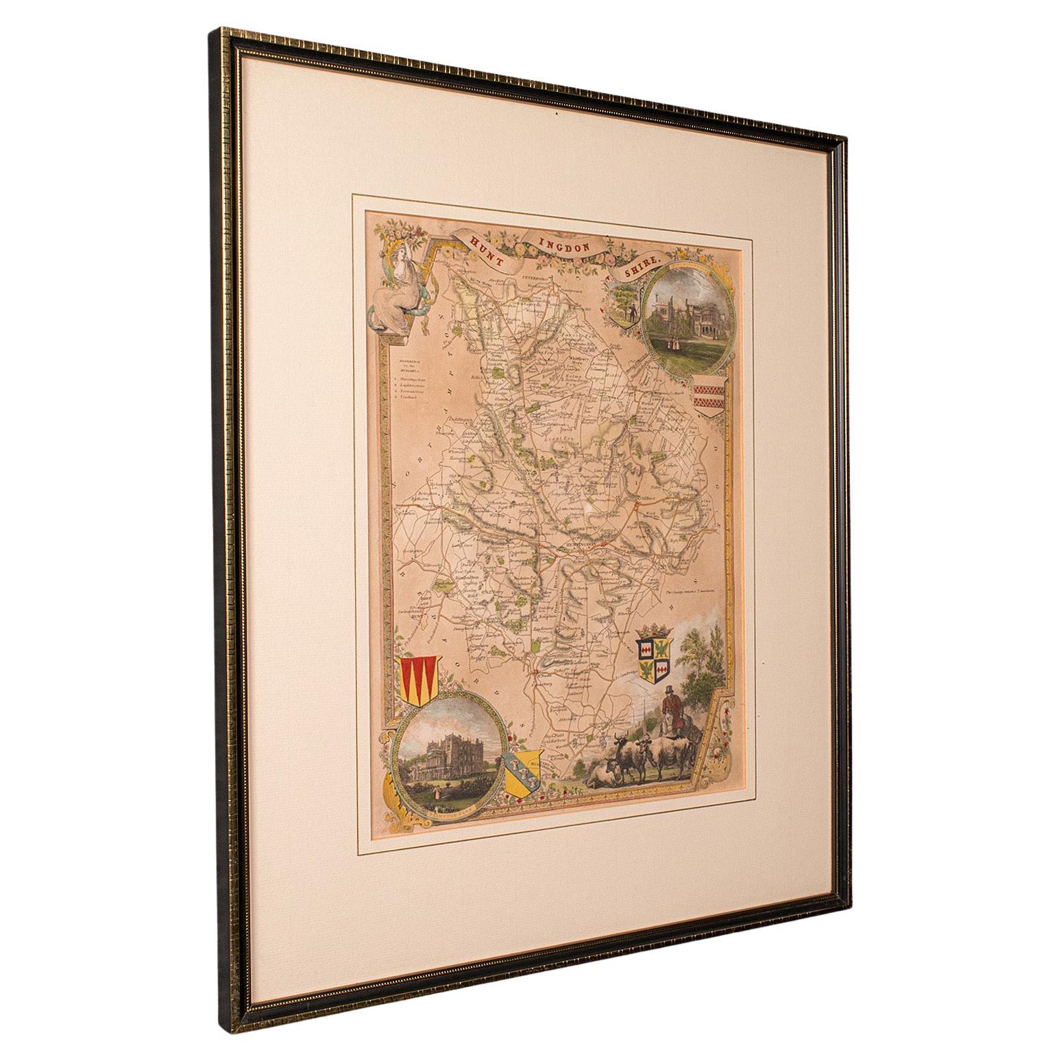
Antique Lithography Map, Huntingdonshire, English, Framed Cartography, Victorian
Located in Hele, Devon, GB
This is an antique lithography map of Huntingdonshire. An English, framed atlas engraving of cartographic interest, dating to the mid 19th century and later.
Superb lithography of ...
Category
Antique Mid-19th Century British Victorian Maps
Materials
Glass, Wood, Paper
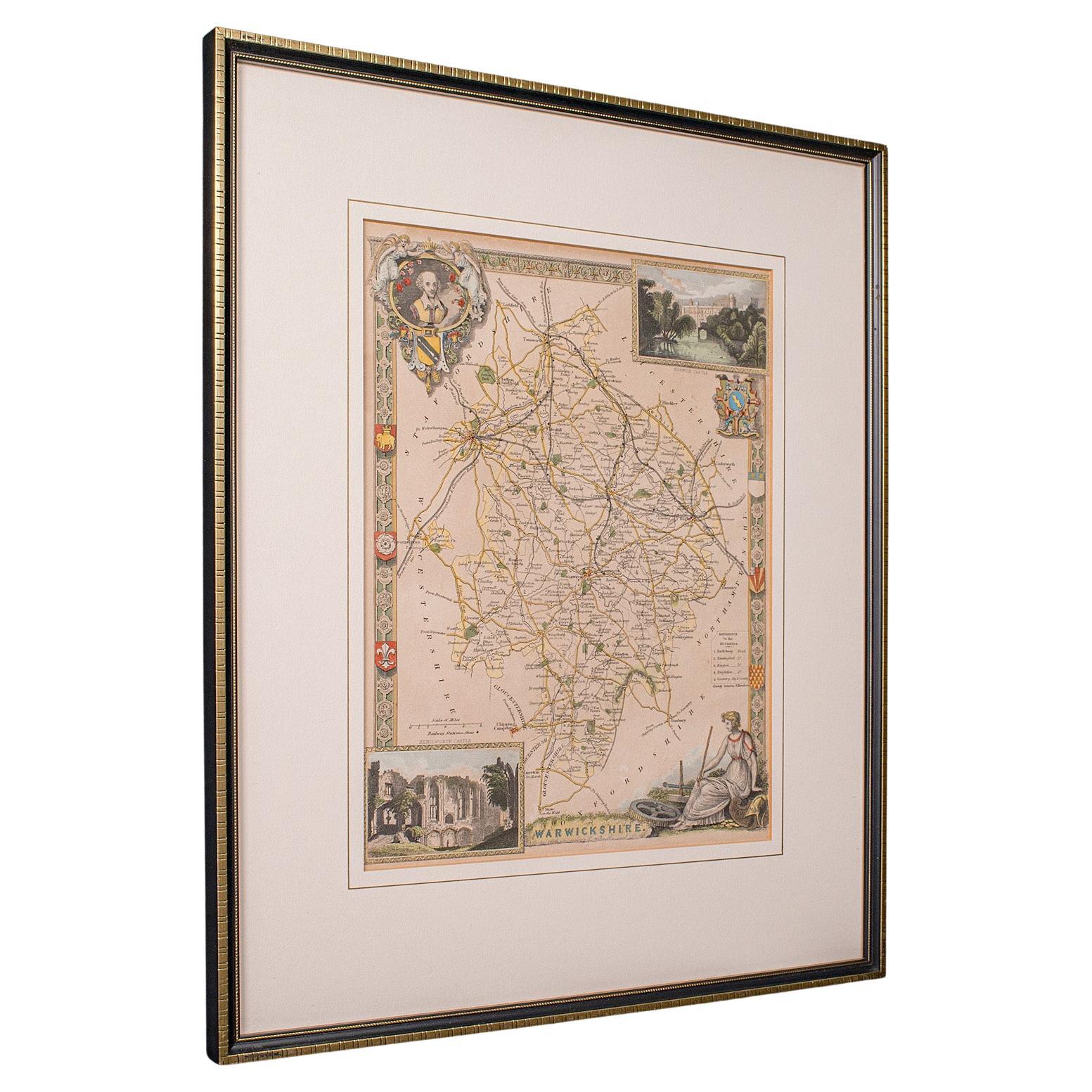
Antique Lithography Map, Warwickshire, English, Framed, Cartography, Victorian
Located in Hele, Devon, GB
This is an antique lithography map of Warwickshire. An English, framed atlas engraving of cartographic interest, dating to the mid 19th century and later.
Superb lithography of War...
Category
Antique Mid-19th Century British Victorian Maps
Materials
Glass, Wood, Paper
You May Also Like
Map Shropshire Joseph Ellis Robert Sayer Carington Bowles Framed
Located in BUNGAY, SUFFOLK
A modern map of Shropshire Drawn from the latest surveys corrected and improved by the best authorities.
Artist Joseph Ellis sculptor.
Joseph Ellis was an engraver and publisher from Clerkenwell in London and was apprenticed to Richard William Seale in 1749. He is best know to county map collectors for The New English Atlas published in 1765 which was later reissued as Ellis's English Atlas in 1766, 1768 1777, 1786, 1790 and 1796.
Maker carington bowles 1724 - 1793.
Carington Bowles worked in London as a publisher in partnership with his father John Bowles from about 1752 until 1763. Carington Bowles worked as a publisher in partnership with his father John Bowles from about 1752 until 1763 before taking over his uncle's business. His address was 69 St. Pauls Church Yard, London. He worked with a number of well known cartographers of the day including Emanuel Bowen, Thomas Kitchin, Robert Sayer...
Category
Antique 18th Century English Georgian Maps
Materials
Paper

Map Bedfordshire General Framed
Located in BUNGAY, SUFFOLK
A general map of Bedfordshire with its hundreds
A scale of 5 miles
in the original green mount and traditional black and gold frame. Measures: 36cm 14" high.
Category
Antique 18th Century English Georgian Maps
Materials
Paper

Antique Map of Essex by Overton, circa 1710
Located in Langweer, NL
Antique map titled 'Essex, devided into Hundreds, with the most antient and fayre Towne Colchester (..)'. Map of Essex, England. Includes an inset town pl...
Category
Antique Early 18th Century Maps
Materials
Paper

$910 Sale Price
20% Off
Framed 17th Century Map of Cumberland, England by John Speed, 1610
By John Speed
Located in Middleburg, VA
A fascinating and richly detailed antique map of Cumberland County in northwest England, drawn and published by the celebrated English cartographer John Spe...
Category
Antique Early 17th Century English British Colonial Maps
Materials
Copper, Gold Leaf

Map Bedfordshire No 3 General Framed
Located in BUNGAY, SUFFOLK
A general map of Bedfordshire with its hundreds. Measure: 37cm 14 1/2" high
A scale of 5 miles.
in the original green mount and traditional black and gold frame.
charming map with...
Category
Antique 18th Century English Georgian Maps
Materials
Paper

Antique Map of Leicester and Rutland by Tinney & Sayer, 'circa 1756'
Located in Langweer, NL
Antique map titled 'An Accurate Map of the Counties of Leicester and Rutland (..)'. Large map of Leicester and Rutland with dedications to the Most Noble John Duke of Rutland, and to...
Category
Antique Mid-18th Century Maps
Materials
Paper

$766 Sale Price
20% Off
More Ways To Browse
Framed Coat Of Arms
Coat Of Arms Panel
17th Century Jacobean
17th Jacobean
Used Furniture Northampton
Grant Speed
Silver Over Copper
Vintage Barware Glasses
Coffee Table Black Italian Modern
Christofle America
Iranian Silk Rug Carpet
Poul Moller
Tables With Inlaid Wood
World War Table
Antonio Jacobsen
Ariston Chairs
Coffee Tables Europe
Marble Top Dining Tables