Items Similar to Large Map of Castile's Southern Realms - Granada, Andalusia, and Murcia, 1652

Want more images or videos?
Request additional images or videos from the seller
1 of 7
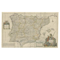
Large Map of Castile's Southern Realms - Granada, Andalusia, and Murcia, 1652
$459.93
$574.9220% Off
£340.83
£426.0420% Off
€384
€48020% Off
CA$627.89
CA$784.8720% Off
A$698.51
A$873.1320% Off
CHF 366.17
CHF 457.7120% Off
MX$8,535.59
MX$10,669.4820% Off
NOK 4,662.67
NOK 5,828.3420% Off
SEK 4,389.26
SEK 5,486.5720% Off
DKK 2,923.74
DKK 3,654.6820% Off
Shipping
Retrieving quote...The 1stDibs Promise:
Authenticity Guarantee,
Money-Back Guarantee,
24-Hour Cancellation
About the Item
This antique map, titled 'Les Etats de la Couronne de Castille', represents the southern regions of the Crown of Castile, specifically the territories of Andalusia, Granada, and Murcia. Created by the renowned French cartographer Nicolas Sanson and published by Pierre Mariette, it is a piece dating back to around 1652.
The map is intricately detailed, featuring the names of many towns and geographical features in a dense, script-like font. The boundaries of each region are outlined in colored lines, with Andalusia, Granada, and Murcia distinctly marked. Major rivers and mountain ranges are illustrated, providing a sense of the varied topography of the region.
The cartouche in the upper left corner is an elegant design, typical of the period's style, with the title of the map inscribed within. The map includes a scale bar (‘Echelle’) in the upper right corner, which would allow the viewer to understand distances on the map.
While the map itself is designed for practical use, it also serves as a historical document, showing the division of territories and the extent of the Spanish empire's reach in the mid-17th century. It's a fine example of cartographic artistry from the time, combining functionality with aesthetic detail.
When people search for antique maps or historical information about the area covered in the map, which represents the southern parts of the Crown of Castile during the mid-17th century, they often look for famous cities and landmarks that are still relevant and popular today. From the current sources, several key locations stand out as statistically significant:
1. **Granada**: Known for the Alhambra fortress complex, the old town Albaicin neighborhood, and its cathedral, Granada is a city rich in history and culture. Its Moorish influence and beautiful landscapes make it a frequent search subject for those interested in Andalusian heritage
2. **Cádiz**: As one of the oldest cities in Western Europe, founded by the Phoenicians around 1100 BC, Cádiz is renowned for its beaches like La Caleta, historic quarter, and ancient buildings such as the Santa Catalina Fortress. The intricate network of narrow streets and landmarks like the church of Santa Cruz and the Roman theater make it a city of interest
3. **Jerez de la Frontera**: Known as the birthplace of sherry, this city is celebrated for its sherry bodegas, the Alcázar, and its cathedral. It's also considered the cradle of flamenco dance, adding to its cultural allure
4. **Marbella**: Famous for its Old Town and beaches, Marbella strikes a balance between modern luxury and traditional Andalusian charm, featuring whitewashed buildings and flower-laden streets
5. **Malaga**: As the birthplace of Picasso, Malaga is a culturally dynamic city with historic sites such as the Alcazaba fortress and the old Roman Amphitheater. It's also a hub for galleries, restaurants, and nightlife
6. **Ronda**: This town is known for its dramatic location on the El Tajo Gorge and its historical association with bandoleros (bandits). It's famous for its Puente Nuevo bridge and its place in the tradition of bullfighting
These cities, among others like Seville and Cordoba, are not only key historical locations but also remain vibrant and sought-after travel destinations today.
- Dimensions:Height: 17.64 in (44.8 cm)Width: 23.75 in (60.3 cm)Depth: 0.02 in (0.5 mm)
- Materials and Techniques:
- Period:Mid-17th Century
- Date of Manufacture:c.1652
- Condition:General age-related toning. Original folding line. Two small defects in right margin. Minor wear, blank verso. Please study image carefully.
- Seller Location:Langweer, NL
- Reference Number:Seller: BG-13431-11stDibs: LU3054338206572
About the Seller
5.0
Recognized Seller
These prestigious sellers are industry leaders and represent the highest echelon for item quality and design.
Platinum Seller
Premium sellers with a 4.7+ rating and 24-hour response times
Established in 2009
1stDibs seller since 2017
2,502 sales on 1stDibs
Typical response time: <1 hour
- ShippingRetrieving quote...Shipping from: Langweer, Netherlands
- Return Policy
Authenticity Guarantee
In the unlikely event there’s an issue with an item’s authenticity, contact us within 1 year for a full refund. DetailsMoney-Back Guarantee
If your item is not as described, is damaged in transit, or does not arrive, contact us within 7 days for a full refund. Details24-Hour Cancellation
You have a 24-hour grace period in which to reconsider your purchase, with no questions asked.Vetted Professional Sellers
Our world-class sellers must adhere to strict standards for service and quality, maintaining the integrity of our listings.Price-Match Guarantee
If you find that a seller listed the same item for a lower price elsewhere, we’ll match it.Trusted Global Delivery
Our best-in-class carrier network provides specialized shipping options worldwide, including custom delivery.More From This Seller
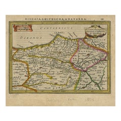
View AllAntique Map of Northeastern Spain by Mercator, 1634
Located in Langweer, NL
Antique map titled 'Biscaia, Guipiscoa, Navarra et Asturias de Santillana'. Charming map of Northeastern Spain with the areas of Pamplona and Valladolid. This map originates from 'At...
Category
Antique 17th Century Maps
Materials
Paper
$133 Sale Price
20% Off
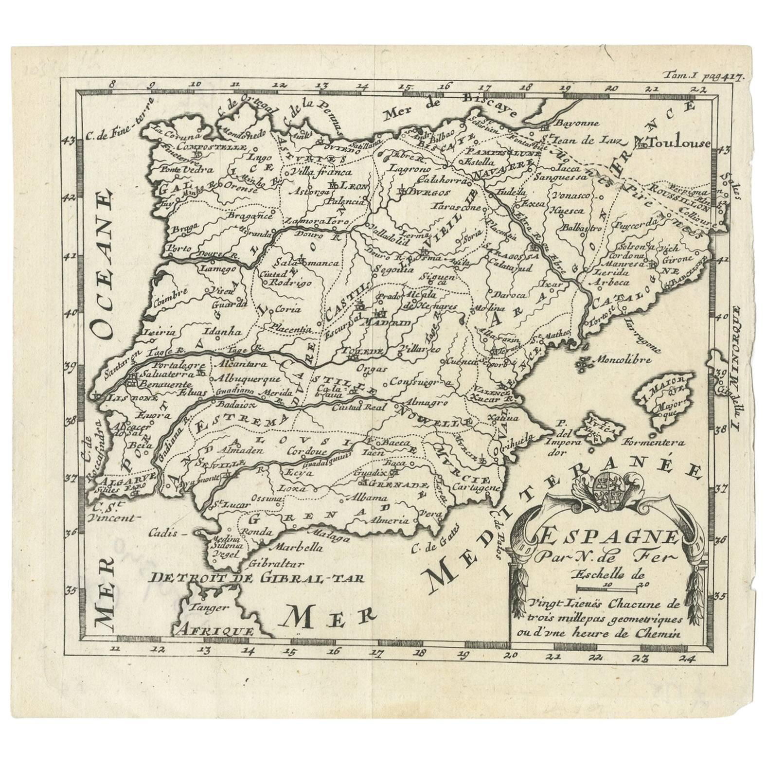
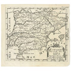
Antique Map of Spain by N. de Fer, circa 1700
Located in Langweer, NL
Antique map of Spain and Portugal with a title cartouche. Nicolas de Fer was the youngest son of the Paris printer and publisher Antoine de Fer. At the ...
Category
Antique Early 18th Century Maps
Materials
Paper
$153 Sale Price
20% Off
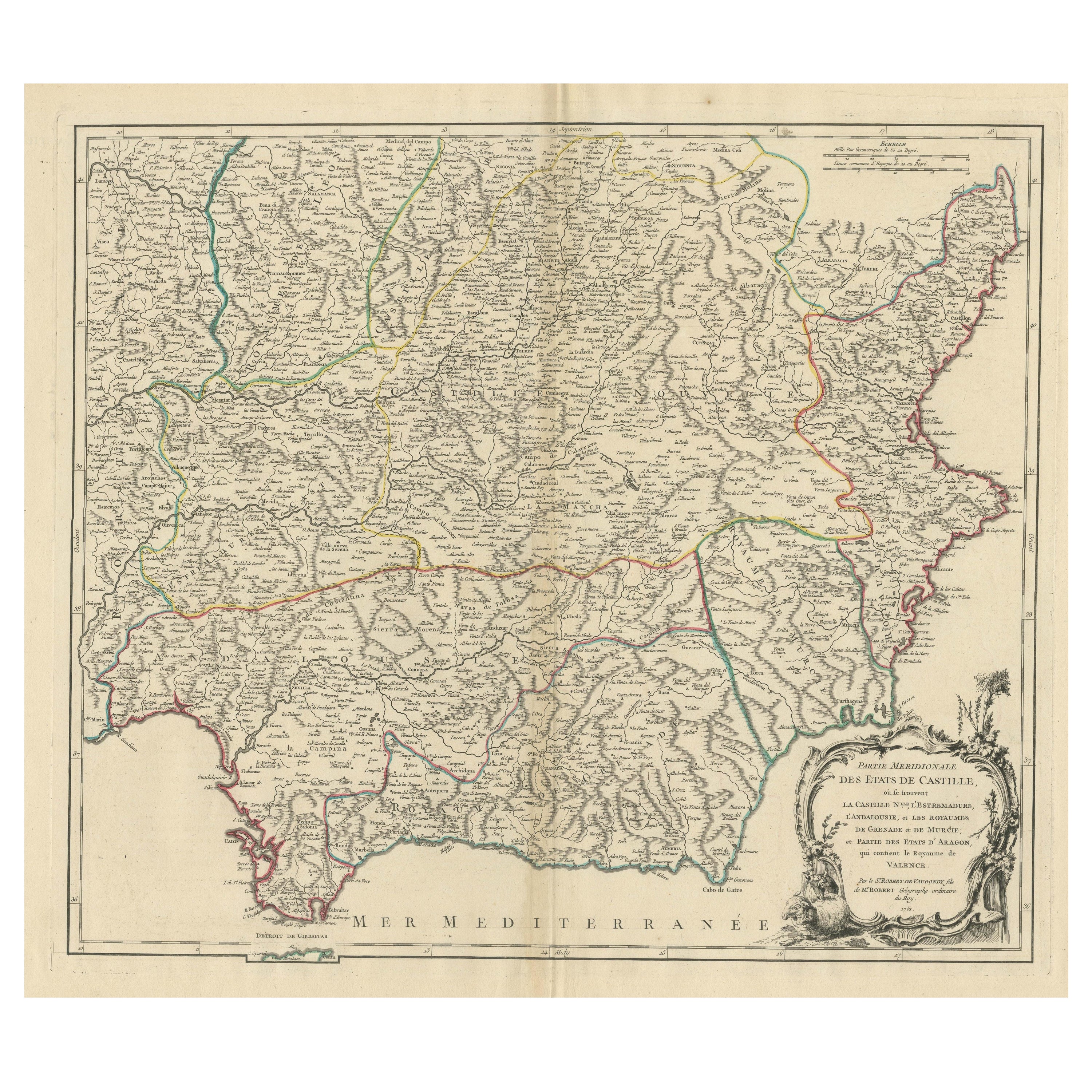
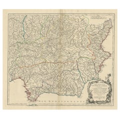
Map of Southern Spain Depicting Castile, Andalusia, Granada, Murcia and Valencia
Located in Langweer, NL
Antique map titled 'Partie Meridionale Des Etats de Castille (..)'. Decorative and highly detailed map of the southern part of Castile, Spain, including a decorative cartouche. Publi...
Category
Antique Mid-18th Century Maps
Materials
Paper
$632 Sale Price
20% Off
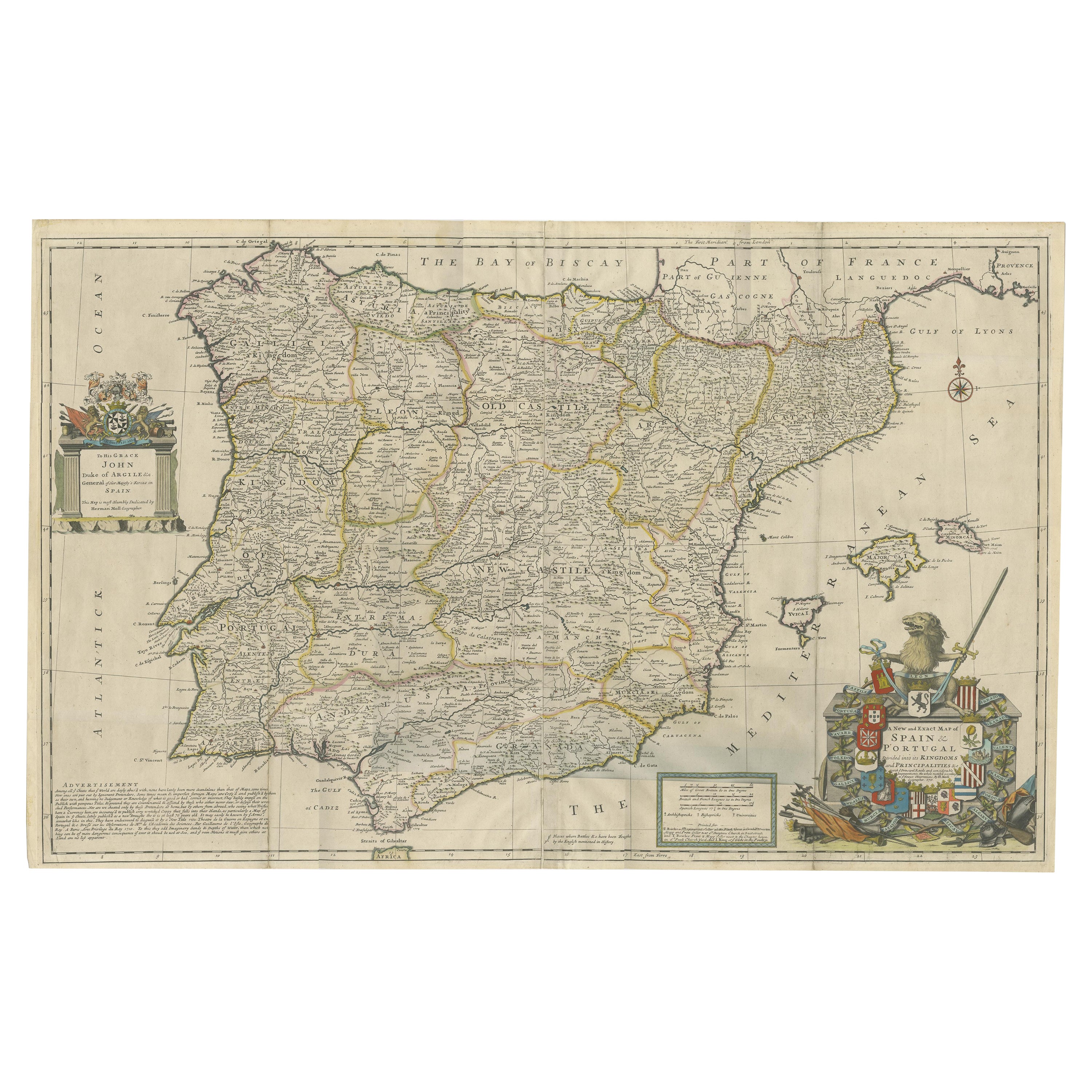
Beautiful Large Scale Map of Spain and Portugal Published by Herman Moll in 1711
Located in Langweer, NL
Title: A New and Exact Map of Spain & Portugal
Author: Herman Moll
Date: 1711
Medium: Hand-colored copperplate engraving
Herman Moll (c. 1654-1732) was one of the most important London mapmakers in the first half of the eighteenth century. Moll was probably born in Bremen, Germany, around 1654. He moved to London to escape the Scanian Wars. His earliest work was as an engraver for Moses Pitt on the production of the English Atlas, a failed work which landed Pitt in debtor's prison. Moll also engraved for Sir Jonas Moore, Grenville Collins, John Adair, and the Seller & Price firm. He published his first original maps in the early 1680s and had set up his own shop by the 1690s.
Moll's work quickly helped him become a member of a group which congregated at Jonathan's Coffee House at Number 20 Exchange Alley, Cornhill, where speculators met to trade stock. Moll's circle included the scientist Robert Hooke...
Category
Antique 1710s Maps
Materials
Paper
$2,395 Sale Price
20% Off
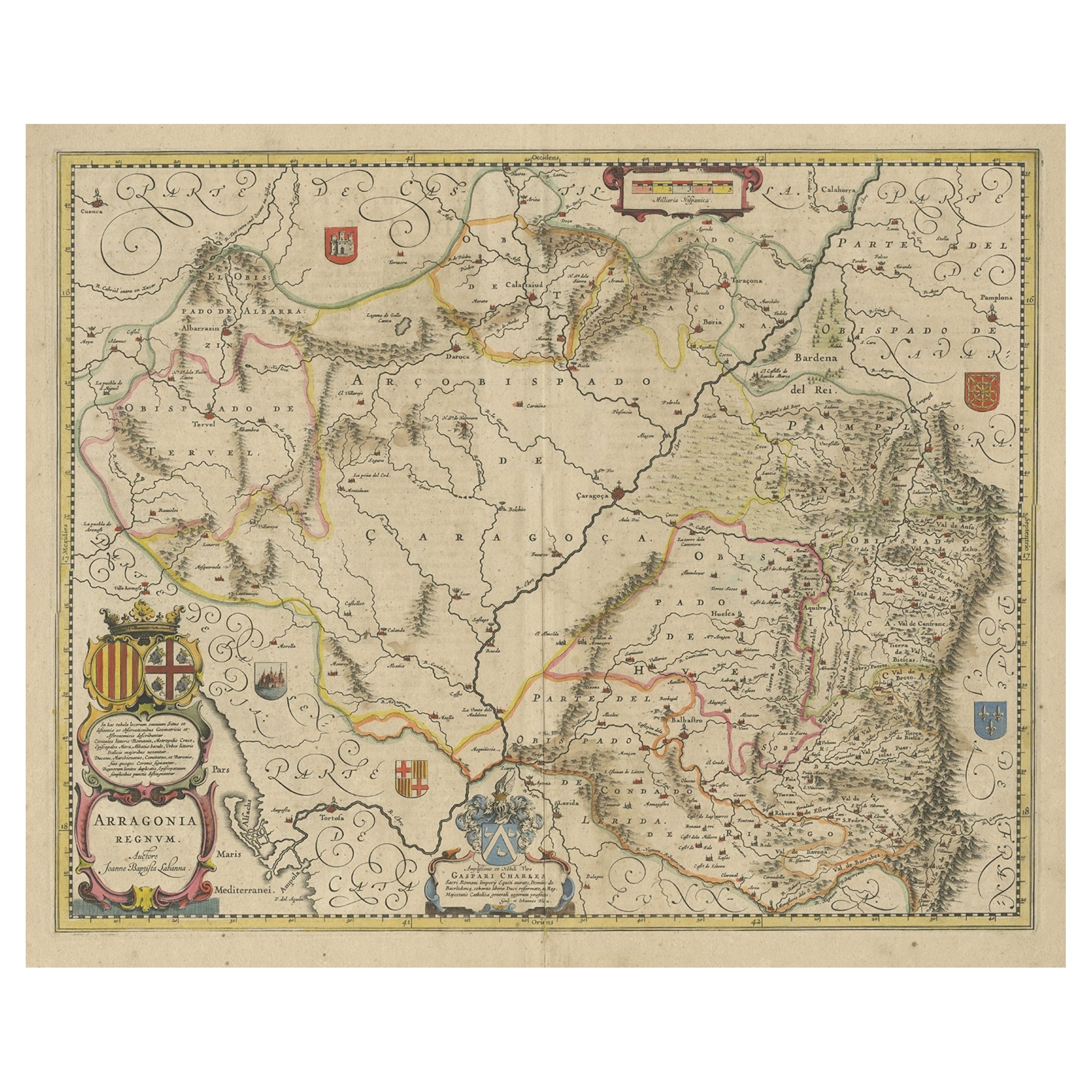
Detailed Antique Map of Northern Spanish Region of Aragon, c.1650
Located in Langweer, NL
Antique map titled 'Arragonia Regnum'.
Detailed map of northern Spanish region of Aragon. The map is centered on the city of Zaragoza, aka, Saragossa. Shows towns, rivers, castle...
Category
Antique 1650s Maps
Materials
Paper
$1,101 Sale Price
20% Off
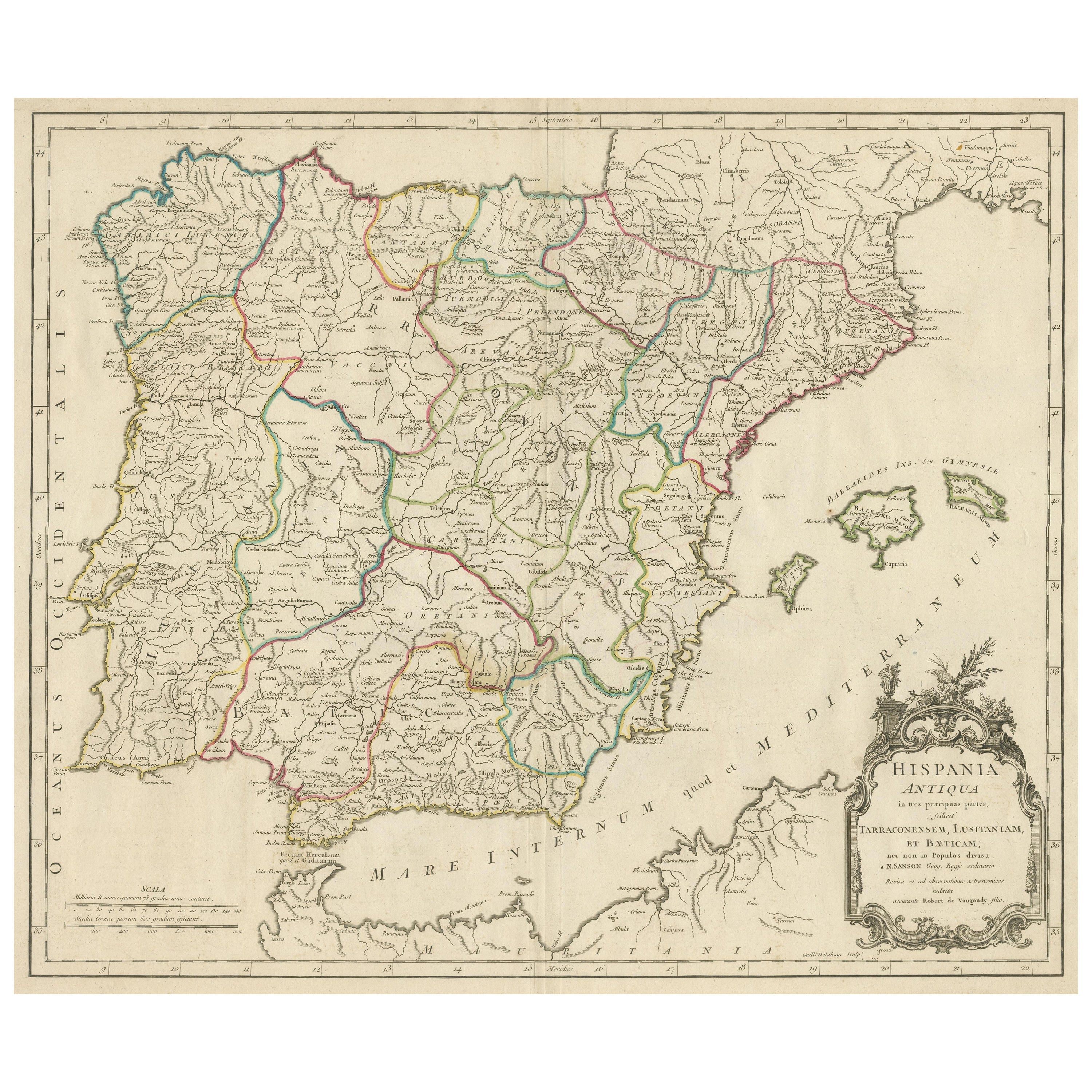
Large Antique Map of Ancient Spain and Portugal, Published in circa 1760
Located in Langweer, NL
Antique map titled 'Hispania Antiqua (..)'. Map of ancient Spain and Portugal. Engraved by G. Delahaye. Published circa 1760, by or after Sanson & Vaugondy.
Category
Antique Mid-18th Century Maps
Materials
Paper
$421 Sale Price
20% Off
You May Also Like
Original Antique Map of Spain and Portugal, circa 1790
Located in St Annes, Lancashire
Super map of Spain and Portugal
Copper plate engraving by A. Bell
Published, circa 1790.
Unframed.
Category
Antique 1790s English Other Maps
Materials
Paper

18th Century Hand Colored Map of Spain and Portugal by Visscher
By Nicolaes Visscher II
Located in Alamo, CA
This is an early 18th century map of Spain and Portugal, with attractive original hand-coloring, entitled "Hispaniae et Portugalliae Regna per Nicolaum Visscher cum Privilegio Ordinu...
Category
Antique Early 18th Century Dutch Maps
Materials
Paper

1751 Map of Spain Castilla Robert De Vaugondy 1st Edition, Ric.a001
Located in Norton, MA
Large Spain Castilla Robert De Vaugondy
1751 1st Edition
-Colored- Ric.a001
Coming from a family of cartographers, a descendant of the famous Nicolas Sanson and ordinary geographer of the king, Gilles Robert de Vaugondy makes himself known by his maps of the French provinces.
He published an Essay on the History of Geography (1755) from which he excluded the physical geography "too systematic". After a Small Atlas (1748), he draws a universal Atlas (1758), a portable Atlas (1762).
His Atlas of the revolutions of the globe remains unpublished. His warnings and prefaces, his book reviews reveal a Cartesian mind and solid knowledge.
Very early, he associates with his works his son Didier who publishes, since 1742, the methodical tables of Nicolas Sanson, two Globes, one terrestrial, the other celestial (1752).
He is credited with a map of Poland...
Category
Antique 18th Century Unknown Maps
Materials
Paper

Portugal: A Large 17th Century Hand-colored Map by Sanson and Jaillot
By Nicolas Sanson
Located in Alamo, CA
This large hand-colored map entitled "Le Royaume de Portugal et des Algarves Divisee en see Archeveches, Eveches et Territoires Par le Sr Sanson" was originally created by Nicholas S...
Category
Antique 1690s French Maps
Materials
Paper

17th Century Lithograph Framed Map of Spain
Located in Atlanta, GA
In giltwood frame, dated 1652.
Category
Antique 18th Century and Earlier Spanish Baroque Prints
Materials
Ink, Paper

Portugal: A Large 17th Century Hand-colored Map by Sanson and Jaillot
By Nicholas Sanson d'Abbeville
Located in Alamo, CA
This large hand-colored map entitled "Le Royaume de Portugal et des Algarves Divisee en see Archeveches, Eveches et Territoires Par le Sr Sanson" was originally created by Nicholas S...
Category
1690s Landscape Prints
Materials
Engraving

More Ways To Browse
Antique Scales And Balances
Alhambra Furniture
Empire Strikes Back
French Antique Font
Antique Sherry
Cathedral Crown
Spanish Andalusia
Santa Cruz Used Furniture
Church Font
Antique Furniture Santa Cruz
Roman Antique Font
Early American Chairs
Hans Muller
Vintage Wood Table With Glass Top
19th Century Square Table
Antonio Bonet
Galle Chairs
Large Chinese Rug