Items Similar to Beautiful Large Scale Map of Spain and Portugal Published by Herman Moll in 1711


Want more images or videos?
Request additional images or videos from the seller
1 of 5
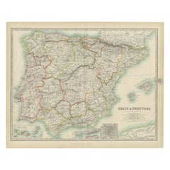
Beautiful Large Scale Map of Spain and Portugal Published by Herman Moll in 1711
About the Item
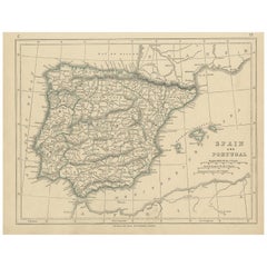
Title: A New and Exact Map of Spain & Portugal
Author: Herman Moll
Date: 1711
Medium: ?Hand-colored copperplate engraving
Condition: Very good - light age toning, light wear and discoloration along issued quatrefolds, surface dirt, minor creasing throughout,. Large engraved map on two conjoined sheets, contemporary outline colouring with some later enhancement inches.
Herman Moll (c. 1654-1732) was one of the most important London mapmakers in the first half of the eighteenth century. Moll was probably born in Bremen, Germany, around 1654. He moved to London to escape the Scanian Wars. His earliest work was as an engraver for Moses Pitt on the production of the English Atlas, a failed work which landed Pitt in debtor's prison. Moll also engraved for Sir Jonas Moore, Grenville Collins, John Adair, and the Seller & Price firm. He published his first original maps in the early 1680s and had set up his own shop by the 1690s.
Moll's work quickly helped him become a member of a group which congregated at Jonathan's Coffee House at Number 20 Exchange Alley, Cornhill, where speculators met to trade stock. Moll's circle included the scientist Robert Hooke, the archaeologist William Stuckley, the authors Jonathan Swift and Daniel Defoe, and the intellectually-gifted pirates William Dampier, Woodes Rogers and William Hacke. From these contacts, Moll gained a great deal of privileged information that was included in his maps.
Over the course of his career, he published dozens of geographies, atlases, and histories, not to mention numerous sheet maps. His most famous works are Atlas Geographus, a monthly magazine that ran from 1708 to 1717, and The World Described (1715-54). He also frequently made maps for books, including those of Dampier’s publications and Swift’s Gulliver’s Travels. Moll died in 1732. It is likely that his plates passed to another contemporary, Thomas Bowles, after this death.
- Dimensions:Height: 24.81 in (63 cm)Width: 39.38 in (100 cm)Depth: 0.02 in (0.5 mm)
- Materials and Techniques:
- Period:1710-1719
- Date of Manufacture:1711
- Condition:
- Seller Location:Langweer, NL
- Reference Number:
About the Seller
5.0
Platinum Seller
These expertly vetted sellers are 1stDibs' most experienced sellers and are rated highest by our customers.
Established in 2009
1stDibs seller since 2017
1,922 sales on 1stDibs
Typical response time: <1 hour
- ShippingRetrieving quote...Ships From: Langweer, Netherlands
- Return PolicyA return for this item may be initiated within 14 days of delivery.
More From This SellerView All
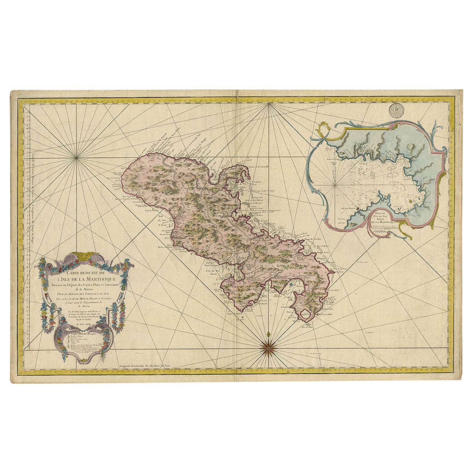
- Stunning Large Scale Antique Map of Martinique, Rare, Published 1758Located in Langweer, NLAntique map titled 'Carte Reduite de l'Isle de la Martinique Dressee au Depost des Cartes Plans et Journaux de la Marine.' Superb, large scale chart of ...Category
Antique 18th Century Maps
MaterialsPaper
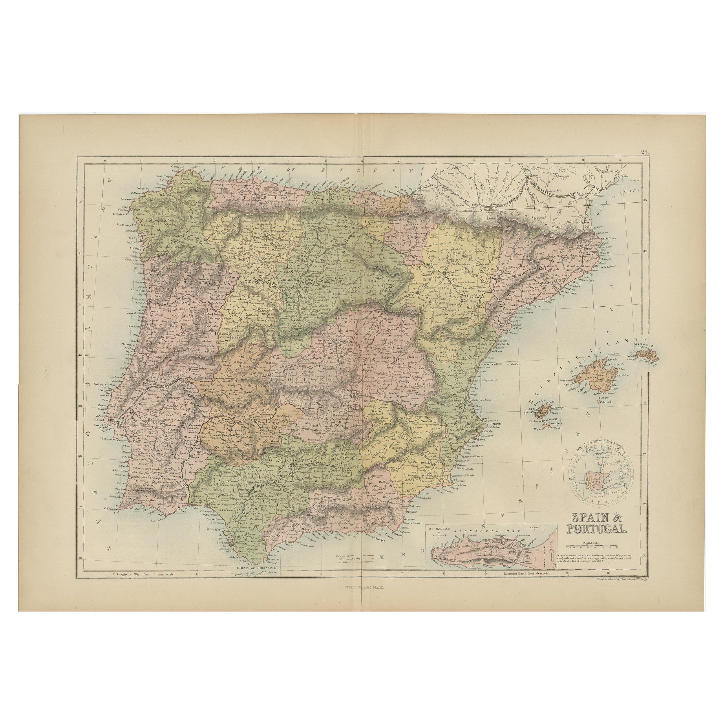
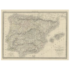
- Antique Map of Spain and Portugal by A & C. Black, 1870Located in Langweer, NLAntique map titled 'Spain and Portugal'. Original antique map of General map of Spain and Portugal with inset map of Gibraltar. This map originates from ‘Black's General Atlas of The...Category
Antique Late 19th Century Maps
MaterialsPaper
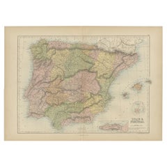
- Antique Map of Spain and Portugal by Lowry, '1852'Located in Langweer, NLAntique map titled 'Spain and Portugal'. Original map of Spain and Portugal. This map originates from 'Lowry's Table Atlas constructed and engraved ...Category
Antique Mid-19th Century Maps
MaterialsPaper
- Antique Map of Spain and Portugal by Levasseur, '1875'Located in Langweer, NLAntique map titled 'Carte générale de l'Espagne et du Portugal (..)'. Large map of Spain and Portugal. This map originates from 'Atlas de Géographie Moder...Category
Antique Late 19th Century Maps
MaterialsPaper
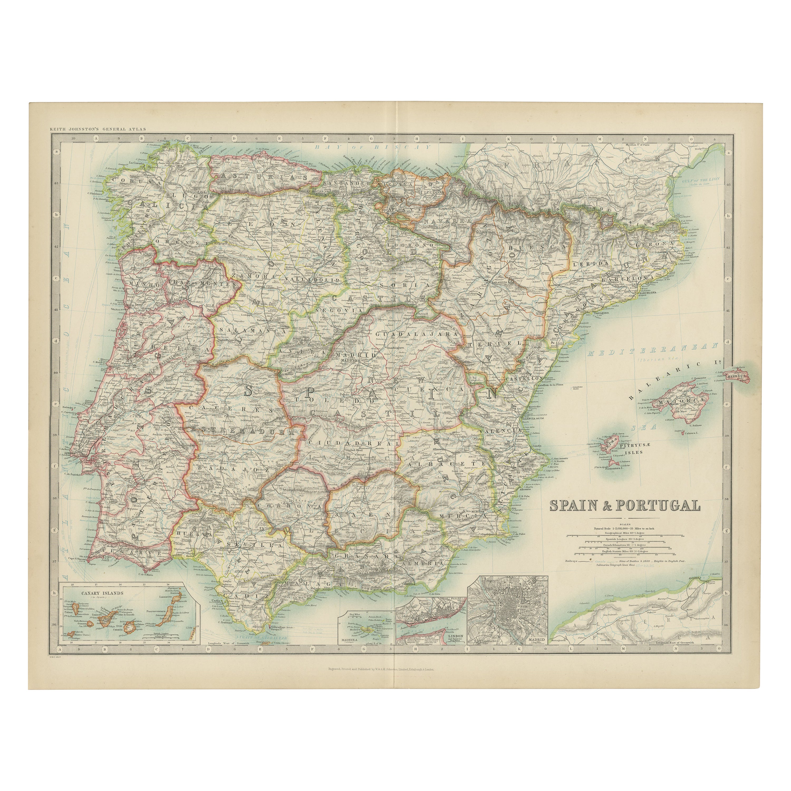
- Antique Map of Spain and Portugal by Johnston, '1909'Located in Langweer, NLAntique map titled 'Spain and Portugal'. Original antique map of Spain and Portugal. With inset maps of the Canary Islands, Madeira, Lisbon and Ma...Category
Early 20th Century Maps
MaterialsPaper
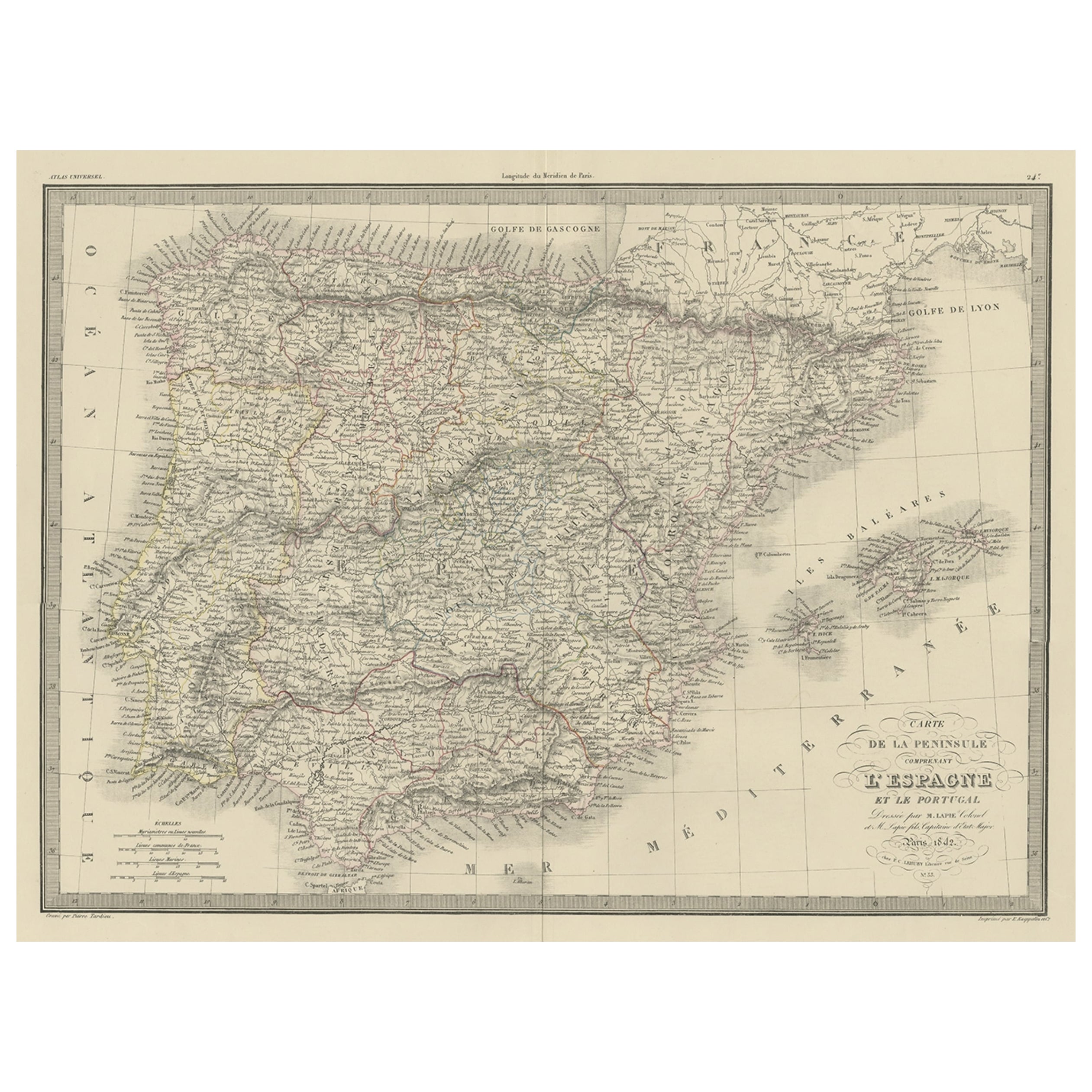
- Antique Decorative Map of Portugal and Spain, 1842Located in Langweer, NLAntique map titled 'Carte de la Peninsule comprenant l'Espagne et le Portugal'. Map of Spain and Portugal. This map originates from 'Atlas universel de géographie ancienne et mod...Category
Antique 1840s Maps
MaterialsPaper

You May Also Like
- Original Antique Map of Spain and Portugal, circa 1790Located in St Annes, LancashireSuper map of Spain and Portugal Copper plate engraving by A. Bell Published, circa 1790. Unframed.Category
Antique 1790s English Other Maps
MaterialsPaper
- Original Antique Map of Spain and Portugal by Thomas Clerk, 1817Located in St Annes, LancashireGreat map of Spain and Portugal Copper-plate engraving Drawn and engraved by Thomas Clerk, Edinburgh. Published by Mackenzie And Dent, 1817 Unframed.Category
Antique 1810s English Maps
MaterialsPaper
- Original Antique Map of Spain and Portugal, Engraved By Barlow, 1806Located in St Annes, LancashireGreat map of Spain And Portugal Copper-plate engraving by Barlow Published by Brightly & Kinnersly, Bungay, Suffolk. 1806 Unframed.Category
Antique Early 1800s English Maps
MaterialsPaper
- 18th Century Hand Colored Map of Spain and Portugal by VisscherBy Nicolaes Visscher IILocated in Alamo, CAThis is an early 18th century map of Spain and Portugal, with attractive original hand-coloring, entitled "Hispaniae et Portugalliae Regna per Nicolaum Visscher cum Privilegio Ordinu...Category
Antique Early 18th Century Dutch Maps
MaterialsPaper
- Portugal: A Large 17th Century Hand-colored Map by Sanson and JaillotBy Nicolas SansonLocated in Alamo, CAThis large hand-colored map entitled "Le Royaume de Portugal et des Algarves Divisee en see Archeveches, Eveches et Territoires Par le Sr Sanson" was originally created by Nicholas S...Category
Antique 1690s French Maps
MaterialsPaper
- 17th Century Hand-Colored Map of Valencia and Murcia, Spain by Mercator/HondiusBy Gerard MercatorLocated in Alamo, CAA 17th century hand-colored map entitled "Regni Valentiae Typus, Valentia and Murcia" by Gerard Mercator and Joducus Hondius, published in Amsterdam in 1635 in 'Cosmographicall Descr...Category
Antique Mid-17th Century Dutch Maps
MaterialsPaper


Recently Viewed
View AllMore Ways To Browse
Antique Wood Scale
Antique English Scales
Antique Scales Collectables
Antique Scales Collectibles
Antique Scales Collectable Scales
Spanish Shops
Antique Shop Collectables
Antique And Collectible Shop
Trading Scales
Antique Scale Plate
Spanish Plate Large
Large Map Of The World
Scale Map
Antique Coffee Collectibles
Map Spain
Maps Spain
Map Of Spain
Large Maps On Paper